Link:
http://www.wunderground.com/blog/JeffMa ... amp=200809Serious flooding in Puerto Rico from 93L
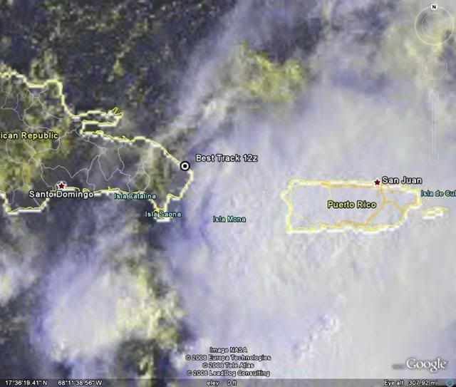
Tropical disturbance 93L continues to dump torrential rains of up to four inches per hour on Puerto Rico. Storm total rainfall amounts have exceeded 20 to 30 inches in parts of southeast Puerto Rico where rivers are up to 14 feet above flood stage. Flash floods and mudslides have been reported across the east, southeast, and southeastern interior Puerto Rico. An additional 10-20 inches of rain is expected over western and southwestern Puerto Rico today, due to the very slow motion of 93L. The rains from 93L are the most that have fallen on the island since Hurricane Georges ten years ago (see below).
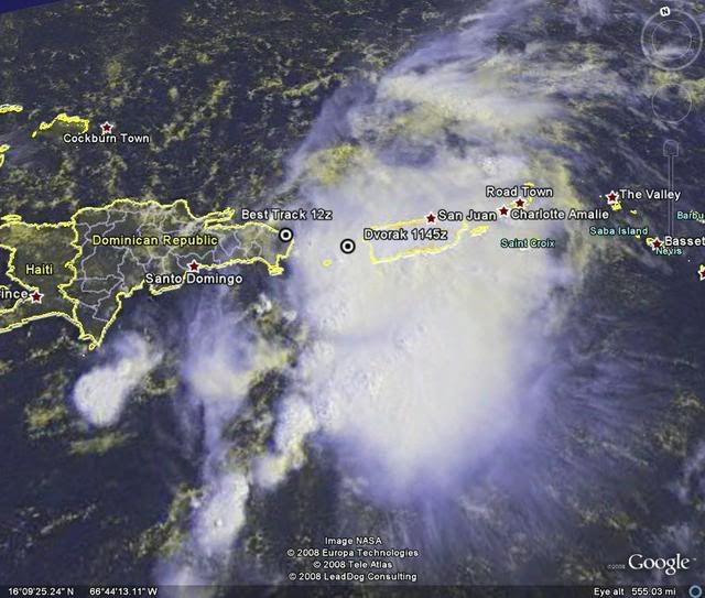
Infrared satellite loops show that heavy thunderstorm activity remains intense, and upper-level outflow is now established on the north and east sides of 93L. Puerto Rico radar was down this morning, but Dominican Republic radar shows evidence of spiral bands beginning to form around the center, which appears to have pushed over the eastern tip of the Dominican Republic, near Punta Cana. Winds have now shifted to westerly there, and this morning's QuikSCAT pass showed a large area of westerly winds to the south of Hispaniola, so 93L may have developed enough of a surface circulation to be classified as a tropical depression today. Wind shear is moderate, about 10-20 knots.
Expect heavy rains of up to 10-20 inches to affect Puerto Rico and the eastern Dominican Republic today through Tuesday from this slow moving storm. Heavy rains will also spread over eastern portions of the Dominican Republic Monday, potentially causing life-threatening flash floods and mudslides in mountainous regions. Since most of 93L's heavy thunderstorm activity is on its east side, it currently appears that Haiti and the Bahamas will escape dangerous heavy rains from this storm.
The intensity forecast
Wind shear is forecast to remain 10-20 knots over the next five days, and most of the reliable forecast models predict that 93L will develop into a tropical storm by Tuesday. The GFDL and HWRF models predict 93L will strengthen into a Category 1 or 2 hurricane by Thursday. However, there will be high wind shear very close to 93L for the next five days, and the storm may struggle at times with this high shear. Water temperatures are a warm 29°C and ocean heat content will be moderate over the next five days. The NHC is giving 93L a high (>50% chance) of developing into a tropical depression by Wednesday. A Hurricane Hunter aircraft will investigate 93L Monday afternoon.
The track forecast
The models agree on a slow west-northwesterly motion for 93L today, and passage over the mountainous terrain of Hispaniola may significantly disrupt the storm. By Tuesday, 93L is expected to turn north-northwest and head towards North Carolina. A major complicating factor in the long-range track forecast is the expected development of an extratropical storm off the coast of South Carolina. This low could bring hostile wind shear over 93L, weakening it, and potentially converting it into a subtropical storm. The two storms may rotate cyclonically around a common center (the Fujiwhara effect), sending the extratropical low west-southwestward into the Southeast U.S., and 93L northwestwards towards North Carolina. This is the solution of the 06Z (2 am EDT) GFDL and HWRF model runs, which both take 93L into New Jersey on Friday night as a borderline tropical storm/Category 1 hurricane. The NOGAPS and UKMET models predict that 93L will absorb the energy that would have gone into creating the extratropical low. This might convert 93L into a hybrid subtropical storm that would affect the coast of North and South Carolina late this week with sustained winds in the 50-60 mph range. I don't have a good feel for what will happen in this complicated situation, but it currently appears that coastal North Carolina may get tropical storm force winds from the extratropical storm beginning as early as Wednesday night. Residents along the entire U.S. East Coast from Georgia to Maine should anticipate the possibility of a strong tropical tropical storm affecting them late this week.