ATL: Tropical Storm Kyle : Discussion

Moderator: S2k Moderators

Message
Author
User avatar
Lowpressure
S2K Supporter
S2K Supporter
Posts: 2032
Age: 58
Joined: Sun Sep 14, 2003 9:17 am
Location: Charlotte, North Carolina

Re: ATL INVEST 93L: Discussion

#461 Postby Lowpressure » Mon Sep 22, 2008 7:04 am

cycloneye wrote:A more closer view.

Image

That is a good looking "cluster of thunderstorms" One would think a LLC almost has to form today under that canopy, with lessening shear.
0 likes   

User avatar
HURAKAN
Professional-Met
Professional-Met
Posts: 46086
Age: 38
Joined: Thu May 20, 2004 4:34 pm
Location: Key West, FL
Contact:

Re: ATL INVEST 93L: Discussion

#462 Postby HURAKAN » Mon Sep 22, 2008 7:26 am

Image
0 likes   

User avatar
HURAKAN
Professional-Met
Professional-Met
Posts: 46086
Age: 38
Joined: Thu May 20, 2004 4:34 pm
Location: Key West, FL
Contact:

Re: ATL INVEST 93L: Discussion

#463 Postby HURAKAN » Mon Sep 22, 2008 7:43 am

Link: http://www.wunderground.com/blog/JeffMa ... amp=200809

Serious flooding in Puerto Rico from 93L

Tropical disturbance 93L continues to dump torrential rains of up to four inches per hour on Puerto Rico. Storm total rainfall amounts have exceeded 20 to 30 inches in parts of southeast Puerto Rico where rivers are up to 14 feet above flood stage. Flash floods and mudslides have been reported across the east, southeast, and southeastern interior Puerto Rico. An additional 10-20 inches of rain is expected over western and southwestern Puerto Rico today, due to the very slow motion of 93L. The rains from 93L are the most that have fallen on the island since Hurricane Georges ten years ago (see below).

Infrared satellite loops show that heavy thunderstorm activity remains intense, and upper-level outflow is now established on the north and east sides of 93L. Puerto Rico radar was down this morning, but Dominican Republic radar shows evidence of spiral bands beginning to form around the center, which appears to have pushed over the eastern tip of the Dominican Republic, near Punta Cana. Winds have now shifted to westerly there, and this morning's QuikSCAT pass showed a large area of westerly winds to the south of Hispaniola, so 93L may have developed enough of a surface circulation to be classified as a tropical depression today. Wind shear is moderate, about 10-20 knots.

Expect heavy rains of up to 10-20 inches to affect Puerto Rico and the eastern Dominican Republic today through Tuesday from this slow moving storm. Heavy rains will also spread over eastern portions of the Dominican Republic Monday, potentially causing life-threatening flash floods and mudslides in mountainous regions. Since most of 93L's heavy thunderstorm activity is on its east side, it currently appears that Haiti and the Bahamas will escape dangerous heavy rains from this storm.

The intensity forecast
Wind shear is forecast to remain 10-20 knots over the next five days, and most of the reliable forecast models predict that 93L will develop into a tropical storm by Tuesday. The GFDL and HWRF models predict 93L will strengthen into a Category 1 or 2 hurricane by Thursday. However, there will be high wind shear very close to 93L for the next five days, and the storm may struggle at times with this high shear. Water temperatures are a warm 29°C and ocean heat content will be moderate over the next five days. The NHC is giving 93L a high (>50% chance) of developing into a tropical depression by Wednesday. A Hurricane Hunter aircraft will investigate 93L Monday afternoon.

The track forecast
The models agree on a slow west-northwesterly motion for 93L today, and passage over the mountainous terrain of Hispaniola may significantly disrupt the storm. By Tuesday, 93L is expected to turn north-northwest and head towards North Carolina. A major complicating factor in the long-range track forecast is the expected development of an extratropical storm off the coast of South Carolina. This low could bring hostile wind shear over 93L, weakening it, and potentially converting it into a subtropical storm. The two storms may rotate cyclonically around a common center (the Fujiwhara effect), sending the extratropical low west-southwestward into the Southeast U.S., and 93L northwestwards towards North Carolina. This is the solution of the 06Z (2 am EDT) GFDL and HWRF model runs, which both take 93L into New Jersey on Friday night as a borderline tropical storm/Category 1 hurricane. The NOGAPS and UKMET models predict that 93L will absorb the energy that would have gone into creating the extratropical low. This might convert 93L into a hybrid subtropical storm that would affect the coast of North and South Carolina late this week with sustained winds in the 50-60 mph range. I don't have a good feel for what will happen in this complicated situation, but it currently appears that coastal North Carolina may get tropical storm force winds from the extratropical storm beginning as early as Wednesday night. Residents along the entire U.S. East Coast from Georgia to Maine should anticipate the possibility of a strong tropical tropical storm affecting them late this week.
0 likes   

User avatar
cycloneye
Admin
Admin
Posts: 145322
Age: 68
Joined: Thu Oct 10, 2002 10:54 am
Location: San Juan, Puerto Rico

Re: ATL INVEST 93L: Discussion

#464 Postby cycloneye » Mon Sep 22, 2008 7:54 am

The San Juan radar is out so I found the radar of Punta Cana (Dominican Republic).You can see the circulation in the Mona Channel near the NE tip of Hispanola.

Image
0 likes   

User avatar
HURAKAN
Professional-Met
Professional-Met
Posts: 46086
Age: 38
Joined: Thu May 20, 2004 4:34 pm
Location: Key West, FL
Contact:

Re: ATL INVEST 93L: Discussion

#465 Postby HURAKAN » Mon Sep 22, 2008 7:58 am

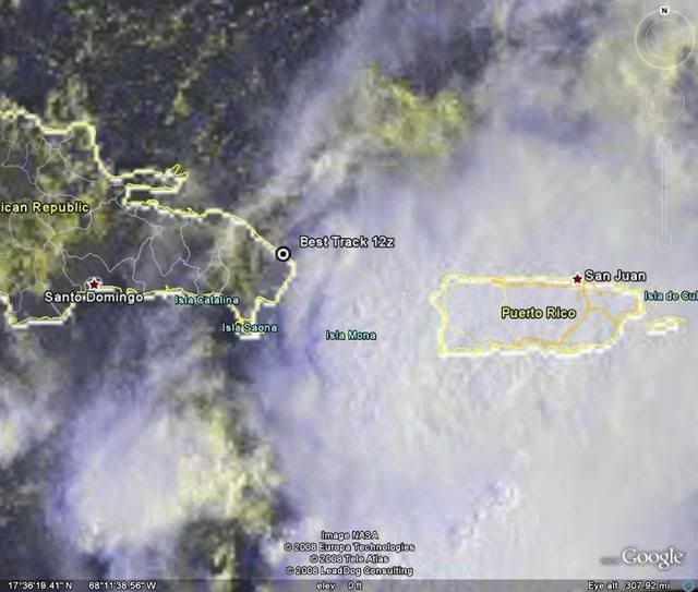
Best Track 12z:

AL, 93, 2008092212, , BEST, 0, 187N, 684W, 30, 1010,


Image
0 likes   

User avatar
TampaFl
S2K Supporter
S2K Supporter
Posts: 1904
Age: 67
Joined: Thu Sep 04, 2003 11:23 am
Location: Tampa, FL

Re: ATL INVEST 93L: Discussion

#466 Postby TampaFl » Mon Sep 22, 2008 7:59 am

Yes Cycloneeye I was just about to post the Punta Cana radar. It appears that the center is moving west to just south of west. This might change the model outputs, if it survives the mountains, ect. Bottom line still life threathning rains/floods for you. Thoughts& comments welomed.
0 likes   

User avatar
storms in NC
S2K Supporter
S2K Supporter
Posts: 2338
Joined: Thu Jul 28, 2005 2:58 pm
Location: Wallace,NC 40 miles NE of Wilm
Contact:

#467 Postby storms in NC » Mon Sep 22, 2008 8:01 am

One thing I have to say is I am very sorry for everyone down in the Islands this year. They have had it bad and still getting it. I think they had every storm but 2 that sat over them and pounded rain on top of them. Now 93L is doing the same. Out of all the Island have got the worse of it all. Yes Tx got a Strong cat2 that brought in the tidal waves that pounded the coast line. But look how many people have dies in the Islands.
To all of you in the Island I wish you God's speed and pray that it will do no more harm to the Islands.

Now on 93l Not a lot of talk for it. Any think can happen here. It can go into Fl or up the coast or out to sea.
0 likes   

User avatar
wxman57
Moderator-Pro Met
Moderator-Pro Met
Posts: 22979
Age: 67
Joined: Sat Jun 21, 2003 8:06 pm
Location: Houston, TX (southwest)

Re: ATL INVEST 93L: Discussion

#468 Postby wxman57 » Mon Sep 22, 2008 8:07 am

Definitely no LLC on surface obs, not even close. Winds about 10 kts from the ENE-ESE across the eastern DR and PR. Nothing has changed as far as the long-term track. Deepening upper low over GA/SC will result in increasing westerly winds across FL and the Bahamas this week, preventing any movement in that direction. Development chances are by no means certain, as the disturbance will continue to fight wind shear. Shear drops off over the next 2-3 days then should be increasing significantly as it moves north of 30N by Thursday.
0 likes   

User avatar
Lowpressure
S2K Supporter
S2K Supporter
Posts: 2032
Age: 58
Joined: Sun Sep 14, 2003 9:17 am
Location: Charlotte, North Carolina

Re: ATL INVEST 93L: Discussion

#469 Postby Lowpressure » Mon Sep 22, 2008 8:31 am

wxman57 wrote:Definitely no LLC on surface obs, not even close. Winds about 10 kts from the ENE-ESE across the eastern DR and PR. Nothing has changed as far as the long-term track. Deepening upper low over GA/SC will result in increasing westerly winds across FL and the Bahamas this week, preventing any movement in that direction. Development chances are by no means certain, as the disturbance will continue to fight wind shear. Shear drops off over the next 2-3 days then should be increasing significantly as it moves north of 30N by Thursday.

Local discussion mentions how difficult it is to know how the interaction of these two lows will play out. Models showing three scenarios. Even read the Fujiwara effect as one possibility! Do you have any ideas? Do they shunt, does one guide the other, or is it all dependent on the strength of each low?
0 likes   

Ed Mahmoud

Re: ATL INVEST 93L: Discussion

#470 Postby Ed Mahmoud » Mon Sep 22, 2008 8:34 am

JB mentioned his big idea he's been mentioning all season again. Hurricane West of Delaware Bay pushing storm surge into Philadelphia.

Not forecasting that yet, just leaving the possibility open.
0 likes   

User avatar
HURAKAN
Professional-Met
Professional-Met
Posts: 46086
Age: 38
Joined: Thu May 20, 2004 4:34 pm
Location: Key West, FL
Contact:

Re: ATL INVEST 93L: Discussion

#471 Postby HURAKAN » Mon Sep 22, 2008 8:39 am

Image
0 likes   

User avatar
HURAKAN
Professional-Met
Professional-Met
Posts: 46086
Age: 38
Joined: Thu May 20, 2004 4:34 pm
Location: Key West, FL
Contact:

#472 Postby HURAKAN » Mon Sep 22, 2008 8:45 am

22/1145 UTC 18.3N 67.5W T1.5/2.0 93L

Image
0 likes   

User avatar
caribepr
Category 5
Category 5
Posts: 1794
Joined: Fri Sep 05, 2003 10:43 pm
Location: Culebra, PR 18.33 65.33

#473 Postby caribepr » Mon Sep 22, 2008 8:56 am

Thanks for the Cana radar shot, Luis. I'm amazed our radar lasted as long as it did...it was still working up to about 4 a.m. when I finally really went to sleep for a few hours.
0 likes   

User avatar
HURAKAN
Professional-Met
Professional-Met
Posts: 46086
Age: 38
Joined: Thu May 20, 2004 4:34 pm
Location: Key West, FL
Contact:

#474 Postby HURAKAN » Mon Sep 22, 2008 9:02 am

716
TCCA22 KNHC 221319
STDCCA

SATELLITE TROPICAL DISTURBANCE RAINFALL ESTIMATES
NWS TPC/NATIONAL HURRICANE CENTER MIAMI FL
1245 UTC MON SEP 22 2008


SYSTEM NAME/IDENTIFIER...AL932008

MAX RAINFALL
DATE/TIME LOCATION MOTION MEAN LAST
----------- ------------ ------ ------- -------
22/1215 UTC 18.7N 68.4W 300/04 24.2 IN 14.1 IN


LAST RAINFALL DISTRIBUTION...

DISTANCE LEFT OF CENTER RIGHT OF CENTER
------------- --------------- ---------------
0 TO 1 DEGREE 10.8 TO 14.1 IN 4.8 TO 9.9 IN
1 TO 2 DEGREE 2.8 TO 12.7 IN 0.0 TO 4.8 IN
2 TO 3 DEGREE 1.5 TO 3.3 IN 0.0 TO 0.0 IN
3 TO 4 DEGREE 0.0 TO 2.0 IN 0.0 TO 0.0 IN


...LEGEND...

SYSTEM NAME/IDENTIFIER...NAME OR NUMBER ASSIGNED TO SYSTEM
(E.G. TROPICAL STORM ALPHA, TROPICAL
DISTURBANCE 01, SURFACE TROUGH)

DATE/TIME... DAY OF MONTH AND TIME IN UNIVERSAL TIME
COORDINATES (UTC) IN A DY/HRMN FORMAT

LOCATION... ESTIMATED CENTER OF SYSTEM OR ADVISORY
POSITION FOR TROPICAL CYCLONE IN TENTHS
OF DEGREES OF LATITUDE AND LONGITUDE

MOTION... ESTIMATED DIRECTION AND SPEED OF SYSTEM
IN DEGREES AND KNOTS

MEAN MAXIMUM RAINFALL... THE 24-HOUR MEAN MAXIMUM ACCUMULATION OF
RAINFALL FOR THE SYSTEM IN INCHES BASED
ON FOUR SATELLITE IMAGES SIX HOURS APART

LAST MAXIMUM RAINFALL... THE MAXIMUM ACCUMULATION OF RAINFALL FOR
THE SYSTEM IN INCHES BASED ON THE MOST
RECENT SATELLITE IMAGE

RAINFALL DISTRIBUTION... THE DISTRIBUTION OF RAINFALL WITHIN FOUR
DEGREES (240 NM) LEFT AND RIGHT OF THE
SYSTEM CENTER IN ONE DEGREE (60NM)
INCREMENTS...LOOKING DOWNSTREAM
(1 IN = 25.4 MM)


NNNN
0 likes   

User avatar
boca
Category 5
Category 5
Posts: 6367
Age: 60
Joined: Mon Dec 15, 2003 8:49 am
Location: Boca Raton,FL

Re: ATL INVEST 93L: Discussion

#475 Postby boca » Mon Sep 22, 2008 9:04 am

It looks like 93L is moving slowly WSW towards Hispanola.Hopefully with taht low forecast to develop off the Carolinas will notch 93L finally northward away from the islands.Good luck down there.
0 likes   

User avatar
cycloneye
Admin
Admin
Posts: 145322
Age: 68
Joined: Thu Oct 10, 2002 10:54 am
Location: San Juan, Puerto Rico

Re: ATL INVEST 93L: Discussion

#476 Postby cycloneye » Mon Sep 22, 2008 9:11 am

This graphic of total precipitation so far tells the story here.The most affected areas has been the South ,SE and Eastern Puerto Rico.I will post much more information later today,but I will only say for now that Patillas in SE PR recieved in 24 hours,24.46 inches of rain.The number of deaths keeps climbing,now 4 deaths related to this event.More later.

Image
0 likes   

User avatar
bvigal
S2K Supporter
S2K Supporter
Posts: 2276
Joined: Sun Jul 24, 2005 8:49 am
Location: British Virgin Islands
Contact:

Re: ATL INVEST 93L: Discussion

#477 Postby bvigal » Mon Sep 22, 2008 9:11 am

rainfall amounts per NWS-SJU:
000
FXCA62 TJSJ 221011
AFDSJU

AREA FORECAST DISCUSSION
NATIONAL WEATHER SERVICE SAN JUAN PR
611 AM AST MON SEP 22 2008

.SYNOPSIS...AT UPPER LEVELS...WEAK LOW PRESSURE AND LIGHT WINDS WILL SLOWLY GIVE WAY TO A RIDGE BUILDING FROM THE SOUTHEAST THURSDAY. HIGH PRESSURE OVER THE LOCAL AREA WILL BE REPLACED BY A VIGOROUS LOW ALSO FROM THE SOUTHEAST BY THE FOLLOWING MONDAY. AT MID LEVELS...A WEAK LOW PRESSURE OVER PUERTO RICO WILL DRIFT NEARLY NORTH ALONG 70 WEST WHILE HIGH PRESSURE BUILDS IN FROM THE NORTHEAST. A WEAK INVERTED TROUGH WILL MOVE FROM THE EAST OVER THE LOCAL AREA OVER THE WEEKEND AND HIGH PRESSURE WILL MOVE NORTHWARD INTO THE ADJACENT ATLANTIC. HIGH PRESSURE WILL THEN DOMINATE THE WESTERN ATLANTIC TO THE COAST OF AFRICA NEXT WEEK. EXTENSIVE MOISTURE AT MID LEVELS WILL LEAVE THE AREA ON WEDNESDAY FOLLOWING THE LOW PRESSURE.

AT LOWER LEVELS...LOW PRESSURE EMBEDDED IN A TROPICAL WAVE IS BRINGING VAST QUANTITIES OF MOISTURE TO THE LOCAL AREA... PRINCIPALLY ON THE EAST SIDE OF THE TROPICAL WAVE AXIS WHICH STRETCHES NORTHEAST-SOUTHWEST ACROSS THE MONA PASSAGE. THIS LOW IS EXPECTED TO DEVELOP SLOWLY AND MOVE NORTH NORTHWEST AT FIRST AND THEN NORTH ALONG THE 70TH MERIDIAN THROUGH SATURDAY. MOIST SOUTHEAST FLOW WILL CONTINUE AT LOWER LEVELS UNTIL THURSDAY. AT WHICH TIME A RIDGE OF HIGH PRESSURE TO THE NORTH WILL CAUSE FLOW TO BECOME MORE EAST NORTHEAST UNTIL NEXT WEEK.

&&

.DISCUSSION...MOISTURE CONTINUES TO STREAM NORTH OVER PUERTO RICO...VIEQUES AND CULEBRA. THE U.S. VIRGIN ISLANDS REMAIN ON THE FRINGE AS THE BAND OF MOISTURE MOVES VERY SLOWLY TO THE WEST. ]STORM TOTAL RAINFALL AMOUNTS HAVE EXCEEDED 20 TO 30 INCHES IN PARTS OF SOUTHEAST PUERTO RICO WHERE RIVERS ARE WELL ABOVE FLOOD STAGE. BANDS OF THUNDERSTORMS WERE NOTED OVER AND WEST OF SOUTHERN YAUCO TO CABO ROJO WITH TOPS IN EXCESS OF 50 THOUSAND FEET. TOPS IN EXCESS OF 60 TO 70 THOUSAND FEET WERE NOTED SOUTH OF THE FORECAST AREA. THESE AREAS ARE MOVING VERY LITTLE. AS SOLAR HEATING INCREASES EXPECT MORE CONVECTION TO SPREAD ACROSS MOST OF THE FORECAST AREA...MAINLY WEST OF THE U.S. VIRGIN ISLANDS. HEAVIER RAINS ARE ALSO LIKELY TO BE EXPERIENCED IN THE NORTHWEST WHERE LITTLE PRECIPITATION HAS FALLEN AS OF NOW...AND IN THE AREAS NORTH OF THE CORDILLERA CENTRAL. BECAUSE THIS SYSTEM IS MOVING SO SLOWLY THE POTENTIAL FOR FLOODING IS VERY HIGH AND THAT FLOODING WILL BE...AND INDEED ALREADY IS...MORE SERIOUS THAN ANY THAT HAS OCCURRED IN RECENT MEMORY. FOR THE EARLY PART OF THE MORNING HOWEVER...EXPECT THE WORST FLOODING TO BE IN SOUTHWEST PUERTO RICO... ALTHOUGH FLOOD WATERS FROM PREVIOUS RAINS IN SOUTHEAST PUERTO RICO WILL ALSO BE SEVERE.

SHOWERS AND THUNDERSTORMS WILL DIMINISH SLOWLY TONIGHT AND TOMORROW...BUT WILL BE SCATTERED THROUGH THE AREA AT LEAST THROUGH WEDNESDAY. 10 TO 20 INCHES ARE EXPECTED IN PARTS OF CENTRAL AND WESTERN SECTIONS OF PUERTO RICO TODAY THROUGH TONIGHT. EXPECT THAT THE FLASH FLOOD WATCH WILL BE DROPPED LATER THIS MORNING FOR THE U.S. VIRGIN ISLANDS AS THE FOCUS OF CONVECTION SHIFTS WESTWARD.

TEMPERATURES WILL BE MODERATE TODAY...DESPITE SOUTH FLOW DUE TO RAIN AND CLOUDS. HAVE LOWERED MAX TEMPS SEVERAL DEGREES. YESTERDAY'S HIGH IN SAN JUAN WAS ONLY 81...BUT BREAKS MAY ALLOW WARMER TEMPERATURES TODAY.

&&

.AVIATION...CONSIDERABLE CLOUDINESS WILL COVER THE LOCAL FLYING AREA TODAY AS AN ELONGATED AREA OF DISTURBED WEATHER ASSOCIATED WITH A STRONG TROPICAL WAVE CONTINUES TO AFFECT THE LOCAL REGION AT LEAST THROUGH TONIGHT. THE MAIN AXIS OF ACTIVITY EXTENDED NORTHWARD FROM THE SOUTHERN CARIBBEAN ACROSS PORTIONS OF SOUTHWESTERN AND SOUTH CENTRAL PUERTO RICO AND THE U.S. VIRGIN ISLANDS THIS MORNING. EXPECT MAINLY MVFR CONDITIONS ACROSS MOST TAF SITES DURING THE MORNING HOURS WITH EXTENSIVE MOUNTAIN OBSCURATIONS. TJPS MAY EXPERIENCE BRIEF PERIODS OF IFR CONDITIONS IN HEAVY SHOWERS AND STRONG THUNDERSTORMS FROM 10-14Z. TJBQ WILL EXPERIENCE MAINLY VFR CONDITIONS FROM 10-16Z...WITH BRIEF PERIODS OF MVFR CONDITIONS AFTER 16Z. VFR CONDITIONS WILL PREDOMINATE IN THE U.S. VIRGIN ISLANDS AND EASTERN LEEWARDS. WOULD EXPECT HEAVY ICING ABOVE THE FREEZING LEVEL AT 15 THOUSAND FEET.

&&

.MARINE...BANDS OF THUNDERSTORMS CONTINUE TO MOVE ACROSS THE CARIBBEAN AND INTO PUERTO RICO. SOME OF THESE MAY CONTAIN WATERSPOUTS. SEVERAL TVS SIGNATURES WERE SEEN EARLIER THIS MORNING ON NATIONAL WEATHER SERVICE DOPPLER RADAR AND SOME TRANSIENT MESO CYCLONES ALSO APPEAR. SEAS...FROM BUOY OBSERVATIONS...HAVE NOT RISEN AS MUCH AS EXPECTED BECAUSE THE SYSTEM HAS BEEN VERY SLOW TO DEVELOP. THEREFORE THE HIGH SURF ADVISORY HAS BEEN DROPPED AND THE WAVE HEIGHT FORECAST HAS BEEN LOWERED. NEVERTHELESS WAVES AT BUOY 41043 NORTH OF SAINT THOMAS HAVE BEEN APPROACHING 7 FEET EVEN THOUGH WINDS REMAIN BELOW 20 KNOTS FOR THE TIME BEING. WINDS ELSEWHERE IN THE AREA...EXCEPT IN THE IMMEDIATE VICINITY OF STRONG THUNDERSTORMS...HAVE BEEN LESS THAN THIS. MARINERS SHOULD BE VIGILANT...ESPECIALLY IN THE ATLANTIC WATERS...FOR THE POTENTIAL DEVELOPMENT OF THIS SYSTEM AND BE READY TO SEEK SAFE HARBOR. GUSTY WINDS WILL BE ENCOUNTERED NEAR THUNDERSTORMS AND GUSTS COULD EXCEED 35 KNOTS IN VERY LOCAL AREAS.

&&

.HYDROLOGY...AT 6 AM AST SOME RIVERS ACROSS SOUTHEAST AND SOUTHERN PUERTO RICO WERE AS MUCH AS 14 FEET ABOVE FLOOD LEVEL...ALTHOUGH SOME OF THESE ARE GOING DOWN. SOME HOWEVER ARE STILL RISING... ESPECIALLY IN THE SOUTHWEST WHERE THE HEAVIEST RAINS WERE OCCURRING AT THE MOMENT. ALL OF PUERTO RICO IS STILL SUBJECT TO FLASH FLOODING...AND FLOODING WILL LIKELY OCCUR IN AREAS WHERE NONE HAS OCCURRED SO FAR...NAMELY THE NORTH CENTRAL AND NORTHWEST SECTIONS OF PUERTO RICO LATER THIS MORNING AND THIS AFTERNOON.

CURRENTLY RIO PORTUGUES...RIO GUAYANILLA... RIO GUANAJIBO...RIO GRANDE DE ARECIBO...RIO CERRILLOS...RIO INABON... RIO GURABO... RIO MARIN...RIO MAUNABO...RIO GUAYANES AND RIO GRANDE DE LOIZA ARE ALL IN FLOOD AT SOME POINT. AS RAINS CONTINUE TO SPREAD NORTH...FEW OF THESE RIVERS WILL RETURN BELOW FLOOD STAGE SOON.
&&
.PRELIMINARY POINT TEMPS/POPS...
SJU 86 77 88 77 / 100 80 80 30
STT 85 78 87 78 / 90 60 60 30
&&
.SJU WATCHES/WARNINGS/ADVISORIES...
PR...FLASH FLOOD WATCH THROUGH THIS EVENING FOR ALL OF PUERTO RICO.
SCA...AMZ710>730.
VI...FLASH FLOOD WATCH UNTIL 7 AM AST FOR U.S. VIRGIN ISLANDS.
SCA...AMZ710>730.
&&
$$
71/12/
0 likes   

User avatar
gatorcane
S2K Supporter
S2K Supporter
Posts: 23691
Age: 47
Joined: Sun Mar 13, 2005 3:54 pm
Location: Boca Raton, FL

Re: ATL INVEST 93L: Discussion

#478 Postby gatorcane » Mon Sep 22, 2008 9:20 am

boca wrote:It looks like 93L is moving slowly WSW towards Hispanola.Hopefully with taht low forecast to develop off the Carolinas will notch 93L finally northward away from the islands.Good luck down there.


certainly looks to be drifting WSW now...as I said yesterday, I am not convinced with the models with a slow north drift, then north east of the CONUS, sorry.

May not be wise to put much stock in those models just yet.

If it manages to get tho Haiti, this is the last thing it needs.
0 likes   

User avatar
gatorcane
S2K Supporter
S2K Supporter
Posts: 23691
Age: 47
Joined: Sun Mar 13, 2005 3:54 pm
Location: Boca Raton, FL

#479 Postby gatorcane » Mon Sep 22, 2008 9:32 am

To me this looks like a strong tropical wave now drifting west or WNW through the Caribbean. Since it shallow I don't see any northward movement.

It was a bit deeper yesterday so was feeling the weakness in the western atlantic subtropical ridge.....there is a LARGE break in that ridge at the moment.
Last edited by gatorcane on Mon Sep 22, 2008 9:33 am, edited 3 times in total.
0 likes   

User avatar
boca
Category 5
Category 5
Posts: 6367
Age: 60
Joined: Mon Dec 15, 2003 8:49 am
Location: Boca Raton,FL

Re: ATL INVEST 93L: Discussion

#480 Postby boca » Mon Sep 22, 2008 9:32 am

I look at the models and use them as a guide to forecasting,but when I see 93L moving slowly WSW that has me concerned for Hispanola/Haiti area. They don't need this storm. Maybe theirs a chance that the models could be off and 93L might drift further west then make that turn northward.Another issue is the models are basing that north motion and a low developing off the Carolinas. What happens if the low doesn't develop.Models can be wrong too.
0 likes   


Return to “2008”

Who is online

Users browsing this forum: No registered users and 4 guests