HurricaneFreak wrote:Okay Invest 93 is going to be a fish storm because the models keep on moving slightly east.And if it intensifies it should only be a tropical storm or depression and become subtropical when it moves more north.
That may be premature, and the leftover mid/upper feature from 94L may try to bend it back in.
GFDL at 18Z is still aiming for Cape Cod, not far from earlier runs, as a minimal Cat 1. Granted, this should be 1001 mb with winds over 50 knots right now, per GFDL 6 hour forecast. Extrap pressure, 997 mb, is actually a touch below that, but no recon winds that strong.
But a high end tropical storm, possibly with some added juice from non-tropical processes, into Eastern New England or Canada can't be ruled out. If this develops, which, indeed, may not happen.
That isn't a forecast, just an opinion, and I am an amateur.ETA:
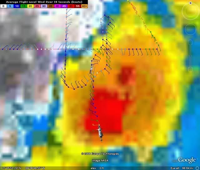
000200 2115N 06916W 7611 02406 0046 +133 +119 323007 008 034 000 03
000230 2116N 06914W 7614 02404 0045 +134 +129 306006 010 044 007 00
000300 2118N 06913W 7610 02409 0040 +132 +132 217002 005 046 008 00
000330 2119N 06911W 7581 02440 0015 +128 +128 148005 010 040 002 00
000400 2120N 06909W 7571 02454 9983 +129 +129 132014 015 040 003 00
000430 2122N 06908W 7574 02453 9970 +130 +130 130014 015 999 999 03
000500 2124N 06908W 7580 02444 0047 +133 +127 146018 018 036 002 00
000530 2126N 06908W 7597 02427 0051 +131 +126 141016 017 033 000 03
That 997 looks a little funky to me.