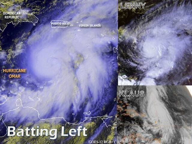
ATL OMAR: Remnant Low - Discussion
Moderator: S2k Moderators
-
HURAKAN

- Professional-Met

- Posts: 46084
- Age: 39
- Joined: Thu May 20, 2004 4:34 pm
- Location: Key West, FL
- Contact:
Re: ATL OMAR: Hurricane - Discussion
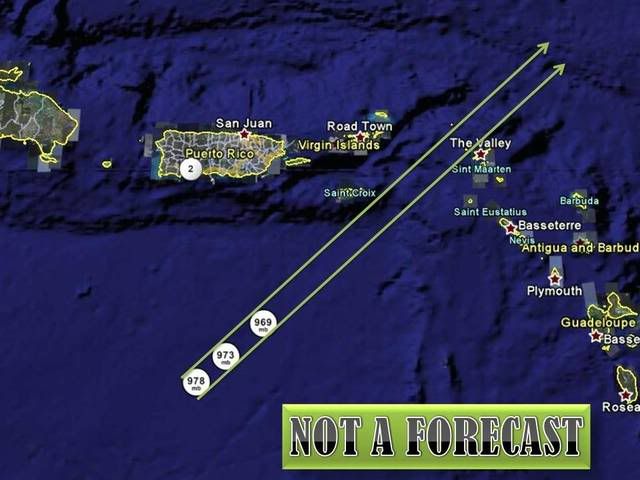
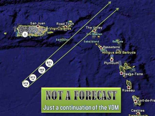
Not a forecast, just an imaginary continuation of the past three VDA. Cyclones do not move in a straight line.
0 likes

Re: ATL OMAR: Hurricane - Discussion
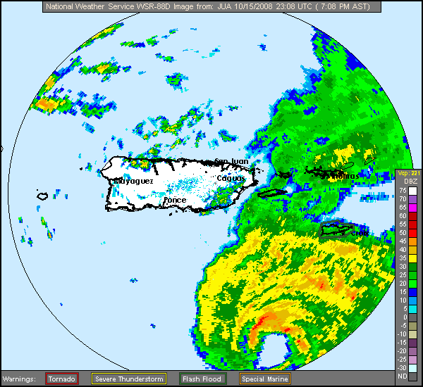
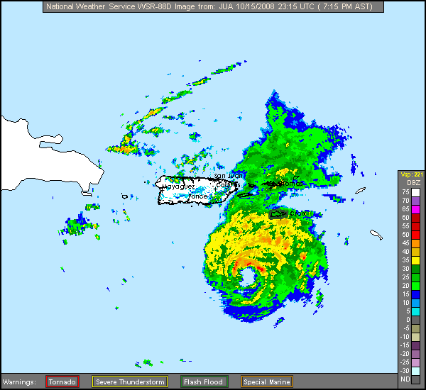
looking at the radar the eye seems to take a more Northenly path at the end. Does anybody see that?
http://radar.weather.gov/ridge/radar.ph ... 1&loop=yes
http://radar.weather.gov/ridge/radar.ph ... 1&loop=yes
0 likes
Re: ATL OMAR: Hurricane - Discussion
Looking close to a fairly wide east side pass of St Croix and hard side pass of Anguilla and through the Anegada Passage.
The eye is clearly tightening up on radar. Get ready.
The eye is clearly tightening up on radar. Get ready.
The posts in this forum are NOT official forecast and should not be used as such. They are just the opinion of the poster and may or may not be backed by sound meteorological data. They are NOT endorsed by any professional institution or storm2k.org. For official information, please refer to the NHC and NWS products.
0 likes

Re: ATL OMAR: Hurricane - Discussion
Could we luck out with the hurricane force winds...or at least the eye wall...sneaking between the passage between St. Martin and the US & British VI?
Large parts of Puerto Rico might even miss out on the ts winds if the current heading holds....

Large parts of Puerto Rico might even miss out on the ts winds if the current heading holds....
0 likes
-
wxman57

- Moderator-Pro Met

- Posts: 23172
- Age: 68
- Joined: Sat Jun 21, 2003 8:06 pm
- Location: Houston, TX (southwest)
Re: ATL OMAR: Hurricane - Discussion
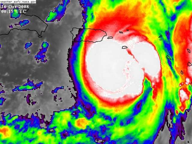
It appears to be heading right for St. Croix now, maybe the eastern side of the island. Bad news is that the latest HRD wind analysis (2230Z) now has 64kt winds extending 25-30 miles from the center and the hurricane-force wind area is expanding significantly:
http://www.aoml.noaa.gov/hrd/Storm_page ... /wind.html
http://www.aoml.noaa.gov/hrd/Storm_page ... /wind.html
0 likes
-
MiamiensisWx
Latest HRD gridded H*WIND analysis for brevity:
ftp://ftp.aoml.noaa.gov/hrd/pub/hwind/2008/AL152008/1015/2230/AL152008_1015_2230_contour04.png
ftp://ftp.aoml.noaa.gov/hrd/pub/hwind/2008/AL152008/1015/2230/AL152008_1015_2230_contour04.png
0 likes
-
Gustywind

- Category 5

- Posts: 12334
- Joined: Mon Sep 03, 2007 7:29 am
- Location: Baie-Mahault, GUADELOUPE
Re: ATL OMAR: Hurricane - Discussion
jinftl wrote:Could we luck out with the hurricane force winds...or at least the eye wall...sneaking between the passage between St. Martin and the US & British VI?
Sneaking between the passage between St. Martin and the US & British VI or NOT we have a cat 2 cane very close to 3 in vicinity of the BVI, and the others Leewards. I sincerely appreciate your interrest of the details, but for the moment others things are much important than that, (you dont' tkink that
So knowing if Omar will pass between St. Martin and the US & British VI...is not the most important with my untrained eyes , if Omar could be nothing more than a cat 2 i will HONESTLY appreciate jinft, tkanks a lot for all , just a wish pray for us in the Leewards
0 likes
-
MiamiensisWx
Re: ATL OMAR: Hurricane - Discussion
Gustywind wrote:jinftl wrote:Could we luck out with the hurricane force winds...or at least the eye wall...sneaking between the passage between St. Martin and the US & British VI?
Sneaking between the passage between St. Martin and the US & British VI or NOT we have a cat 2 cane very close to 3 in vicinity of the BVI, and the others Leewards. I sincerely appreciate your interrest of the details, but for the moment others things are much important than that, (you dont' tkink that) because worst weather conditions are expected.
So knowing if Omar will pass between St. Martin and the US & British VI...is not the most important with my untrained eyes , if Omar could be nothing more than a cat 2 i will HONESTLY appreciate jinft, tkanks a lot for all , just a wish pray for us in the Leewards especially the BVI and the Northern Leewards ( St Marteen and St Barth graciasss)!!!
Since the TC will not be interacting with a boundary or the baroclinic region slightly farther north, it is probable that the radius of hurricane force winds will only slowly increase in size (areal coverage) over the next 24 hours. Therefore, JinFTL's point is valid. A small variation in the heading and track will make a significant difference for Sint Maarten, Saint Croix, and other areas, since the strongest winds will be occurring east of the center (due to the forward speed and synoptic/thermodynamic set-up). Secondly, true Category 1/2 (or even very strong TS winds) are much stronger than some people may suspect... take it from my experience, since I encountered marginal Category 1 conditions during Wilma in southeastern Florida.
This event (for what it's worth) will likely be the strongest TC to impact the northern Leeward Islands since Georges 1998 and Lenny 1999.
Last edited by MiamiensisWx on Wed Oct 15, 2008 7:36 pm, edited 1 time in total.
0 likes


Re: ATL OMAR: Hurricane - Discussion
You've got my prayers and good thoughts in abundance...for all of those who are in the path...and those who are close enough to the path to be rightfully concerned.....sincerely sending well wishes to each and everyone of you...may the light of dawn reveal a landscape and people untouched and as beautiful as ever
Gustywind wrote:jinftl wrote:Could we luck out with the hurricane force winds...or at least the eye wall...sneaking between the passage between St. Martin and the US & British VI?
Sneaking between the passage between St. Martin and the US & British VI or NOT we have a cat 2 cane very close to 3 in vicinity of the BVI, and the others Leewards. I sincerely appreciate your interrest of the details, but for the moment others things are much important than that, (you dont' tkink that) because worst weather conditions are expected.
So knowing if Omar will pass between St. Martin and the US & British VI...is not the most important with my untrained eyes , if Omar could be nothing more than a cat 2 i will HONESTLY appreciate jinft, tkanks a lot for all , just a wish pray for us in the Leewardsespecially the BVI and the Northern Leewards ( St Marteen and St Barth graciasss
0 likes
Who is online
Users browsing this forum: No registered users and 81 guests