Tampa Bay Hurricane wrote:Hopefully shear weakens it...so it has mercy on those in its path.
If shear is strong enough it can keep this at 110 mph or below...
but this really bears watching for islands of the caribbean
There is essentially no difference between 95 kt/110 mph and a major hurricane. Category 2 intensity is still very intense...
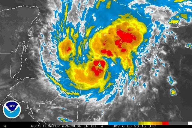
I strongly believe Paloma will attain major hurricane intensity. Satellite data (and AMSUB/microwave imagery) has been revealing the presence of a relatively small inner core. Upper level analysis reveals a textbook dual outflow pattern, with a southwesterly upper level jet on the NW quadrant and northwesterly wind vectors on the eastern flank of an established 250-300 mb UL anticyclone. Divergence is excellent to outstanding at all levels, as is low level convergence. Westerly wind vectors southwest of a deep upper low over the central North Atlantic (and the cutoff low/coastal storm near the Carolinas) is also aiding the well defined poleward outflow channel. The synoptic pattern and Paloma's position on the southwestern flank of the UL anticyclone is a classical situation for rapid intensification to major hurricane intensity, especially with the small inner core and developing CDO. The 12Z 500 mb analysis reveals that height contours are higher than progged by the 06Z operational GFS over the Southeast, in accordance with the deeper, more amplified upper level trough over the Plains. This factor and the TC's earlier turn will likely negate the effects of shear from the approaching trough and the associated jet maximum. Overall, this scenario is slightly reminescent of Omar, since the TC's angle of approach (in relation to the heading of the strengthening upper level wind vectors) will likely mitigate the upper level shear.
The only negative factor inhibiting greater intensification of Paloma is the convection northeast of the inner core, which has been hindering greater low level inflow. The convection has been induced by the strong ascent in the vicinity, which is producing a lifting mechanism. However, very recent GOES satellite imagery reveals that new adjacent convection is developing closer to the center, as the inner core approaches the region of greatest forced ascent. Additionally, the convection appears to be "merging" with the developing CDO. It is probable that this will finally aid low level inflow to the inner core, especially as the convection farther northeast diminishes overnight. The spectre of rapid intensification is also raised by the steepening lapse rates overnight and cool mid level temperatures, which are typically cooler later in the season, aiding the formation of deeper convection.
I have always believed the initial intensity forecasts for the Cuban landfall of Paloma were underestimated, based on the preceding data and the fact that the acceleration in speed will reduce shear on the back side (a la Charley, Wilma, etc.). It is also noted that Michelle 2001 (if I recall correctly) was originally forecasted to weaken to a marginal major hurricane (~100-105 kt?) prior to Cuban landfall, based on some early model guidance/intensity forecasts, which misjudged some aspects of the upper level pattern.
Interestingly, the higher heights to the northwest and the system's earlier turn raises the possibility of a brief reduction in forward speed near the Cayman Islands as the trough approaches, followed by another acceleration toward Cuba. I feel that the Caymans could experience the strongest hit since Ivan 2004, and the TC will likely (in my view) be ~100 kt as it traverses the vicinity of the islands. It's quite possible that this estimate could be conservative as well. I believe the Cuban landfall intensity may be Category 2 intensity, followed by rapid weakening and a very quick transition to an extratropical (baroclinic) system over the southern Bahamas/TCI as it interacts with the strong westerlies.