Tornado outbreak - February 10-11, 8+ dead

U.S. & Caribbean Weather Discussions and Severe Weather Events

Moderator: S2k Moderators

Forum rules

The posts in this forum are NOT official forecast and should not be used as such. They are just the opinion of the poster and may or may not be backed by sound meteorological data. They are NOT endorsed by any professional institution or STORM2K.

Help Support Storm2K
Message
Author
RL3AO
Moderator-Pro Met
Moderator-Pro Met
Posts: 16308
Joined: Thu Jun 14, 2007 10:03 pm
Location: NC

#261 Postby RL3AO » Tue Feb 10, 2009 4:57 pm

Could get interesting in the more moist air if this dry line decides to move today.
0 likes   

User avatar
jasons2k
Storm2k Executive
Storm2k Executive
Posts: 8245
Age: 51
Joined: Wed Jul 06, 2005 12:32 pm
Location: The Woodlands, TX

#262 Postby jasons2k » Tue Feb 10, 2009 5:00 pm

Let's please cut down on the chat and what we would have done or not done if we worked at the SPC.

PDS watches are very rare for a reason.

Let's keep the discussion on the weather please - thanks.
0 likes   

CrazyC83
Professional-Met
Professional-Met
Posts: 34002
Joined: Tue Mar 07, 2006 11:57 pm
Location: Deep South, for the first time!

#263 Postby CrazyC83 » Tue Feb 10, 2009 5:00 pm

The slow dryline is allowing even more warm air in?
0 likes   

RL3AO
Moderator-Pro Met
Moderator-Pro Met
Posts: 16308
Joined: Thu Jun 14, 2007 10:03 pm
Location: NC

#264 Postby RL3AO » Tue Feb 10, 2009 5:03 pm

0353 PM HAIL GUTHRIE 35.88N 97.42W
02/10/2009 E2.75 INCH LOGAN OK BROADCAST MEDIA

REPORTED BY KFOR TV
0 likes   

CrazyC83
Professional-Met
Professional-Met
Posts: 34002
Joined: Tue Mar 07, 2006 11:57 pm
Location: Deep South, for the first time!

#265 Postby CrazyC83 » Tue Feb 10, 2009 5:05 pm

It does seem that discrete cells are really getting going in eastern Oklahoma as well. I'm not sure where that would be covered from though.
0 likes   

User avatar
Dave
Retired Staff
Retired Staff
Posts: 13442
Age: 74
Joined: Tue Aug 01, 2006 3:57 pm
Location: Milan Indiana
Contact:

#266 Postby Dave » Tue Feb 10, 2009 5:09 pm

I'm on the Ft Smith AR radar with GRL3..covering eastern OK.
0 likes   

CrazyC83
Professional-Met
Professional-Met
Posts: 34002
Joined: Tue Mar 07, 2006 11:57 pm
Location: Deep South, for the first time!

#267 Postby CrazyC83 » Tue Feb 10, 2009 5:11 pm

Storm 4 looks really impressive now.
0 likes   

RL3AO
Moderator-Pro Met
Moderator-Pro Met
Posts: 16308
Joined: Thu Jun 14, 2007 10:03 pm
Location: NC

#268 Postby RL3AO » Tue Feb 10, 2009 5:11 pm

Heres a quick drawing. Cold front is catching up to the dry line.

Image
0 likes   

RL3AO
Moderator-Pro Met
Moderator-Pro Met
Posts: 16308
Joined: Thu Jun 14, 2007 10:03 pm
Location: NC

#269 Postby RL3AO » Tue Feb 10, 2009 5:19 pm

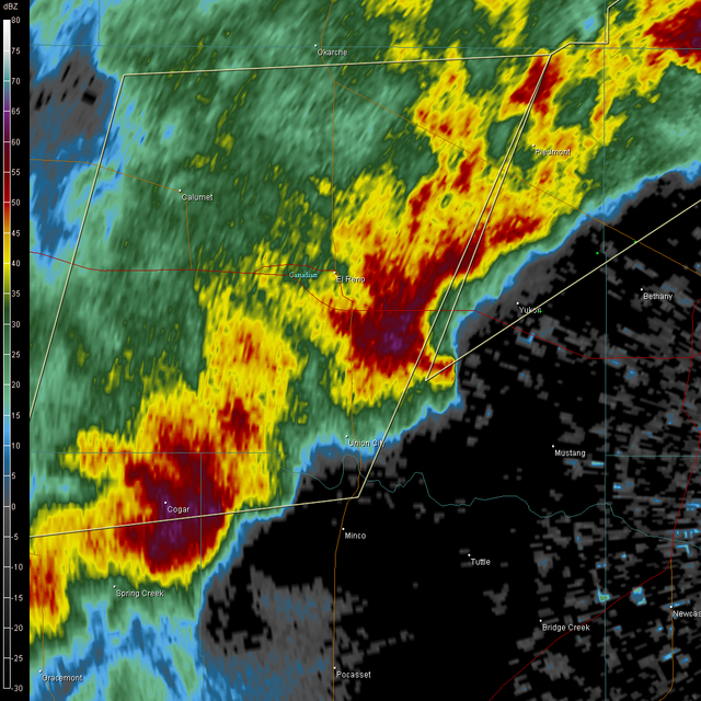
Image

Cell near Yukon looking better.
0 likes   

CrazyC83
Professional-Met
Professional-Met
Posts: 34002
Joined: Tue Mar 07, 2006 11:57 pm
Location: Deep South, for the first time!

#270 Postby CrazyC83 » Tue Feb 10, 2009 5:30 pm

The cell near Guthrie developed in a hurry! It really has a big couplet now...
0 likes   

User avatar
Bunkertor
Category 5
Category 5
Posts: 3397
Joined: Tue May 09, 2006 3:48 pm

#271 Postby Bunkertor » Tue Feb 10, 2009 5:31 pm

What could happen when the coldfront overtakes the line ?
0 likes   

RL3AO
Moderator-Pro Met
Moderator-Pro Met
Posts: 16308
Joined: Thu Jun 14, 2007 10:03 pm
Location: NC

Re:

#272 Postby RL3AO » Tue Feb 10, 2009 5:33 pm

Bunkertor wrote:What could happen when the coldfront overtakes the line ?


Might improve the lift some.
0 likes   

RL3AO
Moderator-Pro Met
Moderator-Pro Met
Posts: 16308
Joined: Thu Jun 14, 2007 10:03 pm
Location: NC

#273 Postby RL3AO » Tue Feb 10, 2009 5:37 pm

New TOR on the first cell thats now in Tulsa AOR.

BULLETIN - EAS ACTIVATION REQUESTED
TORNADO WARNING
NATIONAL WEATHER SERVICE TULSA OK
435 PM CST TUE FEB 10 2009

THE NATIONAL WEATHER SERVICE IN TULSA HAS ISSUED A

* TORNADO WARNING FOR...
WESTERN OSAGE COUNTY IN NORTHEAST OKLAHOMA
PAWNEE COUNTY IN NORTHEAST OKLAHOMA

* UNTIL 500 PM CST

* AT 433 PM CST...NATIONAL WEATHER SERVICE DOPPLER RADAR INDICATED A
SEVERE THUNDERSTORM CAPABLE OF PRODUCING A TORNADO 5 MILES
SOUTHWEST OF PAWNEE...MOVING NORTHEAST AT 35 MPH.

* SOME LOCATIONS NEAR THE PATH OF THIS STORM INCLUDE...PAWNEE...
SKEDEE...RALSTON AND FAIRFAX.
0 likes   

CrazyC83
Professional-Met
Professional-Met
Posts: 34002
Joined: Tue Mar 07, 2006 11:57 pm
Location: Deep South, for the first time!

#274 Postby CrazyC83 » Tue Feb 10, 2009 5:39 pm

There is still a big unknown as mentioned on KOCO - what happens when the storms go southeast? The conditions in the path of the training supercells so far have been quite marginal...
0 likes   

User avatar
Bunkertor
Category 5
Category 5
Posts: 3397
Joined: Tue May 09, 2006 3:48 pm

Re: Re:

#275 Postby Bunkertor » Tue Feb 10, 2009 5:40 pm

RL3AO wrote:
Bunkertor wrote:What could happen when the coldfront overtakes the line ?


Might improve the lift some.


Ah, yes. True.
0 likes   

RL3AO
Moderator-Pro Met
Moderator-Pro Met
Posts: 16308
Joined: Thu Jun 14, 2007 10:03 pm
Location: NC

Re:

#276 Postby RL3AO » Tue Feb 10, 2009 5:42 pm

CrazyC83 wrote:There is still a big unknown as mentioned on KOCO - what happens when the storms go southeast? The conditions in the path of the training supercells so far have been quite marginal...


I'm wondering if we are going to get anything to develop ahead of the front/dry line/squall line?
0 likes   

User avatar
Crostorm
Category 5
Category 5
Posts: 2060
Age: 50
Joined: Mon Dec 25, 2006 3:51 pm
Location: Croatia-Europe
Contact:

Re:

#277 Postby Crostorm » Tue Feb 10, 2009 5:43 pm

RL3AO wrote:New TOR on the first cell thats now in Tulsa AOR.

BULLETIN - EAS ACTIVATION REQUESTED
TORNADO WARNING
NATIONAL WEATHER SERVICE TULSA OK
435 PM CST TUE FEB 10 2009

THE NATIONAL WEATHER SERVICE IN TULSA HAS ISSUED A

* TORNADO WARNING FOR...
WESTERN OSAGE COUNTY IN NORTHEAST OKLAHOMA
PAWNEE COUNTY IN NORTHEAST OKLAHOMA

* UNTIL 500 PM CST

* AT 433 PM CST...NATIONAL WEATHER SERVICE DOPPLER RADAR INDICATED A
SEVERE THUNDERSTORM CAPABLE OF PRODUCING A TORNADO 5 MILES
SOUTHWEST OF PAWNEE...MOVING NORTHEAST AT 35 MPH.

* SOME LOCATIONS NEAR THE PATH OF THIS STORM INCLUDE...PAWNEE...
SKEDEE...RALSTON AND FAIRFAX.

Image
0 likes   

CrazyC83
Professional-Met
Professional-Met
Posts: 34002
Joined: Tue Mar 07, 2006 11:57 pm
Location: Deep South, for the first time!

#278 Postby CrazyC83 » Tue Feb 10, 2009 5:43 pm

KOCO: Large lowering in the clouds north of Bethany...rotating quite a bit, might be a tornado warning there soon.
Last edited by CrazyC83 on Tue Feb 10, 2009 5:44 pm, edited 1 time in total.
0 likes   

User avatar
somethingfunny
ChatStaff
ChatStaff
Posts: 3926
Age: 37
Joined: Thu May 31, 2007 10:30 pm
Location: McKinney, Texas

Re:

#279 Postby somethingfunny » Tue Feb 10, 2009 5:44 pm

CrazyC83 wrote:There is still a big unknown as mentioned on KOCO - what happens when the storms go southeast? The conditions in the path of the training supercells so far have been quite marginal...


I don't know but the showers have been quite widespread here across DFW this afternoon. Although the sun got us up to around 70 earlier, right now the rain has cooled us off a bit and the clouds aren't breaking. The main event for DFW may end up being no more than a marginally severe squall line late tonight, unless these showers clear out before sunset.
0 likes   

RL3AO
Moderator-Pro Met
Moderator-Pro Met
Posts: 16308
Joined: Thu Jun 14, 2007 10:03 pm
Location: NC

#280 Postby RL3AO » Tue Feb 10, 2009 5:47 pm

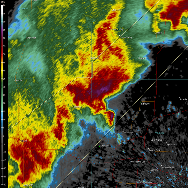
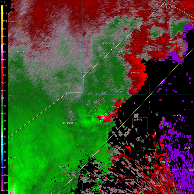
Cell north of Bethany.

Image

Image
0 likes   


Return to “USA & Caribbean Weather”

Who is online

Users browsing this forum: TomballEd and 25 guests