GOM: INVEST 90L

Moderator: S2k Moderators

Message
Author
User avatar
HURAKAN
Professional-Met
Professional-Met
Posts: 46086
Age: 38
Joined: Thu May 20, 2004 4:34 pm
Location: Key West, FL
Contact:

#121 Postby HURAKAN » Mon May 18, 2009 5:48 pm

Image

Image
0 likes   

User avatar
HURAKAN
Professional-Met
Professional-Met
Posts: 46086
Age: 38
Joined: Thu May 20, 2004 4:34 pm
Location: Key West, FL
Contact:

#122 Postby HURAKAN » Mon May 18, 2009 5:50 pm

Image

Bound to get interesting.
0 likes   

User avatar
Tampa Bay Hurricane
Category 5
Category 5
Posts: 5597
Age: 37
Joined: Fri Jul 22, 2005 7:54 pm
Location: St. Petersburg, FL

Re: INVEST 90L North of Cuba

#123 Postby Tampa Bay Hurricane » Mon May 18, 2009 5:58 pm

The SE Gulf Low is the one bringing the very heavy
rain to FL now, in conjunction with the front.
It is starting to get windy here, especially
due to pressure gradient.
Gulf Low has much better concentrated
convection IMO.
0 likes   

jaxfladude
Category 5
Category 5
Posts: 1249
Joined: Wed Aug 24, 2005 9:36 pm
Location: Jacksonville, Fla

#124 Postby jaxfladude » Mon May 18, 2009 6:02 pm

The eastern parts including the beaches of the Jax Metro area is getting wet and windy, and will only get worse as the system(s) do their thing...
0 likes   

User avatar
Tampa Bay Hurricane
Category 5
Category 5
Posts: 5597
Age: 37
Joined: Fri Jul 22, 2005 7:54 pm
Location: St. Petersburg, FL

#125 Postby Tampa Bay Hurricane » Mon May 18, 2009 6:08 pm

Saint Petersburg
Windy
NE 23 G 29 MPH
http://forecast.weather.gov/MapClick.ph ... &map.y=153

St. Augustine Airport- gusting close to Gale Force
NE 28 G 36 MPH
http://forecast.weather.gov/MapClick.ph ... 28&map.y=8
0 likes   

Cyclone1
Category 5
Category 5
Posts: 2739
Age: 33
Joined: Tue Jun 12, 2007 12:03 pm
Location: Florida

#126 Postby Cyclone1 » Mon May 18, 2009 6:09 pm

Wow. Invest. o_O

This was enough to bring me back from that mini-hiatus I was on. It's been raining all day here. It's nice, I gotta say.
0 likes   

Aric Dunn
Category 5
Category 5
Posts: 21238
Age: 42
Joined: Sun Sep 19, 2004 9:58 pm
Location: Ready for the Chase.
Contact:

#127 Postby Aric Dunn » Mon May 18, 2009 6:12 pm

I have been doing some estimates on timing.. from what i found over the last few hours is that the gulf low or the area that wil eventually organize is moving faster than the models have shown and is approaching the west coast of florida already. this is important because at this rate the gulf low will be SE or ESE of S florida by morning make the situation even more complex.. watch very closely the speed of the gulf low !! i'll keep posting as it changes.. and wow getting hit right now by winds over 40 mph heavy rain ..

http://www.ssd.noaa.gov/goes/east/se/loop-rgb.html
0 likes   

Aric Dunn
Category 5
Category 5
Posts: 21238
Age: 42
Joined: Sun Sep 19, 2004 9:58 pm
Location: Ready for the Chase.
Contact:

#128 Postby Aric Dunn » Mon May 18, 2009 6:15 pm

watch the live weather stations from my area.. hehe

http://www.wunderground.com/cgi-bin/fin ... ct=WEATHER

winds are kicking up here in N central florida pressure gradient tightening must mean the low is deepening a little..
0 likes   

User avatar
wxman57
Moderator-Pro Met
Moderator-Pro Met
Posts: 22951
Age: 67
Joined: Sat Jun 21, 2003 8:06 pm
Location: Houston, TX (southwest)

Re: INVEST 90L North of Cuba

#129 Postby wxman57 » Mon May 18, 2009 6:17 pm

I've been out of touch all day, speaking at a media event in Baton Rouge. Just taking a look at things, I don't see anything where NHC Has the invest up. Straight SE flow. No evidence of an LLC and pressures relatively high. I DO see turning in the SE Gulf along the cold front, however any low there is just a frontal wave at this point. Better chance of the western area developing than the eastern area, I would think. But it won't be tropical, at least for a few days. Considerable cold air advection into the eastern Gulf now.
0 likes   

Aric Dunn
Category 5
Category 5
Posts: 21238
Age: 42
Joined: Sun Sep 19, 2004 9:58 pm
Location: Ready for the Chase.
Contact:

Re: INVEST 90L North of Cuba

#130 Postby Aric Dunn » Mon May 18, 2009 6:23 pm

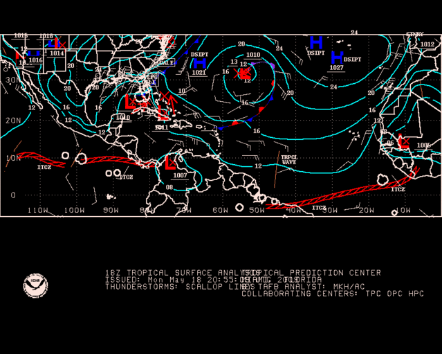
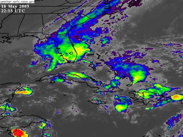
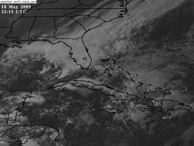
wxman57 wrote:I've been out of touch all day, speaking at a media event in Baton Rouge. Just taking a look at things, I don't see anything where NHC Has the invest up. Straight SE flow. No evidence of an LLC and pressures relatively high. I DO see turning in the SE Gulf along the cold front, however any low there is just a frontal wave at this point. Better chance of the western area developing than the eastern area, I would think. But it won't be tropical, at least for a few days. Considerable cold air advection into the eastern Gulf now.


look closer there there big cheese.. :)

do agree on the western area though ..
0 likes   

User avatar
Tampa Bay Hurricane
Category 5
Category 5
Posts: 5597
Age: 37
Joined: Fri Jul 22, 2005 7:54 pm
Location: St. Petersburg, FL

#131 Postby Tampa Bay Hurricane » Mon May 18, 2009 6:28 pm

Feels more like a cold front right now. It'll probably take until
Wednesday morning to transition if it does so (the low, extra- to
subtropical if it does that).

Gettin windy here in Da Burg Baby!!! (Saint Petersburg)
Okay not THAT windy just 20 mph gusts 30 mph but still
nice and cool.
0 likes   

User avatar
cycloneye
Admin
Admin
Posts: 143865
Age: 68
Joined: Thu Oct 10, 2002 10:54 am
Location: San Juan, Puerto Rico

Re: Invest 90L Models

#132 Postby cycloneye » Mon May 18, 2009 6:28 pm

18z GFDL

292
WHXX04 KWBC 182325
CHGQLM
ATTENTION...NATIONAL HURRICANE CENTER

NCEP COUPLED GFDL HURRICANE MODEL FORECAST MADE FOR

TROPICAL DEPRESSION INVEST 90L

INITIAL TIME 18Z MAY 18

DISCLAIMER ... THIS INFORMATION IS PROVIDED AS GUIDANCE. IT
REQUIRES INTERPRETATION BY HURRICANE SPECIALISTS AND SHOULD
NOT BE CONSIDERED AS A FINAL PRODUCT. PLEASE SEE THE TPC/NHC
OFFICIAL FORECAST.


FORECAST STORM POSITION

HOUR LATITUDE LONGITUDE HEADING/SPEED(KT)

0 21.8 76.0 360./11.1
6 22.1 76.4 311./ 5.0
12 22.8 75.9 35./ 8.2
18 23.9 75.4 25./12.1
24 24.8 74.6 40./12.0
30 25.5 74.4 14./ 6.9
36 26.6 74.6 352./10.9
42 27.6 75.5 318./12.9
48 28.4 77.4 292./18.6
54 28.5 79.2 276./16.3
60 28.8 80.9 277./14.7
66 28.7 82.7 267./15.9
72 28.5 83.8 263./ 9.8
78 28.5 84.9 271./ 9.4
84 28.6 85.8 277./ 7.9
90 29.0 86.3 307./ 5.7
96 29.5 86.6 324./ 5.8
102 30.2 87.2 322./ 8.7
108 30.8 87.8 308./ 7.7
114 31.3 88.4 313./ 7.1
120 31.9 88.8 330./ 7.4
126 32.5 89.2 329./ 6.8


0 likes   

User avatar
Cookie
S2K Supporter
S2K Supporter
Posts: 477
Age: 37
Joined: Sun Dec 14, 2008 11:13 am
Location: Isle Of lewis scotland

Re:

#133 Postby Cookie » Mon May 18, 2009 6:32 pm

Tampa Bay Hurricane wrote:Feels more like a cold front right now. It'll probably take until
Wednesday morning to transition if it does so (the low, extra- to
subtropical if it does that).

Gettin windy here in Da Burg Baby!!! (Saint Petersburg)
Okay not THAT windy just 20 mph gusts 30 mph but still
nice and cool.


try the west coast of scotland had winds of 75 mph this month,
0 likes   

User avatar
cycloneye
Admin
Admin
Posts: 143865
Age: 68
Joined: Thu Oct 10, 2002 10:54 am
Location: San Juan, Puerto Rico

Re: Invest 90L Models=First GFDL run

#134 Postby cycloneye » Mon May 18, 2009 6:36 pm

GFDL is quite bullish.

Image

Image
0 likes   

User avatar
ronjon
Category 5
Category 5
Posts: 4811
Joined: Fri Aug 19, 2005 5:17 pm
Location: Hernando Beach, FL

Re: INVEST 90L North of Cuba

#135 Postby ronjon » Mon May 18, 2009 6:38 pm

Yes the GOM low is starting to wind up - this system will be big (think nor'easter in the GOM). Anytime these low pressure systems get stacked, they really dominate the flow over a large area. The definition of whether this storm is extratropical or subtropical is really semantics - the effects will be the same. Ask KWT or Cookie about the major N Atlantic storms - some with extremely low pressures. I'm not trying to hype this storm more than it needs to be but think of a very large tropical storm - with gales extending hundreds of miles from the center. What separates this storm from others is the intense upper level energy that will be supporting low pressure at the surface - highly unusual at such a low latitude this time of year.
0 likes   

User avatar
HURAKAN
Professional-Met
Professional-Met
Posts: 46086
Age: 38
Joined: Thu May 20, 2004 4:34 pm
Location: Key West, FL
Contact:

#136 Postby HURAKAN » Mon May 18, 2009 6:39 pm

Image

Until a well-defined LLC develops, all these is for entertainment purposes.
0 likes   

User avatar
Cookie
S2K Supporter
S2K Supporter
Posts: 477
Age: 37
Joined: Sun Dec 14, 2008 11:13 am
Location: Isle Of lewis scotland

Re: INVEST 90L North of Cuba

#137 Postby Cookie » Mon May 18, 2009 6:42 pm

ronjon wrote:Yes the GOM low is starting to wind up - this system will be big (think nor'easter in the GOM). Anytime these low pressure systems get stacked, they really dominate the flow over a large area. The definition of whether this storm is extratropical or subtropical is really semantics - the effects will be the same. Ask KWT or Cookie about the major N Atlantic storms - some with extremely low pressures. I'm not trying to hype this storm more than it needs to be but think of a very large tropical storm - with gales extending hundreds of miles from the center. What separates this storm from others is the intense upper level energy that will be supporting low pressure at the surface - highly unusual at such a low latitude this time of year.


sorry to go off topic slightly but the deepest low to hit west coast scotland since I was living here with winds of 120 mph in the western isles and 140 on north rhona in January 2005, at its deepest the low was 942 mb, which is pretty low for up here.
0 likes   

User avatar
cycloneye
Admin
Admin
Posts: 143865
Age: 68
Joined: Thu Oct 10, 2002 10:54 am
Location: San Juan, Puerto Rico

Re: INVEST 90L North of Cuba

#138 Postby cycloneye » Mon May 18, 2009 6:52 pm

00
ABNT20 KNHC 182335
TWOAT
SPECIAL TROPICAL WEATHER OUTLOOK
NWS TPC/NATIONAL HURRICANE CENTER MIAMI FL
735 PM EDT MON MAY 18 2009

FOR THE NORTH ATLANTIC...CARIBBEAN SEA AND THE GULF OF MEXICO...

SATELLITE IMAGES AND SURFACE OBSERVATIONS INDICATE THAT THERE HAS
BEEN LITTLE CHANGE WITH A WEAK SURFACE LOW LOCATED JUST TO THE
SOUTH OF THE CENTRAL BAHAMAS. SOME SLOW DEVELOPMENT OF THIS SYSTEM
IS POSSIBLE DURING THE NEXT DAY OR TWO AS IT MOVES GENERALLY
NORTHWARD AT 10 TO 15 MPH. AN AIR FORCE RESERVE HURRICANE HUNTER
AIRCRAFT WILL INVESTIGATE THE SYSTEM ON TUESDAY...IF NECESSARY.
THERE IS A LOW CHANCE...LESS THAN 30 PERCENT...OF THIS SYSTEM
BECOMING A TROPICAL CYCLONE DURING THE NEXT 48 HOURS. ANOTHER
SPECIAL OUTLOOK REGARDING THIS SYSTEM WILL BE ISSUED TUESDAY
MORNING.

$$
FORECASTER BLAKE

http://www.nhc.noaa.gov/text/refresh/MI ... 2335.shtml

0 likes   

User avatar
wxman57
Moderator-Pro Met
Moderator-Pro Met
Posts: 22951
Age: 67
Joined: Sat Jun 21, 2003 8:06 pm
Location: Houston, TX (southwest)

Re: INVEST 90L North of Cuba

#139 Postby wxman57 » Mon May 18, 2009 6:55 pm

Quite a few surface obs in the area - there is no "weak surface low". I see straight SE flow from the DR to southern FL. Any circulation is aloft in the mid levels.
0 likes   

cpdaman
Category 5
Category 5
Posts: 3131
Joined: Sat Jun 10, 2006 11:44 am
Location: SPB county (gulf stream)

Re: INVEST 90L North of Cuba

#140 Postby cpdaman » Mon May 18, 2009 6:55 pm

hasn't rained too much at my house today..(extreme SE palm beach county) ..but just put the gauge out and looks like some decent storms over the water.....i think i'm good for 4 inches easy (in the next 36-48 hours)

this is a small weak surface low (apparently) .....and i don't more than 1 obs. within 50 miles of it's center
Last edited by cpdaman on Mon May 18, 2009 6:59 pm, edited 1 time in total.
0 likes   


Return to “2009”

Who is online

Users browsing this forum: No registered users and 1 guest