
Looks like shear has eased off just a little bit again as convection seems to be flaring up closer to the center. I don't think this is totally cold cored anymore given the apperence BUT its impossible to know without recon really, I'd punt though that this may well be a subtropical system, whether or not its enough to call it a STC I don't know yet.
Also remember with a cold cored ULL nearby, the upper air temps will be lower with it which means whilst SST's are lowering the lapse rates may still be high enough for shallow convection to keep building even as it gets closer to the shelf waters.
GOM: INVEST 90L
Moderator: S2k Moderators


-
Category 5

- Category 5

- Posts: 10074
- Age: 36
- Joined: Sun Feb 11, 2007 10:00 pm
- Location: New Brunswick, NJ
- Contact:
-
Bailey1777
- S2K Supporter

- Posts: 962
- Joined: Mon Jul 31, 2006 6:23 pm
- Location: Houston, Texas

-
DanKellFla

- Category 5
- Posts: 1291
- Joined: Fri Mar 17, 2006 12:02 pm
- Location: Lake Worth, Florida

-
Rainband
Re: GOM: INVEST 90L - STWO: Less than 30%
In parts of the "sunshine state"...using that term loosely, it's wettest May on record, either way this thing made history wether it's named or not.
0 likes
-
TropicalWXMA

- Tropical Storm

- Posts: 114
- Joined: Wed May 18, 2005 9:22 pm
- Location: Boston, MA
- Contact:
Re: GOM: INVEST 90L - STWO: Less than 30%
Main circulation is now underneath a pretty good blow up of convection!

Clearly visible on this loop:
http://www.nrlmry.navy.mil/nexsat-bin/n ... LAY=Single
Clearly visible on this loop:
http://www.nrlmry.navy.mil/nexsat-bin/n ... LAY=Single
0 likes
Re: GOM: INVEST 90L - STWO: Less than 30%
Still looks like a NNE drift, appears to be sneaking under the convection on that side.

Edit: Hey WXMA, hit the reply button with the same observation
Edit: Hey WXMA, hit the reply button with the same observation
Last edited by xironman on Fri May 22, 2009 6:13 pm, edited 1 time in total.
0 likes
-
cycloneye

- Admin

- Posts: 149508
- Age: 69
- Joined: Thu Oct 10, 2002 10:54 am
- Location: San Juan, Puerto Rico
Re: GOM: INVEST 90L - STWO: Less than 30%
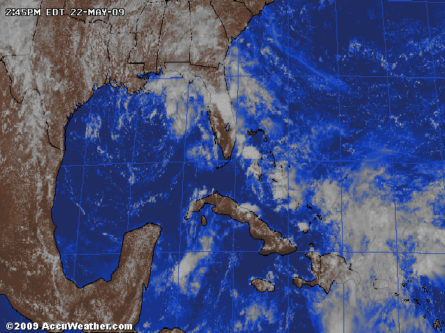
This shot is losing daylight but still you can see the convection now over the circulation.

0 likes
-
TropicalWXMA
- Tropical Storm
- Posts: 114
- Joined: Wed May 18, 2005 9:22 pm
- Location: Boston, MA
- Contact:
Re: GOM: INVEST 90L - STWO: Less than 30%
Hm, it appears that my post came first so, maybe you should've done that. Just saying.
Hopefully 90L can grow a LITTLE bit before having to deal with the land and losing some of it's Gulf water energy!!
Hopefully 90L can grow a LITTLE bit before having to deal with the land and losing some of it's Gulf water energy!!
xironman wrote:Still looks like a NNE drift, appears to be sneaking under the convection on that side.
Edit: Hey WXMA, hit the reply button with the same observation
0 likes
-
tolakram
- Admin
- Posts: 20186
- Age: 62
- Joined: Sun Aug 27, 2006 8:23 pm
- Location: Florence, KY (name is Mark)
Re: GOM: INVEST 90L - STWO: Less than 30%
Looking more and more tropical.

Can't resist the MODIS closeup from earlier today.

Buoy data:
http://www.ndbc.noaa.gov/station_page.php?station=42039
Temps rising as pressure falls.
Can't resist the MODIS closeup from earlier today.
Buoy data:
http://www.ndbc.noaa.gov/station_page.php?station=42039
Temps rising as pressure falls.
Last edited by tolakram on Fri May 22, 2009 6:41 pm, edited 1 time in total.
0 likes
-
Dionne

- S2K Supporter
- Posts: 1616
- Age: 74
- Joined: Mon Jan 02, 2006 8:51 am
- Location: SW Mississippi....Alaska transplant via a Southern Belle.
Re: GOM: INVEST 90L - STWO: Less than 30%
Winds out of the east since last night. Several squall lines.....winds to around 30 mph.....reports vary. Rain on and off all day. A soaking rain. No severe weather. No local flooding. 100% in the forecast for substantial rain in the near future.
It is a bit strange seeing the clouds rolling in out of the east this early in the season. They look exactly like the clouds that say something is happening in the GOM.
It is a bit strange seeing the clouds rolling in out of the east this early in the season. They look exactly like the clouds that say something is happening in the GOM.
0 likes
-
cycloneye
- Admin
- Posts: 149508
- Age: 69
- Joined: Thu Oct 10, 2002 10:54 am
- Location: San Juan, Puerto Rico
Re: GOM: INVEST 90L - STWO: Less than 30%
NHC Increases probability of TD forming
005
ABNT20 KNHC 222345
TWOAT
SPECIAL TROPICAL WEATHER OUTLOOK
NWS TPC/NATIONAL HURRICANE CENTER MIAMI FL
745 PM EDT FRI MAY 22 2009
FOR THE NORTH ATLANTIC...CARIBBEAN SEA AND THE GULF OF MEXICO...
A BROAD AREA OF LOW PRESSURE IS CENTERED OVER THE GULF OF MEXICO
ABOUT 200 MILES SOUTH OF PENSACOLA FLORIDA. SATELLITE IMAGERY
INDICATES THAT THE ASSOCIATED SHOWERS AND THUNDERSTORMS CONTINUE TO
INCREASE THIS EVENING. ADDITIONAL DEVELOPMENT OF THIS SYSTEM IS
POSSIBLE...AND A TROPICAL DEPRESSION COULD FORM BEFORE THE LOW
MOVES INLAND OVER THE NORTHERN GULF COAST ON SATURDAY. AN AIR
FORCE RESERVE HURRICANE HUNTER AIRCRAFT WILL INVESTIGATE THE LOW
TOMORROW...IF NECESSARY. THERE IS A MEDIUM CHANCE...30 TO 50
PERCENT...OF THIS SYSTEM BECOMING A TROPICAL CYCLONE DURING THE
NEXT 48 HOURS. REGARDLESS OF DEVELOPMENT...HEAVY RAINS AND
OCCASIONALLY GUSTY WINDS ARE EXPECTED ALONG PORTIONS OF THE
NORTHERN GULF COAST TONIGHT AND SATURDAY...AND INTERESTS IN THIS
AREA SHOULD MONITOR THE PROGRESS OF THE SYSTEM.
ANOTHER SPECIAL OUTLOOK ON THIS SYSTEM WILL BE ISSUED EARLY SATURDAY
MORNING...IF NECESSARY.
$$
FORECASTER BEVEN
0 likes
-
tolakram
- Admin
- Posts: 20186
- Age: 62
- Joined: Sun Aug 27, 2006 8:23 pm
- Location: Florence, KY (name is Mark)
Re: GOM: INVEST 90L - STWO: Between 30-50% / TD Could form
First orange juice of the year.
Looks like we're going to get heavy rains out of this mid week.
Looks like we're going to get heavy rains out of this mid week.
0 likes
-
cycloneye
- Admin
- Posts: 149508
- Age: 69
- Joined: Thu Oct 10, 2002 10:54 am
- Location: San Juan, Puerto Rico
Re: GOM: INVEST 90L - STWO: Between 30-50% / TD could form
By what NHC says in that recent outlook,it may be fully tropical instead of Sub?
0 likes
-
Dean4Storms
- S2K Supporter
- Posts: 6358
- Age: 63
- Joined: Sun Aug 31, 2003 1:01 pm
- Location: Miramar Bch. FL
Mobile NWS AFD says that the low is warming, albeit slowly.......
INTERESTINGLY ENOUGH...INSITU TEMPERATURES SHOWN IN UPPER
AIR CHARTS ANALYZED OVER THE LAST FEW DAYS INDICATES AN OVERALL
WARMING OF THE MEAN TEMPERATURE NEAR THE CENTER OF THE LOW OF ABOUT
3 DEGREES CELSIUS. WE OBSERVED THIS AS FOLLOWS:
850 MB 700 MB 500 MB:
TUESDAY EVENING 13 C 4 C -11 C
WEDNESDAY MORNING 14 C 6 C -11 C
THURSDAY EVENING 15 C 7 C -9 C
THIS MORNING (FRI) 16 C 7 C -8 C
IT SHOULD BE NOTED THAT 3 DEGREES IN 60 HOURS OR SO DOES NOT INDICATE
NECESSARILY THAT THIS LOW IS IN ANY HURRY TO TRANSITION.
0 likes

-
tolakram
- Admin
- Posts: 20186
- Age: 62
- Joined: Sun Aug 27, 2006 8:23 pm
- Location: Florence, KY (name is Mark)
Re: GOM: INVEST 90L - 7:45 PM EDT STWO: Between 30-50%
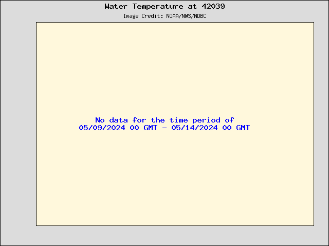
Water temps near the center have dropped a lot since a couple of days ago.
Air temps continue to rise.
Air temps continue to rise.
0 likes
Who is online
Users browsing this forum: No registered users and 40 guests