WHXX01 KWBC 230038
CHGHUR
TROPICAL CYCLONE GUIDANCE MESSAGE
NWS TPC/NATIONAL HURRICANE CENTER MIAMI FL
0038 UTC SAT MAY 23 2009
DISCLAIMER...NUMERICAL MODELS ARE SUBJECT TO LARGE ERRORS.
PLEASE REFER TO NHC OFFICIAL FORECASTS FOR TROPICAL CYCLONE
AND SUBTROPICAL CYCLONE INFORMATION.
ATLANTIC OBJECTIVE AIDS FOR
DISTURBANCE INVEST (AL902009) 20090523 0000 UTC
...00 HRS... ...12 HRS... ...24 HRS. .. ...36 HRS...
090523 0000 090523 1200 090524 0000 090524 1200
LAT LON LAT LON LAT LON LAT LON
BAMS 27.7N 87.8W 29.1N 88.5W 30.6N 89.0W 32.1N 89.5W
BAMD 27.7N 87.8W 29.2N 88.2W 31.1N 89.1W 32.8N 90.2W
BAMM 27.7N 87.8W 29.0N 88.4W 30.6N 89.0W 32.1N 89.7W
LBAR 27.7N 87.8W 29.1N 88.1W 30.7N 88.2W 32.4N 88.5W
SHIP 25KTS 30KTS 36KTS 41KTS
DSHP 25KTS 30KTS 31KTS 28KTS
...48 HRS... ...72 HRS... ...96 HRS. .. ..120 HRS...
090525 0000 090526 0000 090527 0000 090528 0000
LAT LON LAT LON LAT LON LAT LON
BAMS 33.4N 89.9W 35.7N 91.2W 38.1N 91.5W 40.2N 89.7W
BAMD 34.1N 91.5W 36.6N 93.7W 39.8N 94.6W 42.6N 92.7W
BAMM 33.4N 90.6W 35.5N 92.4W 38.0N 93.0W 40.4N 90.5W
LBAR 34.1N 88.4W 37.1N 86.6W 38.9N 81.8W 40.1N 73.6W
SHIP 47KTS 54KTS 57KTS 60KTS
DSHP 27KTS 27KTS 28KTS 29KTS
...INITIAL CONDITIONS...
LATCUR = 27.7N LONCUR = 87.8W DIRCUR = 345DEG SPDCUR = 6KT
LATM12 = 26.6N LONM12 = 87.5W DIRM12 = 347DEG SPDM12 = 4KT
LATM24 = 25.8N LONM24 = 86.7W
WNDCUR = 25KT RMAXWD = 100NM WNDM12 = 25KT
CENPRS = 1006MB OUTPRS = 1010MB OUTRAD = 250NM SDEPTH = M
RD34NE = 0NM RD34SE = 0NM RD34SW = 0NM RD34NW = 0NM
GOM: INVEST 90L
Moderator: S2k Moderators
-
cycloneye

- Admin

- Posts: 149514
- Age: 69
- Joined: Thu Oct 10, 2002 10:54 am
- Location: San Juan, Puerto Rico
Re: GOM: Invest 90L Models
0 likes
-
Plant grower
- Tropical Depression

- Posts: 73
- Joined: Sat Feb 07, 2009 4:20 pm
Re: GOM: INVEST 90L - 7:45 PM EDT STWO: Between 30-50%
Looks like a TD smells like a TD yes it's a TD to me. Welcome to hurricane season 09 everyone 
0 likes


Re: GOM: INVEST 90L - 7:45 PM EDT STWO: Between 30-50%
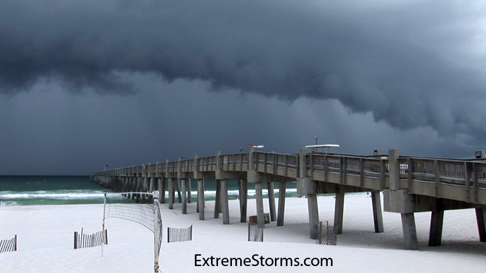
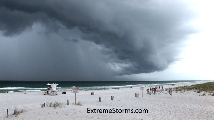
Here's a couple of video stills as the heavy squall line from that Low hit the beach here in Pensacola. Taken around 2:20 CDT.
http://www.extremestorms.com/storm3.jpg
http://www.extremestorms.com/storm1.jpg
http://www.extremestorms.com/storm3.jpg
http://www.extremestorms.com/storm1.jpg
0 likes


Re: GOM: INVEST 90L - 7:45 PM EDT STWO: Between 30-50%
Convection really firing up in the north-central gulf - looks like the transition to tropical may occur tonight. Hard to tell where the center is now - may be just to the SW of the eastern convective blob.

0 likes
-
Dean4Storms
- S2K Supporter

- Posts: 6358
- Age: 63
- Joined: Sun Aug 31, 2003 1:01 pm
- Location: Miramar Bch. FL
Some rotating heavy Convection SSW of P'Cola on long range radar......
http://radar.weather.gov/ridge/radar.ph ... 1&loop=yes
http://radar.weather.gov/ridge/radar.ph ... 1&loop=yes
0 likes
-
Bailey1777
- S2K Supporter
- Posts: 962
- Joined: Mon Jul 31, 2006 6:23 pm
- Location: Houston, Texas
Re: GOM: INVEST 90L - 7:45 PM EDT STWO: Between 30-50%
System has already been a killer....not a good start to the season for those who are most vulnerable...
The large extratropical storm that has been pounding Florida and the Bahamas this week with heavy rain and high surf extended its reach yesterday, killing at least 11 people in Haiti. According to Reuters, most of the victims were killed while crossing rivers or when their flimsy homes collapsed. Approximately six inches of rain fell on Haiti's southwest peninsula in the 24 hours ending at 8pm EDT. Hundreds of homes were flooded and dozens destroyed in the flooding, which left 40% of the southern city of Cayes underwater. The impoverished Caribbean country is still struggling to recover from the massive flooding that killed over 800 people during the hurricane season of 2008. In March, UN chief Ban Ki-moon and Bill Clinton--who was this week appointed UN special envoy to the island--toured Haiti together and urged the international community to continue to aid the country. Participants at a Washington international donors conference in April agreed to donate $324 million to help Haiti rebuild.
http://www.wunderground.com/blog/JeffMa ... rynum=1227
0 likes
-
Dean4Storms
- S2K Supporter
- Posts: 6358
- Age: 63
- Joined: Sun Aug 31, 2003 1:01 pm
- Location: Miramar Bch. FL
Has all the looks tonight of trying to go tropical, the question now becomes can it sustain the convection overnight and will it run out of room before landfall. At most I can't see it getting much above minimum TS strength, more rain than anything with maybe the possibility of a few Waterspouts moving ashore tomorrow.
0 likes
-
tolakram
- Admin
- Posts: 20186
- Age: 62
- Joined: Sun Aug 27, 2006 8:23 pm
- Location: Florence, KY (name is Mark)
Re: GOM: INVEST 90L - 7:45 PM EDT STWO: Between 30-50%
Water close to shore (Gulf Shores) is still fairly warm.
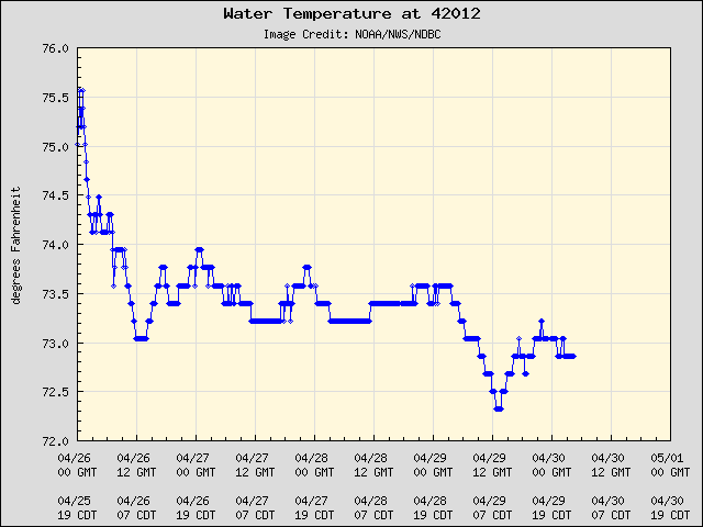
Very shallow, of course.
Very shallow, of course.
0 likes
Re: GOM: INVEST 90L - 7:45 PM EDT STWO: Between 30-50%
Persistent onshore flow could lead to some minor flooding in coastal LA and MS
COASTAL HAZARD MESSAGE
NATIONAL WEATHER SERVICE NEW ORLEANS LA
133 PM CDT FRI MAY 22 2009
ORLEANS-UPPER ST. BERNARD-LOWER PLAQUEMINES-LOWER ST. BERNARD-
HANCOCK-
...COASTAL FLOOD WARNING REMAINS IN EFFECT UNTIL 7 PM CDT
SATURDAY....
MINOR FLOODING OF LOW LYING ROADWAYS MAY OCCUR IN HANCOCK COUNTY
MISSISSIPPI...AND MINOR FLOODING OF LOW LYING AREAS MAY OCCUR
OUTSIDE OF HURRICANE PROTECTION LEVEES FROM NEAR LAKE CATHERINE
AND LAKE BORGNE...TO SOUTHWEST PASS OF THE MISSISSIPPI RIVER.
TIDES ARE EXPECTED TO RISE TO 2 TO 3 FEET ABOVE NORMAL TONIGHT AND
SATURDAY.
A COASTAL FLOOD WARNING MEANS THAT FLOODING IS OCCURRING OR
IMMINENT. COASTAL RESIDENTS IN THE WARNED AREA SHOULD BE ALERT
FOR RISING WATER...AND TAKE APPROPRIATE ACTION TO PROTECT LIFE
AND PROPERTY.
0 likes
-
CrazyC83
- Professional-Met

- Posts: 34315
- Joined: Tue Mar 07, 2006 11:57 pm
- Location: Deep South, for the first time!
Re: GOM: INVEST 90L - 7:45 PM EDT STWO: Between 30-50%
jinftl wrote:System has already been a killer....not a good start to the season for those who are most vulnerable...
The large extratropical storm that has been pounding Florida and the Bahamas this week with heavy rain and high surf extended its reach yesterday, killing at least 11 people in Haiti. According to Reuters, most of the victims were killed while crossing rivers or when their flimsy homes collapsed. Approximately six inches of rain fell on Haiti's southwest peninsula in the 24 hours ending at 8pm EDT. Hundreds of homes were flooded and dozens destroyed in the flooding, which left 40% of the southern city of Cayes underwater. The impoverished Caribbean country is still struggling to recover from the massive flooding that killed over 800 people during the hurricane season of 2008. In March, UN chief Ban Ki-moon and Bill Clinton--who was this week appointed UN special envoy to the island--toured Haiti together and urged the international community to continue to aid the country. Participants at a Washington international donors conference in April agreed to donate $324 million to help Haiti rebuild.
http://www.wunderground.com/blog/JeffMa ... rynum=1227
And the season hasn't (officially) even started yet!
0 likes
-
Frank P
- S2K Supporter
- Posts: 2779
- Joined: Fri Aug 29, 2003 10:52 am
- Location: Biloxi Beach, Ms
- Contact:
Re: GOM: INVEST 90L - 7:45 PM EDT STWO: Between 30-50%
Hard to tell exactly where the center is on radar, SSW of Pensacola seems reasonable, but the overall radar presentation of the storm cells indicate its not moving very fast. We had a decent cell move thru Biloxi around 6:00 pm tonight, otherwise pretty quiet on the beach. Good thing its' not August... would not be surprised for this to make TD tomorrow if it could slow down just a tad prior to going inland...
0 likes
-
SunnyThoughts
- Category 5

- Posts: 2263
- Joined: Wed Jul 09, 2003 12:42 pm
- Location: Pensacola, Florida
Re: GOM: INVEST 90L - 7:45 PM EDT STWO: Between 30-50%
Im driving from Pensacola to Biloxi tomorrow, sure not looking forward to THAT drive now.. Everybody along the coast stay dry and safe.
0 likes
-
Bailey1777
- S2K Supporter
- Posts: 962
- Joined: Mon Jul 31, 2006 6:23 pm
- Location: Houston, Texas

-
MGC

- S2K Supporter
- Posts: 5940
- Joined: Sun Mar 23, 2003 9:05 pm
- Location: Pass Christian MS, or what is left.
Re: GOM: INVEST 90L - 7:45 PM EDT STWO: Between 30-50%
If convection continues to increase near the center tonight than it is quite possible that this system gets classified tomorrow by the NHC. This low has really become better organized since this morning. I don't want to wake up to TS warning.....MGC
0 likes
-
HURAKAN

- Professional-Met
- Posts: 46084
- Age: 39
- Joined: Thu May 20, 2004 4:34 pm
- Location: Key West, FL
- Contact:
Re: GOM: INVEST 90L - 7:45 PM EDT STWO: Between 30-50%
MGC wrote:If convection continues to increase near the center tonight than it is quite possible that this system gets classified tomorrow by the NHC. This low has really become better organized since this morning. I don't want to wake up to TS warning.....MGC
Fortunately the effects are not going to be much different.
0 likes
Who is online
Users browsing this forum: No registered users and 31 guests