ATL : INVEST 93L

Moderator: S2k Moderators

Message
Author
User avatar
senorpepr
Military Met/Moderator
Posts: 12542
Age: 42
Joined: Fri Aug 22, 2003 9:22 pm
Location: Mackenbach, Germany
Contact:

Re: Re:

#341 Postby senorpepr » Sat Jun 27, 2009 6:48 pm

Aric Dunn wrote:
senorpepr wrote:Blah... "code yellow" is so... greatone-ish.

lol ...
well it is a different forecaster this time ..


Well, it would be one thing if those forecasters said "code yellow"...
0 likes   

User avatar
AdamFirst
S2K Supporter
S2K Supporter
Posts: 2491
Age: 36
Joined: Thu Aug 14, 2008 10:54 am
Location: Port Saint Lucie, FL

Re: ATL : INVEST 93L

#342 Postby AdamFirst » Sat Jun 27, 2009 6:54 pm

We won't have much to deal with this system until tomorrow evening into Monday morning when it goes farther into the Gulf...so now we just gotta sit back and see if it survives until then.
0 likes   

User avatar
cycloneye
Admin
Admin
Posts: 143867
Age: 68
Joined: Thu Oct 10, 2002 10:54 am
Location: San Juan, Puerto Rico

Re: ATL : INVEST 93L

#343 Postby cycloneye » Sat Jun 27, 2009 6:56 pm

Here is the code yellow.

Not surprised by the downgrade of code as its overland in Yucatan and still doesnt have a well defined Low Level Circulation.

Image
0 likes   

User avatar
lrak
S2K Supporter
S2K Supporter
Posts: 1770
Age: 58
Joined: Thu Jun 21, 2007 2:48 pm
Location: Corpus Christi, TX

Re: ATL : INVEST 93L

#344 Postby lrak » Sat Jun 27, 2009 7:07 pm

http://cimss.ssec.wisc.edu/tropic2/real ... oom=&time=

Since this will not develope over land and imerge off the west coast of the Yucatan will it continue the sharp turn to the right towards Florida like all the models have indicated or continue towards Mexico now?
0 likes   

User avatar
ronjon
Category 5
Category 5
Posts: 4811
Joined: Fri Aug 19, 2005 5:17 pm
Location: Hernando Beach, FL

Re: ATL : INVEST 93L

#345 Postby ronjon » Sat Jun 27, 2009 7:09 pm

TAFB 48 hr forecast.

Image
0 likes   

User avatar
HouTXmetro
Category 5
Category 5
Posts: 3949
Joined: Sun Jun 13, 2004 6:00 pm
Location: District of Columbia, USA

Re: ATL : INVEST 93L

#346 Postby HouTXmetro » Sat Jun 27, 2009 7:18 pm

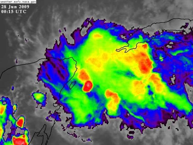
lrak wrote:http://cimss.ssec.wisc.edu/tropic2/real-time/dlmmain.php?&basin=atlantic&sat=wg8&prod=dlm1&zoom=&time=

Since this will not develope over land and imerge off the west coast of the Yucatan will it continue the sharp turn to the right towards Florida like all the models have indicated or continue towards Mexico now?


With that High Anchored in the middle of the Gulf it has no choice but go North/Northeast.
0 likes   

User avatar
cycloneye
Admin
Admin
Posts: 143867
Age: 68
Joined: Thu Oct 10, 2002 10:54 am
Location: San Juan, Puerto Rico

Re: ATL : INVEST 93L

#347 Postby cycloneye » Sat Jun 27, 2009 7:20 pm

TROPICAL WEATHER DISCUSSION
NWS TPC/NATIONAL HURRICANE CENTER MIAMI FL
805 PM EDT SAT JUN 27 2009

TROPICAL WEATHER DISCUSSION FOR NORTH AMERICA...CENTRAL
AMERICA...GULF OF MEXICO...CARIBBEAN SEA...NORTHERN SECTIONS
OF SOUTH AMERICA...AND ATLANTIC OCEAN TO THE AFRICAN COAST
FROM THE EQUATOR TO 32N. THE FOLLOWING INFORMATION IS BASED
ON SATELLITE IMAGERY...METEOROLOGICAL ANALYSIS...WEATHER
OBSERVATIONS...AND RADAR.

BASED ON 1800 UTC SURFACE ANALYSIS AND SATELLITE IMAGERY THROUGH
2245 UTC.

...TROPICAL WAVES...

A VIGOROUS TROPICAL WAVE EXTENDS FROM 22N87W SOUTHWARD ACROSS
CENTRAL AMERICA TO 7N89W IN THE NORTHEAST PACIFIC. SCATTERED
MODERATE ISOLATED STRONG CONVECTION IS OCCURRING WITHIN 300 NM
EAST OF THE WAVE AXIS NORTH OF 18N. ISOLATE MODERATE TO STRONG
CONVECTION IS ALSO OCCURRING OVER ALL OF THE CENTRAL AMERICAN
COUNTRIES IN PART FROM FORCING BY THE WAVE IN PART FROM NORMAL
AFTERNOON HEATING IN THE TROPICS. NUMEROUS STATION...BUOY...
AND A 1506Z ASCAT PASS SHOW A DISTINCT TROUGH AT THE
SURFACE...BUT AS OF YET NO SURFACE LOW. THE GFS 700 MB ANALYSES
SUGGEST THAT THE TROUGH HAS A CLOSED CIRCULATION AT THIS LEVEL.
THE WAVE IS ALSO WELL-DEFINED IN THE TOTAL PRECIPITABLE WATER
IMAGERY WITH A MAXIMUM EAST OF THE WAVE AXIS. THE WAVE HAS BEEN
MOVING WESTWARD AT ABOUT 12 KT.

http://www.storm2k.org/weather/hw3.php? ... hwvmetric=
0 likes   

User avatar
wxman57
Moderator-Pro Met
Moderator-Pro Met
Posts: 22951
Age: 67
Joined: Sat Jun 21, 2003 8:06 pm
Location: Houston, TX (southwest)

Re: ATL : INVEST 93L

#348 Postby wxman57 » Sat Jun 27, 2009 7:25 pm

lrak wrote:But wait a minute this storm isn't tall or formed up, are the models anticipating a tall storm really fast? Otherwise the low level winds are tracking West to Mexico?


No, the models are tracking the low to mid-level vorticity. There's nothing to take it to the west. And nothing to give you any rain there in Corpus, Irak. Sorry.

Once again, convection flares up then falls apart. Tops are warming significantly now. Surface obs show nothing in the area, not even a well-defined trof, much less a low center. What I do see is improved outflow across the disturbance. But a trof is digging south through Florida, so the more favorable upper-level winds may not last long. And still there's nothing to focus the convection. Be thankful, those of you in Florida, that you may get some well-needed rain without the power getting knocked out for weeks in this heat.
0 likes   

User avatar
HURAKAN
Professional-Met
Professional-Met
Posts: 46086
Age: 38
Joined: Thu May 20, 2004 4:34 pm
Location: Key West, FL
Contact:

#349 Postby HURAKAN » Sat Jun 27, 2009 7:33 pm

Image
0 likes   

User avatar
senorpepr
Military Met/Moderator
Posts: 12542
Age: 42
Joined: Fri Aug 22, 2003 9:22 pm
Location: Mackenbach, Germany
Contact:

#350 Postby senorpepr » Sat Jun 27, 2009 7:36 pm

AL, 93, 2009062800, , BEST, 0, 200N, 874W, 25, 1008, DB, 34, NEQ, 0, 0, 0, 0, 1010, 90, 60, 0, 0, L, 0, , 0, 0, INVEST, M,
0 likes   

User avatar
MGC
S2K Supporter
S2K Supporter
Posts: 5885
Joined: Sun Mar 23, 2003 9:05 pm
Location: Pass Christian MS, or what is left.

Re: ATL : INVEST 93L

#351 Postby MGC » Sat Jun 27, 2009 7:36 pm

This disturbance should be a code "pink" as in "it ain't gonna happen." Just a cluster of unorganized thunderstorms drifting to the north. Might get its act together in the GOM on Monday or Tuesday.....MGC
0 likes   

User avatar
brunota2003
S2K Supporter
S2K Supporter
Posts: 9476
Age: 34
Joined: Sat Jul 30, 2005 9:56 pm
Location: Stanton, KY...formerly Havelock, NC
Contact:

#352 Postby brunota2003 » Sat Jun 27, 2009 7:44 pm

Just a tropical wave being aided by outflow boundaries from storms and the ULL to it's west, providing forcing to lift up the parcels of air

IMHO, of course. Is any of that right? I dunno.
0 likes   

User avatar
cycloneye
Admin
Admin
Posts: 143867
Age: 68
Joined: Thu Oct 10, 2002 10:54 am
Location: San Juan, Puerto Rico

Re: ATL : INVEST 93L

#353 Postby cycloneye » Sat Jun 27, 2009 7:52 pm

00 UTC Best Track Position


Position=Latitud,20.0n - Longitud,87.4w
Winds=25 kts
Pressure=1008 mbs
System=Disturbance

AL, 93, 2009062800, , BEST, 0, 200N, 874W, 25, 1008, DB

ftp://ftp.tpc.ncep.noaa.gov/atcf/tcweb/ ... 009.invest
0 likes   

Derek Ortt

#354 Postby Derek Ortt » Sat Jun 27, 2009 8:02 pm

I wonder if they cancelled the aircraft since none of the TWOs mentioned the possibility of a flight tomorrow
0 likes   

User avatar
Macrocane
Category 5
Category 5
Posts: 4218
Age: 36
Joined: Sun May 24, 2009 5:35 pm
Location: El Salvador

Re: ATL : INVEST 93L

#355 Postby Macrocane » Sat Jun 27, 2009 8:13 pm

As convection didn't persist, the Low level center it's not well defined, time to organize is ending and models doesn't show anything I'm not expecting important development from this Invest I would be very surprised if it becomes a TD.
0 likes   

User avatar
cycloneye
Admin
Admin
Posts: 143867
Age: 68
Joined: Thu Oct 10, 2002 10:54 am
Location: San Juan, Puerto Rico

Re: ATL : INVEST 93L

#356 Postby cycloneye » Sat Jun 27, 2009 8:17 pm

Maybe its time to look towards the east? :)
0 likes   

Derek Ortt

Re: ATL : INVEST 93L

#357 Postby Derek Ortt » Sat Jun 27, 2009 8:18 pm

cycloneye wrote:Maybe its time to look towards the east? :)


yeah... in about 6 weeks, lol
0 likes   

xironman
S2K Supporter
S2K Supporter
Posts: 2521
Joined: Sun Jun 10, 2007 4:53 pm
Location: NoVA

Re: ATL : INVEST 93L

#358 Postby xironman » Sat Jun 27, 2009 8:19 pm

As convection didn't persist, the Low level center it's not well defined, time to organize is ending and models doesn't show anything I'm not expecting important development from this Invest I would be very surprised if it becomes a TD.

Why would the time to organize be ending? The upper air pattern looks better once it is in the gulf.
0 likes   

User avatar
MGC
S2K Supporter
S2K Supporter
Posts: 5885
Joined: Sun Mar 23, 2003 9:05 pm
Location: Pass Christian MS, or what is left.

Re: ATL : INVEST 93L

#359 Postby MGC » Sat Jun 27, 2009 8:25 pm

I would not give up on 93L until it moves inland. With the tropics one never knows what Mother Nature will decide to do.....how many here gave up on the disturbance that eventually became TD-1? As I recall it looked rather pathetic in the days before it got its act together. There is the possibility that 93L could develope over the gulf......MGC
0 likes   

User avatar
Dionne
S2K Supporter
S2K Supporter
Posts: 1616
Age: 73
Joined: Mon Jan 02, 2006 8:51 am
Location: SW Mississippi....Alaska transplant via a Southern Belle.

Re: ATL : MODELS : INVEST 93L

#360 Postby Dionne » Sat Jun 27, 2009 8:37 pm

caneman wrote:
Dionne wrote:Irregardless of color code or models......today seems like the right time to stash fuel supplies for the season.


When you say fuel are you refering to Gasoline or Liquor?? :wink:


Gasoline. Two reasons; 1) warm beer sucks and 2) beer and chain saws are a bad mix. :double:
0 likes   


Return to “2009”

Who is online

Users browsing this forum: No registered users and 29 guests