New form of El Nino may increase Atlantic storms
Moderator: S2k Moderators
Forum rules
The posts in this forum are NOT official forecasts and should not be used as such. They are just the opinion of the poster and may or may not be backed by sound meteorological data. They are NOT endorsed by any professional institution or STORM2K. For official information, please refer to products from the National Hurricane Center and National Weather Service.
New form of El Nino may increase Atlantic storms
Interesting article.....2004 was an El Nino Modoki - 2009 could still get interesting
http://www.washingtonpost.com/wp-dyn/co ... 347_2.html
http://www.washingtonpost.com/wp-dyn/co ... 347_2.html
0 likes
Re: New form of El Nino may increase Atlantic storms
Interesting, but if that's the case the only Modoki El Niño that comes to my mind is 2004, does anyone know other cases?
0 likes
- Pearl River
- S2K Supporter

- Posts: 825
- Age: 67
- Joined: Fri Dec 09, 2005 6:07 pm
- Location: SELa
Re: New form of El Nino may increase Atlantic storms
This sounds like an attempt to use the "global warming" factor, even though it wasn't mentioned in the article.
0 likes
- cycloneye
- Admin

- Posts: 149777
- Age: 69
- Joined: Thu Oct 10, 2002 10:54 am
- Location: San Juan, Puerto Rico
Re: New form of El Nino may increase Atlantic storms
Macrocane wrote:Interesting, but if that's the case the only Modoki El Niño that comes to my mind is 2004, does anyone know other cases?
Maybe.well back in centuries,these kind of Modoki El Nino may haved occured sometimes.This is a very different wisdom about the effects of El Nino in the Atlantic that we have to watch.
0 likes
-
HurricaneBill
- Category 5

- Posts: 3419
- Joined: Sun Apr 11, 2004 5:51 pm
- Location: East Longmeadow, MA, USA
Re: New form of El Nino may increase Atlantic storms
Macrocane wrote:Interesting, but if that's the case the only Modoki El Niño that comes to my mind is 2004, does anyone know other cases?
1969?
0 likes
-
Ed Mahmoud
Re: New form of El Nino may increase Atlantic storms
Google Fu
http://www.agu.org/pubs/crossref/2007/2006JC003798.shtml

I don't see cold flanking the warm...
My amateur opinion, a 1997 type, and since we missed the 4 June/early July storms, an extremely calm year.
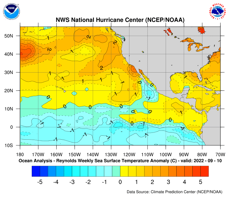
This unique warming in the central equatorial Pacific associated with a horseshoe pattern is flanked by a colder sea surface temperature anomaly (SSTA) on both sides along the equator.
http://www.agu.org/pubs/crossref/2007/2006JC003798.shtml

I don't see cold flanking the warm...
My amateur opinion, a 1997 type, and since we missed the 4 June/early July storms, an extremely calm year.
0 likes
Re: New form of El Nino may increase Atlantic storms
HurricaneBill wrote: 1969?
You're right 1969 could have been a Modoki, it was very active.
0 likes
- vacanechaser
- Category 5

- Posts: 1461
- Joined: Wed Dec 03, 2003 9:34 pm
- Location: Portsmouth, Va
- Contact:
Re: New form of El Nino may increase Atlantic storms
Ed Mahmoud wrote:Google FuThis unique warming in the central equatorial Pacific associated with a horseshoe pattern is flanked by a colder sea surface temperature anomaly (SSTA) on both sides along the equator.
http://www.agu.org/pubs/crossref/2007/2006JC003798.shtml
I don't see cold flanking the warm...
My amateur opinion, a 1997 type, and since we missed the 4 June/early July storms, an extremely calm year.
1997??? no way... i dont see that type of el nino coming... and are you saying that because those storms have not developed already this year you expect it to be very quiet for most of the season??? lets not forget 2004!!! we didnt see anything until late july early august with alex... its still way to early to know for sure, but the nino does not look to be developing that strongly..
Jesse V. Bass III
http://www.vastormphoto.com
Hurricane Intercept Research Team
0 likes
- hurricanetrack
- HurricaneTrack.com

- Posts: 1781
- Joined: Tue Dec 02, 2003 10:46 pm
- Location: Wilmington, NC
- Contact:
I would think that the lack of non-tropical development is a sign that we are not experiencing full blown El Nino effects in the Atlantic Basin. It is very typical to see little to no activity in June or July. Since there is perhaps no way to really know that YES, El Nino is keeping the Atlantic suppressed right now, we can only go by the evidence at hand- and that is simple: so far, the season is behaving exactly as climatology would suggest it should. If it is late August and we still have no named storms, then I would point a big finger at El Nino.
0 likes
Re:
good point...and i agree...the lack of storms on july 3 is not a definite nod to the power of the developing el nino (i say developing because there has to be a 3-month average ONI index of 0.5C or greater to be an offiial el nino...we have crossed into that range for about the past month...so the 3-month average doesn't meet the requirement).
Another thing to consider is that an el nino is not like a light switch that will turn on or off tropical activity. It is one factor that influences the atmospheric conditions that promote or inhibit storm formation. Generally, shear is higher in the basin during el ninos...but this is something that is always in a state of flux based on the placement of highs, lows, etc. Nor is shear a constant level across the basin....so if a system is in the right location in the Caribbean, Gulf, etc...the presence of water 1 deg Celsius warmer than normal off Peru in Ecaudor is not an automatic development deal-breaker. Just another factor to consider along with ocean temp, dry air, non-el nino shear, etc. This is a spectrum issue with degrees of impact that constantly are in flux...not a yes/no issue.
Current shear map illustrates the variability in shear across the basin....there is no reason the map won't reflect such variability during the peak of the season. Look at current shear from the Bahamas into the Gulf..very low. Next week, that same region could have higher shear, which could then relax the next week based on the progression of systems in the atmosphere. Sneak a system into a low shear zone with all other factors coming together and the warmer water off of Peru...and the resulting atmospheric changes...won't unfortunately preclude a threat if the system approaches land later in the season.

hurricanetrack wrote:I would think that the lack of non-tropical development is a sign that we are not experiencing full blown El Nino effects in the Atlantic Basin. It is very typical to see little to no activity in June or July. Since there is perhaps no way to really know that YES, El Nino is keeping the Atlantic suppressed right now, we can only go by the evidence at hand- and that is simple: so far, the season is behaving exactly as climatology would suggest it should. If it is late August and we still have no named storms, then I would point a big finger at El Nino.
Last edited by jinftl on Fri Jul 03, 2009 11:48 am, edited 2 times in total.
0 likes
- cycloneye
- Admin

- Posts: 149777
- Age: 69
- Joined: Thu Oct 10, 2002 10:54 am
- Location: San Juan, Puerto Rico
Re: New form of El Nino may increase Atlantic storms
See the ENSO Updates thread for more information viewtopic.php?f=31&t=92137&start=0
0 likes
- cycloneye
- Admin

- Posts: 149777
- Age: 69
- Joined: Thu Oct 10, 2002 10:54 am
- Location: San Juan, Puerto Rico
Re: New form of El Nino may increase Atlantic storms
Two years that started late but were active with El Nino Modoki.
1969

2004

1969

2004

0 likes
Re: New form of El Nino may increase Atlantic storms
The researcher said a 50% chance of an El Nino Modoki so it indeed could be a very interesting season.
cycloneye wrote:Two years that started late but were active with El Nino Modoki.
1969
2004
0 likes
Re: New form of El Nino may increase Atlantic storms
It also has been very, very quite world wide for tropical activity. Here it is July 3rd and there is not even an invest to look at, even in the Eastern & Western Pacific! Thoughts and comments welcomed.
Robert
Robert
0 likes
I think globally its no shock that the low in global activity comes at the same time as quite a long lasting solar min, sems a direct correlation there IMO.
Cycloneye, raw data suggests we've been in El Nino conditions for about a month now, the 3 month average is still shy of El Nino status offically but the atmosphere right now is pretty much in an El Nino setting.
Of course as others have said El Nino doesn't mean there can't be active periods. For example a season not so often talked about is 2002. That season saw little in the first 3 months of the season but we saw a 2-3 week favorable phase and we had one storm after another develop.
0 likes
-
tolakram
- Admin

- Posts: 20187
- Age: 62
- Joined: Sun Aug 27, 2006 8:23 pm
- Location: Florence, KY (name is Mark)
Re: New form of El Nino may increase Atlantic storms
Jeff Masters post on the subject:
Modiki El Niños and Atlantic hurricane activity
http://www.wunderground.com/blog/JeffMa ... rynum=1253
Modiki El Niños and Atlantic hurricane activity
http://www.wunderground.com/blog/JeffMa ... rynum=1253
0 likes
Who is online
Users browsing this forum: NotSparta, StormWeather and 216 guests


