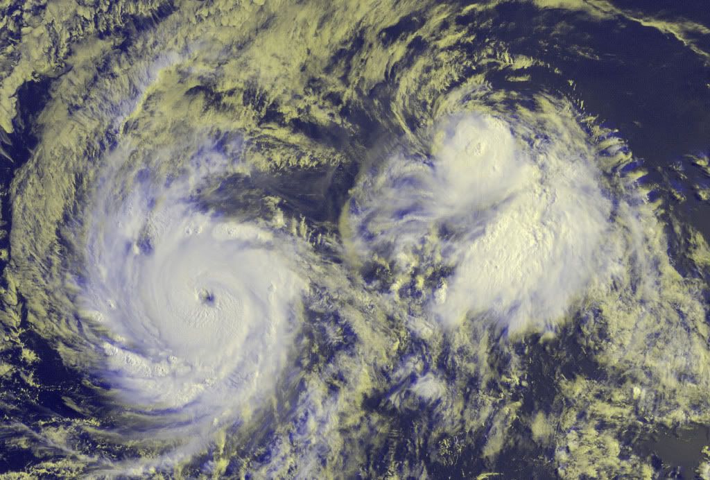
CPAC: TROPICAL DEPRESSION FELICIA (08E)

Moderator: S2k Moderators

Message
Author
Derek Ortt

Re:

#121 Postby Derek Ortt » Wed Aug 05, 2009 12:20 pm

brunota2003 wrote:The POD for "tomorrow" has not been released yet (is usually released around 9 am...the last one out was yesterday, today's hasnt been issued yet...........and it is 1 pm). Someone keep an eye on that!


thats because there are likely to be flights added on it
0 likes   

CrazyC83
Professional-Met
Professional-Met
Posts: 34001
Joined: Tue Mar 07, 2006 11:57 pm
Location: Deep South, for the first time!

#122 Postby CrazyC83 » Wed Aug 05, 2009 12:27 pm

Looks to be about 110 kt right now.
0 likes   

User avatar
HURAKAN
Professional-Met
Professional-Met
Posts: 46086
Age: 38
Joined: Thu May 20, 2004 4:34 pm
Location: Key West, FL
Contact:

Re: EPAC: HURRICANE FELICIA (08E)

#123 Postby HURAKAN » Wed Aug 05, 2009 12:30 pm

Issued: Aug 05, 2009 4:00 AM HST

Synopsis
Trade wind speeds will be slightly stronger during the next few days as the surface high located far north northeast of the aloha state shifts closer to the islands. Expect relatively dry conditions to prevail across most leeward areas of the smaller islands, while windward and mauka sections of the state will continue to have scattered showers through the rest of the work week.

Discussion
A 1030 mb surface high centered near 37°N 150°W, or less than 1200 miles north northeast Honolulu, is moving slowly southwestward. The tightening pressure gradient south of this feature is maintaining moderate to locally fresh trade winds across the state. These stronger trade wind speeds will likely continue through the end of this week. Relatively dry trade wind wind weather is also expected to continue through the remainder of the work week. The latest upper air soundings from around 200 am HST this morning indicated pw values of 1.3 to 1.4 inches. This should keep most of the fast moving showers carried by the trades relatively light across the state.

Examples of the highest rainfall totals at gages across the state for the 12 hour period ending at 200 am HST by island include, 0.25 inches at Mount Waialeale on Kauai, 0.01 inches at Waimanalo and South Fork Kaukonahua on Oahu, 0.03 inches at kamalo on Molokai, 0.07 inches at West Wailuaiki on Maui, and 0.30 inches at Glenwood on the Big Island.

The GFS model continues to indicate a weak upper tropospheric low will develop just north of the state by Friday. As a result, the trade wind inversion will likely weaken, while moisture may be transported up from the south. However, other models keep the moisture confined just south of most of the islands. Because of this and the relative weakness of the low aloft, the gridded forecast continues to indicate only a slight increase in shower activity heading into the weekend, with most of the increase in showers over the windward Big Island.

In the extended forecast, we are closely monitoring hurricane Felicia, currently located almost 1800 miles east southeast of Hilo, and tropical storm Enrique, which is nearly 2300 miles east southeast of Hilo. The latest official forecast issued at 1100 pm HST Monday by the National Hurricane Center in Miami, Florida indicates hurricane Felicia will move west of longitude 140°W into the central north Pacific by early Saturday morning. The latest forecast for tropical storm Enrique indicates it will not play a major role in island weather through the next week.

At this time, it is too early to determine the exact track and intensity Felicia will be as it approaches the Hawaiian islands late Sunday or Monday. That said, we are heading into the climatological peak of the central Pacific hurricane season, and Felicia serves as a reminder to always have a hurricane preparedness plan in place during the official central north Pacific hurricane season, which continues through November 30.


Marine
The small craft advisory, SCA, remains posted for the typically breezy channels and coastal waters adjacent to the Big Island and Maui, as well as the Kaiwi Channel. Of the pressure gradient across the state increases more than is anticipated, additional marine zones may need to be added to the SCA later today or tonight. These SCA conditions are expected to continue at least through this weekend.

The current south swell will continue to decline today. Only small to occasionally moderate swells from the southwest are expected through the remainder of this week. Elsewhere, the breezy trades will produce rough and choppy short period waves that will result in moderate sized surf along east facing shores of most Hawaiian islands. An easterly swell produced by hurricane Felicia may begin to affect the east facing shores of the Big Island by Saturday night or Sunday morning. Based on the latest output from the north Pacific hurricane version of the wave watch iii model, this swell will build during the day on Sunday, likely producing surf well in excess of the high surf advisory threshold of 8 feet along east facing shores on the Big Island. This large swell may also spread to east facing shores of the smaller Hawaiian islands from late Sunday through Monday.

Watches/Warnings/Advisories
Small craft advisory through tonight for Maalaea Bay, the waters south of the Big Island, as well as the kaiwi, Pailolo and Alenuihaha channels.


FORECASTER HOUSTON
0 likes   

User avatar
masaji79
Tropical Storm
Tropical Storm
Posts: 183
Joined: Sun Dec 02, 2007 12:36 am
Location: Las Vegas, Nevada

Re: EPAC: HURRICANE FELICIA (08E)

#124 Postby masaji79 » Wed Aug 05, 2009 12:30 pm

Night Tide wrote:This isn't looking good, as I have a sister who lives in Hawaii.

I thought I heard the news this morning say Hawaii will probably avoid a direct hit, but I don't know. It's worrying me.


Me too, my whole family live in Hawaii, so I am keeping an eye on Felicia. I was visiting my family on the Big Island back in '07 when Flossie made a close call. It did get really close before fizzling out.
0 likes   

Ed Mahmoud

Re: Re:

#125 Postby Ed Mahmoud » Wed Aug 05, 2009 12:44 pm

Derek Ortt wrote:
brunota2003 wrote:The POD for "tomorrow" has not been released yet (is usually released around 9 am...the last one out was yesterday, today's hasnt been issued yet...........and it is 1 pm). Someone keep an eye on that!


thats because there are likely to be flights added on it


6 hour fixes starting Friday. That probably means two planes, at least.


I wonder if Captain Mitchell will be aboard?

Image
0 likes   

Ed Mahmoud

Re: EPAC: HURRICANE FELICIA (08E)

#126 Postby Ed Mahmoud » Wed Aug 05, 2009 12:51 pm

GFS- direct hit, but probably just a tropical storm, and not a strong one at that...

Image
0 likes   

User avatar
cycloneye
Admin
Admin
Posts: 143867
Age: 68
Joined: Thu Oct 10, 2002 10:54 am
Location: San Juan, Puerto Rico

Re: EPAC: HURRICANE FELICIA (08E)

#127 Postby cycloneye » Wed Aug 05, 2009 1:04 pm

UW - CIMSS
ADVANCED DVORAK TECHNIQUE
ADT-Version 7.2.3
Tropical Cyclone Intensity Algorithm

----- Current Analysis -----
Date : 05 AUG 2009 Time : 170000 UTC
Lat : 14:15:00 N Lon : 129:07:50 W


[b]CI# /Pressure/ Vmax
5.8 / 955.8mb/109.8kt


Final T# Adj T# Raw T#
(3hr avg)
5.8 6.4 6.7

Latitude bias adjustment to MSLP : +3.0mb

Estimated radius of max. wind based on IR : 11 km

Center Temp : -15.2C Cloud Region Temp : -72.8C

Scene Type : EYE

Positioning Method : RING/SPIRAL COMBINATION

Ocean Basin : EAST PACIFIC
Dvorak CI > MSLP Conversion Used : ATLANTIC

Tno/CI Rules : Constraint Limits : 2.7T/12hr
Weakening Flag : OFF
Rapid Dissipation Flag : OFF [/b]
0 likes   

Derek Ortt

Re: EPAC: HURRICANE FELICIA (08E)

#128 Postby Derek Ortt » Wed Aug 05, 2009 1:13 pm

masaji79 wrote:
Night Tide wrote:This isn't looking good, as I have a sister who lives in Hawaii.

I thought I heard the news this morning say Hawaii will probably avoid a direct hit, but I don't know. It's worrying me.


Me too, my whole family live in Hawaii, so I am keeping an eye on Felicia. I was visiting my family on the Big Island back in '07 when Flossie made a close call. It did get really close before fizzling out.


the storm is at least 5-6 days away. No need to panic yet
0 likes   

User avatar
KWT
Category 5
Category 5
Posts: 31415
Joined: Tue Aug 17, 2004 11:02 am
Location: UK!!!

#129 Postby KWT » Wed Aug 05, 2009 1:14 pm

Certainly is a good looking hurricane and it seems that we are going to have to watch for a possible landfall, tohugh hopefully this will do a Daniel.

Nice to see the EPAC finally bursting into a busier spell.
0 likes   

User avatar
MGC
S2K Supporter
S2K Supporter
Posts: 5885
Joined: Sun Mar 23, 2003 9:05 pm
Location: Pass Christian MS, or what is left.

Re: EPAC: HURRICANE FELICIA (08E)

#130 Postby MGC » Wed Aug 05, 2009 1:18 pm

According to the POD, the Gulfstream will be flying to Honolulu. I guess they are going to sample the strength of the ridge. I wonder if I could stowaway? I miss Hawaii......MGC
0 likes   

User avatar
cycloneye
Admin
Admin
Posts: 143867
Age: 68
Joined: Thu Oct 10, 2002 10:54 am
Location: San Juan, Puerto Rico

Re: EPAC: HURRICANE FELICIA (08E)

#131 Postby cycloneye » Wed Aug 05, 2009 1:20 pm

This is changing rapidly upwards.

ADVANCED DVORAK TECHNIQUE
ADT-Version 7.2.3
Tropical Cyclone Intensity Algorithm

----- Current Analysis -----
Date : 05 AUG 2009 Time : 173000 UTC
Lat : 14:12:00 N Lon : 129:05:51 W


CI# /Pressure/ Vmax
6.0 / 951.0mb/115.0kt


Final T# Adj T# Raw T#
(3hr avg)
6.0 6.5 6.7

Latitude bias adjustment to MSLP : +3.0mb

Estimated radius of max. wind based on IR : 14 km

Center Temp : -4.3C Cloud Region Temp : -71.8C

Scene Type : EYE

Positioning Method : RING/SPIRAL COMBINATION

Ocean Basin : EAST PACIFIC
Dvorak CI > MSLP Conversion Used : ATLANTIC

Tno/CI Rules : Constraint Limits : 2.7T/12hr
Weakening Flag : OFF
Rapid Dissipation Flag : OFF
0 likes   

User avatar
somethingfunny
ChatStaff
ChatStaff
Posts: 3926
Age: 36
Joined: Thu May 31, 2007 10:30 pm
Location: McKinney, Texas

Re: EPAC: HURRICANE FELICIA (08E)

#132 Postby somethingfunny » Wed Aug 05, 2009 1:21 pm

Oh my. Category 4 at 2pm PDT?
0 likes   

User avatar
srainhoutx
S2K Supporter
S2K Supporter
Posts: 6919
Age: 67
Joined: Sun Jan 14, 2007 11:34 am
Location: Haywood County, NC
Contact:

Re: EPAC: HURRICANE FELICIA (08E)

#133 Postby srainhoutx » Wed Aug 05, 2009 1:25 pm

Image
0 likes   

CrazyC83
Professional-Met
Professional-Met
Posts: 34001
Joined: Tue Mar 07, 2006 11:57 pm
Location: Deep South, for the first time!

#134 Postby CrazyC83 » Wed Aug 05, 2009 1:25 pm

BT at 1800Z: 110 kt

EP, 08, 2009080518, , BEST, 0, 141N, 1293W, 110, 952, HU, 34, NEQ, 105, 105, 90, 90,
0 likes   

CrazyC83
Professional-Met
Professional-Met
Posts: 34001
Joined: Tue Mar 07, 2006 11:57 pm
Location: Deep South, for the first time!

Re: EPAC: HURRICANE FELICIA (08E)

#135 Postby CrazyC83 » Wed Aug 05, 2009 1:41 pm

Still climbing.

UW - CIMSS
ADVANCED DVORAK TECHNIQUE
ADT-Version 7.2.3
Tropical Cyclone Intensity Algorithm

----- Current Analysis -----
Date : 05 AUG 2009 Time : 180000 UTC
Lat : 14:15:00 N Lon : 129:16:17 W


CI# /Pressure/ Vmax
6.2 / 945.8mb/119.8kt


Final T# Adj T# Raw T#
(3hr avg)
6.2 6.6 6.6

Latitude bias adjustment to MSLP : +3.0mb

Estimated radius of max. wind based on IR :N/A km

Center Temp : +3.1C Cloud Region Temp : -70.3C

Scene Type : EYE

Positioning Method : RING/SPIRAL COMBINATION

Ocean Basin : EAST PACIFIC
Dvorak CI > MSLP Conversion Used : ATLANTIC

Tno/CI Rules : Constraint Limits : NO LIMIT
Weakening Flag : OFF
Rapid Dissipation Flag : OFF
0 likes   

User avatar
HURAKAN
Professional-Met
Professional-Met
Posts: 46086
Age: 38
Joined: Thu May 20, 2004 4:34 pm
Location: Key West, FL
Contact:

#136 Postby HURAKAN » Wed Aug 05, 2009 2:02 pm

Image

Image

Ferocious Felicia
0 likes   

RL3AO
Moderator-Pro Met
Moderator-Pro Met
Posts: 16308
Joined: Thu Jun 14, 2007 10:03 pm
Location: NC

Re: EPAC: HURRICANE FELICIA (08E)

#137 Postby RL3AO » Wed Aug 05, 2009 2:12 pm

FWIW, it passed the seven screening tests for an annular storm. It is kinda taking on the appearance, but isn't there yet.

## ANNULAR HURRICANE INDEX (AHI) EP082009 FELICIA 08/05/09 18 UTC ##
## PASSED SCREENING STEP, MIGHT BE ANNULAR, CALCULATE AHI FROM DISCRIMINANT ANALYSIS ##
## AHI= 1 (AHI OF 100 IS BEST FIT TO ANN. STRUC., 1 IS MARGINAL, 0 IS NOT ANNULAR) ##
## ANNULAR INDEX RAN NORMALLY
0 likes   

User avatar
cycloneye
Admin
Admin
Posts: 143867
Age: 68
Joined: Thu Oct 10, 2002 10:54 am
Location: San Juan, Puerto Rico

Re: EPAC: HURRICANE FELICIA (08E)

#138 Postby cycloneye » Wed Aug 05, 2009 2:20 pm

The ADT continues to climb.Cat 4

UW - CIMSS
ADVANCED DVORAK TECHNIQUE
ADT-Version 7.2.3
Tropical Cyclone Intensity Algorithm

----- Current Analysis -----
Date : 05 AUG 2009 Time : 183000 UTC
Lat : 14:12:00 N Lon : 129:20:33 W


[b]CI# /Pressure/ Vmax
6.4 / 940.6mb/124.6kt


Final T# Adj T# Raw T#
(3hr avg)
6.4 6.4 6.4

Latitude bias adjustment to MSLP : +3.0mb

Estimated radius of max. wind based on IR : 22 km

Center Temp : +4.5C Cloud Region Temp : -68.2C

Scene Type : EYE

Positioning Method : RING/SPIRAL COMBINATION

Ocean Basin : EAST PACIFIC
Dvorak CI > MSLP Conversion Used : ATLANTIC

Tno/CI Rules : Constraint Limits : NO LIMIT
Weakening Flag : OFF
Rapid Dissipation Flag : OFF


[/b]
0 likes   

Derek Ortt

#139 Postby Derek Ortt » Wed Aug 05, 2009 2:22 pm

However, the raw has been dropping. This may signal that the intensity should now level off for a few hours

I suspect an EWRC will start within the next 12 hours
0 likes   

CrazyC83
Professional-Met
Professional-Met
Posts: 34001
Joined: Tue Mar 07, 2006 11:57 pm
Location: Deep South, for the first time!

#140 Postby CrazyC83 » Wed Aug 05, 2009 2:24 pm

I wonder what they will set the intensity at for the next advisory? Could they go all the way to 120-125 kt?
0 likes   


Return to “2009”

Who is online

Users browsing this forum: No registered users and 30 guests