Issued: Aug 05, 2009 4:00 AM HSTSynopsis
Trade wind speeds will be slightly stronger during the next few days as the surface high located far north northeast of the aloha state shifts closer to the islands. Expect relatively dry conditions to prevail across most leeward areas of the smaller islands, while windward and mauka sections of the state will continue to have scattered showers through the rest of the work week.
Discussion
A 1030 mb surface high centered near 37°N 150°W, or less than 1200 miles north northeast Honolulu, is moving slowly southwestward. The tightening pressure gradient south of this feature is maintaining moderate to locally fresh trade winds across the state. These stronger trade wind speeds will likely continue through the end of this week. Relatively dry trade wind wind weather is also expected to continue through the remainder of the work week. The latest upper air soundings from around 200 am HST this morning indicated pw values of 1.3 to 1.4 inches. This should keep most of the fast moving showers carried by the trades relatively light across the state.
Examples of the highest rainfall totals at gages across the state for the 12 hour period ending at 200 am HST by island include, 0.25 inches at Mount Waialeale on Kauai, 0.01 inches at Waimanalo and South Fork Kaukonahua on Oahu, 0.03 inches at kamalo on Molokai, 0.07 inches at West Wailuaiki on Maui, and 0.30 inches at Glenwood on the Big Island.
The GFS model continues to indicate a weak upper tropospheric low will develop just north of the state by Friday. As a result, the trade wind inversion will likely weaken, while moisture may be transported up from the south. However, other models keep the moisture confined just south of most of the islands. Because of this and the relative weakness of the low aloft, the gridded forecast continues to indicate only a slight increase in shower activity heading into the weekend, with most of the increase in showers over the windward Big Island.
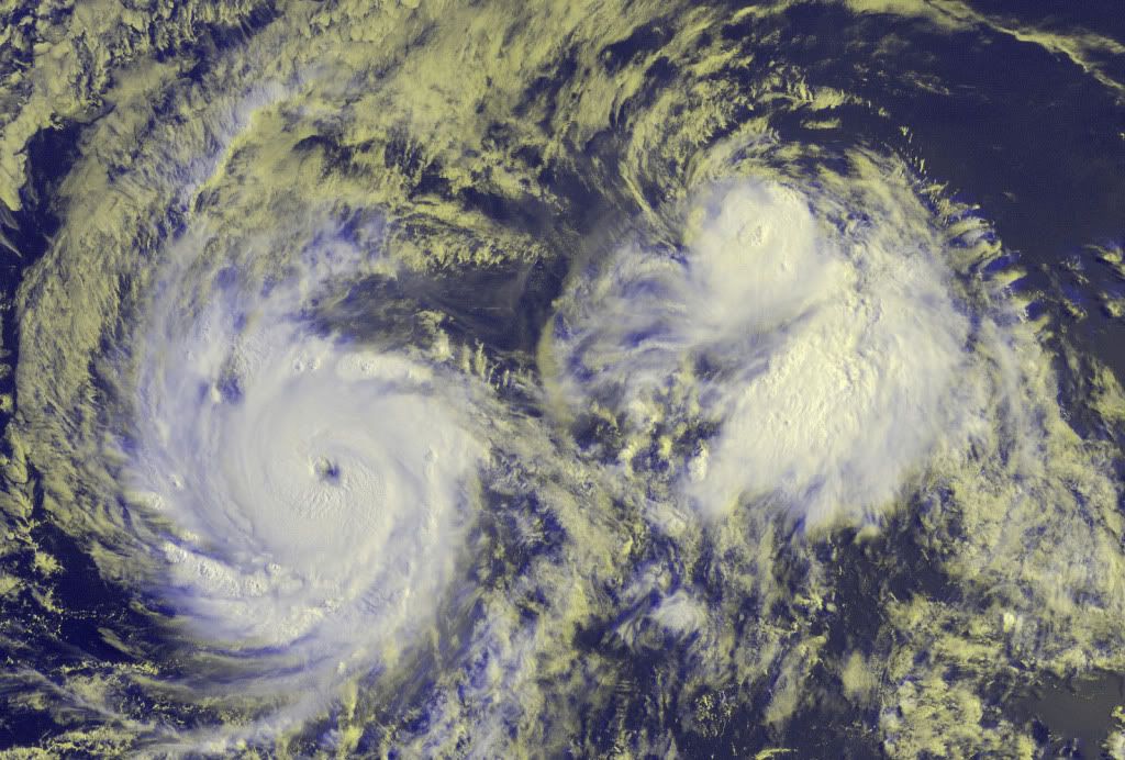
In the extended forecast, we are closely monitoring hurricane Felicia, currently located almost 1800 miles east southeast of Hilo, and tropical storm Enrique, which is nearly 2300 miles east southeast of Hilo. The latest official forecast issued at 1100 pm HST Monday by the National Hurricane Center in Miami, Florida indicates hurricane Felicia will move west of longitude 140°W into the central north Pacific by early Saturday morning. The latest forecast for tropical storm Enrique indicates it will not play a major role in island weather through the next week.
At this time, it is too early to determine the exact track and intensity Felicia will be as it approaches the Hawaiian islands late Sunday or Monday. That said, we are heading into the climatological peak of the central Pacific hurricane season, and Felicia serves as a reminder to always have a hurricane preparedness plan in place during the official central north Pacific hurricane season, which continues through November 30.Marine
The small craft advisory, SCA, remains posted for the typically breezy channels and coastal waters adjacent to the Big Island and Maui, as well as the Kaiwi Channel. Of the pressure gradient across the state increases more than is anticipated, additional marine zones may need to be added to the SCA later today or tonight. These SCA conditions are expected to continue at least through this weekend.
The current south swell will continue to decline today. Only small to occasionally moderate swells from the southwest are expected through the remainder of this week. Elsewhere, the breezy trades will produce rough and choppy short period waves that will result in moderate sized surf along east facing shores of most Hawaiian islands. An easterly swell produced by hurricane Felicia may begin to affect the east facing shores of the Big Island by Saturday night or Sunday morning. Based on the latest output from the north Pacific hurricane version of the wave watch iii model, this swell will build during the day on Sunday, likely producing surf well in excess of the high surf advisory threshold of 8 feet along east facing shores on the Big Island. This large swell may also spread to east facing shores of the smaller Hawaiian islands from late Sunday through Monday.
Watches/Warnings/Advisories
Small craft advisory through tonight for Maalaea Bay, the waters south of the Big Island, as well as the kaiwi, Pailolo and Alenuihaha channels.
FORECASTER HOUSTON