Disturbance In Eastern Caribbean.

This is the general tropical discussion area. Anyone can take their shot at predicting a storms path.

Moderator: S2k Moderators

Forum rules

The posts in this forum are NOT official forecasts and should not be used as such. They are just the opinion of the poster and may or may not be backed by sound meteorological data. They are NOT endorsed by any professional institution or STORM2K. For official information, please refer to products from the National Hurricane Center and National Weather Service.

Help Support Storm2K
Message
Author
Aric Dunn
Category 5
Category 5
Posts: 21238
Age: 42
Joined: Sun Sep 19, 2004 9:58 pm
Location: Ready for the Chase.
Contact:

Re: Re:

#201 Postby Aric Dunn » Mon Aug 10, 2009 3:00 pm

vacanechaser wrote:
ROCK wrote:
Scorpion wrote:Should be Code Orange at 8


keeps this up yes, funny how not one model sniffed this out if it truly does develope...looking good right now.....


not so fast.. i noticed that the 12z GFDL picked up on it... 126hrs out...

Image


See it just off the east coast of fla..


Jesse V. Bass III
http://www.vastormphoto.com
Hurricane Intercept Research Team


yeah jesse i see that .. not sure if its the waves combined that the gfdl develops which is interesting since since its initializing on 99l so the resolution of anything is going to be much lower which means the gfdl sees a much more substantial system than what its showing..
0 likes   

Sanibel
Category 5
Category 5
Posts: 10375
Joined: Mon Aug 30, 2004 11:06 pm
Location: Offshore SW Florida

Re: Disturbance East Of Windward Islands.

#202 Postby Sanibel » Mon Aug 10, 2009 3:00 pm

Does it lose convection again or maintain? Hint of curvature there:


Image
0 likes   

User avatar
Gustywind
Category 5
Category 5
Posts: 12334
Joined: Mon Sep 03, 2007 7:29 am
Location: Baie-Mahault, GUADELOUPE

#203 Postby Gustywind » Mon Aug 10, 2009 3:01 pm

Image
0 likes   

User avatar
ROCK
Category 5
Category 5
Posts: 9483
Age: 54
Joined: Tue Aug 17, 2004 7:30 am
Location: Kemah, Texas

Re: Re:

#204 Postby ROCK » Mon Aug 10, 2009 3:03 pm

wxman57 wrote:
ROCK wrote:
hmm your right...it better start stair stepping soon to gain some lat if it wants to go to EC...


That EC forecast is for the little vorticity center east of this disturbance. It's farther north.


thanks WXMN57....I see that now....dont see much shear in the carib right now though.

http://cimss.ssec.wisc.edu/tropic/real- ... g8sht.html


steering would suggest a westward track so I agree with you on that...

http://cimss.ssec.wisc.edu/tropic/real- ... 8dlm1.html
0 likes   

User avatar
vacanechaser
Category 5
Category 5
Posts: 1461
Joined: Wed Dec 03, 2003 9:34 pm
Location: Portsmouth, Va
Contact:

Re: Re:

#205 Postby vacanechaser » Mon Aug 10, 2009 3:07 pm

Aric Dunn wrote:
vacanechaser wrote:
ROCK wrote:
keeps this up yes, funny how not one model sniffed this out if it truly does develope...looking good right now.....


not so fast.. i noticed that the 12z GFDL picked up on it... 126hrs out...

Image


See it just off the east coast of fla..


Jesse V. Bass III
http://www.vastormphoto.com
Hurricane Intercept Research Team


yeah jesse i see that .. not sure if its the waves combined that the gfdl develops which is interesting since since its initializing on 99l so the resolution of anything is going to be much lower which means the gfdl sees a much more substantial system than what its showing..


my thoughts exactly aric... either way, the gfdl picks up on it and seems to take it off to the northwest or west northwest... didnt say it had to happen...just pointed it out that it was showing up on the model run... whether or not it is the same system, or the other just behind it, who knows with the resolution...


Jesse V. Bass III
http://www.vastormphoto.com
Hurricane Intercept Research Team
0 likes   

User avatar
ROCK
Category 5
Category 5
Posts: 9483
Age: 54
Joined: Tue Aug 17, 2004 7:30 am
Location: Kemah, Texas

Re: Disturbance East Of Windward Islands.

#206 Postby ROCK » Mon Aug 10, 2009 3:30 pm

looking good before sundown....last burst really taking off. I think its made it to the surface...need to see a scat to know for sure.....looks like it to me though....
0 likes   

Ed Mahmoud

Re: Disturbance East Of Windward Islands.

#207 Postby Ed Mahmoud » Mon Aug 10, 2009 3:33 pm

Its coming right at us!!!!


Image
0 likes   

User avatar
ROCK
Category 5
Category 5
Posts: 9483
Age: 54
Joined: Tue Aug 17, 2004 7:30 am
Location: Kemah, Texas

Re: Disturbance East Of Windward Islands.

#208 Postby ROCK » Mon Aug 10, 2009 3:35 pm

nice one ED....thank goodness we have the westerlies to save us.... :lol:
0 likes   

User avatar
fwbbreeze
S2K Supporter
S2K Supporter
Posts: 896
Joined: Sun Mar 21, 2004 10:09 pm
Location: Fort Walton Beach, FL

Re: Disturbance East Of Windward Islands.

#209 Postby fwbbreeze » Mon Aug 10, 2009 3:41 pm

latest ob from Bridgetown, Barbados shows 29.85 and falling with a N wind.

http://www.weather.com/outlook/travel/businesstraveler/local/BBXX0001

29.85 equates to about 1011 mb right? Someone correct me please if I am wrong :)
0 likes   

User avatar
ROCK
Category 5
Category 5
Posts: 9483
Age: 54
Joined: Tue Aug 17, 2004 7:30 am
Location: Kemah, Texas

Re: Disturbance East Of Windward Islands.

#210 Postby ROCK » Mon Aug 10, 2009 3:51 pm

fwbbreeze wrote:latest ob from Bridgetown, Barbados shows 29.85 and falling with a N wind.

http://www.weather.com/outlook/travel/businesstraveler/local/BBXX0001

29.85 equates to about 1011 mb right? Someone correct me please if I am wrong :)


close enough.... :D
0 likes   

User avatar
HURAKAN
Professional-Met
Professional-Met
Posts: 46086
Age: 38
Joined: Thu May 20, 2004 4:34 pm
Location: Key West, FL
Contact:

#211 Postby HURAKAN » Mon Aug 10, 2009 3:53 pm

Image

It will be interesting to see how the wind changes in Barbados as the disturbance moves westward.
0 likes   

User avatar
Emmett_Brown
Category 5
Category 5
Posts: 1432
Joined: Wed Aug 24, 2005 9:10 pm
Location: Sarasota FL

Re: Disturbance East Of Windward Islands.

#212 Postby Emmett_Brown » Mon Aug 10, 2009 4:19 pm

LLC visible:

Image
0 likes   

User avatar
Gustywind
Category 5
Category 5
Posts: 12334
Joined: Mon Sep 03, 2007 7:29 am
Location: Baie-Mahault, GUADELOUPE

#213 Postby Gustywind » Mon Aug 10, 2009 4:22 pm

Current Weather Conditions:
Grantley Adams, Barbados
(TBPB) 13-04N 059-29W 56M

--------------------------------------------------------------------------------

Conditions at Aug 10, 2009 - 05:30 PM EDTAug 10, 2009 - 04:30 PM CDTAug 10, 2009 - 03:30 PM MDTAug 10, 2009 - 02:30 PM PDTAug 10, 2009 - 01:30 PM ADTAug 10, 2009 - 12:30 PM HDT
2009.08.10 2130 UTC
Wind from the NNE (020 degrees) at 16 MPH (14 KT)
Visibility 3 mile(s)
Sky conditions mostly cloudy
Weather Light rain
Cumulonimbus clouds observed
Temperature 78 F (26 C)
Dew Point 77 F (25 C)
Relative Humidity 94%
Pressure (altimeter) 29.85 in. Hg (1011 hPa)
ob TBPB 102130Z 02014KT 6000 -RA SCT010CB BKN100 26/25 Q1011 CB ALL QUADS

--------------------------------------------------------------------------------

24 Hour Summary
Time
EDT (UTC) Temperature
F (C) Dew Point
F (C) Pressure
Inches (hPa) Wind
MPH Weather
Latest 5 PM (21) Aug 10 78 (26) 77 (25) 29.85 (1011) NNE 16 light rain
4 PM (20) Aug 10 78 (26) 77 (25) 29.85 (1011) N 15 thunder in the vicinity
3 PM (19) Aug 10 77 (25) 77 (25) 29.88 (1012) N 8
2 PM (18) Aug 10 77 (25) 77 (25) 29.88 (1012) NNW 7 rain with thunder
1 PM (17) Aug 10 75 (24) 73 (23) 29.91 (1013) N 14 rain with thunder
Noon (16) Aug 10 77 (25) 75 (24) 29.94 (1014) N 13 rain with thunder
11 AM (15) Aug 10 77 (25) 75 (24) 29.94 (1014) N 12 rain with thunder
10 AM (14) Aug 10 78 (26) 77 (25) 29.94 (1014) N 6 light rain showers
9 AM (13) Aug 10 77 (25) 75 (24) 29.97 (1015) Variable 3 rain with thunder
8 AM (12) Aug 10 77 (25) 77 (25) 29.97 (1015) E 3 rain with thunder
7 AM (11) Aug 10 77 (25) 75 (24) 29.94 (1014) N 6 rain with thunder
6 AM (10) Aug 10 77 (25) 75 (24) 29.94 (1014) heavy rain showers
5 AM (9) Aug 10 77 (25) 75 (24) 29.91 (1013) NNW 5 light rain showers
4 AM (8) Aug 10 78 (26) 75 (24) 29.91 (1013) ENE 7
3 AM (7) Aug 10 77 (25) 73 (23) 29.91 (1013) N 5
2 AM (6) Aug 10 78 (26) 75 (24) 29.91 (1013) NE 8
1 AM (5) Aug 10 78 (26) 75 (24) 29.94 (1014) NE 8
Midnight (4) Aug 10 80 (27) 75 (24) 29.94 (1014) ENE 8
11 PM (3) Aug 09 80 (27) 75 (24) 29.97 (1015) ENE 8
10 PM (2) Aug 09 78 (26) 73 (23) 29.97 (1015) E 8
9 PM (1) Aug 09 78 (26) 73 (23) 29.97 (1015) NE 8
8 PM (0) Aug 09 78 (26) 73 (23) 29.94 (1014) NE 7
7 PM (23) Aug 09 78 (26) 75 (24) 29.94 (1014) ENE 8
Oldest 6 PM (22) Aug 09 80 (27) 75 (24) 29.94 (1014) ENE 12
Time
EDT (UTC) Temperature
F(C) Dew Point
F(C) Pressure
Inches(hPa) Wind
(MPH) Weather
0 likes   

User avatar
MGC
S2K Supporter
S2K Supporter
Posts: 5885
Joined: Sun Mar 23, 2003 9:05 pm
Location: Pass Christian MS, or what is left.

Re: Disturbance East Of Windward Islands.

#214 Postby MGC » Mon Aug 10, 2009 4:31 pm

I don't know....just looked like it barfed a bunch of outflow boundries....MGC
0 likes   

Sanibel
Category 5
Category 5
Posts: 10375
Joined: Mon Aug 30, 2004 11:06 pm
Location: Offshore SW Florida

Re: Disturbance East Of Windward Islands.

#215 Postby Sanibel » Mon Aug 10, 2009 4:34 pm

Nice thunderstorm over us right now. The season has turned. Rainy season rains finally came our direction on the Bermuda High establishing itself.

This disturbance is still compressed under the synoptic above it. I agree with Dean that if it made it this far under unfavorable conditions that once it gets a more NW tack it could explode.

You can see the "S" curve in it already.

Strangely enough it is still warm-topped so don't be surprised if it fades again.
0 likes   

User avatar
cycloneye
Admin
Admin
Posts: 143879
Age: 68
Joined: Thu Oct 10, 2002 10:54 am
Location: San Juan, Puerto Rico

Re: Disturbance East Of Windward Islands.

#216 Postby cycloneye » Mon Aug 10, 2009 5:06 pm

For those members that dont live in the Eastern Caribbean and want to know what is going on in the islands with the observations as this wave moves thru,you can go to our Eastern Caribbean tent thread at Weather Attic forum.You can see many web cams at the first post of thread.

Link to Eastern Caribbean Thread

viewtopic.php?f=20&t=85676&start=0
0 likes   

User avatar
wxman57
Moderator-Pro Met
Moderator-Pro Met
Posts: 22951
Age: 67
Joined: Sat Jun 21, 2003 8:06 pm
Location: Houston, TX (southwest)

Re: Disturbance East Of Windward Islands.

#217 Postby wxman57 » Mon Aug 10, 2009 6:04 pm

Looked at it closely this afternoon. GFS takes the vorticity due west into Honduras in 3.5 days, staying near or south of 15N. We think the squalls will stay well south of the islands of the NE Caribbean and the Greater Antilles.

In addition, GFS indicates an accelerating westerly forward speed from around 12-13 kts to start with to up to 22 kts in 48-72 hours. Acceleration = low-level divergence = diminishing thunderstorms. That starts at about 24 hours out. So its best chance of any development is tonight/tomorrow. We're estimating development chances at 10% (that's 90% chance it won't develop).

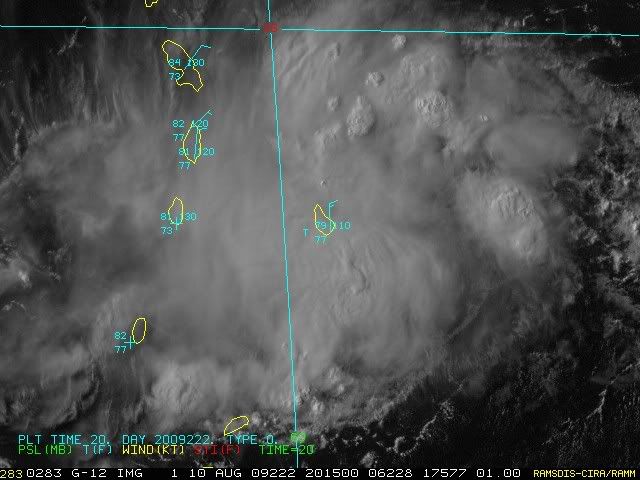
Here's a current surface plot/satellite. As you can see, not much in the way of wind associated with the disturbance:

Image
0 likes   

User avatar
cycloneye
Admin
Admin
Posts: 143879
Age: 68
Joined: Thu Oct 10, 2002 10:54 am
Location: San Juan, Puerto Rico

Re: Disturbance East Of Windward Islands.

#218 Postby cycloneye » Mon Aug 10, 2009 6:46 pm

Code Yellow

000
ABNT20 KNHC 102342
TWOAT
TROPICAL WEATHER OUTLOOK
NWS TPC/NATIONAL HURRICANE CENTER MIAMI FL
800 PM EDT MON AUG 10 2009

FOR THE NORTH ATLANTIC...CARIBBEAN SEA AND THE GULF OF MEXICO...

A SMALL AREA OF LOW PRESSURE ASSOCIATED WITH A TROPICAL WAVE IS
PRODUCING DISORGANIZED SHOWERS AND THUNDERSTORMS NEAR THE WINDWARD
ISLANDS. DEVELOPMENT OF THIS SYSTEM...IF ANY...IS EXPECTED TO BE
SLOW TO OCCUR AS IT MOVES WESTWARD AT 10 TO 15 MPH. LOCALLY HEAVY
RAIN AND GUSTY WINDS SHOULD CONTINUE TO SPREAD OVER PORTIONS OF THE
WINDWARD ISLANDS THROUGH TUESDAY MORNING. THERE IS A LOW CHANCE...
LESS THAN 30 PERCENT...OF THIS SYSTEM BECOMING A TROPICAL CYCLONE
DURING THE NEXT 48 HOURS.

ELSEWHERE...TROPICAL CYCLONE FORMATION IS NOT EXPECTED DURING THE
NEXT 48 HOURS.

$$
FORECASTER ROBERTS/BROWN

Image
0 likes   

Kennethb
Category 2
Category 2
Posts: 505
Joined: Thu Aug 14, 2003 7:15 am
Location: Baton Rouge

#219 Postby Kennethb » Mon Aug 10, 2009 7:21 pm

Hard to believe this is not an official invest yet. And keep in mind the 40th anniversary date a week from today.
0 likes   

User avatar
wxman57
Moderator-Pro Met
Moderator-Pro Met
Posts: 22951
Age: 67
Joined: Sat Jun 21, 2003 8:06 pm
Location: Houston, TX (southwest)

Re: Disturbance East Of Windward Islands.

#220 Postby wxman57 » Mon Aug 10, 2009 7:27 pm

Convection has been decreasing past 3-4 hours now. It may be missing its opportunity for development tonight.
0 likes   


Return to “Talkin' Tropics”

Who is online

Users browsing this forum: Google Adsense [Bot], KeysRedWine and 188 guests