ATL: TROPICAL DEPRESSION ANA (02L)

Moderator: S2k Moderators

Message
Author
User avatar
Evil Jeremy
S2K Supporter
S2K Supporter
Posts: 5463
Age: 32
Joined: Mon Apr 10, 2006 2:10 pm
Location: Los Angeles, CA

Re: ATL: TROPICAL DEPRESSION TWO (Models)

#701 Postby Evil Jeremy » Wed Aug 12, 2009 2:31 pm

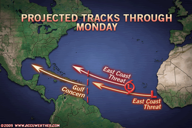
Blown_away wrote:I guess the NHC is not putting to much weight in the GFS,GFDL, and Ukmet solutions, these models keep trending more W and S with each run.


The NHC made a note of the UKMET in their latest discussion, calling it an "alternative scenario", but it is suprising how they are not putting weight on the GFS and GFDL. They seem to be paying attention to the GFDL's sister model, HWRF. I wonder if the HWRF is going to end up replacing the GFDL at one point.
0 likes   

User avatar
HURAKAN
Professional-Met
Professional-Met
Posts: 46086
Age: 38
Joined: Thu May 20, 2004 4:34 pm
Location: Key West, FL
Contact:

#702 Postby HURAKAN » Wed Aug 12, 2009 2:35 pm

We should expect a burst of convection in the next few hours. Ana-to-be is looking a lot like Irene in 2005. A lot of trouble to get going.
0 likes   

JonathanBelles
Professional-Met
Professional-Met
Posts: 11430
Age: 35
Joined: Sat Dec 24, 2005 9:00 pm
Location: School: Florida State University (Tallahassee, FL) Home: St. Petersburg, Florida
Contact:

#703 Postby JonathanBelles » Wed Aug 12, 2009 2:39 pm

Looks like it is just the daily cycle, I expect the convection to boost back up by tonight.
0 likes   

User avatar
HouTXmetro
Category 5
Category 5
Posts: 3949
Joined: Sun Jun 13, 2004 6:00 pm
Location: District of Columbia, USA

Re: ATL : TROPICAL DEPRESSION TWO

#704 Postby HouTXmetro » Wed Aug 12, 2009 2:42 pm

Is TD2 Diving SW?
0 likes   

Sanibel
Category 5
Category 5
Posts: 10375
Joined: Mon Aug 30, 2004 11:06 pm
Location: Offshore SW Florida

Re: ATL : TROPICAL DEPRESSION TWO

#705 Postby Sanibel » Wed Aug 12, 2009 2:42 pm

Naked spiral allows correct fix near: 14.2 degrees north latitude-34.6 degrees west longitude


Heading near due west.
0 likes   

cpdaman
Category 5
Category 5
Posts: 3131
Joined: Sat Jun 10, 2006 11:44 am
Location: SPB county (gulf stream)

Re: ATL : TROPICAL DEPRESSION TWO

#706 Postby cpdaman » Wed Aug 12, 2009 2:43 pm

looks like a decent LLC ....looks like she started a game of strip poker a bout two hours ago and now her LLC is ready to go "streaking"

ANA you will be useful for sounding the public horn for bill

but seriously any Pro's think that the big african wave and it's "energy" is close enough to impact ANA either directly or indirectly in any way. and what way would that be
0 likes   

User avatar
wxman57
Moderator-Pro Met
Moderator-Pro Met
Posts: 22979
Age: 67
Joined: Sat Jun 21, 2003 8:06 pm
Location: Houston, TX (southwest)

Re: ATL : TROPICAL DEPRESSION TWO

#707 Postby wxman57 » Wed Aug 12, 2009 2:44 pm

Of course, now that it's being upgraded it looks worse than it has for 3 days. Center is now completely exposed.
0 likes   

User avatar
HouTXmetro
Category 5
Category 5
Posts: 3949
Joined: Sun Jun 13, 2004 6:00 pm
Location: District of Columbia, USA

Re: ATL: TROPICAL DEPRESSION TWO (Models)

#708 Postby HouTXmetro » Wed Aug 12, 2009 2:44 pm

Loos like it's taking the Southern route.
0 likes   

User avatar
HURAKAN
Professional-Met
Professional-Met
Posts: 46086
Age: 38
Joined: Thu May 20, 2004 4:34 pm
Location: Key West, FL
Contact:

#709 Postby HURAKAN » Wed Aug 12, 2009 2:44 pm

Image

Accuweather. WOW.
0 likes   

fox13weather
Professional-Met
Professional-Met
Posts: 161
Joined: Tue Sep 20, 2005 7:49 pm

Re:

#710 Postby fox13weather » Wed Aug 12, 2009 2:47 pm

HURAKAN wrote:Image

Accuweather. WOW.


Graphics like that should be banned ...Lets scare the cr*p out of people. We will worry about sound scientific reasoning later...
0 likes   

sandyb
Tropical Storm
Tropical Storm
Posts: 221
Age: 64
Joined: Thu Jul 12, 2007 3:09 pm

Re: ATL: TROPICAL DEPRESSION TWO (Models)

#711 Postby sandyb » Wed Aug 12, 2009 2:49 pm

southern is good...better chance of developing...good chance east coast will be in for it over the next three or so weeks with a 1 - 2 hit
0 likes   

User avatar
Evil Jeremy
S2K Supporter
S2K Supporter
Posts: 5463
Age: 32
Joined: Mon Apr 10, 2006 2:10 pm
Location: Los Angeles, CA

Re: ATL: TROPICAL DEPRESSION TWO (Models)

#712 Postby Evil Jeremy » Wed Aug 12, 2009 2:51 pm

sandyb wrote:southern is good...better chance of developing...good chance east coast will be in for it over the next three or so weeks with a 1 - 2 hit


For those reasons, I would say southern is bad. No one needs a 1-2 punch by the tropics.
0 likes   

User avatar
wxman57
Moderator-Pro Met
Moderator-Pro Met
Posts: 22979
Age: 67
Joined: Sat Jun 21, 2003 8:06 pm
Location: Houston, TX (southwest)

Re:

#713 Postby wxman57 » Wed Aug 12, 2009 2:53 pm

HURAKAN wrote:http://i40.photobucket.com/albums/e244/zdtadmin/page-57.gif

Accuweather. WOW.


Looks very reasonable to me. That's exactly what we're telling our clients. But we don't deal with the general public.
0 likes   

User avatar
Ola
Category 1
Category 1
Posts: 299
Joined: Mon Apr 21, 2003 11:24 pm
Location: Dorado, Puerto Rico

Re: ATL: TROPICAL DEPRESSION TWO (Models)

#714 Postby Ola » Wed Aug 12, 2009 2:54 pm

Evil Jeremy wrote:
sandyb wrote:southern is good...better chance of developing...good chance east coast will be in for it over the next three or so weeks with a 1 - 2 hit


For those reasons, I would say southern is bad. No one needs a 1-2 punch by the tropics.


Dont feed the troll
0 likes   

User avatar
Evil Jeremy
S2K Supporter
S2K Supporter
Posts: 5463
Age: 32
Joined: Mon Apr 10, 2006 2:10 pm
Location: Los Angeles, CA

Re: Re:

#715 Postby Evil Jeremy » Wed Aug 12, 2009 2:54 pm

fox13weather wrote:
HURAKAN wrote:Image

Accuweather. WOW.


Graphics like that should be banned ...Lets scare the cr*p out of people. We will worry about sound scientific reasoning later...


Yesterday Accuweather came up with a graphic that pretty much acted as a 12 day prediction cone for (soon to be) Ana and (soon to be) 90L, and everywhere from Florida to the Carolinas were in that cone. They have guts. Really though, Accuweather needs to stop scaring people for attention.
0 likes   

Cyclone1
Category 5
Category 5
Posts: 2739
Age: 33
Joined: Tue Jun 12, 2007 12:03 pm
Location: Florida

#716 Postby Cyclone1 » Wed Aug 12, 2009 2:54 pm

Thank you Accuweather.
0 likes   

fox13weather
Professional-Met
Professional-Met
Posts: 161
Joined: Tue Sep 20, 2005 7:49 pm

Re: Re:

#717 Postby fox13weather » Wed Aug 12, 2009 2:57 pm

wxman57 wrote:
HURAKAN wrote:http://i40.photobucket.com/albums/e244/zdtadmin/page-57.gif

Accuweather. WOW.


Looks very reasonable to me. That's exactly what we're telling our clients. But we don't deal with the general public.


In that case every wave that comes off Africa is an east coast/ Gulf of Mexico threat. There is enough model spread that calling "Ana" and the wave coming off Africa east coast/Gulf threats is nothing more than attention grabers.
0 likes   

Squarethecircle
Category 5
Category 5
Posts: 2165
Joined: Fri Oct 19, 2007 4:00 pm
Location: Fairfax, VA

#718 Postby Squarethecircle » Wed Aug 12, 2009 2:58 pm

Geez, they can't even affix the word "potential" to those statements? That's my problem with it. If they said that "these storms could eventually pose a problem to the east coast", that's fine, but the graphic (foregoing intentions) basically says "these storms are currently threatening the east coast."
0 likes   

User avatar
wxman57
Moderator-Pro Met
Moderator-Pro Met
Posts: 22979
Age: 67
Joined: Sat Jun 21, 2003 8:06 pm
Location: Houston, TX (southwest)

Re: Re:

#719 Postby wxman57 » Wed Aug 12, 2009 3:00 pm

fox13weather wrote:

In that case every wave that comes off Africa is an east coast/ Gulf of Mexico threat. There is enough model spread that calling "Ana" and the wave coming off Africa east coast/Gulf threats is nothing more than attention grabers.


Yeah, in my video I did mention that the threat could be anywhere from the Gulf Coast to out to sea off the East U.S. Coast. Way too early to tell. But it certainly is a "possible East Coast threat".
0 likes   

User avatar
Emmett_Brown
Category 5
Category 5
Posts: 1432
Joined: Wed Aug 24, 2005 9:10 pm
Location: Sarasota FL

Re: Re:

#720 Postby Emmett_Brown » Wed Aug 12, 2009 3:00 pm

wxman57 wrote:
HURAKAN wrote:http://i40.photobucket.com/albums/e244/zdtadmin/page-57.gif

Accuweather. WOW.


Looks very reasonable to me. That's exactly what we're telling our clients. But we don't deal with the general public.


Wx, quick question; What is your feeling on the trough at the end of the Euro run. Looks kind of shallow to me. Has the Euro handled troughs well this season at long ranges (over or under doing?)

I live on the SE coast, so interested.
0 likes   


Return to “2009”

Who is online

Users browsing this forum: No registered users and 5 guests