
If this develops near the CV Islands, then I think it will recurve very early.
Rarely do we see a system that develops real early make it across.
Sometimes, if it develops near the islands it curves right past the islands.
I can't recall the names in the past that did this, but I think that it has happened more often than not
Strong tropical wave ssw of Cape Verde islands
Moderator: S2k Moderators
Forum rules

The posts in this forum are NOT official forecasts and should not be used as such. They are just the opinion of the poster and may or may not be backed by sound meteorological data. They are NOT endorsed by any professional institution or STORM2K. For official information, please refer to products from the National Hurricane Center and National Weather Service.
-
Ivanhater

- Storm2k Moderator

- Posts: 11166
- Age: 39
- Joined: Fri Jul 01, 2005 8:25 am
- Location: Pensacola
Re:
fci wrote:If this develops near the CV Islands, then I think it will recurve very early.
Rarely do we see a system that develops real early make it across.
Sometimes, if it develops near the islands it curves right past the islands.
I can't recall the names in the past that did this, but I think that it has happened more often than not
It is better to look at the current synopsis than to look at past storms..the models are showing ridging developing across the entire Atlantic at the time this is moving west..I'm not seeing anything to show this being a recurver, at least according to the models now.
Seems the models are showing the strongest ridging without any weakness of the season.
0 likes
-
Wx_Warrior
- Category 5

- Posts: 2718
- Joined: Thu Aug 03, 2006 3:58 pm
- Location: Beaumont, TX
Re: Strong tropical wave SSE of CV islands
Yea and models aren't doing much with this system either.
0 likes
-
Blown Away

- S2K Supporter

- Posts: 10253
- Joined: Wed May 26, 2004 6:17 am
Re: Strong tropical wave SSE of CV islands
Ivanhater wrote:Long-term Synopsis for Wed Aug 26th
8-14 DAY OUTLOOK FOR SEP 03 - 09 2009
DURING WEEK TWO, THE GFS AND CANADIAN BASED ENSEMBLE MEANS FORECAST TROUGHS
OVER WESTERN ALASKA, ALONG THE WEST COAST OF THE CONUS, AND WEAK TROUGHING
ALONG THE APPALACHIANS. SUBTROPICAL RIDGING IS PREDICTED FOR PARTS OF THE
SOUTHWEST U.S. AND OFF THE SOUTHEAST COAST OF THE CONUS. A WEAKNESS IN THIS
SUBTROPICAL RIDGING IS FORECAST FOR THE GULF COAST REGION.
Yeah, the timing of this wave and the ridging off the SE speaks volumes to me.
0 likes
-
Ivanhater
- Storm2k Moderator
- Posts: 11166
- Age: 39
- Joined: Fri Jul 01, 2005 8:25 am
- Location: Pensacola
Re: Strong tropical wave SSE of CV islands
In fact, the models that do develop this, like the CMC and UKMET, all show the ridge building in nicely, as well as the Euro
0 likes
-
cycloneye

- Admin

- Posts: 148737
- Age: 69
- Joined: Thu Oct 10, 2002 10:54 am
- Location: San Juan, Puerto Rico
Re: Strong tropical wave SSE of CV islands
I bring only one example of one system (Hurricane Hugo) that developed near the Cape Verde Islands and made it across the Atlantic.It was a heck strong subtropical ridge at that time that made Hugo make it across.Is all about timing in terms of having a fairly strong ridge as a system moves across the Atlantic.But this year the highs haved not been particulary strong due to the negative NAO (Northern Atlantic Occilation)

0 likes
-
otowntiger
- Category 5
- Posts: 1932
- Joined: Tue Aug 31, 2004 7:06 pm
Re: Strong tropical wave SSE of CV islands
Thats a good point there Cycloneye. Hugo did develop in this same general area, except it doesn't look like he got too strong until more toward the middle Atlantic. Off topic a little, I was looking at some weather video the other day and saw some amazing footage of hurricane Hugo slamming mercilessly into Puerto Rico. I had forgotton how bad you guys got hit there. It seems all the focus is always on South Carolina.cycloneye wrote:I bring only one example of one system (Hurricane Hugo) that developed near the Cape Verde Islands and made it across the Atlantic.It was a heck strong subtropical ridge at that time that made Hugo make it across.Is all about timing in terms of having a fairly strong ridge as a system moves across the Atlantic.But this year the highs haved not been particulary strong due to the negative NAO (Northern Atlantic Occilation)
0 likes
-
Wx_Warrior
- Category 5
- Posts: 2718
- Joined: Thu Aug 03, 2006 3:58 pm
- Location: Beaumont, TX
Re: Strong tropical wave SSE of CV islands
I put 0 ZERO emphasis on CMC....I looked at lastest EURO. Nothing serious there.
0 likes
-
Ivanhater
- Storm2k Moderator
- Posts: 11166
- Age: 39
- Joined: Fri Jul 01, 2005 8:25 am
- Location: Pensacola
Re: Strong tropical wave SSE of CV islands
Wx_Warrior wrote:I put 0 ZERO emphasis on CMC....I looked at lastest EURO. Nothing serious there.
Except for the fact that the usually conservative UKMET develops this as well, and your favorite Euro has been touch and go with this system, yesterday's Euro showing quite a strong system, today a tropical storm...but ALL the models showing a strong ridge building, not weakening while the system moves west...
Yesterday's Euro...

UKMET

Strong looking ridge
Last edited by Ivanhater on Wed Aug 26, 2009 4:32 pm, edited 1 time in total.
0 likes
-
Blown Away
- S2K Supporter
- Posts: 10253
- Joined: Wed May 26, 2004 6:17 am
Re: Strong tropical wave SSE of CV islands
Wx_Warrior wrote:I put 0 ZERO emphasis on CMC....I looked at lastest EURO. Nothing serious there.
Just look at the satellite and you can see a nice big wave that has maintained convection after leaving Africa. The NHC is taking notice. I like the models but don't always put all the eggs in that basket
0 likes
-
Wx_Warrior
- Category 5
- Posts: 2718
- Joined: Thu Aug 03, 2006 3:58 pm
- Location: Beaumont, TX
Re: Strong tropical wave SSE of CV islands
Why reference yesterdays?
Look at the newest EURO.
Another personal aspect is I put no stock in the UKMET either.
Look at the newest EURO.
Another personal aspect is I put no stock in the UKMET either.
0 likes
-
Ivanhater
- Storm2k Moderator
- Posts: 11166
- Age: 39
- Joined: Fri Jul 01, 2005 8:25 am
- Location: Pensacola
Re: Strong tropical wave SSE of CV islands
Wx_Warrior wrote:Why reference yesterdays?
Look at the newest.
Because it has been off and on, yesterday showing a hurricane, this morning nothing, this afternoon a tropical storm, it has not been consistent except for the upper air pattern showing a building ridge, that's the most important thing...
0 likes
-
Wx_Warrior
- Category 5
- Posts: 2718
- Joined: Thu Aug 03, 2006 3:58 pm
- Location: Beaumont, TX
Re: Re:
Ivanhater wrote:fci wrote:If this develops near the CV Islands, then I think it will recurve very early.
Rarely do we see a system that develops real early make it across.
Sometimes, if it develops near the islands it curves right past the islands.
I can't recall the names in the past that did this, but I think that it has happened more often than not
It is better to look at the current synopsis than to look at past storms..the models are showing ridging developing across the entire Atlantic at the time this is moving west..I'm not seeing anything to show this being a recurver, at least according to the models now.
Seems the models are showing the strongest ridging without any weakness of the season.
Say what you want about not looking at past storms but I looked at the past 10 years and ALL storms that were named EAST of 30 curved out to sea and were fish.
Pretty compelling, if you ask me.
If current synopsis were your only guide you would be wrong much of the time given the length of time we are talking about a storm that develops by the CV Islands and the fact that we are wrong a lot of the time in predicting systems.
So, I rely heavily on history and it guides me quite well, particularly when we are surmising what a system will do many days out. Sure, current synopsis is the way to go for short to mid-term prognosticating but I will take history in longer term "guessing" and certainly the evidence is compelling for storms that develop by the CV Islands to recurve and recurve early.
Look it up. You will likely have to go WAY back to find a storm that developed east of 30 (by the CV Islands) that made it across.
0 likes
-
cycloneye
- Admin
- Posts: 148737
- Age: 69
- Joined: Thu Oct 10, 2002 10:54 am
- Location: San Juan, Puerto Rico
Re: Strong tropical wave south of Cape Verde islands
0 likes

The high is stronger then recently at least in the middle of the Atlantic once we reach 72-96hrs so this may keep a W/WNW type track for longer but eventually we will see another weakness form and it will no doubt lift this one out.
Of course you can get the Hugo type hurricanes that manage to make it the whole way across but there look to be still too many weakness at upper levels coming about too often to allow that to happen.
Of course you can get the Hugo type hurricanes that manage to make it the whole way across but there look to be still too many weakness at upper levels coming about too often to allow that to happen.
0 likes
-
cycloneye
- Admin
- Posts: 148737
- Age: 69
- Joined: Thu Oct 10, 2002 10:54 am
- Location: San Juan, Puerto Rico
Re: Strong tropical wave south of Cape Verde islands
This image updates every 15 minutes.It keeps organizing.

Code Orange at 8 PM?
Code Orange at 8 PM?
0 likes
-
Bocadude85

- Category 5
- Posts: 2990
- Age: 39
- Joined: Mon Apr 18, 2005 2:20 pm
- Location: Honolulu,Hi
Re: Re:
fci wrote:Ivanhater wrote:fci wrote:If this develops near the CV Islands, then I think it will recurve very early.
Rarely do we see a system that develops real early make it across.
Sometimes, if it develops near the islands it curves right past the islands.
I can't recall the names in the past that did this, but I think that it has happened more often than not
It is better to look at the current synopsis than to look at past storms..the models are showing ridging developing across the entire Atlantic at the time this is moving west..I'm not seeing anything to show this being a recurver, at least according to the models now.
Seems the models are showing the strongest ridging without any weakness of the season.
Say what you want about not looking at past storms but I looked at the past 10 years and ALL storms that were named EAST of 30 curved out to sea and were fish.
Pretty compelling, if you ask me.
If current synopsis were your only guide you would be wrong much of the time given the length of time we are talking about a storm that develops by the CV Islands and the fact that we are wrong a lot of the time in predicting systems.
So, I rely heavily on history and it guides me quite well, particularly when we are surmising what a system will do many days out. Sure, current synopsis is the way to go for short to mid-term prognosticating but I will take history in longer term "guessing" and certainly the evidence is compelling for storms that develop by the CV Islands to recurve and recurve early.
Look it up. You will likely have to go WAY back to find a storm that developed east of 30 (by the CV Islands) that made it across.
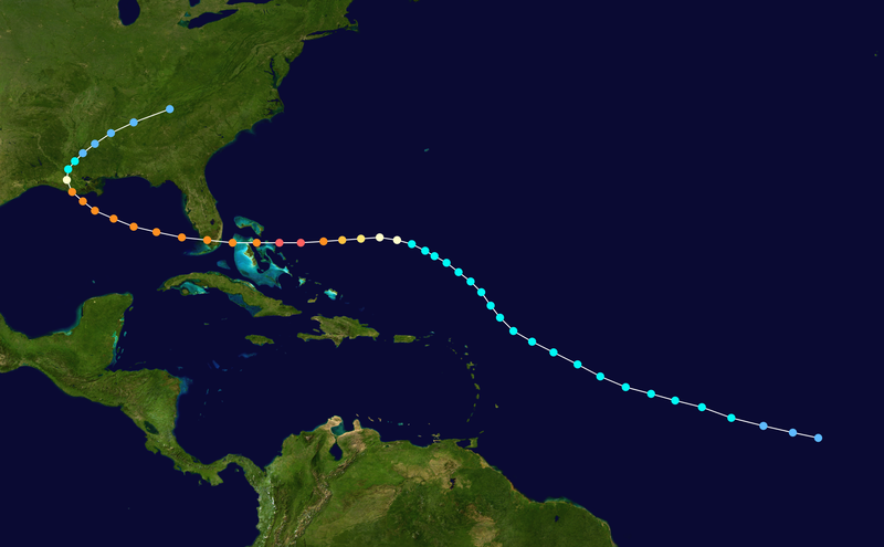
Here are a few storms that formed nears the CV islands and made it across
http://upload.wikimedia.org/wikipedia/commons/thumb/2/27/1947_Fort_Lauderdale_hurricane_track.png/800px-1947_Fort_Lauderdale_hurricane_track.png
http://upload.wikimedia.org/wikipedia/commons/thumb/5/5f/Ike_2008_track.png/800px-Ike_2008_track.png
http://upload.wikimedia.org/wikipedia/commons/thumb/5/5d/1928_Okeechobee_hurricane_track.png/800px-1928_Okeechobee_hurricane_track.png
And these other storms below show what a strong ridge is capable of
http://upload.wikimedia.org/wikipedia/commons/thumb/a/af/Andrew_1992_track.png/800px-Andrew_1992_track.png
http://upload.wikimedia.org/wikipedia/commons/thumb/5/56/Jeanne_2004_track.png/800px-Jeanne_2004_track.png
Last edited by Bocadude85 on Wed Aug 26, 2009 5:28 pm, edited 1 time in total.
0 likes
Who is online
Users browsing this forum: wwizard and 53 guests