Aric Dunn wrote:I still do not see a motion of 300 .. lol
if this goes north of the islands i will be surprised..
? what do you see? what motion?
Moderator: S2k Moderators


Gustywind wrote:Aric Dunn wrote:I still do not see a motion of 300 .. lol
if this goes north of the islands i will be surprised..
? what do you see? what motion?

The posts in this forum are NOT official forecast and should not be used as such. They are just the opinion of the poster and may or may not be backed by sound meteorological data. They are NOT endorsed by any professional institution or storm2k.org. For official information, please refer to the NHC and NWS products.
StormTracker wrote:When will this data start being plugged into the models


Aric Dunn wrote:Gustywind wrote:Aric Dunn wrote:I still do not see a motion of 300 .. lol
if this goes north of the islands i will be surprised..
? what do you see? what motion?
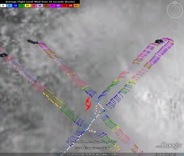
since last night its been moving between WEST and wnw .. over the last 6 hours or so .. of about 285 to 290

gatorcane wrote:The posts in this forum are NOT official forecast and should not be used as such. They are just the opinion of the poster and may or may not be backed by sound meteorological data. They are NOT endorsed by any professional institution or storm2k.org. For official information, please refer to the NHC and NWS products.
Hello Eric I see a movement of 300. This storm continues to look like a classic recurve candidate to me. Should end up recurving to the right of the CONUS by several hundred miles. Again its not a Florida Storm if it becomes a hurricane.

HURAKAN wrote:
Erika looks to be SE of where NHC initiated advisories
HURAKAN wrote:
Erika looks to be SE of where NHC initiated advisories

Users browsing this forum: No registered users and 30 guests