ATL : TROPICAL DEPRESSION ERIKA (06L)

Moderator: S2k Moderators

Message
Author
User avatar
artist
Category 5
Category 5
Posts: 9792
Joined: Mon Jun 06, 2005 3:26 pm
Location: West Palm

Re:

#3661 Postby artist » Wed Sep 02, 2009 9:25 pm

Aquawind wrote:Artist I think it's a Mid Level Circulation you might see on IR2..

http://www.ssd.noaa.gov/goes/flt/t2/loop-ir2.html
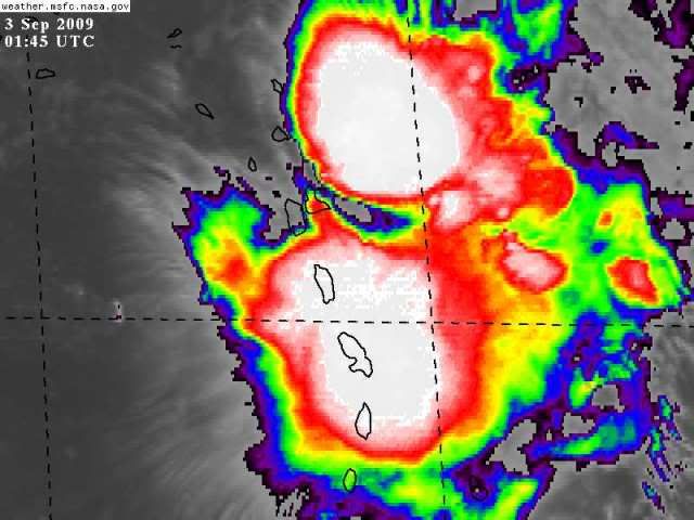
thank you Aquawind! Glad to know OTown and I aren't crazy! lol
0 likes   

User avatar
artist
Category 5
Category 5
Posts: 9792
Joined: Mon Jun 06, 2005 3:26 pm
Location: West Palm

Re: Re:

#3662 Postby artist » Wed Sep 02, 2009 9:28 pm

Air Force Met wrote:
wxman57 wrote:
artist wrote:is anyone else noting that spin she has going now in her far upper right hand corner? Look at it on loop in the enhanced and it is clearly there. 18/56
OTown asked if it was the mlc and hasn't gotten a response either. Anyone?
http://rammb.cira.colostate.edu/ramsdis ... _floater_2


No, don't see it.


I see what he's talking about. Looks like a vort max moving drifting northward. Looks like its sitting b/w 350-450 mb's...20-25K feet. Yet another "bad sign."

so a bad sign as in tearing apart? :)
0 likes   

User avatar
HURAKAN
Professional-Met
Professional-Met
Posts: 46086
Age: 38
Joined: Thu May 20, 2004 4:34 pm
Location: Key West, FL
Contact:

#3663 Postby HURAKAN » Wed Sep 02, 2009 9:29 pm

Image

Heavy rainfall
0 likes   

SapphireSea
Category 1
Category 1
Posts: 430
Joined: Wed Aug 24, 2005 12:13 pm
Location: Miami, FL

Re: Re:

#3664 Postby SapphireSea » Wed Sep 02, 2009 9:32 pm

I see what he's talking about. Looks like a vort max moving drifting northward. Looks like its sitting b/w 350-450 mb's...20-25K feet. Yet another "bad sign."

so a bad sign as in tearing apart? :)


I believe it signifies that shear is causing decoupling of the system at higher layers, the storm has very bad structure, probobly may not have an LLC as we speak.
0 likes   

User avatar
BigA
Professional-Met
Professional-Met
Posts: 1317
Joined: Sun Jul 24, 2005 10:56 pm

#3665 Postby BigA » Wed Sep 02, 2009 9:33 pm

The odd thing is how deceiving appearences can be. If I hadn't known the history of Erika, and someone just showed me the infrared and said "look at this category 1 hurricane," I would believe him/her. Nonetheless, I think this thing is toast, but with the amount of sheer convective energy it has, I don't know if there is any practical difference between a 40 mph tropical storm that brings 10 inches of rain and a tropical disturbance with wind gusts to 40 mph that brings 10 inches of rain.

Perhaps it matters to us so much because tropical cyclones are named.
0 likes   

User avatar
Aquawind
Category 5
Category 5
Posts: 6714
Age: 62
Joined: Mon Jun 16, 2003 10:41 pm
Location: Salisbury, NC
Contact:

#3666 Postby Aquawind » Wed Sep 02, 2009 9:33 pm

Well as AFM mentioned it's not a good sign.. For good organization it needs to be stacked at all levels and this has been far from the case the Erika. Just another sign of competing swirls at different heights..It's far from coming together at the moment..just the opposite.. Now the LLC could still reform under the convection but, everything suggests it wont matter much with all of the shear forecast at the moment..things can change and the models data can be wrong..so we keep watching.
0 likes   

SapphireSea
Category 1
Category 1
Posts: 430
Joined: Wed Aug 24, 2005 12:13 pm
Location: Miami, FL

Re:

#3667 Postby SapphireSea » Wed Sep 02, 2009 9:35 pm

BigA wrote:The odd thing is how deceiving appearences can be. If I hadn't known the history of Erika, and someone just showed me the infrared and said "look at this category 1 hurricane," I would believe him/her. Nonetheless, I think this thing is toast, but with the amount of sheer convective energy it has, I don't know if there is any practical difference between a 40 mph tropical storm that brings 10 inches of rain and a tropical disturbance with wind gusts to 40 mph that brings 10 inches of rain.

Perhaps it matters to us so much because tropical cyclones are named.


In a disorganized convective mass like this, 40mph gusts would be very isolated in heavier bands. A 35kt TS would have a bigger swath of "40mph" winds caused by a true concentrated area of low pressure. Despite what it seems this probobly does have a decent area of 20-25kt winds regardless.
0 likes   

DeanDaDream
Tropical Low
Tropical Low
Posts: 25
Joined: Tue Aug 12, 2008 9:44 pm
Location: Keystone Heights, Florida

Re:

#3668 Postby DeanDaDream » Wed Sep 02, 2009 9:37 pm

HURAKAN wrote:Image

Heavy rainfall


[quote] from Derek Ortt.... Erika forecasts in analysis forum> Of course, if convection keeps firing near the 850mb center found by recon that is approaching Barbuda, and the center reforms there, this entire forecast will need to be chucked tomorrow morning.
0 likes   

fd122
Tropical Depression
Tropical Depression
Posts: 56
Joined: Thu Oct 16, 2008 8:02 am
Location: Antigua, W.I.

Re:

#3669 Postby fd122 » Wed Sep 02, 2009 9:37 pm

HURAKAN wrote:Image

Heavy rainfall


Looking forward to the rain coming soon (hopefully in non destructive amounts).
0 likes   

User avatar
Aquawind
Category 5
Category 5
Posts: 6714
Age: 62
Joined: Mon Jun 16, 2003 10:41 pm
Location: Salisbury, NC
Contact:

Re: Re:

#3670 Postby Aquawind » Wed Sep 02, 2009 9:40 pm

SapphireSea wrote:
BigA wrote:The odd thing is how deceiving appearences can be. If I hadn't known the history of Erika, and someone just showed me the infrared and said "look at this category 1 hurricane," I would believe him/her. Nonetheless, I think this thing is toast, but with the amount of sheer convective energy it has, I don't know if there is any practical difference between a 40 mph tropical storm that brings 10 inches of rain and a tropical disturbance with wind gusts to 40 mph that brings 10 inches of rain.
Perhaps it matters to us so much because tropical cyclones are named.


In a disorganized convective mass like this, 40mph gusts would be very isolated in heavier bands. A 35kt TS would have a bigger swath of "40mph" winds caused by a true concentrated area of low pressure. Despite what it seems this probobly does have a decent area of 20-25kt winds regardless.


Well there is a big difference you have heavy rains and strong winds that last for more than minutes..overtime the combination will weaken structures, plants, tress, ect and they go flying or falling. The combination for extended amount of time makes all the difference and thus the name classification.
0 likes   

User avatar
Bocadude85
Category 5
Category 5
Posts: 2991
Age: 38
Joined: Mon Apr 18, 2005 2:20 pm
Location: Honolulu,Hi

Re: Re:

#3671 Postby Bocadude85 » Wed Sep 02, 2009 9:40 pm

DeanDaDream wrote:
HURAKAN wrote:Image

Heavy rainfall


from Derek Ortt.... Erika forecasts in analysis forum> Of course, if convection keeps firing near the 850mb center found by recon that is approaching Barbuda, and the center reforms there, this entire forecast will need to be chucked tomorrow morning.


Wonder what he means by that.
0 likes   

CrazyC83
Professional-Met
Professional-Met
Posts: 34002
Joined: Tue Mar 07, 2006 11:57 pm
Location: Deep South, for the first time!

#3672 Postby CrazyC83 » Wed Sep 02, 2009 9:41 pm

If this split into two separate systems with two LLC's, which one retains Erika and which becomes TD7/Fred?
0 likes   

User avatar
storms NC
Tropical Storm
Tropical Storm
Posts: 247
Age: 69
Joined: Tue Sep 14, 2004 2:41 pm
Location: Coast of NC & southwest coast of Fla

#3673 Postby storms NC » Wed Sep 02, 2009 9:42 pm

May I ask a question? Can this TS split and redevelop a new LLC over in the east side or Both? And we would have 2 storms that came from 1. Has this ever happen? I haven't look this up. I just seen the WV loop and it went thought my head that it is splitting. Than I read a few post. I am on my way to bed and look to see what was going on. Oh well This is some TS to say the lease :double:
0 likes   

User avatar
Evil Jeremy
S2K Supporter
S2K Supporter
Posts: 5463
Age: 32
Joined: Mon Apr 10, 2006 2:10 pm
Location: Los Angeles, CA

#3674 Postby Evil Jeremy » Wed Sep 02, 2009 9:43 pm

I really doubt Erika will "split" into 2 more storms. More than likely it will just dissolve into itself and die out lol. I asked Derek though if he thought that the center would reform north, and he described it as a "coinflip", hmm.....
0 likes   

User avatar
storms NC
Tropical Storm
Tropical Storm
Posts: 247
Age: 69
Joined: Tue Sep 14, 2004 2:41 pm
Location: Coast of NC & southwest coast of Fla

#3675 Postby storms NC » Wed Sep 02, 2009 9:43 pm

So I am not the only one who thinks this?
0 likes   

SapphireSea
Category 1
Category 1
Posts: 430
Joined: Wed Aug 24, 2005 12:13 pm
Location: Miami, FL

Re:

#3676 Postby SapphireSea » Wed Sep 02, 2009 9:44 pm

CrazyC83 wrote:If this split into two separate systems with two LLC's, which one retains Erika and which becomes TD7/Fred?


I believe since that other vort is in the upper levels, it would form a brand new LLC which would be TD7/Fred. This is definately not the operational LLC they were tracking for Erika. The odds of that vort surviving are less than 1%.
0 likes   

User avatar
Evil Jeremy
S2K Supporter
S2K Supporter
Posts: 5463
Age: 32
Joined: Mon Apr 10, 2006 2:10 pm
Location: Los Angeles, CA

#3677 Postby Evil Jeremy » Wed Sep 02, 2009 9:44 pm

MAXIMUM SUSTAINED WINDS ARE NEAR 40 MPH...65 KM/HR...WITH HIGHER
GUSTS. LITTLE CHANGE IN STRENGTH IS FORECAST DURING THE NEXT 12
HOURS BUT A GRADUAL WEAKENING SHOULD BEGIN THEREFATER.
0 likes   

User avatar
BigA
Professional-Met
Professional-Met
Posts: 1317
Joined: Sun Jul 24, 2005 10:56 pm

#3678 Postby BigA » Wed Sep 02, 2009 9:44 pm

There's an 850 mb center near Barbuda? That's pretty darn close to the surface, is it not, about a mile? I'd be interested to see what recon finds tonight, if any flights are scheduled.
0 likes   

User avatar
Aquawind
Category 5
Category 5
Posts: 6714
Age: 62
Joined: Mon Jun 16, 2003 10:41 pm
Location: Salisbury, NC
Contact:

Re: ATL : TROPICAL STORM ERIKA (06L)

#3679 Postby Aquawind » Wed Sep 02, 2009 9:44 pm

this entire forecast will need to be chucked tomorrow morning.


Maybe in path but, the shear is still forecast..so it could be moot. If it delays the forward progess into a hostile enviroment for the time being..then it may matter because the shear won't last forever..timing is everything..
0 likes   

User avatar
Evil Jeremy
S2K Supporter
S2K Supporter
Posts: 5463
Age: 32
Joined: Mon Apr 10, 2006 2:10 pm
Location: Los Angeles, CA

Re: ATL : TROPICAL STORM ERIKA (06L)

#3680 Postby Evil Jeremy » Wed Sep 02, 2009 9:46 pm

Tidbits from tonight's discussion:

ERIKA IS BARELY A TROPICAL STORM. DATA FROM A RECONNAISSANCE PLANE A
FEW HOURS AGO AND OBSERVATIONS FROM THE LESSER ANTILLES INDICATE
THAT ERIKA IS VERY DISORGANIZED AND CONSISTS OF A BROAD ELONGATED
CYCLONIC CIRCULATION WITH TROPICAL STORM FORCE WINDS IN
SQUALLS
...LIMITED TO A FEW SPOTS OVER THE EASTERN SEMICIRCLE. A NEW
CENTER COULD REFORM AT ANY TIME WITHIN THE LARGE GYRE.
INFRARED
PICTURES SUGGEST THAT THERE IS UPPER-LEVEL OUTFLOW IN ALL
QUADRANTS...BUT THERE IS ALSO SHEAR CAUSED BY WINDS BELOW THE
CIRRUS CANOPY BECAUSE THE CENTER CONTINUES TO BE LOCATED ON THE
WESTERN EDGE OF A STRONG AREA OF CONVECTION. IT APPEARS THAT ERIKA
IS ON ITS WAY TO DEGENERATE INTO A TROUGH OF LOW PRESSURE OR REFORM
SOMEWHERE WITHIN THE CIRCULATION.
0 likes   


Return to “2009”

Who is online

Users browsing this forum: No registered users and 2 guests