
ATL : TROPICAL DEPRESSION ERIKA (06L)
Moderator: S2k Moderators
-
Emmett_Brown

- Category 5

- Posts: 1433
- Joined: Wed Aug 24, 2005 9:10 pm
- Location: Sarasota FL
Re: ATL : TROPICAL DEPRESSION ERIKA (06L)
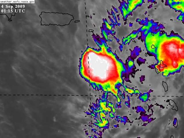
Convergence is still fairly high near Erika, expect the current blowup that Sanibel is conjuring to expand:
0 likes
-
SapphireSea
- Category 1

- Posts: 430
- Joined: Wed Aug 24, 2005 12:13 pm
- Location: Miami, FL
Re: ATL : TROPICAL DEPRESSION ERIKA (06L)
wxman57 wrote:Hard to tell, but I think the weak LLC is gone now. Convection around the MLC is weakening. NHC may call it dissipated in the next hour.
I see that as well. I think the MLC is going to collapse shortly too, if anything those last two blowups of covection may actually kill any weak centers when they collapse with the outflow I think. If those new bursts actually expand over the MLC maybe there is a chance, but its slim..
Would this be a sound observation?
0 likes

Re: ATL : TROPICAL DEPRESSION ERIKA (06L)
Anybodys guess tonight. See if she has enough for another convective explosion. My money is on atleast one more strong sheared blowup tonight.
0 likes
Re: ATL : TROPICAL DEPRESSION ERIKA (06L)
If that last burst doesn't expand, which it doesn't look like it will do, it's toast.
0 likes


-
Dean4Storms
- S2K Supporter

- Posts: 6358
- Age: 63
- Joined: Sun Aug 31, 2003 1:01 pm
- Location: Miramar Bch. FL

Re: ATL : TROPICAL DEPRESSION ERIKA (06L)
I decided to learn a bit about tropical systems, this season, so I've been lurking like an owl in a
tree for a week or so watching your posts, going to the image loops to try and see what each
was pointing out, and just watching the conversation flow. I admit, we've got a great gang
of pro mets and very good amateurs on here - I'm impressed! You all taught me quite a bit
while watching Danny go from exciting to "poor naked Danny", lol, and then watching Erika
fire up and then fade. Thanks to all of you for sharing your knowledge. I plan to lurk again in
the future. And, I'm glad all of our peeps in the Islands fared well with this storm. Thumbs up
to you all!
0 likes
-
gatorcane

- S2K Supporter
- Posts: 23708
- Age: 48
- Joined: Sun Mar 13, 2005 3:54 pm
- Location: Boca Raton, FL
Here the latest look at the models. You see the BAMs and CMC move it west as a weak system and the other models develop it and take it poleward pretty quickly.
Right now there are several good models that still want to develop this in a few days and take it northward off the Eastern seaboard of the US. That includes the GFDL, HWRF, GFS and NOGAPS.
What these models see is better upper-level winds to the north of the Caribbean with a nice upper-level anticyclone anchored offshore the SE US. If Erika or the remnant low get into that area, I think we'll see some redevelopment.
0 likes
-
expat2carib

- S2K Supporter
- Posts: 458
- Joined: Tue Jul 22, 2008 1:44 pm
- Location: Sint Maarten
Re: ATL : TROPICAL DEPRESSION ERIKA (06L)
The MLC and LLC didn't swing together for her. Mid level shear one of the factors.
She did get rid of the LLC can she ground herself? Can she keep her clothes on?
She did get rid of the LLC can she ground herself? Can she keep her clothes on?
0 likes
-
hurricanetrack

- HurricaneTrack.com
- Posts: 1781
- Joined: Tue Dec 02, 2003 10:46 pm
- Location: Wilmington, NC
- Contact:
This has to be one of the most painful storms to watch in a long, long time. Only Debby in 2000 comes close in my mind to something like this- that had so much potential but fell so short. Oh well, excellent news for anyone with coastal interests where ever this might have impacted.
I have to hand it to people like Bastardi who said the season would be defined by sinking air and storms struggling to get going- but this is bad, really bad but hey, he said the Euro showed this happening months ago. Wow. Go figure.
I have to hand it to people like Bastardi who said the season would be defined by sinking air and storms struggling to get going- but this is bad, really bad but hey, he said the Euro showed this happening months ago. Wow. Go figure.
0 likes
-
gatorcane
- S2K Supporter
- Posts: 23708
- Age: 48
- Joined: Sun Mar 13, 2005 3:54 pm
- Location: Boca Raton, FL
The only chance she has is to move northwards north of the islands and take advantage of a nice anti-cyclone anchored off the SE US mainland. The upper-level winds are favorable there and would allow development. Indeed several models think she will redevelop there in a few days and head northward likely away from the United States. This would happen towards the end of this weekend and into early next week if it does.
Note the anticyclone:

Note the anticyclone:
0 likes
-
Gustywind

- Category 5
- Posts: 12334
- Joined: Mon Sep 03, 2007 7:29 am
- Location: Baie-Mahault, GUADELOUPE
Final measurements concerning the amounts of water in Guadeloupe...during the last 24 Hours
Erika's episode
Meteo-France Guadeloupe measured 100 millimeters at Basse-Terre and higher in some areas in vicinity. 150 millimeters have been reported on the east of Guadeloupe ("Grande Terre"). Another area in Grande Terre, Le Moule experienced 80 and Petit-Canal 75.
Les Saintes have 96 millimeters and la Désirade 77.
Strongests gusts have reached 90 kilometer per hour (49kts) at Marie-Galante.
To sum up weak TS effects, but for sure Basse-Terre experienced this" little "feature as HUC said ("yeah I FELT IT yesterday night") in one of it previous posts about the violents thunder impacts abating, frequents lightnings, juicy amount of rain showers). Basse-Terre and the adjacents areas have reported very very minor damages even nothing in spite of two big floodings (Trois-Rivières and Bouillante) given the latest infos from the radio and TV.
Gustywind
0 likes
Re: ATL : TROPICAL DEPRESSION ERIKA (06L)
You can really see the mid circulation dissipating back by the QuickScat center showing this storm was screwed up in structure. Meanwhile that weak surface vortex from which the last burst is eminating is sputtering in unfavorable air and shear. Bottom line is toast like Ana.
2009 storms need a head start to break this barrier of negative conditions.
2009 storms need a head start to break this barrier of negative conditions.
0 likes
-
BensonTCwatcher

- Category 5
- Posts: 1050
- Joined: Sat Aug 28, 2004 10:11 pm
- Location: Southport NC
-
hurricanetrack
- HurricaneTrack.com
- Posts: 1781
- Joined: Tue Dec 02, 2003 10:46 pm
- Location: Wilmington, NC
- Contact:
Re: ATL : TROPICAL DEPRESSION ERIKA (06L)
This Nino year has produced a July like shear condition in the Caribbean in prime September.
0 likes
-
lonelymike
- S2K Supporter
- Posts: 634
- Joined: Sat Jul 26, 2008 10:12 am
- Location: walton county fla
Re:
I have to hand it to people like Bastardi who said the season would be defined by sinking air and storms struggling to get going- but this is bad, really bad but hey, he said the Euro showed this happening months ago. Wow. Go figure.[/quote]
What.....praise for the Euro and Joe B in the same post? Ye must be taught never to do that again. Don't you know that the GFS and Bob Breck are the only approved model and procnosticator allowed on this board. Next time ye shall be flogged with a banana peel and a Michael Jackson video.
What.....praise for the Euro and Joe B in the same post?
0 likes
-
deltadog03

- Professional-Met

- Posts: 3580
- Joined: Tue Jul 05, 2005 6:16 pm
- Location: Macon, GA
As far as I am concerned Erika is DEAD. She might have a pretty healthy MLC, but we don't name systems for mlc's. So, its adios IMO for erika. Now, her remains **could** have a future if the crap would move north of the islands. Mid shear is pretty much nada up there, but the crap isn't moving much. rant over....I am tired of the tropics this year...bring me winter!!! 
0 likes
-
lonelymike
- S2K Supporter
- Posts: 634
- Joined: Sat Jul 26, 2008 10:12 am
- Location: walton county fla
Re: ATL : TROPICAL DEPRESSION ERIKA (06L)
Sanibel wrote:This Nino year has produced a July like shear condition in the Caribbean in prime September.
Isn't that amazing. Also the Gulf has a fair amount of shear for this time of year. That's what makes weather so fascinating.
0 likes
Who is online
Users browsing this forum: No registered users and 96 guests