ATL: TROPICAL LOW ex-FRED (ex-07L)
Moderator: S2k Moderators

Re: ATL: HURRICANE FRED (07L)
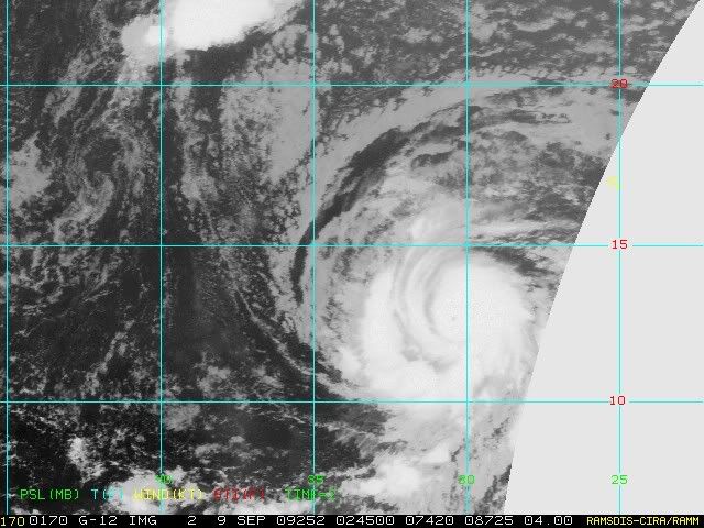
Hurricanes with a small eye tend to intensify rapidily, let's see if Fred is one of them.
0 likes
-
pepeavilenho
- Tropical Storm

- Posts: 171
- Joined: Thu Jul 09, 2009 12:01 pm
Re:
[quote="HURAKAN'']I think Fred has a good shot at becoming a major hurricane before the shear begins to have a significant impact[/quote]
are you serious!!!
wuau
Time Lat Lon Wind(mph) Pressure Storm type
------------------------------------------------------------------------
21 GMT 09/07/09 12.5N 24.5W 35 1005 Tropical Depression
03 GMT 09/08/09 11.8N 26.3W 40 1004 Tropical Storm
09 GMT 09/08/09 11.8N 27.3W 50 1000 Tropical Storm
15 GMT 09/08/09 11.9N 28.6W 65 994 Tropical Storm
21 GMT 09/08/09 12.1N 29.8W 70 990 Tropical Storm
03 GMT 09/09/09 12.6N 30.6W 75 987 Category 1 Hurricane


bye!!
i go sleep, here it's 5:03 a.m.
are you serious!!!
wuau
Time Lat Lon Wind(mph) Pressure Storm type
------------------------------------------------------------------------
21 GMT 09/07/09 12.5N 24.5W 35 1005 Tropical Depression
03 GMT 09/08/09 11.8N 26.3W 40 1004 Tropical Storm
09 GMT 09/08/09 11.8N 27.3W 50 1000 Tropical Storm
15 GMT 09/08/09 11.9N 28.6W 65 994 Tropical Storm
21 GMT 09/08/09 12.1N 29.8W 70 990 Tropical Storm
03 GMT 09/09/09 12.6N 30.6W 75 987 Category 1 Hurricane
bye!!
i go sleep, here it's 5:03 a.m.
0 likes

Re: ATL: HURRICANE FRED (07L)
Hurricanes with small eyes do intensify rapidly. Remember Gilbert or Wilma? I think Fred could become a major hurricane.
0 likes
Re: ATL: HURRICANE FRED (07L)
Ptarmigan wrote:Hurricanes with small eyes do intensify rapidly. Remember Gilbert or Wilma? I think Fred could become a major hurricane.
And more recently Jimena, though it was on the EPAC
0 likes
-
brunota2003

- S2K Supporter

- Posts: 9476
- Age: 35
- Joined: Sat Jul 30, 2005 9:56 pm
- Location: Stanton, KY...formerly Havelock, NC
- Contact:
Re: ATL: HURRICANE FRED (07L)
Macrocane wrote:
And more recently Jimena, though it was on the EPAC
Any storms with small eye will intensify quickly.
0 likes
-
cycloneye

- Admin

- Posts: 149214
- Age: 69
- Joined: Thu Oct 10, 2002 10:54 am
- Location: San Juan, Puerto Rico
Re: ATL: HURRICANE FRED (07L) - Computer Models
I am really puzzled by what the BAM model shows. 
0 likes
-
brunota2003
- S2K Supporter
- Posts: 9476
- Age: 35
- Joined: Sat Jul 30, 2005 9:56 pm
- Location: Stanton, KY...formerly Havelock, NC
- Contact:
If I am not mistaken, when the three BAMs run together, the winds are more favorable...but the more spread between the models, the greater the wind shear...in this case, the BAMD and BAMM both turn towards the north towards the weakness, while the shallow BAMS has the shallow steering currents turning in the completely opposite direction, south...meaning when it gets to the point of the split, it will begin encountering increasing shear, if I remember correctly?
0 likes
-
ncweatherwizard
- Professional-Met

- Posts: 1243
- Joined: Wed Sep 03, 2003 9:45 am
- Location: Ft. Collins, CO
Re: ATL: HURRICANE FRED (07L)
Ptarmigan wrote:Macrocane wrote:
And more recently Jimena, though it was on the EPAC
Any storms with small eye will intensify quickly.
Not necessarily. Some very powerful hurricanes have large eyes as well. While it is true that hurricanes with small eyes and very tight banding patterns around that eye are often intense hurricanes, many tropical storms and weak hurricanes in their formative stages show small eyes without very intense banding or an extreme pressure gradient.
0 likes


-
bob rulz
- Category 5

- Posts: 1711
- Age: 35
- Joined: Sat Jan 28, 2006 7:30 pm
- Location: Salt Lake City, Utah
Re: ATL: HURRICANE FRED (07L)
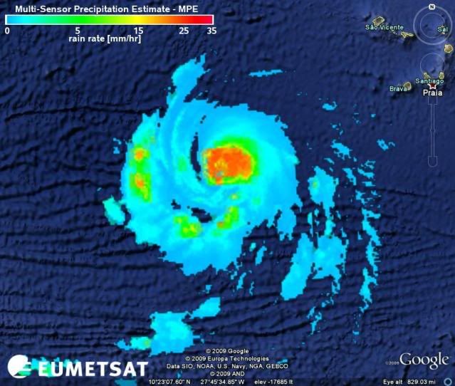
Fred is looking very good and continues to show steady improvement...the eye is quite clear and has a beautiful structure.
Category 2 at 5am looks very possible...
Category 2 at 5am looks very possible...
0 likes
-
Hurricane Cheese

- Category 1

- Posts: 365
- Joined: Thu Aug 12, 2004 12:40 am
- Location: Green Bay, WI (UWGB Earth Science Alum)
Re: ATL: HURRICANE FRED (07L) - Computer Models
Fred is smelling Fishy...on to the next wave!
0 likes
-
HurricaneHunter914
- Category 5
- Posts: 4439
- Age: 32
- Joined: Fri Mar 10, 2006 7:36 pm
- Location: College Station, TX

-
HURAKAN

- Professional-Met
- Posts: 46084
- Age: 39
- Joined: Thu May 20, 2004 4:34 pm
- Location: Key West, FL
- Contact:
Re:
HURAKAN wrote:I think Fred has a good shot at becoming a major hurricane before the shear begins to have a significant impact
That small eye was all I needed to make the statement
0 likes
Who is online
Users browsing this forum: No registered users and 21 guests