A few low-water crossings flooded around the city but for the most part ... just welcomed rain.
C/S TX Weather: Seasonal with some rains
Moderator: S2k Moderators
Forum rules

The posts in this forum are NOT official forecast and should not be used as such. They are just the opinion of the poster and may or may not be backed by sound meteorological data. They are NOT endorsed by any professional institution or STORM2K.
-
Portastorm

- Storm2k Moderator

- Posts: 9954
- Age: 63
- Joined: Fri Jul 11, 2003 9:16 am
- Location: Round Rock, TX
- Contact:
Re: C/SC TX Weather #1: Wet week ahead?
Happy days ... received about 2.25 inches since midnight in SW Austin! 
A few low-water crossings flooded around the city but for the most part ... just welcomed rain.
A few low-water crossings flooded around the city but for the most part ... just welcomed rain.
0 likes
-
somethingfunny

- ChatStaff

- Posts: 3926
- Age: 37
- Joined: Thu May 31, 2007 10:30 pm
- Location: McKinney, Texas
Re: C/SC TX Weather #1: Wet week ahead?
Reporting from the northern frontier (Dallas)....
Just wanted to let you guys know that this cold front means business. We haven't gotten out of the 60s today! Enjoy it while it lasts!
Just wanted to let you guys know that this cold front means business. We haven't gotten out of the 60s today! Enjoy it while it lasts!
0 likes

Re: C/SC TX Weather #1: Wet week ahead?
It's really chilly out!
Don't know how much rain we've gotten - I forgot to put the gauge back out last night after the yard got mowed....
Don't know how much rain we've gotten - I forgot to put the gauge back out last night after the yard got mowed....
0 likes
-
Portastorm
- Storm2k Moderator
- Posts: 9954
- Age: 63
- Joined: Fri Jul 11, 2003 9:16 am
- Location: Round Rock, TX
- Contact:
Re: C/SC TX Weather #1: variable week ahead
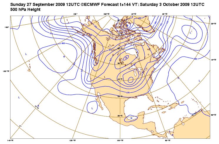
Interesting snippet below from this afternoon's AFD out of NWS New Braunfels. I have seen those Euro runs and the mets are kidding ... next weekend could be quite a wet one for us in central and south Texas!
*****
LOOKING INTO LATE NEXT WEEKEND...A MORE WIDESPREAD RAIN
EVENT COULD UNFOLD. THE ECMWF SHOWED EXCELLENT RUN-TO-RUN
CONSISTENCY FROM THE 12Z CYCLE YESTERDAY TO 00Z TODAY...TO 12Z
THIS MORNING SHOWING A TROPICAL CYCLONE DEVELOPING IN THE EASTERN
PACIFIC LATE WEDNESDAY OR THURSDAY. THE ECMWF SOLUTION SHOWS THIS
CYCLONE GETTING PICKED-UP BY A DEVELOPING WEST COAST TROUGH LATE
FRIDAY INTO SATURDAY...THEN MOVING ACROSS MEXICO ON SUNDAY TOWARD
OUR AREA. THE GFS SOLUTION HAS TRENDED CLOSER TO THE ECMWF...BUT
IS LATER IN THE TIMING. FOR NOW...WILL GO WITH 30 POPS ALONG THE
I-35 CORRIDOR FOR NEXT SUNDAY...WHICH IS ABOVE CLIMO AND
RELATIVELY HIGH FOR A DAY 7 FORECAST.
0 likes
-
srainhoutx

- S2K Supporter

- Posts: 6919
- Age: 68
- Joined: Sun Jan 14, 2007 11:34 am
- Location: Haywood County, NC
- Contact:
Re: C/SC TX Weather #1: variable week ahead
Portastorm wrote:Interesting snippet below from this afternoon's AFD out of NWS New Braunfels. I have seen those Euro runs and the mets are kidding ... next weekend could be quite a wet one for us in central and south Texas!
*****
LOOKING INTO LATE NEXT WEEKEND...A MORE WIDESPREAD RAIN
EVENT COULD UNFOLD. THE ECMWF SHOWED EXCELLENT RUN-TO-RUN
CONSISTENCY FROM THE 12Z CYCLE YESTERDAY TO 00Z TODAY...TO 12Z
THIS MORNING SHOWING A TROPICAL CYCLONE DEVELOPING IN THE EASTERN
PACIFIC LATE WEDNESDAY OR THURSDAY. THE ECMWF SOLUTION SHOWS THIS
CYCLONE GETTING PICKED-UP BY A DEVELOPING WEST COAST TROUGH LATE
FRIDAY INTO SATURDAY...THEN MOVING ACROSS MEXICO ON SUNDAY TOWARD
OUR AREA. THE GFS SOLUTION HAS TRENDED CLOSER TO THE ECMWF...BUT
IS LATER IN THE TIMING. FOR NOW...WILL GO WITH 30 POPS ALONG THE
I-35 CORRIDOR FOR NEXT SUNDAY...WHICH IS ABOVE CLIMO AND
RELATIVELY HIGH FOR A DAY 7 FORECAST.
Actually Port, all the TX WFO's are talking about this EPAC system already. We shall see.
0 likes
-
srainhoutx
- S2K Supporter
- Posts: 6919
- Age: 68
- Joined: Sun Jan 14, 2007 11:34 am
- Location: Haywood County, NC
- Contact:
Re: C/SC TX Weather #1: variable week ahead
FLOOD ADVISORY
NATIONAL WEATHER SERVICE AUSTIN/SAN ANTONIO TX
442 PM CDT MON SEP 28 2009
TXC053-299-282345-
/O.NEW.KEWX.FA.Y.0107.090928T2142Z-090928T2345Z/
/00000.N.ER.000000T0000Z.000000T0000Z.000000T0000Z.OO/
442 PM CDT MON SEP 28 2009
THE NATIONAL WEATHER SERVICE IN AUSTIN SAN ANTONIO HAS ISSUED A
* SMALL STREAM FLOOD ADVISORY FOR...
CENTRAL BURNET COUNTY...
LLANO COUNTY...
* UNTIL 645 PM CDT.
* AT 438 PM CDT SLOW MOVING SHOWERS AND THUNDERSTORMS FROM NEAR
CASTELL TO LLANO TO LAKE BUCHANAN AND BURNET WILL PRODUCE LOCALLY
HEAVY RAINFALL AMOUNTS BETWEEN ONE AND TWO INCHES.
0 likes
Re: C/SC TX Weather #1: variable week ahead
2.5" of rain overnight!
The weeds are exceedingly happy!
The weeds are exceedingly happy!
0 likes
-
Portastorm
- Storm2k Moderator
- Posts: 9954
- Age: 63
- Joined: Fri Jul 11, 2003 9:16 am
- Location: Round Rock, TX
- Contact:
Re: C/SC TX Weather #1: variable week ahead
Wow, nice! We didn't get nearly that much in SW Austin ... most of ours came this morning. I'd say about a quarter-inch fell this morning, of course right during the time the kids were going to school. But hey, I'm not complaining. Let it rain!
0 likes
Re: C/SC TX Weather #1: variable week ahead
Ours was all before 7am. We had some seriously close lightning strikes - the kind where you see the flash and hear/feel the boom at the same time. Never lost power tho.
0 likes
-
srainhoutx
- S2K Supporter
- Posts: 6919
- Age: 68
- Joined: Sun Jan 14, 2007 11:34 am
- Location: Haywood County, NC
- Contact:
Re: C/SC TX Weather #1: variable week ahead
Interesting Update from EWX this morning. They seem to be a bit bullish on the EPAC system. We shall see...
AREA FORECAST DISCUSSION
NATIONAL WEATHER SERVICE AUSTIN/SAN ANTONIO TX
1055 AM CDT WED SEP 30 2009
.UPDATE...
WEAKENING FRONTAL ZONE SOUTH AND WEST OF SAN ANTONIO RESULTED IN
SCATTERED LIGHT RAIN SHOWERS EARLY THIS MORNING. THIS AREA HAS DEW
POINTS RUNNING IN THE LOW TO MID 70S AND IS EXPECTED TO TRANSLATE
EASTWARD DURING THE DAY. A BRIEF AND WEAK THUNDERSTORM WILL BE
POSSIBLE IN THIS AREA WHERE INSOLATION WILL BE BEST. THE UPPER
RIDGE WILL OTHERWISE PRECLUDE CONVECTION WITH ABUNDANT CLOUDS
LIKELY TO HOLD TEMPS OVER OUR NORTHERN COUNTIES A FEW DEGREES
COOLER THAN PREVIOUSLY PROJECTED. AS THE FRONTAL ZONE CONTINUES TO
WASH OUT, THE EVENING WEATHER SHOULD BE QUIET; HOWEVER, DEEP LOW
LEVEL MOISTURE AND INCREASING ENERGY ALOFT COMING IN FROM THE WEST
COULD SUPPORT ISOLATED SHOWERS AFTER MIDNIGHT. THE PROGRESSIVE
RIDGE ALOFT SHOULD TRANSLATE EAST WITH THE BASE OF A PROGRESSIVE
NORTHERN PLAINS TROUGH BEGINNING TO ENHANCE RAIN POTENTIAL FOR
THURSDAY. A BROAD AREA OF DEVELOPING TROPICAL ACTIVITY WEST OF
MEXICO SHOULD ENHANCE THIS RAIN POTENTIAL BY INCREASING PACIFIC
MOISTURE INTO AN AREA THAT WOULD NORMALLY BE A DRY SLOT REGION.
THE TROPICAL PATTERN WILL NEED TO BE MONITORED CLOSELY FOR LATER
PERIODS, SINCE A FRONTAL ZONE SETTING UP THIS WEEKEND COULD MAKE
FOR A CLASSIC OCTOBER HEAVY RAIN PATTERN. MANY UNCERTAINTIES
REMAIN, WITH THE DEVELOPMENT OF THE TROPICAL SYSTEM AND THE
STRENGTH, DEPTH AND LOCATION OF THE FRONTAL ZONE.
0 likes
Carla/Alicia/Jerry(In The Eye)/Michelle/Charley/Ivan/Dennis/Katrina/Rita/Wilma/Ike/Harvey
Member: National Weather Association
Wx Infinity Forums
http://wxinfinity.com/index.php
Facebook.com/WeatherInfinity
Twitter @WeatherInfinity
Member: National Weather Association
Wx Infinity Forums
http://wxinfinity.com/index.php
Facebook.com/WeatherInfinity
Twitter @WeatherInfinity
-
Portastorm
- Storm2k Moderator
- Posts: 9954
- Age: 63
- Joined: Fri Jul 11, 2003 9:16 am
- Location: Round Rock, TX
- Contact:
Re: C/SC TX Weather #1: variable week ahead
Caught my eye as well this morning when I saw that.
The Euro, as you know, has been fairly consistent the last few days in bringing a tremendous amount of Pacific moisture across Mexico and into Texas by Monday.
And I don't need to tell you Houston folks about what stalled frontal boundaries with tropical moisture from the Pacific can do in October!
The Euro, as you know, has been fairly consistent the last few days in bringing a tremendous amount of Pacific moisture across Mexico and into Texas by Monday.
And I don't need to tell you Houston folks about what stalled frontal boundaries with tropical moisture from the Pacific can do in October!
0 likes
-
srainhoutx
- S2K Supporter
- Posts: 6919
- Age: 68
- Joined: Sun Jan 14, 2007 11:34 am
- Location: Haywood County, NC
- Contact:
Re: C/SC TX Weather #1: variable week ahead
0 likes
Carla/Alicia/Jerry(In The Eye)/Michelle/Charley/Ivan/Dennis/Katrina/Rita/Wilma/Ike/Harvey
Member: National Weather Association
Wx Infinity Forums
http://wxinfinity.com/index.php
Facebook.com/WeatherInfinity
Twitter @WeatherInfinity
Member: National Weather Association
Wx Infinity Forums
http://wxinfinity.com/index.php
Facebook.com/WeatherInfinity
Twitter @WeatherInfinity
-
somethingfunny
- ChatStaff
- Posts: 3926
- Age: 37
- Joined: Thu May 31, 2007 10:30 pm
- Location: McKinney, Texas
-
Portastorm
- Storm2k Moderator
- Posts: 9954
- Age: 63
- Joined: Fri Jul 11, 2003 9:16 am
- Location: Round Rock, TX
- Contact:
Re:
somethingfunny wrote:Are the models all basing their rainfall predictions off an assumption that 91E will develop into something larger, or does it even matter when we're discussing moisture content?
Here's a link to today's 12z Euro. See for yourself. Looks like 91E is developed to some extent but I cannot tell if the Euro thinks it'll be a full fledged system or not.
http://www.meteo.psu.edu/~gadomski/ECMWF_12z/ecmwfloop.html
The last 0z and 12z GFS runs, btw, show similar scenarios.
0 likes
-
srainhoutx
- S2K Supporter
- Posts: 6919
- Age: 68
- Joined: Sun Jan 14, 2007 11:34 am
- Location: Haywood County, NC
- Contact:
Re: C/SC TX Weather #1: variable week ahead
I think it's more related to moisture inflow from the disturbance, rather than development ATT. 91 E has really never been forecast to be a "strong" system. With that said, the frontal boundry and it's location along with the mid and upper level flow from th SW will be the key.
From the 12Z QPF map from the HPC you can see some of what is being discussed.
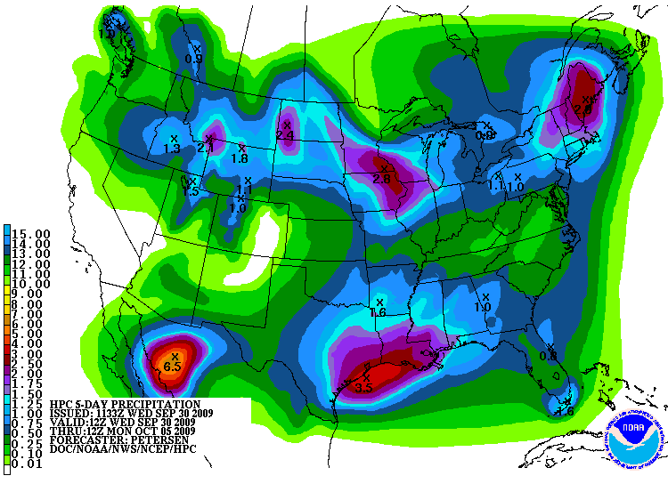
From the 12Z QPF map from the HPC you can see some of what is being discussed.
0 likes
Carla/Alicia/Jerry(In The Eye)/Michelle/Charley/Ivan/Dennis/Katrina/Rita/Wilma/Ike/Harvey
Member: National Weather Association
Wx Infinity Forums
http://wxinfinity.com/index.php
Facebook.com/WeatherInfinity
Twitter @WeatherInfinity
Member: National Weather Association
Wx Infinity Forums
http://wxinfinity.com/index.php
Facebook.com/WeatherInfinity
Twitter @WeatherInfinity
-
srainhoutx
- S2K Supporter
- Posts: 6919
- Age: 68
- Joined: Sun Jan 14, 2007 11:34 am
- Location: Haywood County, NC
- Contact:
Re: C/SC TX Weather #1: variable week ahead
Hmmm...
SPECIAL WEATHER STATEMENT
NATIONAL WEATHER SERVICE AUSTIN/SAN ANTONIO TX
355 PM CDT WED SEP 30 2009
TXZ171>173-183>194-202>209-217>225-228-010900-
LLANO-BURNET-WILLIAMSON-VAL VERDE-EDWARDS-REAL-KERR-BANDERA-
GILLESPIE-KENDALL-BLANCO-HAYS-TRAVIS-BASTROP-LEE-KINNEY-UVALDE-
MEDINA-BEXAR-COMAL-GUADALUPE-CALDWELL-FAYETTE-MAVERICK-ZAVALA-
FRIO-ATASCOSA-WILSON-KARNES-GONZALES-DE WITT-LAVACA-DIMMIT-
INCLUDING THE CITIES OF...LLANO...BURNET...GEORGETOWN...DEL RIO...
ROCKSPRINGS...LEAKEY...KERRVILLE...BANDERA...FREDERICKSBURG...
BOERNE...BLANCO...SAN MARCOS...AUSTIN...BASTROP...GIDDINGS...
BRACKETTVILLE...UVALDE...HONDO...SAN ANTONIO...NEW BRAUNFELS...
SEGUIN...LOCKHART...LA GRANGE...EAGLE PASS...CRYSTAL CITY...
PEARSALL...PLEASANTON...FLORESVILLE...KARNES CITY...GONZALES...
CUERO...HALLETTSVILLE...CARRIZO SPRINGS
355 PM CDT WED SEP 30 2009
...HEAVY RAINFALL POSSIBLE THIS WEEKEND...
ABUNDANT TROPICAL MOISTURE AND AN OVERRUNNING PATTERN IS EXPECTED
TO PRODUCE FAVORABLE CONDITIONS FOR HEAVY RAINFALL OVER THE
WEEKEND. SOUTHWEST WINDS ALOFT WILL TRANSPORT MOISTURE FROM A
DEVELOPING TROPICAL DISTURBANCE OVER THE EASTERN PACIFIC TONIGHT
THROUGH THIS WEEKEND. A COLD FRONT IS EXPECTED TO SETTLE OVER
SOUTH TEXAS EARLY FRIDAY...PROVIDING A FOCUS FOR SCATTERED TO
NUMEROUS SHOWERS AND THUNDERSTORMS THIS WEEKEND.
RAIN CHANCES ARE EXPECTED TO INCREASE RAPIDLY BY SATURDAY
MORNING...WITH THE HIGHEST POTENTIAL FOR HEAVY RAINFALL EXPECTED
TO DEVELOP SATURDAY NIGHT INTO SUNDAY. THIS TYPE OF HEAVY RAINFALL
PATTERN WILL BE CAPABLE OF PRODUCING WIDESPREAD HEAVY RAINS OF 2
TO 5 INCHES...WITH ISOLATED TOTALS OVER 10 INCHES.
THOSE WITH WEEKEND PLANS SHOULD MONITOR THE WEATHER CLOSELY...AND
PLAN AHEAD FOR POTENTIAL FLASH FLOODING.
0 likes
Carla/Alicia/Jerry(In The Eye)/Michelle/Charley/Ivan/Dennis/Katrina/Rita/Wilma/Ike/Harvey
Member: National Weather Association
Wx Infinity Forums
http://wxinfinity.com/index.php
Facebook.com/WeatherInfinity
Twitter @WeatherInfinity
Member: National Weather Association
Wx Infinity Forums
http://wxinfinity.com/index.php
Facebook.com/WeatherInfinity
Twitter @WeatherInfinity
-
Portastorm
- Storm2k Moderator
- Posts: 9954
- Age: 63
- Joined: Fri Jul 11, 2003 9:16 am
- Location: Round Rock, TX
- Contact:
Re: C/SC TX Weather #1: variable week ahead
In their afternoon AFD, NWS New Braunfels talks more specifically about the potential heavy rain threat. They do point out that it is possible that the tropical moisture shears out more quickly than what the models are progging ... in which case the rain totals, while welcomed, would not be nearly as substantial. We shall see.
Thousands of folks coming to Austin this weekend for the Austin City Limits music festival. This ought to be interesting!
Thousands of folks coming to Austin this weekend for the Austin City Limits music festival. This ought to be interesting!
0 likes
-
Portastorm
- Storm2k Moderator
- Posts: 9954
- Age: 63
- Joined: Fri Jul 11, 2003 9:16 am
- Location: Round Rock, TX
- Contact:
Re: C/SC TX Weather #1: variable week ahead
Looks like we may have some severe weather on tap later today/this evening.
http://www.spc.noaa.gov/products/md/md2053.html
http://www.spc.noaa.gov/products/md/md2053.html
0 likes
-
lrak

- S2K Supporter
- Posts: 1770
- Age: 59
- Joined: Thu Jun 21, 2007 2:48 pm
- Location: Corpus Christi, TX
Re: C/SC TX Weather #1: wet, stormy weekend ahead
Portastorm wrote:Looks like more rain on the way with a persistant shear zone overahead. Interesting to note that here in Austin, we're 8.82 inches above normal rainfall for the year. Also interesting to note that every year the Spurs have won the NBA title, a hurricane has hit Texas!
Maybe the remnants of a pacific storm will help the Spurs, this upcoming weekend sure looks wet for TX.
http://www.ssd.noaa.gov/goes/west/tpac/loop-wv.html
Seems like Olaf is going more north than the forecast.
0 likes
AKA karl
Also
Personal Forecast Disclaimer:
My posts on this forum are NOT official forecast and should not be used as such. My posts are my basic observations and are definitely not backed by any "well some" meteorological knowledge. For official information, please refer to the NHC and NWS products.
Also
Personal Forecast Disclaimer:
My posts on this forum are NOT official forecast and should not be used as such. My posts are my basic observations and are definitely not backed by any "well some" meteorological knowledge. For official information, please refer to the NHC and NWS products.
-
srainhoutx
- S2K Supporter
- Posts: 6919
- Age: 68
- Joined: Sun Jan 14, 2007 11:34 am
- Location: Haywood County, NC
- Contact:
Re: C/SC TX Weather #1: wet, stormy weekend ahead
PRELIMINARY LOCAL STORM REPORT
NATIONAL WEATHER SERVICE AUSTIN/SAN ANTONIO TX
844 PM CDT THU OCT 01 2009
..TIME.. ...EVENT... ...CITY LOCATION... ...LAT.LON...
..DATE.. ....MAG.... ..COUNTY LOCATION.. ST.. ...SOURCE....
..REMARKS..
0840 PM TSTM WND GST FLORENCE 30.84N 97.79W
10/01/2009 M80 MPH WILLIAMSON TX AMATEUR RADIO
SOME DAMAGE REPORTED. EXTENT UNKNOWN
0 likes
Carla/Alicia/Jerry(In The Eye)/Michelle/Charley/Ivan/Dennis/Katrina/Rita/Wilma/Ike/Harvey
Member: National Weather Association
Wx Infinity Forums
http://wxinfinity.com/index.php
Facebook.com/WeatherInfinity
Twitter @WeatherInfinity
Member: National Weather Association
Wx Infinity Forums
http://wxinfinity.com/index.php
Facebook.com/WeatherInfinity
Twitter @WeatherInfinity
Return to “USA & Caribbean Weather”
Who is online
Users browsing this forum: Stratton23, wxman22 and 42 guests