
613
WHXX01 KWBC 061928
CHGHUR
TROPICAL CYCLONE GUIDANCE MESSAGE
NWS TPC/NATIONAL HURRICANE CENTER MIAMI FL
1928 UTC TUE OCT 6 2009
DISCLAIMER...NUMERICAL MODELS ARE SUBJECT TO LARGE ERRORS.
PLEASE REFER TO NHC OFFICIAL FORECASTS FOR TROPICAL CYCLONE
AND SUBTROPICAL CYCLONE INFORMATION.
ATLANTIC OBJECTIVE AIDS FOR
DISTURBANCE HENRI (AL102009) 20091006 1800 UTC
...00 HRS... ...12 HRS... ...24 HRS. .. ...36 HRS...
091006 1800 091007 0600 091007 1800 091008 0600
LAT LON LAT LON LAT LON LAT LON
BAMS 17.7N 53.4W 19.1N 56.4W 20.4N 59.0W 21.3N 60.7W
BAMD 17.7N 53.4W 19.3N 55.0W 20.8N 56.3W 21.9N 57.2W
BAMM 17.7N 53.4W 18.9N 55.6W 20.1N 57.3W 20.7N 59.0W
LBAR 17.7N 53.4W 19.5N 55.4W 21.6N 56.6W 23.5N 57.0W
SHIP 35KTS 37KTS 39KTS 39KTS
DSHP 35KTS 37KTS 39KTS 39KTS
...48 HRS... ...72 HRS... ...96 HRS. .. ..120 HRS...
091008 1800 091009 1800 091010 1800 091011 1800
LAT LON LAT LON LAT LON LAT LON
BAMS 22.1N 62.2W 22.1N 64.3W 20.8N 68.2W 20.1N 74.0W
BAMD 22.7N 57.7W 20.6N 58.0W 17.9N 61.8W 16.8N 66.2W
BAMM 21.4N 60.5W 20.6N 63.6W 19.1N 69.2W 18.2N 75.4W
LBAR 25.3N 55.5W 28.4N 46.8W 36.0N 43.3W 35.7N 39.6W
SHIP 36KTS 38KTS 48KTS 58KTS
DSHP 36KTS 38KTS 48KTS 41KTS
...INITIAL CONDITIONS...
LATCUR = 17.7N LONCUR = 53.4W DIRCUR = 300DEG SPDCUR = 17KT
LATM12 = 15.9N LONM12 = 50.5W DIRM12 = 301DEG SPDM12 = 20KT
LATM24 = 13.7N LONM24 = 46.5W
WNDCUR = 35KT RMAXWD = 45NM WNDM12 = 30KT
CENPRS = 1007MB OUTPRS = 1012MB OUTRAD = 120NM SDEPTH = M
RD34NE = 45NM RD34SE = 0NM RD34SW = 0NM RD34NW = 0NM
$$
NNNN
ATL: TROPICAL DEPRESSION HENRI (10L)
Moderator: S2k Moderators

Re: ATL : INVEST 91L update=Tropical Storm Henri at 5 PM
Aric Dunn wrote:Evil Jeremy wrote:2nd time in 48 hours we go from code yellow to special advisory code red to full advisories in 3 hours. Unbelievable. Completely amazing. Then again, when studying the tropics, one should never forget rule #1: Anything can happen.
who wrote the special advisory.. compared to who wrote the 2pm ?
That is a great question.
I know that this is science and therefore unpredictable, however when you read an outlook at 2 PM and it is less than 30% and within an hour or two the same agency decides it will name the system; that is odd.......

Last edited by fci on Tue Oct 06, 2009 3:22 pm, edited 1 time in total.
0 likes
-
wxman57

- Moderator-Pro Met

- Posts: 23175
- Age: 68
- Joined: Sat Jun 21, 2003 8:06 pm
- Location: Houston, TX (southwest)
Re:
Evil Jeremy wrote:What kind of track do you all think the NHC will churn out at 5? WSW bend at the end, or more of a turn to the north? Or will it even survive for 5 days?
I think there's a high probability it's back to a sheared, exposed system within 12-24 hours. However, by 48-72 hours it should slow down/stall, track slowly west for a bit then high pressure builds to its north, steering it SW-WSW. Possibly toward PR or the DR in 5 days. But there may not be much left to track by then.
0 likes
-
cycloneye

- Admin

- Posts: 149520
- Age: 69
- Joined: Thu Oct 10, 2002 10:54 am
- Location: San Juan, Puerto Rico
Re: ATL : INVEST 91L update=Tropical Storm Henri at 5 PM
57,you think that track by 72 may verifie? You know what part I am talking about.
0 likes
Visit the Caribbean-Central America Weather Thread where you can find at first post web cams,radars
and observations from Caribbean basin members Click Here
and observations from Caribbean basin members Click Here
-
jlauderdal
- S2K Supporter

- Posts: 7240
- Joined: Wed May 19, 2004 5:46 am
- Location: NE Fort Lauderdale
- Contact:
Re: ATL : INVEST 91L update=Tropical Storm Henri at 5 PM
wait, i thought the models didn't develop it, i guess the koala bear post last night did the trick, no more grizzlies, pandas and polar bears rest of the season except my avatar of course
0 likes

Re: Re:
wxman57 wrote:Evil Jeremy wrote:What kind of track do you all think the NHC will churn out at 5? WSW bend at the end, or more of a turn to the north? Or will it even survive for 5 days?
I think there's a high probability it's back to a sheared, exposed system within 12-24 hours. However, by 48-72 hours it should slow down/stall, track slowly west for a bit then high pressure builds to its north, steering it SW-WSW. Possibly toward PR or the DR in 5 days. But there may not be much left to track by then.
Hoping the latter, that there isn't much to track...I'll be housesitting the same house I was in when we all were sure Omar was headed exactly toward us...I think I'm not letting them leave the island again in October. Not that I'm superstitious or anything like that...
0 likes
-
dixiebreeze
- S2K Supporter
- Posts: 5140
- Joined: Wed Sep 03, 2003 5:07 pm
- Location: crystal river, fla.
Re: ATL : INVEST 91L update=Tropical Storm Henri at 5 PM
Surprised that no Recon is scheduled yet.
0 likes
-
Blown Away

- S2K Supporter
- Posts: 10253
- Joined: Wed May 26, 2004 6:17 am
Re: ATL : INVEST 91L update=Tropical Storm Henri at 5 PM
jlauderdal wrote:wait, i thought the models didn't develop it, i guess the koala bear post last night did the trick, no more grizzlies, pandas and polar bears rest of the season except my avatar of course

jlauderdal, you nailed it! This bear was PO'd and was demanding Henri show himself.
0 likes
Hurricane Eye Experience: David 79, Irene 99, Frances 04, Jeanne 04, Wilma 05… Hurricane Brush Experience: Andrew 92, Erin 95, Floyd 99, Matthew 16, Irma 17, Ian 22, Nicole 22…
-
wxman57
- Moderator-Pro Met
- Posts: 23175
- Age: 68
- Joined: Sat Jun 21, 2003 8:06 pm
- Location: Houston, TX (southwest)
Re: ATL : INVEST 91L update=Tropical Storm Henri at 5 PM
cycloneye wrote:57,you think that track by 72 may verify? You know what part I am talking about.
Not sure what track you mean, cycloneye.
0 likes
-
cycloneye
- Admin
- Posts: 149520
- Age: 69
- Joined: Thu Oct 10, 2002 10:54 am
- Location: San Juan, Puerto Rico
Re: ATL : INVEST 91L update=Tropical Storm Henri at 5 PM
wxman57 wrote:cycloneye wrote:57,you think that track by 72 may verify? You know what part I am talking about.
Not sure what track you mean, cycloneye.
WSW to SW.
0 likes
Visit the Caribbean-Central America Weather Thread where you can find at first post web cams,radars
and observations from Caribbean basin members Click Here
and observations from Caribbean basin members Click Here
-
IvanSurvivor
- Tropical Storm

- Posts: 152
- Joined: Wed Aug 20, 2008 12:12 am
- Location: Pensacola Florida (Warrington)
-
wxman57
- Moderator-Pro Met
- Posts: 23175
- Age: 68
- Joined: Sat Jun 21, 2003 8:06 pm
- Location: Houston, TX (southwest)
Re: ATL : INVEST 91L update=Tropical Storm Henri at 5 PM
cycloneye wrote:wxman57 wrote:cycloneye wrote:57,you think that track by 72 may verify? You know what part I am talking about.
Not sure what track you mean, cycloneye.
WSW to SW.
Yes, definitely a good possibility.
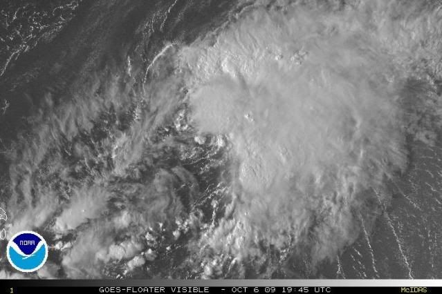
On another note, the convection that quickly built over the center a few hours ago is now being stripped away again by shear. This thing's going to be like most of the other storms in that region - sheared and exposed most of the time.
0 likes
-
Evil Jeremy

- S2K Supporter
- Posts: 5463
- Age: 32
- Joined: Mon Apr 10, 2006 2:10 pm
- Location: Los Angeles, CA
Re: ATL: Tropical Storm Henri - Models
ozone, we keep the threads once a system becomes an invest until it's death, regardless of classification in between.
0 likes
Frances 04 / Jeanne 04 / Katrina 05 / Wilma 05 / Fay 08 / Debby 12 / Andrea 13 / Colin 16 / Hermine 16 / Matthew 16 / Irma 17
-
PTrackerLA

- Category 5

- Posts: 5281
- Age: 42
- Joined: Thu Oct 10, 2002 8:40 pm
- Location: Lafayette, LA
-
ozonepete
- Professional-Met

- Posts: 4743
- Joined: Mon Sep 07, 2009 3:23 pm
- Location: From Ozone Park, NYC / Now in Brooklyn, NY
Re: ATL : INVEST 91L update=Tropical Storm Henri at 5 PM
wxman57 wrote:On another note, the convection that quickly built over the center a few hours ago is now being stripped away again by shear. This thing's going to be like most of the other storms in that region - sheared and exposed most of the time.
Huh? What? The latest burst is right over the center.
0 likes
-
Emmett_Brown

- Category 5
- Posts: 1433
- Joined: Wed Aug 24, 2005 9:10 pm
- Location: Sarasota FL
Re: ATL : INVEST 91L update=Tropical Storm Henri at 5 PM
ozonepete wrote:wxman57 wrote:On another note, the convection that quickly built over the center a few hours ago is now being stripped away again by shear. This thing's going to be like most of the other storms in that region - sheared and exposed most of the time.
Huh? What? The latest burst is right over the center.
But you can see the CDO starting to shift to the NE in the last frame or 2. Soon to be sheared off. However, interesting that the shear seems to be blowing more from the S/SW now, like it is backing.
0 likes
-
wxman57
- Moderator-Pro Met
- Posts: 23175
- Age: 68
- Joined: Sat Jun 21, 2003 8:06 pm
- Location: Houston, TX (southwest)
Re: ATL : INVEST 91L update=Tropical Storm Henri at 5 PM
ozonepete wrote:wxman57 wrote:On another note, the convection that quickly built over the center a few hours ago is now being stripped away again by shear. This thing's going to be like most of the other storms in that region - sheared and exposed most of the time.
Huh? What? The latest burst is right over the center.
http://i189.photobucket.com/albums/z174 ... 061945.jpg
I don't believe so. The center is moving WNW and the convection is fading of to the east.
0 likes
-
MGC

- S2K Supporter
- Posts: 5940
- Joined: Sun Mar 23, 2003 9:05 pm
- Location: Pass Christian MS, or what is left.
Re: ATL: Tropical Storm Henri
Henri is a tiny system. Will likely battle shear which should hold Henri down.......MGC
0 likes
Who is online
Users browsing this forum: No registered users and 18 guests