drdavisjr wrote:cycloneye wrote:Great interview Jim.
Where can I see this interview? Link?
He was just live on the Weather Channel.
Moderator: S2k Moderators
drdavisjr wrote:cycloneye wrote:Great interview Jim.
Where can I see this interview? Link?

ozonepete wrote:drdavisjr wrote:ozonepete or hurakan, how much difference does 20 or 30 miles make in a storm like this? We have friends in Laguna and Cavite (south of Manila) but we live in Quezon City (northeast of Manila). Would it be safer down south?
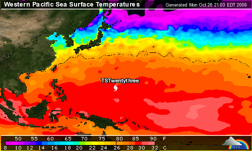
20 or 30 miles is usually insignificant if you both are in the same sector of the storm. That's a really small distance in terms of the coverage of a tropical cyclone. More important considerations are it is bad if the area is near the ocean, if the area floods easily and if it faces east. I would rather be facing west with a mountain behind me when this comes in. Otherwise, it won't make much difference.
Also, remember once again that the average track error is 300 miles at 3 days out, so at this point all we know is that it could pass completely north of Luzon or go into the southern Philippines. Way too early.

ozonepete wrote:drdavisjr wrote:ozonepete or hurakan, how much difference does 20 or 30 miles make in a storm like this? We have friends in Laguna and Cavite (south of Manila) but we live in Quezon City (northeast of Manila). Would it be safer down south?
20 or 30 miles is usually insignificant if you both are in the same sector of the storm. That's a really small distance in terms of the coverage of a tropical cyclone. More important considerations are it is bad if the area is near the ocean, if the area floods easily and if it faces east. I would rather be facing west with a mountain behind me when this comes in. Otherwise, it won't make much difference.
Also, remember once again that the average track error is 300 miles at 3 days out, so at this point all we know is that it could pass completely north of Luzon or go into the southern Philippines. Way too early.
JTE50 wrote:StormingB81 wrote:You feeling better Jim? Over that sickness yet?
I sleep for 5 hours and now I'm fine. I'm ready to go back to the Philippines!
Thanks for recording ! They tell me it's set for 10:10pm eastern

JTE50 wrote:[="quote="drdavisjr"]JTE50 wrote:StormingB81 wrote:You feeling better Jim? Over that sickness yet?
I sleep for 5 hours and now I'm fine. I'm ready to go back to the Philippines!
Thanks for recording ! They tell me it's set for 10:10pm eastern
LOL! Crazy storms! Back and forth...


drdavisjr wrote:ozonepete wrote:drdavisjr wrote:ozonepete or hurakan, how much difference does 20 or 30 miles make in a storm like this? We have friends in Laguna and Cavite (south of Manila) but we live in Quezon City (northeast of Manila). Would it be safer down south?
20 or 30 miles is usually insignificant if you both are in the same sector of the storm. That's a really small distance in terms of the coverage of a tropical cyclone. More important considerations are it is bad if the area is near the ocean, if the area floods easily and if it faces east. I would rather be facing west with a mountain behind me when this comes in. Otherwise, it won't make much difference.
Also, remember once again that the average track error is 300 miles at 3 days out, so at this point all we know is that it could pass completely north of Luzon or go into the southern Philippines. Way too early.
Thanks! We're facing a mountain here, so I think we'll stay put.
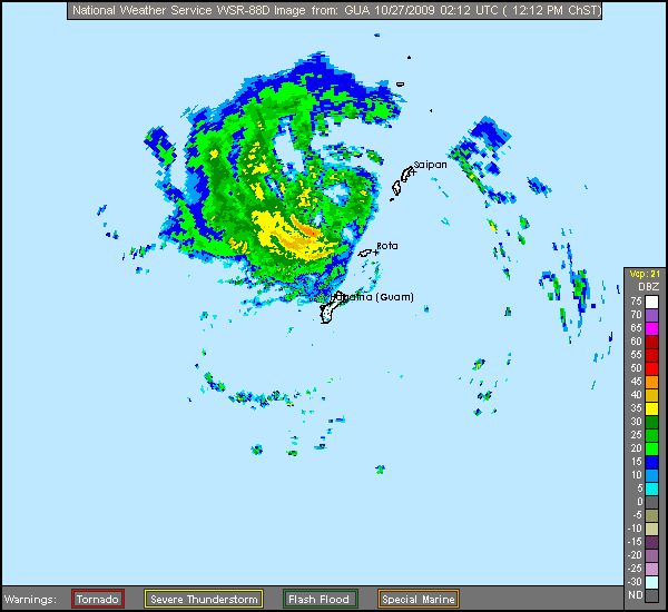
Look at the radar that Hurakan just posted. The center of circulation, or the developing eye, is becoming apparent northwest of Rota. It is not very well-defined - there are rain echoes on the left side of this "circle", but you have to look at it objectively and look for where the main circle of the clear area is, around which most of the rain is rotating. It takes a lot of practice, but what better time than now? Sorry, I'd love to draw it for you, but I need to go to bed now. It was another long day. And I bet you'll see it anyway - you're picking this up pretty well and pretty quickly.oaba09 wrote::uarrow: Where exactly is the center of the storm?

ozonepete wrote:Look at the radar that Hurakan just posted. The center of circulation, or the developing eye, is becoming apparent northwest of Rota. It is not very well-defined - there are rain echoes on the left side of this "circle", but you have to look at it objectively and look for where the main circle of the clear area is, around which most of the rain is rotating. It takes a lot of practice, but what better time than now? Sorry, I'd love to draw it for you, but I need to go to bed now. It was another long day. And I bet you'll see it anyway - you're picking this up pretty well and pretty quickly.oaba09 wrote::uarrow: Where exactly is the center of the storm?


Users browsing this forum: No registered users and 46 guests