ATL : TROPICAL DEPRESSION IDA

Moderator: S2k Moderators

Message
Author
Aric Dunn
Category 5
Category 5
Posts: 21238
Age: 42
Joined: Sun Sep 19, 2004 9:58 pm
Location: Ready for the Chase.
Contact:

Re: ATL : TROPICAL DEPRESSION IDA

#1001 Postby Aric Dunn » Fri Nov 06, 2009 11:11 am

artist wrote:
Aric Dunn wrote:Here is my location ( in blue) of the center based on the last few hours of satellite. Its clearly tracking slightly east of N and not sure about the NHC center location ( In red ) but the NHC location is in the middle a band so not sure what thats about..
another thing to remember is that the system will likely be pulled towards the area of less friction as it approaches the water. so this motion could be do to its proximity to the water the east. would not be surprised after looking at it more over the last couple hours it emerges of the coast right at the border. the two blue lines i drew are its general motion that seems to be occurring. use this link to view 1km loop... http://wwwghcc.msfc.nasa.gov/GOES/goeseastconus.html
Image


ARic, if you run a water vapor loop you can see a swirl you can follow where the NHC is putting the center, or I can at least. I was surprised as I was tending toward your area as well, until I ran it.


yeah you cant you WV for the low levels. the wavelength does not penetrate that far into the atmosphere its strictly for the mid a upper levels. the rotation you see is the mid level circ.
0 likes   

ozonepete
Professional-Met
Professional-Met
Posts: 4743
Joined: Mon Sep 07, 2009 3:23 pm
Location: From Ozone Park, NYC / Now in Brooklyn, NY

Re: ATL : TROPICAL DEPRESSION IDA

#1002 Postby ozonepete » Fri Nov 06, 2009 11:11 am

artist wrote:
ARic, if you run a water vapor loop you can see a swirl you can follow where the NHC is putting the center, or I can at least. I was surprised as I was tending toward your area as well, until I ran it.


hi Artist. you can't use a water vapor loop to find the center because the wv "seen" by the satellite is always the highest wv if finds. Thus you may be looking at motion only at 30 or 40,000 feet and missing everything else that's going on beneath it in the middle and lower layers. In a case like this where you want to find the LLC, you need a visible or RGB satellite image.
0 likes   

Sanibel
Category 5
Category 5
Posts: 10375
Joined: Mon Aug 30, 2004 11:06 pm
Location: Offshore SW Florida

Re: ATL : TROPICAL DEPRESSION IDA

#1003 Postby Sanibel » Fri Nov 06, 2009 11:16 am

I came in to lower my expectation of rebound but see Ida is east of track and should re-emerge slightly ahead of original prediction. Despite eating a dry side from too much land interaction in its south quadrant Ida still has enough structure and convection to not rule out a fast rebound over water. I wouldn't be surprised to see hurricane and intensity above what is being predicted. GFDL was east yesterday and preferred higher winds. Ida could still have some of that RI left in it. That moist north quadrant is waiting to refire the core once it gets over water.

It's a good thing this went over Nicaragua.
0 likes   

User avatar
HURAKAN
Professional-Met
Professional-Met
Posts: 46086
Age: 38
Joined: Thu May 20, 2004 4:34 pm
Location: Key West, FL
Contact:

#1004 Postby HURAKAN » Fri Nov 06, 2009 11:18 am

Image

Latest
0 likes   

User avatar
srainhoutx
S2K Supporter
S2K Supporter
Posts: 6919
Age: 67
Joined: Sun Jan 14, 2007 11:34 am
Location: Haywood County, NC
Contact:

Re: ATL : TROPICAL DEPRESSION IDA

#1005 Postby srainhoutx » Fri Nov 06, 2009 11:19 am

A question for wxman57. What are your thoughts for those in the Keys concerning Ida. Thankfully it's been quiet for our interests there since 2005 and the "Big Week" of Fantasy Fest is over, but we have friends that are there this weekend and next week.
0 likes   
Carla/Alicia/Jerry(In The Eye)/Michelle/Charley/Ivan/Dennis/Katrina/Rita/Wilma/Ike/Harvey

Member: National Weather Association
Wx Infinity Forums
http://wxinfinity.com/index.php

Facebook.com/WeatherInfinity
Twitter @WeatherInfinity

Aric Dunn
Category 5
Category 5
Posts: 21238
Age: 42
Joined: Sun Sep 19, 2004 9:58 pm
Location: Ready for the Chase.
Contact:

Re: ATL : TROPICAL DEPRESSION IDA

#1006 Postby Aric Dunn » Fri Nov 06, 2009 11:20 am

ozonepete wrote:
artist wrote:
ARic, if you run a water vapor loop you can see a swirl you can follow where the NHC is putting the center, or I can at least. I was surprised as I was tending toward your area as well, until I ran it.


hi Artist. you can't use a water vapor loop to find the center because the wv "seen" by the satellite is always the highest wv if finds. Thus you may be looking at motion only at 30 or 40,000 feet and missing everything else that's going on beneath it in the middle and lower layers. In a case like this where you want to find the LLC, you need a visible or RGB satellite image.


hehe .. just to be picky.. but the RGB is visible but IR as well with the Red, Blue and green color filters or wavelengths to enhance the different heights of some of the clouds. so if you look at it the yellow colors are in the lowest levels and then goes to white and blueish white for the highest clouds. RGB is just a technique :) http://www.ssd.noaa.gov/goes/flt/t2/loop-rgb.html
0 likes   

User avatar
cycloneye
Admin
Admin
Posts: 145354
Age: 68
Joined: Thu Oct 10, 2002 10:54 am
Location: San Juan, Puerto Rico

Re: ATL : TROPICAL DEPRESSION IDA

#1007 Postby cycloneye » Fri Nov 06, 2009 11:22 am

Here is the discussion by Dr Jeff Masters about the forecast of Ida.

Posted by: JeffMasters, 3:04 PM GMT on November 06, 2009

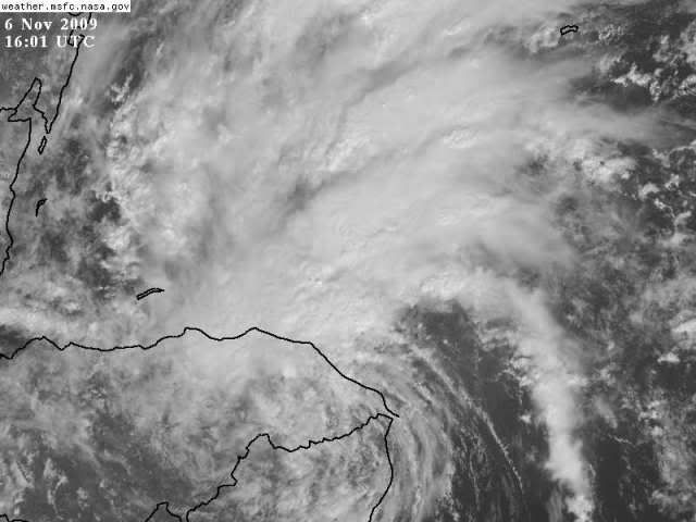
Hurricane Ida rumbled ashore over eastern Nicaragua yesterday morning as a Category 1 hurricane with 75 mph winds--the first November Atlantic hurricane to make landfall in an El Niño year since 1925. Now just a tropical depression, Ida has crossed over into Honduras, dumping heavy rains of 6 - 10 inches along the coast of Nicaragua and northeast Honduras, according to satellite estimates. The rains have pretty much ended over Nicaragua, thanks to the collapse of Ida's heavy thunderstorm activity on the south side of the center. Thunderstorm activity is still strong to the north of the center, over coastal Honduras and the waters of the Western Caribbean. Satellite loops show that Ida still has a vigorous circulation, and with the center due to move offshore tonight, it is apparent that Ida will survive the crossing of Nicaragua and Honduras.

The forecast for Ida

Ida will dump another 1 - 2 inches of rain over northeastern Honduras today. The Cayman Islands, Belize, and the rest of the Honduras coast can expect occasional heavy rains of 1 - 4 inches over the next two days as spiral bands from Ida bring squally weather. Much heavier rains of 4 - 8 inches are likely to affect Mexico's Yucatan Peninsula and Western Cuba beginning Saturday, as Ida heads north towards the Yucatan Channel. Higher rain amounts may occur if Ida intensifies more than forecast.

Moderate wind shear of 15 - 20 knots and warm waters await await Ida when it emerges over the Western Caribbean tonight, and some modest strengthening is likely. It is a concern that Ida could reach Category 1 hurricane strength before it reaches the Yucatan, as the total heat content of the ocean in the Western Caribbean is very high this year (Figure 2). However, given Ida's current disorganized state and the presence of 15 - 20 knots of shear, the odds of the storm reaching hurricane strength before passing the Yucatan on Sunday night are probably low, less than 30%.

The current wind speed probabilities for Cozumel give the Mexican resort island a 26% chance of receiving tropical storm-force winds of 39 mph of higher, Sunday or Monday. I expect Ida will be a tropical storm with 45 - 65 mph winds as it passes Mexico's Yucatan Peninsula and enters the Gulf of Mexico on Monday. Passage over the Yucatan or western Cuba may cause significant weakening. With the shear expected to increase to a high 20 - 30 knots once Ida reaches the Gulf of Mexico on Monday, and with cooler water temperatures there, landfall of Ida as a hurricane on the U.S. coast is unlikely. The long-term fate of Ida once it reaches the Gulf of Mexico is hard to guess at this point, with the models offering a wide range of solutions. While a landfall along the Gulf Coast of Florida is a good bet, the trough of low pressure pulling Ida to the north may speed eastwards fast enough to strand Ida in the Gulf, where it would be forced westwards or southwestwards away from Florida, eventually hitting Texas or Mexico, or simply dissipating in the Gulf due to high wind shear. I give Ida a 50% chance of eventually hitting the U.S. Gulf Coast.
0 likes   
Visit the Caribbean-Central America Weather Thread where you can find at first post web cams,radars
and observations from Caribbean basin members Click Here

User avatar
HURAKAN
Professional-Met
Professional-Met
Posts: 46086
Age: 38
Joined: Thu May 20, 2004 4:34 pm
Location: Key West, FL
Contact:

#1008 Postby HURAKAN » Fri Nov 06, 2009 11:27 am

Image

Hot, hot, hot.
0 likes   

User avatar
ronjon
Category 5
Category 5
Posts: 4822
Joined: Fri Aug 19, 2005 5:17 pm
Location: Hernando Beach, FL

Re: ATL : TROPICAL DEPRESSION IDA

#1009 Postby ronjon » Fri Nov 06, 2009 11:28 am

tolakram wrote:The shear is just not going to fade away, the models are completely clueless about shear normally, and seem worse then normal this year. In my opinion.

Review the shear maps over time. Shear just doesn't quickly fade away, especially since much of it to the north is associated with the jet.

Again, in my opinion. :)


Yeah, but that shear map you posted shows decreasing shear in the NW caribbean where Ida will emerge. I don't think anybody is saying that shear won't increase once in the GOM but the NW caribbean looks like a increasingly favorable UL environment over the next 2-3 days. It's probably why the GFDL and HWRF bring Ida to hurricane strength. Also, I noticed that NHC intensity forecast is on the bottom end (low) of all intensity models the next 72 hrs.
0 likes   

User avatar
HURAKAN
Professional-Met
Professional-Met
Posts: 46086
Age: 38
Joined: Thu May 20, 2004 4:34 pm
Location: Key West, FL
Contact:

#1010 Postby HURAKAN » Fri Nov 06, 2009 11:31 am

NWS MIAMI:

THE WEATHER FOR NEXT WEEK WILL ALL DEPEND ON WHAT TRANSPIRES OF
T.D. IDA NOW OVER CENTRAL AMERICA. NHC FORECASTS IDA TO RE-EMERGE
OFF THE NICARAGUAN COAST ON SATURDAY...THEN HAS IDA MOVING NORTH
INTO THE CENTRAL GULF OF MEXICO BY TUESDAY WHILE INTENSIFYING
INTO A TROPICAL STORM. THERE IS A MUCH HIGHER DEGREE OF
UNCERTAINTY COMPARED TO NORMAL FOR THE EXTENDED FORECAST WITH
WIDELY VARYING MODEL SOLUTIONS ON WHAT COULD TRANSPIRE NEXT WEEK.
FOR INSTANCE...THE 06/00Z ECMWF MODEL TAKES WHAT`S LEFT OF IDA
OVER THE YUCATAN AND INTO THE WESTERN GULF...SHUNTING THE DEEP
TROPICAL MOISTURE WELL TO OUR WEST. THIS WOULD MEAN QUIET WEATHER
LOCALLY. HOWEVER...THE 06/00Z GFS RUN SHOWS A MUCH DIFFERENT
STORY...WITH IDA MOVING INTO THE SE GULF TOWARDS THE SW FL COAST
TUE-WED...WITH A HEAVY RAIN/WIND/TORNADO POTENTIAL ACROSS ALL OF
SOUTH FL. GIVEN THESE UNCERTAINTIES...DID NOT MAKE SIGNIFICANT
CHANGES TO THE EXTENDED FORECAST.
0 likes   

Sanibel
Category 5
Category 5
Posts: 10375
Joined: Mon Aug 30, 2004 11:06 pm
Location: Offshore SW Florida

Re: ATL : TROPICAL DEPRESSION IDA

#1011 Postby Sanibel » Fri Nov 06, 2009 11:33 am

Looks like the red circle is the center and the blue circle is the mid-level jerking into a distorted swirl both because the core is letting go due to land but also because it has been hit by unsymmetrical winds from the imbalance of overwater winds vs overland. All to be sorted out in a few hours with re-emergence.
0 likes   

Aric Dunn
Category 5
Category 5
Posts: 21238
Age: 42
Joined: Sun Sep 19, 2004 9:58 pm
Location: Ready for the Chase.
Contact:

Re:

#1012 Postby Aric Dunn » Fri Nov 06, 2009 11:35 am

HURAKAN wrote:Image

Hot, hot, hot.


Adding to that .. SSTs are 80 all the way up to just past tampa and as for heat content up there it wont matter much if its moving fast.

Image
0 likes   

User avatar
gatorcane
S2K Supporter
S2K Supporter
Posts: 23691
Age: 47
Joined: Sun Mar 13, 2005 3:54 pm
Location: Boca Raton, FL

#1013 Postby gatorcane » Fri Nov 06, 2009 11:40 am

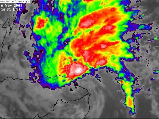
looks like a tropical storm already doesn't it? It hasn't even re-emerged over the Nw Carib yet...pretty amazing. What is also happening is that those big mountains over Nicaragua/Honduras are blocking the inflow from the west. That should be a non-issue in about 24 hours.


The posts in this forum are NOT official forecast and should not be used as such. They are just the opinion of the poster and may or may not be backed by sound meteorological data. They are NOT endorsed by any professional institution or storm2k.org. For official information, please refer to the NHC and NWS products..

Wouldn't surprise me if it becomes a hurricane again by 48 hours.

Lots of deep reds North of the center, that should gradually start to wrap around the center.
Image
0 likes   

Sanibel
Category 5
Category 5
Posts: 10375
Joined: Mon Aug 30, 2004 11:06 pm
Location: Offshore SW Florida

Re:

#1014 Postby Sanibel » Fri Nov 06, 2009 11:51 am

gatorcane wrote:looks like a tropical storm already doesn't it? It hasn't even re-emerged over the Nw Carib yet...pretty amazing. What is also happening is that those big mountains over Nicaragua/Honduras are blocking the inflow from the west. That should be a non-issue in about 24 hours.

Wouldn't surprise me if it becomes a hurricane again by 48 hours.


Not at all. The way I'm reading it is those hearty bands hanging over the Caribbean are going to pull back into the core and fire it up with another intensification burst over waters that are capable of sustaining it.

Not only did 96E steal inflow but the mountain air is also cooler as well. No telling with these things and it could have been busted of any return energy by its overland trip. But the set-up for a refire is obviously there. If this stayed 150 miles east we would probably be watching a high category hurricane.
0 likes   

User avatar
HURAKAN
Professional-Met
Professional-Met
Posts: 46086
Age: 38
Joined: Thu May 20, 2004 4:34 pm
Location: Key West, FL
Contact:

#1015 Postby HURAKAN » Fri Nov 06, 2009 11:51 am

Image

Strong convection developing over the coast
0 likes   

ozonepete
Professional-Met
Professional-Met
Posts: 4743
Joined: Mon Sep 07, 2009 3:23 pm
Location: From Ozone Park, NYC / Now in Brooklyn, NY

Re: ATL : TROPICAL DEPRESSION IDA

#1016 Postby ozonepete » Fri Nov 06, 2009 11:54 am

Aric Dunn wrote:
ozonepete wrote:
artist wrote:
ARic, if you run a water vapor loop you can see a swirl you can follow where the NHC is putting the center, or I can at least. I was surprised as I was tending toward your area as well, until I ran it.


hi Artist. you can't use a water vapor loop to find the center because the wv "seen" by the satellite is always the highest wv if finds. Thus you may be looking at motion only at 30 or 40,000 feet and missing everything else that's going on beneath it in the middle and lower layers. In a case like this where you want to find the LLC, you need a visible or RGB satellite image.


hehe .. just to be picky.. but the RGB is visible but IR as well with the Red, Blue and green color filters or wavelengths to enhance the different heights of some of the clouds. so if you look at it the yellow colors are in the lowest levels and then goes to white and blueish white for the highest clouds. RGB is just a technique :) http://www.ssd.noaa.gov/goes/flt/t2/loop-rgb.html


Thanks for adding that explanation, Aric. I'll bet a lot of people didn't know that.
0 likes   

User avatar
Bocadude85
Category 5
Category 5
Posts: 2991
Age: 38
Joined: Mon Apr 18, 2005 2:20 pm
Location: Honolulu,Hi

Re:

#1017 Postby Bocadude85 » Fri Nov 06, 2009 12:06 pm

gatorcane wrote:looks like a tropical storm already doesn't it? It hasn't even re-emerged over the Nw Carib yet...pretty amazing. What is also happening is that those big mountains over Nicaragua/Honduras are blocking the inflow from the west. That should be a non-issue in about 24 hours.


The posts in this forum are NOT official forecast and should not be used as such. They are just the opinion of the poster and may or may not be backed by sound meteorological data. They are NOT endorsed by any professional institution or storm2k.org. For official information, please refer to the NHC and NWS products..

Wouldn't surprise me if it becomes a hurricane again by 48 hours.

Lots of deep reds North of the center, that should gradually start to wrap around the center.
Image


I have a feeling its going to take sometime for Ida to get her inner core back
0 likes   

User avatar
Ivanhater
Storm2k Moderator
Storm2k Moderator
Posts: 11161
Age: 38
Joined: Fri Jul 01, 2005 8:25 am
Location: Pensacola

Re: ATL : TROPICAL DEPRESSION IDA - Models

#1018 Postby Ivanhater » Fri Nov 06, 2009 12:10 pm

12 CMC shows a petty significant storm for Louisiana

Image
0 likes   
Michael

User avatar
Blown Away
S2K Supporter
S2K Supporter
Posts: 10146
Joined: Wed May 26, 2004 6:17 am

Re: ATL : TROPICAL DEPRESSION IDA

#1019 Postby Blown Away » Fri Nov 06, 2009 12:11 pm

IMO, Ida looks like she has picked up a little forward speed and is wobbling again to the NNE. The circulation is starting to draw in some energy from the very warm NW Caribbean. Looks like Ida will only spend about 24 hours over land which is much less time than originally thought.
http://www.ssd.noaa.gov/goes/flt/t2/loop-vis.html
http://www.ssd.noaa.gov/goes/flt/t2/loop-avn.html

Circulation center touching water now?
0 likes   
Hurricane Eye Experience: David 79, Irene 99, Frances 04, Jeanne 04, Wilma 05... EYE COMING MY WAY IN 2024…
Hurricane Brush Experience: Andrew 92, Erin 95, Floyd 99, Matthew 16, Irma 17, Ian 22, Nicole 22…

User avatar
HURAKAN
Professional-Met
Professional-Met
Posts: 46086
Age: 38
Joined: Thu May 20, 2004 4:34 pm
Location: Key West, FL
Contact:

#1020 Postby HURAKAN » Fri Nov 06, 2009 12:27 pm

Image

Latest microwave
0 likes   


Return to “2009”

Who is online

Users browsing this forum: No registered users and 6 guests