Here is the discussion by Dr Jeff Masters about the forecast of Ida.
Posted by: JeffMasters, 3:04 PM GMT on November 06, 2009
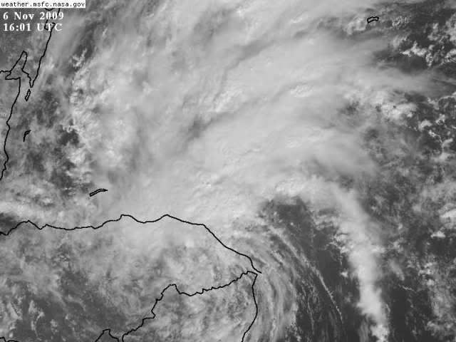
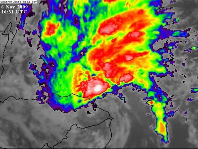
Hurricane Ida rumbled ashore over eastern Nicaragua yesterday morning as a Category 1 hurricane with 75 mph winds--the first November Atlantic hurricane to make landfall in an El Niño year since 1925. Now just a tropical depression, Ida has crossed over into Honduras, dumping heavy rains of 6 - 10 inches along the coast of Nicaragua and northeast Honduras, according to satellite estimates. The rains have pretty much ended over Nicaragua, thanks to the collapse of Ida's heavy thunderstorm activity on the south side of the center. Thunderstorm activity is still strong to the north of the center, over coastal Honduras and the waters of the Western Caribbean. Satellite loops show that Ida still has a vigorous circulation, and with the center due to move offshore tonight, it is apparent that Ida will survive the crossing of Nicaragua and Honduras.
The forecast for Ida
Ida will dump another 1 - 2 inches of rain over northeastern Honduras today. The Cayman Islands, Belize, and the rest of the Honduras coast can expect occasional heavy rains of 1 - 4 inches over the next two days as spiral bands from Ida bring squally weather. Much heavier rains of 4 - 8 inches are likely to affect Mexico's Yucatan Peninsula and Western Cuba beginning Saturday, as Ida heads north towards the Yucatan Channel. Higher rain amounts may occur if Ida intensifies more than forecast.
Moderate wind shear of 15 - 20 knots and warm waters await await Ida when it emerges over the Western Caribbean tonight, and some modest strengthening is likely. It is a concern that Ida could reach Category 1 hurricane strength before it reaches the Yucatan, as the total heat content of the ocean in the Western Caribbean is very high this year (Figure 2). However, given Ida's current disorganized state and the presence of 15 - 20 knots of shear, the odds of the storm reaching hurricane strength before passing the Yucatan on Sunday night are probably low, less than 30%.
The current wind speed probabilities for Cozumel give the Mexican resort island a 26% chance of receiving tropical storm-force winds of 39 mph of higher, Sunday or Monday. I expect Ida will be a tropical storm with 45 - 65 mph winds as it passes Mexico's Yucatan Peninsula and enters the Gulf of Mexico on Monday. Passage over the Yucatan or western Cuba may cause significant weakening. With the shear expected to increase to a high 20 - 30 knots once Ida reaches the Gulf of Mexico on Monday, and with cooler water temperatures there, landfall of Ida as a hurricane on the U.S. coast is unlikely. The long-term fate of Ida once it reaches the Gulf of Mexico is hard to guess at this point, with the models offering a wide range of solutions. While a landfall along the Gulf Coast of Florida is a good bet, the trough of low pressure pulling Ida to the north may speed eastwards fast enough to strand Ida in the Gulf, where it would be forced westwards or southwestwards away from Florida, eventually hitting Texas or Mexico, or simply dissipating in the Gulf due to high wind shear. I give Ida a 50% chance of eventually hitting the U.S. Gulf Coast.
Visit the Caribbean-Central America Weather Thread where you can find at first post web cams,radars
and observations from Caribbean basin members
Click Here