
ATL : TROPICAL DEPRESSION IDA
Moderator: S2k Moderators
-
ocala
- Tropical Depression

- Posts: 88
- Joined: Sat Apr 08, 2006 8:48 am
- Location: Candler,Florida
- Contact:
Re: ATL : TROPICAL STORM IDA
You guys are better versed in TS then me but could we get an eye pretty soon?
0 likes
-
jlauderdal
- S2K Supporter

- Posts: 7240
- Joined: Wed May 19, 2004 5:46 am
- Location: NE Fort Lauderdale
- Contact:
Re: ATL : TROPICAL STORM IDA
ocala wrote:You guys are better versed in TS then me but could we get an eye pretty soon?
i would be surprised if we dont have an eye at some point today, when that would be who knows but its well on its way
0 likes


Re: Tampa discussion. Not making a big deal at all on Ida
cycloneye wrote:robbielyn wrote::( AREA FORECAST DISCUSSION
NATIONAL WEATHER SERVICE TAMPA BAY RUSKIN FL
317 AM EST SAT NOV 7 2009
CORRECTED FOR AVIATION DISCUSSION
.SHORT TERM (TODAY THROUGH MONDAY)...FORECAST FOCUS WILL BE ON
TEMPERATURES IN WHAT WILL REMAIN A VERY QUIET SHORT TERM PERIOD.
THE MAIN WEATHER FEATURE WILL BE A SURFACE RIDGE MOVING OFF THE
COAST OF THE SOUTHEAST US. THIS WILL CONTINUE TO PROVIDE
SEASONABLE TEMPERATURES AND DRY AIR. AS IDA TRACKS NORTH OUT OF
THE CARRIBEAN BY SUNDAY..THE PRESSURE GRADIENT WILL INCREASE
BETWEEN THE STORM AND THE RIDGE. THIS WILL CAUSE SURFACE WINDS TO
INCREASE. ONLY CHANGES TO THE PREVIOUS FORECAST WERE TO RAISE SKY
COVER A BIT EACH DAY...AS THERE LOOKS TO BE A LARGE SHIELD OF MID
AND HIGH CLOUDS COVERING MOST OF THE WESTERN AND CENTRAL GULF
CURRENTLY. TEMPERATURES WILL REMAIN NEAR NORMAL FOR TODAY AND THEN
SLOWLY WARM A FEW DEGREES EACH DAY. THIS WILL OCCUR AS AN H5 RIDGE
STRENGTHENS ATOP FLORIDA. GIVEN EXPECTED CLOUDS AND THE ACTUAL H8
TEMPERATURES THE MAV MOS SEEMED TO BE TOO HIGH ON THE SURFACE
TEMPERATURES THIS PERIOD AND SO WENT WITH A BLENDED SOLUTION.
.LONG TERM (MONDAY NIGHT THROUGH FRIDAY)...FORECAST IS BEGINNING
TO GAIN A LITTLE MORE CLARITY THIS MORNING WITH REGARDS TO THE
EVOLUTION OF TROPICAL STORM IDA. WITH IDA CURRENTLY IN THE WARM
WATERS OF THE NW CARIBBEAN...A NORTHWARD PROPAGATION INTO THE
GOMEX AS A TROPICAL STORM IS ANTICIPATED BY NHC. LATEST MODEL
GUIDANCE SHOWS SOMEWHAT MORE AGREEMENT TO THE OVERALL PATH OF IDA
AND THE ASSOCIATED MOISTURE EVEN THOUGH THE ECMWF STILL TRACKS A
LITTLE MORE WEST OF THE GFS SOLUTION.
I merged the topic that you made with the main discussion thread of Ida as only threads for Invest and Tropical Cyclones are allowed in this forum.
Oops my bad
0 likes
Robbielyn McCrary
I know just about enough to sound like I know what I'm talking about sometimes. But for your safety please follow the nhc for truly professional forecasting.
I know just about enough to sound like I know what I'm talking about sometimes. But for your safety please follow the nhc for truly professional forecasting.
Re: ATL : TROPICAL STORM IDA
Ida is moving over the highest tchp (tropical cyclone heat potential) region...this could be high-octane fuel for her

0 likes
-
cycloneye

- Admin

- Posts: 149227
- Age: 69
- Joined: Thu Oct 10, 2002 10:54 am
- Location: San Juan, Puerto Rico
Re: ATL : TROPICAL STORM IDA
Oops my bad
Thats ok,no problem.
0 likes
Visit the Caribbean-Central America Weather Thread where you can find at first post web cams,radars
and observations from Caribbean basin members Click Here
and observations from Caribbean basin members Click Here


-
cycloneye
- Admin
- Posts: 149227
- Age: 69
- Joined: Thu Oct 10, 2002 10:54 am
- Location: San Juan, Puerto Rico
Re:
HURAKAN wrote:
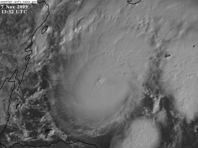
But an eye is forming.
Impressive.They may have to bump winds to 55-60kts at 10 AM.
0 likes
Visit the Caribbean-Central America Weather Thread where you can find at first post web cams,radars
and observations from Caribbean basin members Click Here
and observations from Caribbean basin members Click Here
-
jlauderdal
- S2K Supporter
- Posts: 7240
- Joined: Wed May 19, 2004 5:46 am
- Location: NE Fort Lauderdale
- Contact:

-
Blown Away

- S2K Supporter
- Posts: 10253
- Joined: Wed May 26, 2004 6:17 am
Re: ATL : TROPICAL STORM IDA
12 UTC Best Track
In line with SSD Dvorak,45kts.
AL, 11, 2009110712, , BEST, 0, 174N, 841W, 45, 1000, TS
ftp://ftp.tpc.ncep.noaa.gov/atcf/tcweb/ ... 009.invest
Looks like that center is east of 84W by a few degrees?
Last edited by Blown Away on Sat Nov 07, 2009 8:33 am, edited 1 time in total.
0 likes
Hurricane Eye Experience: David 79, Irene 99, Frances 04, Jeanne 04, Wilma 05… Hurricane Brush Experience: Andrew 92, Erin 95, Floyd 99, Matthew 16, Irma 17, Ian 22, Nicole 22…


Re: ATL : TROPICAL STORM IDA
Ivanhater wrote: GFS windshear forecast ..not good
Not good for Ida or for the people in the gulf?
0 likes

-
Ivanhater

- Storm2k Moderator

- Posts: 11221
- Age: 39
- Joined: Fri Jul 01, 2005 8:25 am
- Location: Pensacola
Re: ATL : TROPICAL STORM IDA
Macrocane wrote:Ivanhater wrote: GFS windshear forecast ..not good
Not good for Ida or for the people in the gulf?
The windshear forecast for the gulf according to the GFS has backed off significant shear in the gulf. At 66 hours, when Ida is nearing the north central gulfcoast, windshear is light
0 likes
Michael
-
Dean4Storms
- S2K Supporter
- Posts: 6358
- Age: 63
- Joined: Sun Aug 31, 2003 1:01 pm
- Location: Miramar Bch. FL
Ivan, looks this morning that a consensus is starting to gain favor of a Panhandle landfall or very near close before any loop takes place. I can see a 40-60mph wind with this but I would doubt anything stronger. I'm also thinking with the front approaching and the changing wind directions with height that this could have a higher threat of Tornadoes/Waterspouts.
0 likes

Re: ATL : TROPICAL STORM IDA - Recon
cycloneye wrote:The mission for today was supposed to haved been in the air since 6:15 AM EST.But still no obs yet.Maybe,they will depart from a base much closer,Homestead base?
would make more sense so they could fly longer in the storm itself
0 likes
-
deltadog03

- Professional-Met

- Posts: 3580
- Joined: Tue Jul 05, 2005 6:16 pm
- Location: Macon, GA
Re: ATL : TROPICAL STORM IDA
Ivanhater wrote:GFS windshear forecast ..not good
IF** that map is correct then the GFS not only is telling you where it thinks she is going, but saying look out as well!
0 likes
Who is online
Users browsing this forum: No registered users and 9 guests