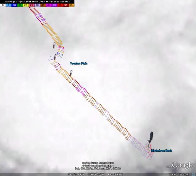
Sanibel wrote:Can't figure why the eye is deforming like that? Intensification?
Most likely- i think the eye will emerge somewhat medium and round
Moderator: S2k Moderators


Sanibel wrote:Can't figure why the eye is deforming like that? Intensification?


LaBreeze wrote:Shock us how?
attallaman wrote:Which model is the most reliable and if the storm does make landfall as a CAT 2 into the FL panhandle what kind of weather could I possibly experience here in Biloxi? Lots of rain and some wind or stronger winds and lots of rain?Evil Jeremy wrote:LaBreeze wrote:What is the GFDL saying?
Cat 2 landfall on the western panhandle.
BigA wrote:Does the UKMET have a graphic or a link?
Alacane2 wrote:Is there any chance that Ida could make landfall as far west as Mobile?


Blown_away wrote:BTW, Ida still moving WNW on the radar towards Cancun.


Say what? Is that Euro reliable? Nothing good on TV earlier tonight but being here has certainly been interesting to say the least.deltadog03 wrote:EURO says hello to gulfport/biloxi/just east of NOLA on tues 00z..... so, basically monday night late. SFC pressure is around 996-998mb ish. Not bad from a global. So ****IF these runs tonight are close to being right** then 975-980mb at landfall is not that far fetched.
attallaman wrote:Was George a CAT 2 when it made landfall near here in 1998?deltadog03 wrote:Cat 2 at landfall it appears on this run from the GFDL
Users browsing this forum: No registered users and 75 guests