
Global model runs discussion
Moderator: S2k Moderators
-
cycloneye

- Admin

- Posts: 149508
- Age: 69
- Joined: Thu Oct 10, 2002 10:54 am
- Location: San Juan, Puerto Rico
Re: Long / Medium Range Model Runs
For the past few runs,GFS has been showing something developing in the SW Caribbean but is almost 2 weeks ahead so you know the drill about that. However,its getting closer to that time of the year when things start to pop in that area.
00z GFS
http://www.nco.ncep.noaa.gov/pmb/nwprod ... loop.shtml

00z GFS
http://www.nco.ncep.noaa.gov/pmb/nwprod ... loop.shtml
0 likes
Visit the Caribbean-Central America Weather Thread where you can find at first post web cams,radars
and observations from Caribbean basin members Click Here
and observations from Caribbean basin members Click Here


Re: Long / Medium Range Model Runs
0 likes
-
cycloneye
- Admin
- Posts: 149508
- Age: 69
- Joined: Thu Oct 10, 2002 10:54 am
- Location: San Juan, Puerto Rico
Re: Long / Medium Range Model Runs
What GFS is showing in the past few days coincides with a MJO pulse that will arrive at the EPAC/SW Caribbean by late April /early May.
0 likes
Visit the Caribbean-Central America Weather Thread where you can find at first post web cams,radars
and observations from Caribbean basin members Click Here
and observations from Caribbean basin members Click Here
Re: Long / Medium Range Model Runs
Arthur
Dolly
Fay, Gustav, Hanna, Ike
Omar, Sixteen
All of them formed during a wet phase of the MJO.
0 likes
-
cycloneye
- Admin
- Posts: 149508
- Age: 69
- Joined: Thu Oct 10, 2002 10:54 am
- Location: San Juan, Puerto Rico
Re: Long / Medium Range Model Runs
It looks like GFS has setteled for the EPAC side.

0 likes
Visit the Caribbean-Central America Weather Thread where you can find at first post web cams,radars
and observations from Caribbean basin members Click Here
and observations from Caribbean basin members Click Here
Re: Long / Medium Range Model Runs
And the GFS doesn't decide yet where the tropical system is going to develop, on the last run it develops a strong system in the EPAC, but it is still on the very long range so everything culd change:

0 likes
-
tolakram
- Admin
- Posts: 20186
- Age: 62
- Joined: Sun Aug 27, 2006 8:23 pm
- Location: Florence, KY (name is Mark)
Re: Long / Medium Range Model Runs
Just like last year and the year before. If the models develop something in the ATL you can bet it's real location will be the EPAC. May 15th getting close. 
0 likes
M a r k
- - - - -
Join us in chat: Storm2K Chatroom Invite. Android and IOS apps also available.
The posts in this forum are NOT official forecasts and should not be used as such. Posts are NOT endorsed by any professional institution or STORM2K.org. For official information and forecasts, please refer to NHC and NWS products.
-
cycloneye
- Admin
- Posts: 149508
- Age: 69
- Joined: Thu Oct 10, 2002 10:54 am
- Location: San Juan, Puerto Rico
Re: Long / Medium Range Model Runs
For now is only GFS that is showing this because is the model that has the longest range in time.I am eagered to see what ECMWF may have when the 10 days arrive for it to start to show something.
0 likes
Visit the Caribbean-Central America Weather Thread where you can find at first post web cams,radars
and observations from Caribbean basin members Click Here
and observations from Caribbean basin members Click Here
-
wxman57

- Moderator-Pro Met

- Posts: 23175
- Age: 68
- Joined: Sat Jun 21, 2003 8:06 pm
- Location: Houston, TX (southwest)
Re: Long / Medium Range Model Runs
Three weeks ago, the GFS was forecasting a deep low tracking ENE across the Gulf of Mexico for last Wed-Thu. It kept forecasting the deep low right up until 5-6 days before the event, then it dropped it.
0 likes
-
cycloneye
- Admin
- Posts: 149508
- Age: 69
- Joined: Thu Oct 10, 2002 10:54 am
- Location: San Juan, Puerto Rico
Re: Long / Medium Range Model Runs
Now GFS has it forming on the Caribbean side.Waiting on ECMWF.
http://www.nco.ncep.noaa.gov/pmb/nwprod ... loop.shtml
http://www.nco.ncep.noaa.gov/pmb/nwprod ... loop.shtml
0 likes
Visit the Caribbean-Central America Weather Thread where you can find at first post web cams,radars
and observations from Caribbean basin members Click Here
and observations from Caribbean basin members Click Here
-
gatorcane

- S2K Supporter

- Posts: 23708
- Age: 48
- Joined: Sun Mar 13, 2005 3:54 pm
- Location: Boca Raton, FL
12Z and 18Z GFS still showing development in the Caribbean with the low drifting NW out around 12+ days. Obviously its very far out. I did follow a low that the GFS was forecasting to develop in the NW Carib and track NE into the Bahamas. At around 12-14 days out it showed this feature and it ended up being a weak surface low attached to a frontal system that pushed ENE-NE through the FL straits. That was the low that pushed through South FL last weekend.
The posts in this forum are NOT official forecast and should not be used as such. They are just the opinion of the poster and may or may not be backed by sound meteorological data. They are NOT endorsed by any professional institution or storm2k.org. For official information, please refer to the NHC and NWS products.
It's quite possible looking at the long-range MJO forecasts and GFS forecasts that we get a broad area of disturbed weather in the extreme Southern Caribbean and EPAC and through Panama around 12-14 days from now. Most likley this area will drift into the EPAC and not be an area that will consolidate in the Caribbean.
0 likes
-
Ivanhater

- Storm2k Moderator

- Posts: 11221
- Age: 39
- Joined: Fri Jul 01, 2005 8:25 am
- Location: Pensacola
Re: Long / Medium Range Model Runs
Well if you remember last year during Memorial Day Weekend, there was a system in the Gulf that was very close to being named, Invest 90L. Heavy rain and storm surge on the North Central Gulf coast, so it is possible.
This image from last years system

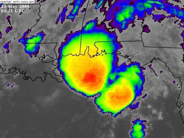
This image from last years system
0 likes
Michael
-
wxman57
- Moderator-Pro Met
- Posts: 23175
- Age: 68
- Joined: Sat Jun 21, 2003 8:06 pm
- Location: Houston, TX (southwest)
Re: Long / Medium Range Model Runs
The GFS always tries to develop something in the western Caribbean in May. This year, the Gulf is quite a bit cooler than last year, though. I'll believe it when it's showing development within 5 days and the ECMWF agrees.
0 likes
-
cycloneye
- Admin
- Posts: 149508
- Age: 69
- Joined: Thu Oct 10, 2002 10:54 am
- Location: San Juan, Puerto Rico
Re: Long / Medium Range Model Runs
The extreme Eastern Pacific area may turn favorable as the wet MJO moves thru and low level convergence increases and that is why some models are semi bullish more so GFS.


0 likes
Visit the Caribbean-Central America Weather Thread where you can find at first post web cams,radars
and observations from Caribbean basin members Click Here
and observations from Caribbean basin members Click Here
-
gatorcane
- S2K Supporter
- Posts: 23708
- Age: 48
- Joined: Sun Mar 13, 2005 3:54 pm
- Location: Boca Raton, FL
12Z GFS wants to spin off some energy from the ITCZ and form a surface low and associated tropical wave that traverses the Southern Caribbean with strong ridging to the north (strong Bermuda High) over most of the Western Atlantic and Caribbean. It's far out there but the hints that tropical season is near are certainly there:


0 likes
-
cycloneye
- Admin
- Posts: 149508
- Age: 69
- Joined: Thu Oct 10, 2002 10:54 am
- Location: San Juan, Puerto Rico
Re: Long / Medium Range Model Runs
Nothing yet from ECMWF.
0 likes
Visit the Caribbean-Central America Weather Thread where you can find at first post web cams,radars
and observations from Caribbean basin members Click Here
and observations from Caribbean basin members Click Here
-
Ivanhater
- Storm2k Moderator
- Posts: 11221
- Age: 39
- Joined: Fri Jul 01, 2005 8:25 am
- Location: Pensacola
Re: Long / Medium Range Model Runs
Well if this image doesn't show you that tropical season is knocking, I don't know what will.
Tropical storm in the EPAC, tropical disturbance/depression in the Atl.
Not to mention the 06z GFS, showing dual tropical storms in the ATL

Tropical storm in the EPAC, tropical disturbance/depression in the Atl.
Not to mention the 06z GFS, showing dual tropical storms in the ATL
0 likes
Michael
-
Dean4Storms
- S2K Supporter
- Posts: 6358
- Age: 63
- Joined: Sun Aug 31, 2003 1:01 pm
- Location: Miramar Bch. FL
Re: Long / Medium Range Model Runs
If things start out like this, it will be a LONG hurricane season I'm afraid!
0 likes
Who is online
Users browsing this forum: No registered users and 51 guests