SE TX/SW LA weather: Much cooler and WET after Tuesday
Moderator: S2k Moderators
Forum rules

The posts in this forum are NOT official forecast and should not be used as such. They are just the opinion of the poster and may or may not be backed by sound meteorological data. They are NOT endorsed by any professional institution or STORM2K.
-
vbhoutex

- Storm2k Executive

- Posts: 29149
- Age: 74
- Joined: Wed Oct 09, 2002 11:31 pm
- Location: Cypress, TX
- Contact:
Re: SE TX/SW LA weather: Increasing rain chances thru Sat.
You definitely got a much heavier storm than we did. We ended up with 0.55" total from this round of rain. We still need more rain but we can wait a few days for some more.
0 likes
Skywarn, C.E.R.T.
Please click below to donate to STORM2K to help with the expenses of keeping the site going:

Please click below to donate to STORM2K to help with the expenses of keeping the site going:
-
southerngale

- Retired Staff

- Posts: 27418
- Joined: Thu Oct 10, 2002 1:27 am
- Location: Southeast Texas (Beaumont area)
I didn't get much rain at my house. It was raining lightly when I left yesterday morning, but no sign of rain when I got home last night. I was at a friend's house all afternoon and it rained there much of the day, although it was pretty light.
0 likes
Please support Storm2k by making a donation today. It is greatly appreciated! Click here:
 my Cowboys my Rockets my Astros
my Cowboys my Rockets my Astros-
southerngale
- Retired Staff
- Posts: 27418
- Joined: Thu Oct 10, 2002 1:27 am
- Location: Southeast Texas (Beaumont area)
-
wxman57

- Moderator-Pro Met

- Posts: 23175
- Age: 68
- Joined: Sat Jun 21, 2003 8:06 pm
- Location: Houston, TX (southwest)
Re: SE TX/SW LA weather: Increasing rain chances thru Sat.
I did get 1.9" in southwest Houston (Westbury) last Sunday. Heaviest rain all year.
0 likes
-
southerngale
- Retired Staff
- Posts: 27418
- Joined: Thu Oct 10, 2002 1:27 am
- Location: Southeast Texas (Beaumont area)
I'll be traveling to Tyler Saturday morning. I wasn't thrilled to see this Special Weather Statement this morning. Hopefully, it will pass sooner than expected. I don't mind traveling in the rain, but prefer not to travel in large hail, damaging winds, and tornadoes. 
Special Weather Statement
SPECIAL WEATHER STATEMENT
NATIONAL WEATHER SERVICE LAKE CHARLES LA
451 AM CDT THU APR 22 2010
LAZ027>033-041>045-051>055-TXZ180>182-201-215-216-222100-
VERNON-RAPIDES-AVOYELLES-BEAUREGARD-ALLEN-EVANGELINE-ST. LANDRY-
CALCASIEU-JEFFERSON DAVIS-ACADIA-LAFAYETTE-UPPER ST. MARTIN-
CAMERON-VERMILION-IBERIA-ST. MARY-LOWER ST. MARTIN-TYLER-JASPER-
NEWTON-HARDIN-JEFFERSON-ORANGE-
INCLUDING THE CITIES OF...LEESVILLE...ALEXANDRIA...MARKSVILLE...
DERIDDER...OAKDALE...VILLE PLATTE...OPELOUSAS...LAKE CHARLES...
JENNINGS...CROWLEY...LAFAYETTE...ST. MARTINVILLE...CAMERON...
ABBEVILLE...NEW IBERIA...MORGAN CITY...WOODVILLE...JASPER...
NEWTON...LUMBERTON...BEAUMONT/PORT ARTHUR...ORANGE
451 AM CDT THU APR 22 2010
...SEVERE THUNDERSTORMS ARE POSSIBLE FRIDAY AND SATURDAY...
A POWERFUL UPPER LEVEL STORM SYSTEM FORECAST TO MOVE ACROSS TEXAS
AND LOUISIANA THE NEXT SEVERAL DAYS WILL INTERACT WITH A WARM AND
HUMID AIRMASS IN PLACE TO BRING SCATTERED SHOWERS AND
THUNDERSTORMS TO THE ENTIRE AREA FROM FRIDAY INTO SATURDAY.
DUE TO THE STRENGTH OF THIS STORM SYSTEM...SEVERE THUNDERSTORMS
APPEAR POSSIBLE OVER A LONG PERIOD OF TIME FROM FRIDAY AFTERNOON
THROUGH SATURDAY AFTERNOON. LARGE HAIL...DAMAGING WINDS...AND
ISOLATED TORNADOES ARE ALL POSSIBLE WITH ANY SEVERE THUNDERSTORMS
THAT DEVELOP DURING THIS TIME.
LISTEN TO NOAA WEATHER RADIO OR YOUR LOCAL MEDIA FOR THE LATEST
UPDATES ON THIS POTENTIAL SEVERE WEATHER SITUATION.
$$
SHAMBURGER
0 likes
Please support Storm2k by making a donation today. It is greatly appreciated! Click here:
my Cowboys my Rockets my Astros
my Cowboys my Rockets my Astros-
PTrackerLA

- Category 5

- Posts: 5281
- Age: 42
- Joined: Thu Oct 10, 2002 8:40 pm
- Location: Lafayette, LA
Re: SE TX/SW LA weather: Increasing rain chances thru Sat.
All of south LA could use the rain, shame it has to happen with some big festivals going on this weekend but I'll take it.
0 likes
-
SETXWXLADY
- Tropical Storm

- Posts: 216
- Joined: Wed May 20, 2009 3:26 pm
- Location: SE TX Orange County
Re:
JenBayles wrote:Looks like the cap will protect West Houston tonight and tomorrow morning - for the most part. I did notice the discussion mentioned the front/trough will slow and nearly stall out nearby, which makes me a bit nervous. Any predictions on that?
This was on channel 12 site this morning. Not exactly Houston but he explained things to where I could understand them. Hope it helps.
http://www.12newsnow.com/global/category.asp?c=177961&autoStart=true&topVideoCatNo=default&clipId=4727478&flvUri=&partnerclipid=
0 likes
-
JenBayles

- Category 5
- Posts: 3461
- Age: 63
- Joined: Tue Aug 26, 2003 3:27 pm
- Location: Houston, TX
- Contact:
Re: SE TX/SW LA weather: Increasing rain chances thru Sat.
Thanks for posting that video. It's a great, easily understood explanation of this system - even for a blonde! 
0 likes
-
jasons2k

- Storm2k Executive
- Posts: 8290
- Age: 52
- Joined: Wed Jul 06, 2005 12:32 pm
- Location: The Woodlands, TX
Re: SE TX/SW LA weather: Increasing rain chances thru Sat.
I'm watching, Jen. I went outside and looked at the sky - pretty spooky. The LLJ is howling from the SSE - you can see the low clouds racing north in the moonlight.
0 likes
-
JenBayles
- Category 5
- Posts: 3461
- Age: 63
- Joined: Tue Aug 26, 2003 3:27 pm
- Location: Houston, TX
- Contact:
Hey Jason! Yes, the LLJ is very active tonight - already have storms moving along the upper Gulf coast. And talk about humid? It feels almost like an August night out there with toads and frogs making a lot of noise too. Don't need to look at the radar to know something wicked this way comes.
[Edit,2:00 am] Hmmm... maybe not. The southern end of the line below I-10 has really fallen apart now. The Bear Creek Dome may not get tested tonight!
[Edit,2:00 am] Hmmm... maybe not. The southern end of the line below I-10 has really fallen apart now. The Bear Creek Dome may not get tested tonight!
0 likes

Re: SE TX/SW LA weather: Increasing rain chances thru Sat.
With all of my prayers for some rain we got this: Watch what you wish for huh!
Flood Warning
Flood Advisory
Special Weather Statement
Hazardous Weather Outlook
Short Term Forecast
Severe Thunderstorm Warning
Results so far:
0.01 Precipitation
I'm telling ya...........................the weather god's are messing with me.
Flood Warning
Flood Advisory
Special Weather Statement
Hazardous Weather Outlook
Short Term Forecast
Severe Thunderstorm Warning
Results so far:
0.01 Precipitation
I'm telling ya...........................the weather god's are messing with me.
0 likes
-
jasons2k
- Storm2k Executive
- Posts: 8290
- Age: 52
- Joined: Wed Jul 06, 2005 12:32 pm
- Location: The Woodlands, TX
Re: SE TX/SW LA weather: Increasing rain chances thru Sat.
Looks like nothing here overnight. Might have to run the sprinklers this weekend. Sure feels nice outside though.
0 likes
Re: SE TX/SW LA weather: Increasing rain chances thru Sat.
Well, we missed out on the liquid stuff AGAIN. My son was trying to bury an electrical line in my yard today. He's a big man and he'd pound that shovel with all his might and felt like he was trying to cut through concrete. The dust would fly. Hmmmmmm, it's a good thing I've been watering but it looks like I need alot more. Seems that a mere 20% is the best chance we have of possibly seeing any rain for the entire week now. Sigh....................more watering in my future.
0 likes
-
srainhoutx

- S2K Supporter

- Posts: 6919
- Age: 68
- Joined: Sun Jan 14, 2007 11:34 am
- Location: Haywood County, NC
- Contact:
Re: SE TX/SW LA weather: Increasing rain chances thru Sat.
Surprise! 
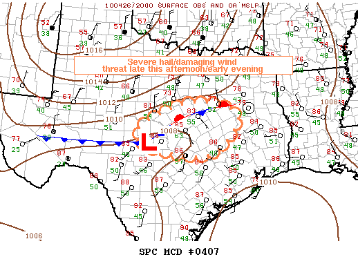
MESOSCALE DISCUSSION 0407
NWS STORM PREDICTION CENTER NORMAN OK
0338 PM CDT MON APR 26 2010
AREAS AFFECTED...CENTRAL TX
CONCERNING...SEVERE POTENTIAL...WATCH POSSIBLE
VALID 262038Z - 262215Z
AT LEAST ISOLATED TSTMS SHOULD DEVELOP THROUGH LATE AFTERNOON/EARLY
EVENING AND POTENTIALLY BECOME SEVERE ACROSS SOUTH CENTRAL TX
INCLUDING PORTIONS OF THE HILL COUNTRY. SEVERE HAIL/DAMAGING WINDS
WILL BE THE PRIMARY HAZARDS. THE NEED FOR A WATCH IS UNCLEAR...BUT
CONVECTIVE TRENDS WILL CONTINUE TO BE MONITORED.
DEEPENING/EXPANDING CUMULUS FIELD EXISTS IN VICINITY OF FRONTAL
ZONE/LOOSE TRIPLE POINT ACROSS SOUTH CENTRAL TX...NEAR A SURFACE LOW
BETWEEN THE MORE SOUTHWARD-AGGRESSIVE SURGING FRONT ACROSS WEST TX
AND THE STALLED/NEARLY STATIONARY PORTION OF THE FRONT ACROSS EAST
CENTRAL TO NORTHEAST TX. THIS IS OCCURRING WITHIN A WARM /80S
F/..MODESTLY MOIST /MAINLY LOWER TO MIDDLE 50S F SURFACE
DEWPOINTS/...AND WEAKLY CAPPED BOUNDARY LAYER. IT SEEMS PROBABLE
THAT ISOLATED TO SCATTERED TSTMS WILL DEVELOP/INCREASE THROUGH LATE
AFTERNOON...AIDED BY FRONTAL CONVERGENCE AND PERHAPS A SPEED MAX
ACROSS OK/NORTH TX. VEERING WIND PROFILES BENEATH MODERATELY STRONG
W-NW FLOW ALOFT /40-60 KT PER LBD AND JTN PROFILERS/ WOULD SUPPORT
SOME RELATIVELY HIGH BASED SUPERCELLS AND/OR ORGANIZED
SOUTHEAST-MOVING LINE SEGMENTS CAPABLE OF SEVERE HAIL/DAMAGING WINDS
THROUGH EARLY EVENING. WHILE THE OVERALL EXTENT/MAGNITUDE OF THE
SEVERE RISK WILL LIKELY BE TEMPERED BY MARGINAL MOISTURE/TOTAL
BUOYANCY...CONVECTIVE TRENDS WILL BE MONITORED FOR A POSSIBLE WATCH.
..GUYER.. 04/26/2010
ATTN...WFO...HGX...FWD...EWX...SJT...
0 likes
Carla/Alicia/Jerry(In The Eye)/Michelle/Charley/Ivan/Dennis/Katrina/Rita/Wilma/Ike/Harvey
Member: National Weather Association
Wx Infinity Forums
http://wxinfinity.com/index.php
Facebook.com/WeatherInfinity
Twitter @WeatherInfinity
Member: National Weather Association
Wx Infinity Forums
http://wxinfinity.com/index.php
Facebook.com/WeatherInfinity
Twitter @WeatherInfinity
-
jasons2k
- Storm2k Executive
- Posts: 8290
- Age: 52
- Joined: Wed Jul 06, 2005 12:32 pm
- Location: The Woodlands, TX
Re: SE TX/SW LA weather: Increasing temps-90 by Sat.?
That storm headed close to Bryan is a right-turning supercell and needs to be watched.
0 likes
Return to “USA & Caribbean Weather”
Who is online
Users browsing this forum: AnnularCane and 76 guests