ENSO Updates (2007 thru 2023)
Moderator: S2k Moderators
Forum rules

The posts in this forum are NOT official forecasts and should not be used as such. They are just the opinion of the poster and may or may not be backed by sound meteorological data. They are NOT endorsed by any professional institution or STORM2K. For official information, please refer to products from the National Hurricane Center and National Weather Service.


Possibly jinftl but if anything we are actually taking longer to get out of this El Nino then you'd expect if you are going to get a La Nina, as I said before most years that develop La Nina are already pretty much bang on 0.0C or already developing a weak La Nina signal...whilst the El Nino is weakening, we are still in an El Nino and I'd like to see a stronger weakening signals before getting too interested about any possible La Nina.
0 likes
Personal Forecast Disclaimer:
The posts in this forum are NOT official forecast and should not be used as such. They are just the opinion of the poster and may or may not be backed by sound meteorological data. They are NOT endorsed by any professional institution or storm2k.org. For official information, please refer to the NHC and NWS products
The posts in this forum are NOT official forecast and should not be used as such. They are just the opinion of the poster and may or may not be backed by sound meteorological data. They are NOT endorsed by any professional institution or storm2k.org. For official information, please refer to the NHC and NWS products
-
cycloneye

- Admin

- Posts: 149156
- Age: 69
- Joined: Thu Oct 10, 2002 10:54 am
- Location: San Juan, Puerto Rico
Re: ENSO Updates=CPC update=+0.7C / 30 day SOI Index=+15.0
The Australians update of El Nino 3.4 area continues to show the rate that it is falling,now to +0.6C. The number of Neutral conditions is +0.5C.

0 likes
Visit the Caribbean-Central America Weather Thread where you can find at first post web cams,radars
and observations from Caribbean basin members Click Here
and observations from Caribbean basin members Click Here
It seems to be falling between 0.07-0.09C a week pretty much, so we will be reaching neutral soon enough based on that, what happens afterwards though is not quite such an easy call, certainly looks likely we will be neutral for the start of the season though now!
0 likes
Personal Forecast Disclaimer:
The posts in this forum are NOT official forecast and should not be used as such. They are just the opinion of the poster and may or may not be backed by sound meteorological data. They are NOT endorsed by any professional institution or storm2k.org. For official information, please refer to the NHC and NWS products
The posts in this forum are NOT official forecast and should not be used as such. They are just the opinion of the poster and may or may not be backed by sound meteorological data. They are NOT endorsed by any professional institution or storm2k.org. For official information, please refer to the NHC and NWS products
-
cycloneye
- Admin
- Posts: 149156
- Age: 69
- Joined: Thu Oct 10, 2002 10:54 am
- Location: San Juan, Puerto Rico
Re: ENSO Updates=CPC update=+0.7C / 30 day SOI Index=+15.0
meteorologyman wrote:Cycloneye, out of curiosity, for comparison, do you have any SOI data from 2005?
No,I dont have the 2005 data. But lets see if other members have that information for you.
0 likes
Visit the Caribbean-Central America Weather Thread where you can find at first post web cams,radars
and observations from Caribbean basin members Click Here
and observations from Caribbean basin members Click Here
-
cycloneye
- Admin
- Posts: 149156
- Age: 69
- Joined: Thu Oct 10, 2002 10:54 am
- Location: San Juan, Puerto Rico
Re: ENSO Updates=30 day SOI Index continues to spike up=+15.0
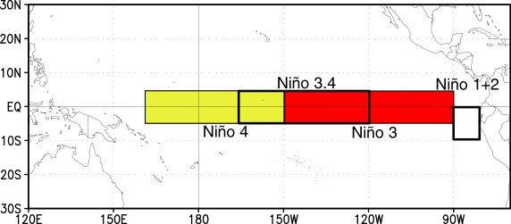
For those members that are newbies in the board or for those who dont know a lot about how are the different areas of ENSO divided here is a graphic that explains that. El Nino 3.4 the most important area of ENSO goes from 120W to 170W.
0 likes
Visit the Caribbean-Central America Weather Thread where you can find at first post web cams,radars
and observations from Caribbean basin members Click Here
and observations from Caribbean basin members Click Here
-
cycloneye
- Admin
- Posts: 149156
- Age: 69
- Joined: Thu Oct 10, 2002 10:54 am
- Location: San Juan, Puerto Rico
Re: ENSO Updates=30 day SOI Index continues to spike up=+15.7
The 30 day SOI index doesn't want to stop its spike up as tonigh't update is at +15.7.
http://www.longpaddock.qld.gov.au/Seaso ... SOIValues/
http://www.bom.gov.au/climate/enso/soi.txt

http://www.longpaddock.qld.gov.au/Seaso ... SOIValues/
http://www.bom.gov.au/climate/enso/soi.txt
0 likes
Visit the Caribbean-Central America Weather Thread where you can find at first post web cams,radars
and observations from Caribbean basin members Click Here
and observations from Caribbean basin members Click Here
-
Ivanhater

- Storm2k Moderator

- Posts: 11221
- Age: 39
- Joined: Fri Jul 01, 2005 8:25 am
- Location: Pensacola
Re: ENSO Updates=30 day SOI Index continues to spike up=+15.7
It is higher now than it ever was during the 2009 Hurricane Season
0 likes
Michael
-
cycloneye
- Admin
- Posts: 149156
- Age: 69
- Joined: Thu Oct 10, 2002 10:54 am
- Location: San Juan, Puerto Rico
Re: ENSO Updates=CPC update=+0.7C / 30 day SOI Index=+15.0
meteorologyman wrote:Cycloneye, out of curiosity, for comparison, do you have any SOI data from 2005?
I found a graphic that includes 2005. It was mainly positive during the hurricane season.

0 likes
Visit the Caribbean-Central America Weather Thread where you can find at first post web cams,radars
and observations from Caribbean basin members Click Here
and observations from Caribbean basin members Click Here
-
meteorologyman
- Category 2

- Posts: 541
- Joined: Wed Mar 15, 2006 6:48 pm
- Location: Florida, Kissimmee/St.CLoud
Re: ENSO Updates=30 day SOI Index continues to spike up=+15.7
Thank you 

Well this SOI threw me off a little bit on how it correlates with hurricane seasons, I know (negative values) Sometimes means el-nino event, low trade winds and high Ocean Temps in Pacific (positive values) is exact opposite.
Reason why I'm confuse because 2004 had (negative SOI) which was very active in the Atlantic though it was not an el-nino event and 2005 was (positive SOI) which was a hyper active season, both years was nuetral ENSO
0 likes
-
cycloneye
- Admin
- Posts: 149156
- Age: 69
- Joined: Thu Oct 10, 2002 10:54 am
- Location: San Juan, Puerto Rico
Re: ENSO Updates
Australian's update of ENSO=Neutral Conditions are present
The Aussies jumped the line from El Nino to Neutral. But still Climate Prediction Center is in the Weak El Nino threshold but getting closer to proclaim it Neutral.
http://www.bom.gov.au/climate/enso/
ENSO Wrap-Up: Neutral conditions returning to the Pacific
Issued on Wednesday 28 April 2010
Apart from some lingering warmth in the western Pacific, the majority of ENSO indicators have now dropped below El Niño thresholds. The cooling of the tropical Pacific Ocean, which began in late December, has resulted in trade winds and tropical cloudiness returning to normal. Similarly, the Southern Oscillation Index has risen steadily, remaining positive since early in the second week of April.
Southern Oscillation Index:
The SOI has been rising steadily since late February 2010. The current (25 April) 30-day value is +16, a large increase from the montly value for March of −11.
Sustained positive values of the SOI above +8 may indicate La Niña episodes, while sustained negative values below −8 may indicate El Niño episodes. Values of between about +8 and −8 generally indicate neutral conditions.
Here is the subsurface data. Look at that blue pool down there how it expands.
0 likes
Visit the Caribbean-Central America Weather Thread where you can find at first post web cams,radars
and observations from Caribbean basin members Click Here
and observations from Caribbean basin members Click Here
-
Plant grower
- Tropical Depression

- Posts: 73
- Joined: Sat Feb 07, 2009 4:20 pm
Re: ENSO Updates=BoM 4/28/10=ENSO reaches Neutral threshold
Finally netural now the fun starts.
0 likes
-
thetruesms

- Professional-Met

- Posts: 844
- Age: 42
- Joined: Thu Aug 16, 2007 1:14 pm
- Location: Tallahasee, FL
- Contact:
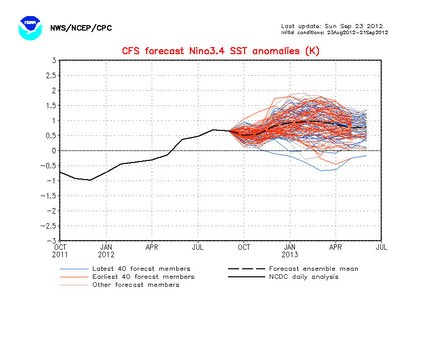
Was working on a presentation for tomorrow and saw that CFS updated this afternoon (images are thumbnailed)
Looks like it brings us to La Nina conditions fairly rapidly

The PDF-corrected version is moderated somewhat, but the 3-month mean is still near La Nina at the peak of the season and beyond -0.5 degrees within the season

http://www.cpc.noaa.gov/products/analys ... cast.shtml
Looks like it brings us to La Nina conditions fairly rapidly

The PDF-corrected version is moderated somewhat, but the 3-month mean is still near La Nina at the peak of the season and beyond -0.5 degrees within the season

http://www.cpc.noaa.gov/products/analys ... cast.shtml
0 likes
-
cycloneye
- Admin
- Posts: 149156
- Age: 69
- Joined: Thu Oct 10, 2002 10:54 am
- Location: San Juan, Puerto Rico
Re: ENSO Updates=BoM 4/28/10=ENSO reaches Neutral threshold
The update of the SOI tonight goes down from +15.7 to + 15.5. The index will go up and down from now on after this big spike upwards. As long it stays positive,El Nino wont make a comeback.
20100328,20100426,15.7
20100329,20100427,15.5
20100328,20100426,15.7
20100329,20100427,15.5
0 likes
Visit the Caribbean-Central America Weather Thread where you can find at first post web cams,radars
and observations from Caribbean basin members Click Here
and observations from Caribbean basin members Click Here
-
cycloneye
- Admin
- Posts: 149156
- Age: 69
- Joined: Thu Oct 10, 2002 10:54 am
- Location: San Juan, Puerto Rico
Re: ENSO Updates
The CFS model continues to drop more colder and colder towards a Weak La Nina by July. I think its a little bit fast to drop all the way down there,but mother nature has its own mind.
http://www.cpc.ncep.noaa.gov/products/a ... cast.shtml
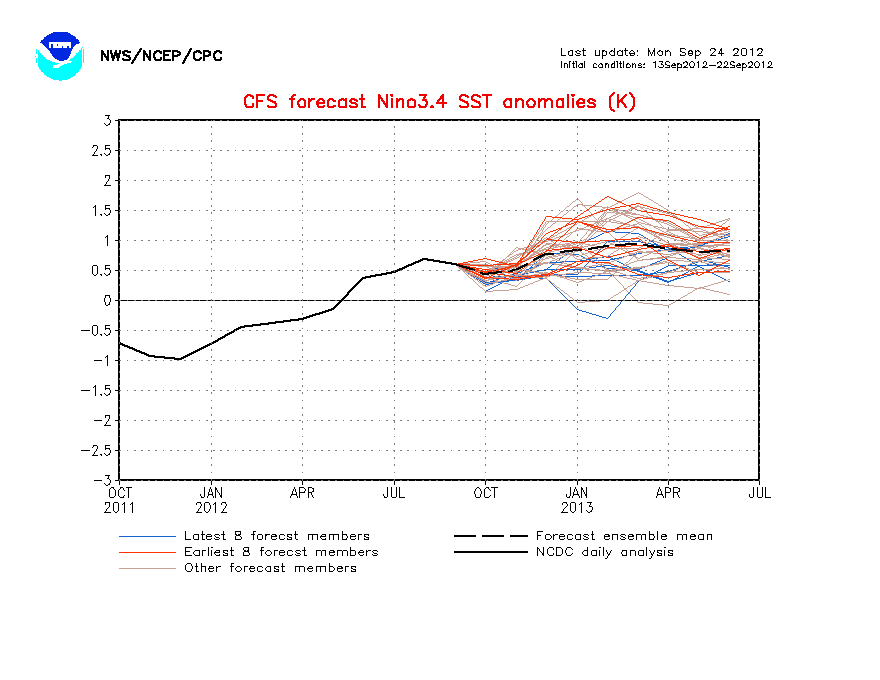
Here are the 40 ensemble members.
http://www.cpc.ncep.noaa.gov/products/a ... cast.shtml
Here are the 40 ensemble members.
0 likes
Visit the Caribbean-Central America Weather Thread where you can find at first post web cams,radars
and observations from Caribbean basin members Click Here
and observations from Caribbean basin members Click Here

Re: ENSO Updates
FMA: +1.5 °C
MAM: +1.0 °C
AMJ: +0.5 °C
MJJ: 0.0 °C
JJA: -0.5°C
JAS: -0.8°C
ASO -1.0°C
0 likes
-
cycloneye
- Admin
- Posts: 149156
- Age: 69
- Joined: Thu Oct 10, 2002 10:54 am
- Location: San Juan, Puerto Rico
Re: ENSO Updates
ENSO models 4/30/10 monthly update
The April update of all of the ENSO models are Neutral to La Nina as time expands.
Models predict neutral conditions to persist over coming months, with the possibility of cool conditions later in the year.
Summary
As detailed in our ENSO Wrap-up, neutral ENSO conditions have effectively returned to the Pacific Ocean.
Dynamical model predictions of Niño3.4 sea surface temperatures indicate that neutral conditions are likely to persist over the coming months. Six of the seven international models surveyed here, indicate that cooler than average temperatures are expected to return to the central Pacific by the middle of this austral winter. Five of those models raise the possibility of La Niña conditions by spring.
http://www.bom.gov.au/climate/ahead/ENSO-summary.shtml
0 likes
Visit the Caribbean-Central America Weather Thread where you can find at first post web cams,radars
and observations from Caribbean basin members Click Here
and observations from Caribbean basin members Click Here
Re: ENSO Updates
Macrocane wrote::uarrow: Well it has happened before, in 1998 the Pacific experienced a big drop in temperatures, look at the anomalies in the 3 months periods of that year:
FMA: +1.5 °C
MAM: +1.0 °C
AMJ: +0.5 °C
MJJ: 0.0 °C
JJA: -0.5°C
JAS: -0.8°C
ASO -1.0°C
True but the La Nina in 1998 was already showing subtle signs of developing strongly, thus far we've seen very few actual signals for anything other then neutral out there. sure the SOI is positive but that IMO isn't nearly enough to suggest any La Nina is developing right now. With 1998 the cold water was very well established already to the south of the El Nino and drifted northwards over the year, here is the image from mid June of the event with already large cooler than average waters present close to the 3.4 zone:
http://outreach.eos.nasa.gov/EOSDIS_CD- ... p49933.gif
Still I see no reason why things won't continue to steadily cool down at least towards cool neutral...
0 likes
Personal Forecast Disclaimer:
The posts in this forum are NOT official forecast and should not be used as such. They are just the opinion of the poster and may or may not be backed by sound meteorological data. They are NOT endorsed by any professional institution or storm2k.org. For official information, please refer to the NHC and NWS products
The posts in this forum are NOT official forecast and should not be used as such. They are just the opinion of the poster and may or may not be backed by sound meteorological data. They are NOT endorsed by any professional institution or storm2k.org. For official information, please refer to the NHC and NWS products
-
cycloneye
- Admin
- Posts: 149156
- Age: 69
- Joined: Thu Oct 10, 2002 10:54 am
- Location: San Juan, Puerto Rico
Re: ENSO Updates
The cooler waters are starting to reach the surface as El Nino 3.4 area is now blue with +0.5C to 0.0C.

0 likes
Visit the Caribbean-Central America Weather Thread where you can find at first post web cams,radars
and observations from Caribbean basin members Click Here
and observations from Caribbean basin members Click Here
-
brunota2003

- S2K Supporter

- Posts: 9476
- Age: 35
- Joined: Sat Jul 30, 2005 9:56 pm
- Location: Stanton, KY...formerly Havelock, NC
- Contact:
Here is my question about this...if we hit La Nina fairly quickly, wouldn't it take a little bit of time for that to translate over in terms of weather conditions in the Atlantic? I mean, the Atlantic is not going to just be like "Oh, I feel like being La Nina today." Much like the pressure in a storm drops, but it takes a bit for the winds to catch up.
0 likes
-
cycloneye
- Admin
- Posts: 149156
- Age: 69
- Joined: Thu Oct 10, 2002 10:54 am
- Location: San Juan, Puerto Rico
Re:
brunota2003 wrote:Here is my question about this...if we hit La Nina fairly quickly, wouldn't it take a little bit of time for that to translate over in terms of weather conditions in the Atlantic? I mean, the Atlantic is not going to just be like "Oh, I feel like being La Nina today." Much like the pressure in a storm drops, but it takes a bit for the winds to catch up.
What I have heard is that there is a lag of time for the atmospheric conditions to catch up to Neutral or La Nina. For example,ENSO is at Neutral from now,it may take a month to get conditions of Neutral.But I may be wrong on this so I better wait for one of our pro mets to tell us the real deal with this.
0 likes
Visit the Caribbean-Central America Weather Thread where you can find at first post web cams,radars
and observations from Caribbean basin members Click Here
and observations from Caribbean basin members Click Here
Who is online
Users browsing this forum: No registered users and 101 guests