EPAC / Caribbean development later this week?
Moderator: S2k Moderators
Forum rules
The posts in this forum are NOT official forecasts and should not be used as such. They are just the opinion of the poster and may or may not be backed by sound meteorological data. They are NOT endorsed by any professional institution or STORM2K. For official information, please refer to products from the National Hurricane Center and National Weather Service.
- cycloneye
- Admin

- Posts: 148737
- Age: 69
- Joined: Thu Oct 10, 2002 10:54 am
- Location: San Juan, Puerto Rico
Re: SW Caribbean development next week?
A kind of summary of the models on the tracks for the Caribbean system minus EURO in this graphic.


0 likes
Visit the Caribbean-Central America Weather Thread where you can find at first post web cams,radars
and observations from Caribbean basin members Click Here
and observations from Caribbean basin members Click Here
- Extremeweatherguy
- Category 5

- Posts: 11095
- Joined: Mon Oct 10, 2005 8:13 pm
- Location: Florida
Re: SW Caribbean development next week?
Very interesting to see all of the models jumping on this possible tropical cyclone next week. Whether or not anything actually ever develops is yet to be seen, but with so much model support it definitely seems to be worth watching. An early season sheared TD or TS forming in the western Caribbean and then heading northward definitely wouldn't be an unheard of occurrence.
0 likes
Without a doubt, in fact both systems that the models develop are possible developmental zones in the early season period hence why both must be watched.
Still this one has the best shot at being a purely tropical feature thats for sure.
Still this one has the best shot at being a purely tropical feature thats for sure.
0 likes
Personal Forecast Disclaimer:
The posts in this forum are NOT official forecast and should not be used as such. They are just the opinion of the poster and may or may not be backed by sound meteorological data. They are NOT endorsed by any professional institution or storm2k.org. For official information, please refer to the NHC and NWS products
The posts in this forum are NOT official forecast and should not be used as such. They are just the opinion of the poster and may or may not be backed by sound meteorological data. They are NOT endorsed by any professional institution or storm2k.org. For official information, please refer to the NHC and NWS products
Re: SW Caribbean development next week?
If this should develop it looks like the models are bringing the moisture and energy from near Panama northward but it might be that, along with the trough near the Eastern Yucatan, drifting eastward. it already shows signs of some 850 mb vorticity can't do anything thankfully because the shear is still way too strong.


0 likes
The following post is NOT an official forecast and should not be used as such. It is just the opinion of the poster and may or may not be backed by sound meteorological data. It is NOT endorsed by any professional institution including storm2k.org For Official Information please refer to the NHC and NWS products.
- HURAKAN
- Professional-Met

- Posts: 46086
- Age: 38
- Joined: Thu May 20, 2004 4:34 pm
- Location: Key West, FL
- Contact:
Panama City reporting 1006 mb.
Link - http://weather.noaa.gov/weather/current/MPTO.html
Pressures are already very low in the Caribbean.
0 likes
- cycloneye
- Admin

- Posts: 148737
- Age: 69
- Joined: Thu Oct 10, 2002 10:54 am
- Location: San Juan, Puerto Rico
Re: SW Caribbean development next week?
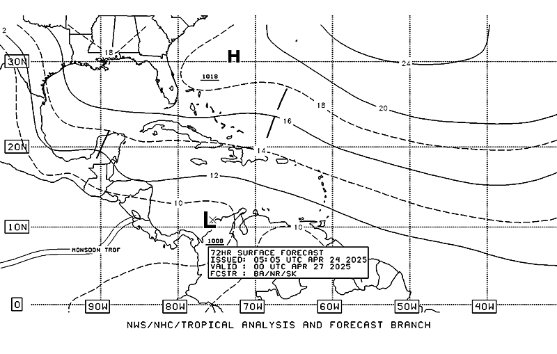
TAFB analysis at 72 hours.


0 likes
Visit the Caribbean-Central America Weather Thread where you can find at first post web cams,radars
and observations from Caribbean basin members Click Here
and observations from Caribbean basin members Click Here
- cycloneye
- Admin

- Posts: 148737
- Age: 69
- Joined: Thu Oct 10, 2002 10:54 am
- Location: San Juan, Puerto Rico
Re: SW Caribbean development next week?
18z NOGAPS at 144 hours
Low going up in intensity.

Low going up in intensity.

0 likes
Visit the Caribbean-Central America Weather Thread where you can find at first post web cams,radars
and observations from Caribbean basin members Click Here
and observations from Caribbean basin members Click Here
- gatorcane
- S2K Supporter

- Posts: 23703
- Age: 47
- Joined: Sun Mar 13, 2005 3:54 pm
- Location: Boca Raton, FL
As for the SW Caribbean development, I'm leaning towards "no" on development at this time. Still calling for an area of convection to develop in the SW Caribbean with weak surface low that gets pull NNE to NE into a large weakness that should form out around 7 days from now. The MJO pulse will move in from the EPAC and spread into the SW Caribbean that will spark this low to form. Main reason is the high shear blowing in from the West that does not appear that it will let up for the 10 days or so. Of course shear projections can be wrong. It's also a bit early for development in this area. In about 4 weeks it will be a different story though...
0 likes
Not so sure about the idea its too early Gatorcane, SST's are above average and whilst its not common, once you get to late May, development in the Caribbean becomes increasingly possible , really the conditions aren't much different between late May and early June.
That being said the models aren't that suggestive despite most suggesting some weak development...remains to be seen what actually occurs!
That being said the models aren't that suggestive despite most suggesting some weak development...remains to be seen what actually occurs!
0 likes
Personal Forecast Disclaimer:
The posts in this forum are NOT official forecast and should not be used as such. They are just the opinion of the poster and may or may not be backed by sound meteorological data. They are NOT endorsed by any professional institution or storm2k.org. For official information, please refer to the NHC and NWS products
The posts in this forum are NOT official forecast and should not be used as such. They are just the opinion of the poster and may or may not be backed by sound meteorological data. They are NOT endorsed by any professional institution or storm2k.org. For official information, please refer to the NHC and NWS products
-
guyclaude08
- Tropical Low

- Posts: 39
- Joined: Thu Sep 24, 2009 8:01 am
Yep the 0z models have somewhat backed off development, then again they weren't really doing much with it in the first place really...
0 likes
Personal Forecast Disclaimer:
The posts in this forum are NOT official forecast and should not be used as such. They are just the opinion of the poster and may or may not be backed by sound meteorological data. They are NOT endorsed by any professional institution or storm2k.org. For official information, please refer to the NHC and NWS products
The posts in this forum are NOT official forecast and should not be used as such. They are just the opinion of the poster and may or may not be backed by sound meteorological data. They are NOT endorsed by any professional institution or storm2k.org. For official information, please refer to the NHC and NWS products
Here's the latest GFS loop - nothing to get in a spin over (lol):
http://weather.unisys.com/gfsx/loop/gfsx_500p_loop.html
http://weather.unisys.com/gfsx/loop/gfsx_500p_loop.html
0 likes
-
tolakram
- Admin

- Posts: 20168
- Age: 62
- Joined: Sun Aug 27, 2006 8:23 pm
- Location: Florence, KY (name is Mark)
Re: SW Caribbean development next week?
epac epac epac epac 
I have no clue of course, but we've seen the blob before.
I have no clue of course, but we've seen the blob before.
0 likes
M a r k
- - - - -
Join us in chat: Storm2K Chatroom Invite. Android and IOS apps also available.
The posts in this forum are NOT official forecasts and should not be used as such. Posts are NOT endorsed by any professional institution or STORM2K.org. For official information and forecasts, please refer to NHC and NWS products.
Who is online
Users browsing this forum: ljmac75 and 91 guests


