ATL : INVEST 90L

Moderator: S2k Moderators

Message
Author
cwachal

Re: Re:

#141 Postby cwachal » Sun May 23, 2010 8:36 pm

Hurricane Andrew wrote:
cwachal wrote:Well I put my forecast for the 2010 hurricane season in my signature here below this post

That is soooo funny!(in a good way!)

Cause my forcast has been for a while as follows...
17-20 NS
8-11 'canes
2-6 MJ


well although I cant prove it since I am new here this has been my forecast since February personally
0 likes   

cwachal

#142 Postby cwachal » Sun May 23, 2010 8:37 pm

Image

looks like it is warm cored for now
0 likes   

cwachal

#143 Postby cwachal » Sun May 23, 2010 9:04 pm

is anyone on?
0 likes   

User avatar
Hurricanehink
S2K Supporter
S2K Supporter
Posts: 2040
Joined: Sun Nov 16, 2003 2:05 pm
Location: New Jersey

Re: ATL : INVEST 90L=CODE ORANGE

#144 Postby Hurricanehink » Sun May 23, 2010 9:21 pm

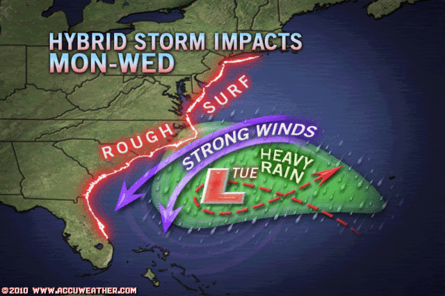
Given how far north it already is, that it's moving north-northwestward, and that a new low is forecast to reform to the north, where is its expected track, and is there much of a threat to the US?
0 likes   

User avatar
HURAKAN
Professional-Met
Professional-Met
Posts: 46086
Age: 38
Joined: Thu May 20, 2004 4:34 pm
Location: Key West, FL
Contact:

#145 Postby HURAKAN » Sun May 23, 2010 9:46 pm

Image

Latest
0 likes   

User avatar
cycloneye
Admin
Admin
Posts: 145285
Age: 68
Joined: Thu Oct 10, 2002 10:54 am
Location: San Juan, Puerto Rico

Re: ATL : INVEST 90L=CODE ORANGE

#146 Postby cycloneye » Sun May 23, 2010 10:15 pm

Image
0 likes   
Visit the Caribbean-Central America Weather Thread where you can find at first post web cams,radars
and observations from Caribbean basin members Click Here

User avatar
AdamFirst
S2K Supporter
S2K Supporter
Posts: 2491
Age: 36
Joined: Thu Aug 14, 2008 10:54 am
Location: Port Saint Lucie, FL

Re:

#147 Postby AdamFirst » Sun May 23, 2010 10:17 pm

cwachal wrote:is anyone on?


Things tend to get dead on here after 10 PM...I have a feeling it will be busy tomorrow though. :lol:
0 likes   
Dolphins Marlins Canes Golden Panthers HEAT
Andrew 1992 - Irene 1999 - Frances 2004 - Jeanne 2004 - Wilma 2005 - Fay 2008 - Isaac 2012 - Matthew 2016 - Irma 2017 - Dorian 2019 - Ian 2022 - Nicole 2022 - Milton 2024

User avatar
HURAKAN
Professional-Met
Professional-Met
Posts: 46086
Age: 38
Joined: Thu May 20, 2004 4:34 pm
Location: Key West, FL
Contact:

#148 Postby HURAKAN » Sun May 23, 2010 11:06 pm

Image

Latest
0 likes   

User avatar
HURAKAN
Professional-Met
Professional-Met
Posts: 46086
Age: 38
Joined: Thu May 20, 2004 4:34 pm
Location: Key West, FL
Contact:

#149 Postby HURAKAN » Sun May 23, 2010 11:08 pm

Image

Accuweather
0 likes   

User avatar
HURAKAN
Professional-Met
Professional-Met
Posts: 46086
Age: 38
Joined: Thu May 20, 2004 4:34 pm
Location: Key West, FL
Contact:

#150 Postby HURAKAN » Sun May 23, 2010 11:17 pm

0 likes   

User avatar
ROCK
Category 5
Category 5
Posts: 9484
Age: 54
Joined: Tue Aug 17, 2004 7:30 am
Location: Kemah, Texas

Re: ATL : INVEST 90L=CODE ORANGE

#151 Postby ROCK » Sun May 23, 2010 11:21 pm

Ivanhater wrote:
jaxfladude wrote:Hope IS NOT AN OMEN of a busy season :flag:


This is and all the other factors...I have not seen 1 negative for this season which is extremely rare


Hey Ivan, another season bro and you are right....this is not going to be a pretty season...JB seems to think so also.
0 likes   

User avatar
LaPlaceFF
Category 5
Category 5
Posts: 1303
Age: 58
Joined: Sat May 29, 2004 1:21 pm
Location: Gramercy, LA
Contact:

#152 Postby LaPlaceFF » Sun May 23, 2010 11:25 pm

What's a code orange?
0 likes   

User avatar
Macrocane
Category 5
Category 5
Posts: 4218
Age: 36
Joined: Sun May 24, 2009 5:35 pm
Location: El Salvador

Re: ATL : INVEST 90L=CODE ORANGE

#153 Postby Macrocane » Sun May 23, 2010 11:30 pm

:uarrow: It´s a code that the NHC use with disturbances and means that a disturbance has a medium chance (between 30% and 50%) of developing into a tropical or subtropical cyclone.
0 likes   

User avatar
HURAKAN
Professional-Met
Professional-Met
Posts: 46086
Age: 38
Joined: Thu May 20, 2004 4:34 pm
Location: Key West, FL
Contact:

Re:

#154 Postby HURAKAN » Sun May 23, 2010 11:33 pm

LaPlaceFF wrote:What's a code orange?


Image
0 likes   

User avatar
HURAKAN
Professional-Met
Professional-Met
Posts: 46086
Age: 38
Joined: Thu May 20, 2004 4:34 pm
Location: Key West, FL
Contact:

#155 Postby HURAKAN » Sun May 23, 2010 11:34 pm

Image

00z
0 likes   

CrazyC83
Professional-Met
Professional-Met
Posts: 34002
Joined: Tue Mar 07, 2006 11:57 pm
Location: Deep South, for the first time!

#156 Postby CrazyC83 » Mon May 24, 2010 12:03 am

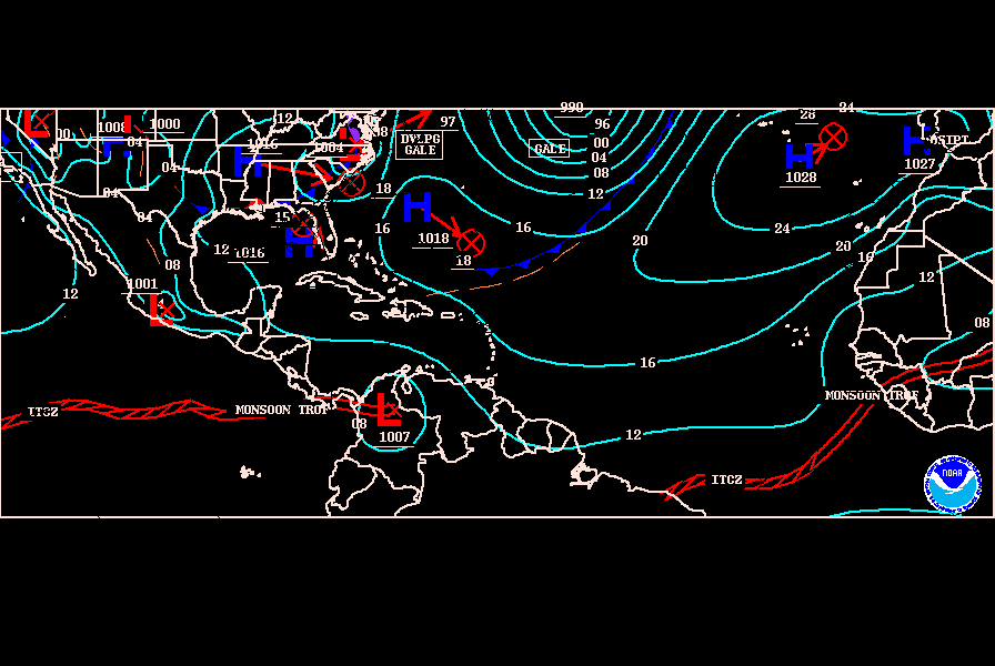
Is the precipitation extending southward a cold front? Or is it non-frontal?
0 likes   

User avatar
Macrocane
Category 5
Category 5
Posts: 4218
Age: 36
Joined: Sun May 24, 2009 5:35 pm
Location: El Salvador

Re: ATL : INVEST 90L=CODE ORANGE

#157 Postby Macrocane » Mon May 24, 2010 12:14 am

According to the surface analysis it is non frontal.
0 likes   

User avatar
Ivanhater
Storm2k Moderator
Storm2k Moderator
Posts: 11160
Age: 38
Joined: Fri Jul 01, 2005 8:25 am
Location: Pensacola

Re: ATL : INVEST 90L=CODE ORANGE

#158 Postby Ivanhater » Mon May 24, 2010 2:35 am

ROCK wrote:
Ivanhater wrote:
jaxfladude wrote:Hope IS NOT AN OMEN of a busy season :flag:


This is and all the other factors...I have not seen 1 negative for this season which is extremely rare


Hey Ivan, another season bro and you are right....this is not going to be a pretty season...JB seems to think so also.


Welcome back buddy! yeah I have a feeling there will be a lot more late nights this season 8-) ...and so it starts
0 likes   
Michael

User avatar
KWT
Category 5
Category 5
Posts: 31415
Joined: Tue Aug 17, 2004 11:02 am
Location: UK!!!

#159 Postby KWT » Mon May 24, 2010 4:25 am

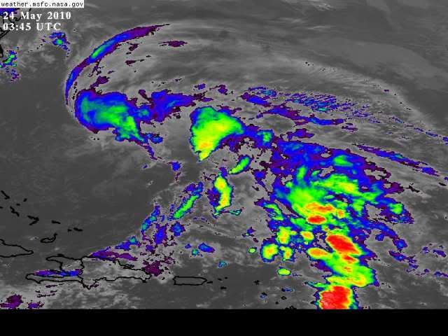
The whole area is just a big mess right now with multiple circulations circulating around a main low and the convection still clearly shearing off from the circulations as they rotate southwards.
0 likes   
Personal Forecast Disclaimer:
The posts in this forum are NOT official forecast and should not be used as such. They are just the opinion of the poster and may or may not be backed by sound meteorological data. They are NOT endorsed by any professional institution or storm2k.org. For official information, please refer to the NHC and NWS products

User avatar
Hurricane Andrew
S2K Supporter
S2K Supporter
Posts: 1891
Age: 26
Joined: Sun May 23, 2010 2:53 pm
Location: KS

#160 Postby Hurricane Andrew » Mon May 24, 2010 5:45 am

The Convection is starting to deepen. By the way, Hi everyone!

It is rotation like wheel.
0 likes   

The Enthusiast
NREMT-AEMT, WX nerd

Irene '11, Sandy '12, Irma '17 (SAR)

"Hard to think we were born to live this way..." -Wage War


Return to “2010”

Who is online

Users browsing this forum: No registered users and 5 guests