BEGIN
NHC_ATCF
invest_ep902010.invest
FSTDA
R
U
040
010
0000
201005251857
NONE
NOTIFY=ATRP
END
INVEST, EP, E, , , , , 90, 2010, DB, O, 2010052518, 9999999999, , , , , , METWATCH, , EP902010
EP, 90, 2010052500, , BEST, 0, 108N, 880W, 20, 1009, DB, 0, , 0, 0, 0, 0,
EP, 90, 2010052506, , BEST, 0, 109N, 883W, 20, 1008, DB, 0, , 0, 0, 0, 0,
EP, 90, 2010052512, , BEST, 0, 110N, 886W, 20, 1007, DB, 0, , 0, 0, 0, 0,
EP, 90, 2010052518, , BEST, 0, 111N, 889W, 20, 1007, DB, 34, NEQ, 0, 0, 0, 0, 1008, 160, 20, 0, 0,
ftp://ftp.tpc.ncep.noaa.gov/atcf/tcweb/
EPAC : EX TROPICAL DEPRESSION AGATHA
Moderator: S2k Moderators
-
cycloneye

- Admin

- Posts: 149585
- Age: 69
- Joined: Thu Oct 10, 2002 10:54 am
- Location: San Juan, Puerto Rico
EPAC : EX TROPICAL DEPRESSION AGATHA
0 likes
Visit the Caribbean-Central America Weather Thread where you can find at first post web cams,radars
and observations from Caribbean basin members Click Here
and observations from Caribbean basin members Click Here
-
srainhoutx

- S2K Supporter

- Posts: 6919
- Age: 68
- Joined: Sun Jan 14, 2007 11:34 am
- Location: Haywood County, NC
- Contact:
Re: EPAC : INVEST 90E
We may very well see Agatha forming. It will be nice to see what the tropical tracking models suggest in regards to 90E.
0 likes
Carla/Alicia/Jerry(In The Eye)/Michelle/Charley/Ivan/Dennis/Katrina/Rita/Wilma/Ike/Harvey
Member: National Weather Association
Wx Infinity Forums
http://wxinfinity.com/index.php
Facebook.com/WeatherInfinity
Twitter @WeatherInfinity
Member: National Weather Association
Wx Infinity Forums
http://wxinfinity.com/index.php
Facebook.com/WeatherInfinity
Twitter @WeatherInfinity
-
Evil Jeremy

- S2K Supporter
- Posts: 5463
- Age: 32
- Joined: Mon Apr 10, 2006 2:10 pm
- Location: Los Angeles, CA
Re: EPAC : INVEST 90E
Now the question is, will something significant be able to form before this system crosses over into the Caribbean, and if so, will it remain together over its land travel.
0 likes
Frances 04 / Jeanne 04 / Katrina 05 / Wilma 05 / Fay 08 / Debby 12 / Andrea 13 / Colin 16 / Hermine 16 / Matthew 16 / Irma 17
-
Category 5

- Category 5

- Posts: 10074
- Age: 36
- Joined: Sun Feb 11, 2007 10:00 pm
- Location: New Brunswick, NJ
- Contact:
Re: EPAC : INVEST 90E
That is to be seen, depends how in tact it is when it moves back over water. If it holds its core (or at least keeps it in tact) it may very well be a double storm.
0 likes
-
cycloneye
- Admin
- Posts: 149585
- Age: 69
- Joined: Thu Oct 10, 2002 10:54 am
- Location: San Juan, Puerto Rico
Re: EPAC : INVEST 90E
First model run by the tropical models has it at 64kts at maximun before it makes landfall.
WHXX01 KMIA 251859
CHGE77
TROPICAL CYCLONE GUIDANCE MESSAGE
NWS TPC/NATIONAL HURRICANE CENTER MIAMI FL
1859 UTC TUE MAY 25 2010
DISCLAIMER...NUMERICAL MODELS ARE SUBJECT TO LARGE ERRORS.
PLEASE REFER TO NHC OFFICIAL FORECASTS FOR TROPICAL CYCLONE
AND SUBTROPICAL CYCLONE INFORMATION.
EAST PACIFIC OBJECTIVE AIDS FOR
DISTURBANCE INVEST (EP902010) 20100525 1800 UTC
...00 HRS... ...12 HRS... ...24 HRS. .. ...36 HRS...
100525 1800 100526 0600 100526 1800 100527 0600
LAT LON LAT LON LAT LON LAT LON
BAMS 11.1N 88.9W 11.7N 89.4W 12.7N 90.2W 13.6N 91.3W
BAMD 11.1N 88.9W 11.0N 89.6W 11.4N 90.4W 12.1N 91.4W
BAMM 11.1N 88.9W 11.3N 89.6W 11.8N 90.3W 12.5N 91.1W
LBAR 11.1N 88.9W 11.4N 89.2W 12.2N 89.9W 13.5N 90.6W
SHIP 20KTS 27KTS 40KTS 55KTS
DSHP 20KTS 27KTS 40KTS 55KTS
...48 HRS... ...72 HRS... ...96 HRS. .. ..120 HRS...
100527 1800 100528 1800 100529 1800 100530 1800
LAT LON LAT LON LAT LON LAT LON
BAMS 14.1N 92.1W 15.3N 92.4W 16.0N 89.1W 18.3N 84.2W
BAMD 13.1N 92.5W 14.8N 93.9W 15.9N 92.7W 17.4N 89.6W
BAMM 13.3N 92.0W 15.1N 92.2W 17.0N 87.9W 20.5N 80.6W
LBAR 14.8N 90.8W 17.0N 89.2W 18.3N 83.5W 21.8N 74.8W
SHIP 63KTS 64KTS 59KTS 58KTS
DSHP 63KTS 48KTS 32KTS 31KTS
...INITIAL CONDITIONS...
LATCUR = 11.1N LONCUR = 88.9W DIRCUR = 290DEG SPDCUR = 3KT
LATM12 = 10.9N LONM12 = 88.3W DIRM12 = 289DEG SPDM12 = 3KT
LATM24 = 10.6N LONM24 = 87.4W
WNDCUR = 20KT RMAXWD = 20NM WNDM12 = 20KT
CENPRS = 1007MB OUTPRS = 1008MB OUTRAD = 160NM SDEPTH = D
RD34NE = 0NM RD34SE = 0NM RD34SW = 0NM RD34NW = 0NM
0 likes
Visit the Caribbean-Central America Weather Thread where you can find at first post web cams,radars
and observations from Caribbean basin members Click Here
and observations from Caribbean basin members Click Here

I think this probably will become a TS, possibly even come close to a hurricaxne before it recurves towards Mexico.
As for the future b eyond that possible future landfall, the risk the enerrgy makes it to the Caribbean is certainly there IMO, but much depends on how quickly it recurves, the GFDL does have something of a right bias at times with these sorts of systems that haven't yet developed.
As for the future b eyond that possible future landfall, the risk the enerrgy makes it to the Caribbean is certainly there IMO, but much depends on how quickly it recurves, the GFDL does have something of a right bias at times with these sorts of systems that haven't yet developed.
0 likes
Personal Forecast Disclaimer:
The posts in this forum are NOT official forecast and should not be used as such. They are just the opinion of the poster and may or may not be backed by sound meteorological data. They are NOT endorsed by any professional institution or storm2k.org. For official information, please refer to the NHC and NWS products
The posts in this forum are NOT official forecast and should not be used as such. They are just the opinion of the poster and may or may not be backed by sound meteorological data. They are NOT endorsed by any professional institution or storm2k.org. For official information, please refer to the NHC and NWS products

Re: EPAC : INVEST 90E
The Euro does not show anything in the last run, I don't know what's happening to it but in the last few weeks it has not been as consistent as it was used to:
Euro 48 hours
Euro 48 hours
0 likes
Worth noting the 12z ECM ensembles do show something though given we can only see the mean it shows up as a weak featuyre, but the fact the ensembles do show something at all suggests the 12z ECM probably just didn't do a good job on it, esp given most other models are keen...
Still early days yet with this system, will be interesting to see what the 18z models suggests.
I do like the general idea of the models going W/WNW then eventually lift N/NNE and recurve towards Mexico.
Still early days yet with this system, will be interesting to see what the 18z models suggests.
I do like the general idea of the models going W/WNW then eventually lift N/NNE and recurve towards Mexico.
0 likes
Personal Forecast Disclaimer:
The posts in this forum are NOT official forecast and should not be used as such. They are just the opinion of the poster and may or may not be backed by sound meteorological data. They are NOT endorsed by any professional institution or storm2k.org. For official information, please refer to the NHC and NWS products
The posts in this forum are NOT official forecast and should not be used as such. They are just the opinion of the poster and may or may not be backed by sound meteorological data. They are NOT endorsed by any professional institution or storm2k.org. For official information, please refer to the NHC and NWS products
-
cycloneye
- Admin
- Posts: 149585
- Age: 69
- Joined: Thu Oct 10, 2002 10:54 am
- Location: San Juan, Puerto Rico
Re: EPAC : INVEST 90E
0 likes
Visit the Caribbean-Central America Weather Thread where you can find at first post web cams,radars
and observations from Caribbean basin members Click Here
and observations from Caribbean basin members Click Here
-
Hurricane Andrew

- S2K Supporter
- Posts: 1891
- Age: 27
- Joined: Sun May 23, 2010 2:53 pm
- Location: KS
-
somethingfunny

- ChatStaff

- Posts: 3926
- Age: 37
- Joined: Thu May 31, 2007 10:30 pm
- Location: McKinney, Texas
Re: EPAC : INVEST 90E
90E is looking good. I'm not sold on its' durability on the Atlantic side, though. Crossovers are rare and the farther north it makes landfall the more landmass it will have to traverse.
Time to go find the BAMS/BAMM/BAMD model suite, or as I like to call it, the Bible of Cyclone Potential.
Time to go find the BAMS/BAMM/BAMD model suite, or as I like to call it, the Bible of Cyclone Potential.
0 likes
-
cycloneye
- Admin
- Posts: 149585
- Age: 69
- Joined: Thu Oct 10, 2002 10:54 am
- Location: San Juan, Puerto Rico
Re: EPAC : INVEST 90E
somethingfunny wrote:90E is looking good. I'm not sold on its' durability on the Atlantic side, though. Crossovers are rare and the farther north it makes landfall the more landmass it will have to traverse.
Time to go find the BAMS/BAMM/BAMD model suite, or as I like to call it, the Bible of Cyclone Potential.
Is 6 posts above your post.
0 likes
Visit the Caribbean-Central America Weather Thread where you can find at first post web cams,radars
and observations from Caribbean basin members Click Here
and observations from Caribbean basin members Click Here
-
cycloneye
- Admin
- Posts: 149585
- Age: 69
- Joined: Thu Oct 10, 2002 10:54 am
- Location: San Juan, Puerto Rico
Re: EPAC : INVEST 90E
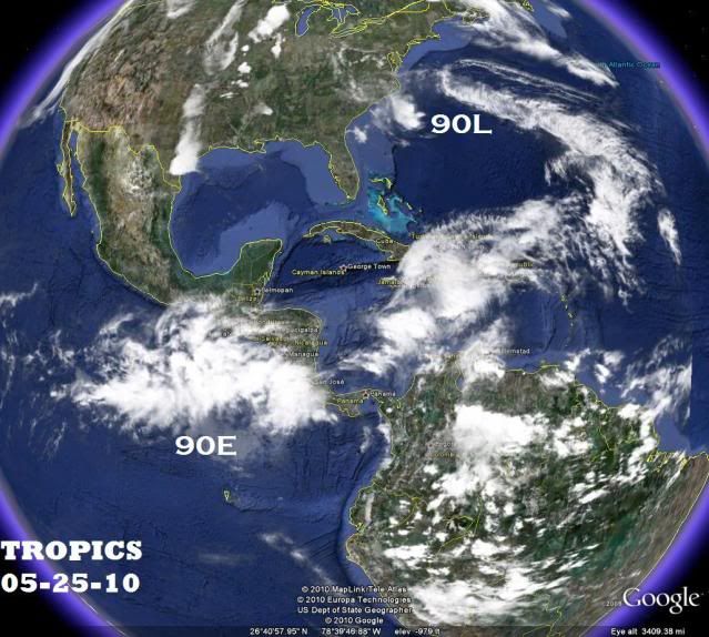
The latest image.Is still not very well organized as it's in the early stage.

0 likes
Visit the Caribbean-Central America Weather Thread where you can find at first post web cams,radars
and observations from Caribbean basin members Click Here
and observations from Caribbean basin members Click Here
-
Hurricane Andrew
- S2K Supporter
- Posts: 1891
- Age: 27
- Joined: Sun May 23, 2010 2:53 pm
- Location: KS


-
somethingfunny
- ChatStaff
- Posts: 3926
- Age: 37
- Joined: Thu May 31, 2007 10:30 pm
- Location: McKinney, Texas
Re: EPAC : INVEST 90E
cycloneye wrote:somethingfunny wrote:90E is looking good. I'm not sold on its' durability on the Atlantic side, though. Crossovers are rare and the farther north it makes landfall the more landmass it will have to traverse.
Time to go find the BAMS/BAMM/BAMD model suite, or as I like to call it, the Bible of Cyclone Potential.
Is 6 posts above your post.
Found it! Thank you sir!
As a general FYI, the policy was changed recently so crossover storms keep the same name instead of getting renamed. No more Cesar-Douglas or Joan-Miriam. You may see on Wikipedia that Alma became Arthur, but Wikipedia is wrong. Alma's remnants combined with another tropical wave to become Arthur. From what I understand, if 90E develops, hits land, and survives to the Atlantic side as a coherent system, it would remain Agatha.
0 likes


-
cycloneye
- Admin
- Posts: 149585
- Age: 69
- Joined: Thu Oct 10, 2002 10:54 am
- Location: San Juan, Puerto Rico
Re: EPAC : INVEST 90E
Marcocane,is directly South from where you are.
TROPICAL WEATHER OUTLOOK
NWS TPC/NATIONAL HURRICANE CENTER MIAMI FL
500 PM PDT TUE MAY 25 2010
FOR THE EASTERN NORTH PACIFIC...EAST OF 140 DEGREES WEST LONGITUDE..
A LARGE AREA OF DISTURBED WEATHER IS CENTERED ABOUT 285 MILES SOUTH
OF EL SALVADOR IN CENTRAL AMERICA. ALTHOUGH THIS AREA IS CURRENTLY
DISORGANIZED...ENVIRONMENTAL CONDITIONS APPEAR TO BE FAVORABLE FOR
SOME DEVELOPMENT AS THE DISTURBANCE DRIFTS TOWARD THE NORTHWEST
DURING THE NEXT DAY OR TWO. THIS SYSTEM HAS THE POTENTIAL TO
PRODUCE LOCALLY HEAVY RAINS AND FLOODING OVER PORTIONS OF CENTRAL
AMERICA DURING THE NEXT FEW DAYS. THERE IS A MEDIUM CHANCE...30
PERCENT...OF THIS SYSTEM BECOMING A TROPICAL CYCLONE DURING THE
NEXT 48 HOURS.
ELSEWHERE...TROPICAL CYCLONE FORMATION IS NOT EXPECTED DURING THE
NEXT 48 HOURS.
$$
FORECASTER AVILA
0 likes
Visit the Caribbean-Central America Weather Thread where you can find at first post web cams,radars
and observations from Caribbean basin members Click Here
and observations from Caribbean basin members Click Here
Who is online
Users browsing this forum: No registered users and 41 guests