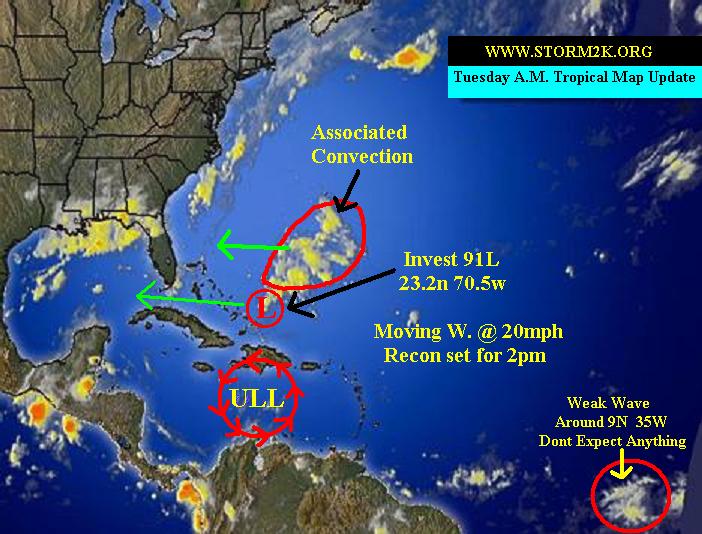
Storm2k Tropical Map Update!!!
Moderator: S2k Moderators
Forum rules

The posts in this forum are NOT official forecasts and should not be used as such. They are just the opinion of the poster and may or may not be backed by sound meteorological data. They are NOT endorsed by any professional institution or STORM2K. For official information, please refer to products from the National Hurricane Center and National Weather Service.

Dry Air Alert
Check out the dry air surrounding 91L on the SE and SW quadrants. May inhibit development.
http://www.ssd.noaa.gov/PS/TROP/DATA/RT/FLOAT/WV/20.jpg
http://www.ssd.noaa.gov/PS/TROP/DATA/RT/FLOAT/WV/20.jpg
0 likes
-
Guest

-
ColdFront77
-
chadtm80
000
ABNT20 KNHC 121459
TWOAT
TROPICAL WEATHER OUTLOOK
NWS TPC/NATIONAL HURRICANE CENTER MIAMI FL
1130 AM EDT TUE AUG 12 2003
FOR THE NORTH ATLANTIC...CARIBBEAN SEA AND THE GULF OF MEXICO...
SATELLITE IMAGES INDICATE THAT THE AREA OF LOW PRESSURE CENTERED
ABOUT ABOUT 585 MILES EAST-SOUTHEAST OF MIAMI FLORIDA IS GRADUALLY
BECOMING BETTER ORGANIZED. SURFACE PRESSURES ARE FALLING AND THERE
HAS BEEN AN INCREASE IN THE SHOWER ACTIVITY SUGGESTING THAT A
TROPICAL DEPRESSION MAY BE FORMING. EVEN IF THE SYSTEM DOES NOT
BECOME A TROPICAL CYCLONE...IT WILL BRING SHOWERS AND GUSTY WINDS
TO PORTIONS OF THE BAHAMAS...SOUTH FLORIDA AND THE FLORIDA KEYS
DURING THE NEXT DAY OR TWO. ALL INTERESTS IN THIS AREA SHOULD
MONITOR THE PROGRESS OF THIS SYSTEM. A RECONNAISSANCE PLANE IS
SCHEDULED TO BE IN THE AREA THIS AFTERNOON TO DETERMINE IF A
TROPICAL CYCLONE HAS FORMED.
A BAND OF SHOWERS OVER THE NORTHWESTERN GULF OF MEXICO IS ASSOCIATED
WITH A BROAD AREA OF LOW PRESSURE. THERE ARE NO SIGNS OF TROPICAL
CYCLONE FORMATION.
ELSEWHERE...TROPICAL STORM FORMATION IS NOT EXPECTED THROUGH
WEDNESDAY.
FORECASTER AVILA
0 likes
Who is online
Users browsing this forum: TheAustinMan and 112 guests