ATL : TROPICAL DEPRESSION TWO - MODELS

Moderator: S2k Moderators

Message
Author
User avatar
Texas Snowman
Storm2k Moderator
Storm2k Moderator
Posts: 6151
Joined: Fri Jan 25, 2008 11:29 am
Location: Denison, Texas

Re: Re:

#61 Postby Texas Snowman » Sun Jul 04, 2010 8:29 pm

Ivanhater wrote:
KWT wrote:Those models suggest Texas, then again those same models pointed to Texas with Alex as well...much is going to depend on where any center forms, because obviously a little to the NE and a similar track to Alex would bring it close if not into Texas...


Agree, but unlike with Alex the steering flow for the next couple of days is NNW not west across the Yucatan


Yep. From where I'm sitting, this one has Texas written all over it, more so than Alex did. I'd say - unofficially of course - that Corpus had better watch out.

BTW, Happy 4th to everyone! :flag:
0 likes   
The above post and any post by Texas Snowman is NOT an official forecast and should not be used as such. It is just the opinion of the poster and may or may not be backed by sound meteorological data. It is NOT endorsed by any professional institution including storm2k.org. For official information, please refer to NWS products.

rockyman
Category 5
Category 5
Posts: 1967
Joined: Thu Jun 26, 2003 12:24 pm
Location: Dauphin Island, AL

#62 Postby rockyman » Sun Jul 04, 2010 9:03 pm

18z (regional) CMC shows system shooting up toward Mobile Bay in 48 hours:

Image

Loop here:
http://www.weatheroffice.gc.ca/model_fo ... 12_....jpg
0 likes   

User avatar
ROCK
Category 5
Category 5
Posts: 9483
Age: 54
Joined: Tue Aug 17, 2004 7:30 am
Location: Kemah, Texas

Re:

#63 Postby ROCK » Sun Jul 04, 2010 9:10 pm

rockyman wrote:18z (regional) CMC shows system shooting up toward Mobile Bay in 48 hours:

Image

Loop here:
http://www.weatheroffice.gc.ca/model_fo ... 12_....jpg


I never knew the CMC ran at 18z...that would be worst case scenario for the oil spill....
0 likes   

rockyman
Category 5
Category 5
Posts: 1967
Joined: Thu Jun 26, 2003 12:24 pm
Location: Dauphin Island, AL

Re: Re:

#64 Postby rockyman » Sun Jul 04, 2010 9:11 pm

ROCK wrote:
rockyman wrote:18z (regional) CMC shows system shooting up toward Mobile Bay in 48 hours:

Image

Loop here:
http://www.weatheroffice.gc.ca/model_fo ... 12_....jpg


I never knew the CMC ran at 18z...that would be worst case scenario for the oil spill....


Only the regional CMC runs at 6 and 18z...mainly focusing on Canada...but it does show the northern part of the Gomex...Would any pros like to weigh in on the value/reliability of these intermediate runs?
0 likes   

Air Force Met
Military Met
Military Met
Posts: 4372
Age: 56
Joined: Tue Jul 08, 2003 9:30 am
Location: Roan Mountain, TN

Re: ATL : INVEST 96L - MODELS

#65 Postby Air Force Met » Sun Jul 04, 2010 9:29 pm

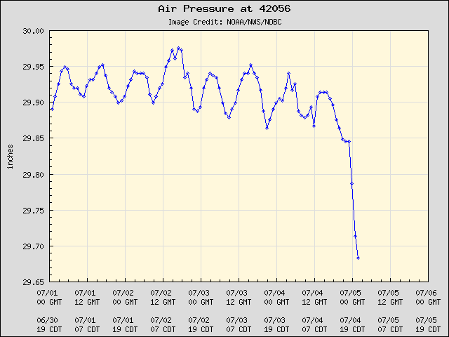
What I want to know is what's going on with the buoy in the NW Caribbean...

Image

Ooopsss...wrong thread...
0 likes   

User avatar
wxman22
Category 5
Category 5
Posts: 1331
Joined: Mon Jan 30, 2006 12:39 am
Location: Wichita Falls, TX
Contact:

#66 Postby wxman22 » Sun Jul 04, 2010 10:34 pm

Again FWIW ofcourse the 0z NAM is basically identical to the 18z

Image
0 likes   

rockyman
Category 5
Category 5
Posts: 1967
Joined: Thu Jun 26, 2003 12:24 pm
Location: Dauphin Island, AL

#67 Postby rockyman » Sun Jul 04, 2010 10:37 pm

0z regional CMC (global not out yet):

Image
0 likes   

rockyman
Category 5
Category 5
Posts: 1967
Joined: Thu Jun 26, 2003 12:24 pm
Location: Dauphin Island, AL

#68 Postby rockyman » Sun Jul 04, 2010 10:39 pm

00z GFS running
0 likes   

rockyman
Category 5
Category 5
Posts: 1967
Joined: Thu Jun 26, 2003 12:24 pm
Location: Dauphin Island, AL

#69 Postby rockyman » Sun Jul 04, 2010 10:42 pm

42 hours:
Image
0 likes   

User avatar
ROCK
Category 5
Category 5
Posts: 9483
Age: 54
Joined: Tue Aug 17, 2004 7:30 am
Location: Kemah, Texas

Re: ATL : INVEST 96L - MODELS

#70 Postby ROCK » Sun Jul 04, 2010 10:43 pm

42 hrs what is that around LA, AL....must be 95L.....96 no where to be seen...
0 likes   

rockyman
Category 5
Category 5
Posts: 1967
Joined: Thu Jun 26, 2003 12:24 pm
Location: Dauphin Island, AL

Re: ATL : INVEST 96L - MODELS

#71 Postby rockyman » Sun Jul 04, 2010 10:44 pm

ROCK wrote:42 hrs what is that around LA, AL....must be 95L.....96 no where to be seen...


I think that's 96L...very similar to the CMC's regional run...showing 96L shooting up out of the Caribbean toward the North Central Gomex
0 likes   

User avatar
Ivanhater
Storm2k Moderator
Storm2k Moderator
Posts: 11153
Age: 38
Joined: Fri Jul 01, 2005 8:25 am
Location: Pensacola

Re: ATL : INVEST 96L - MODELS

#72 Postby Ivanhater » Sun Jul 04, 2010 10:46 pm

ROCK wrote:42 hrs what is that around LA, AL....must be 95L.....96 no where to be seen...


It looks to draw up the moisture from 96L to the NNW with the low level steering flow currently in place..similar to the 18z gfdl
0 likes   
Michael

User avatar
ROCK
Category 5
Category 5
Posts: 9483
Age: 54
Joined: Tue Aug 17, 2004 7:30 am
Location: Kemah, Texas

Re: ATL : INVEST 96L - MODELS

#73 Postby ROCK » Sun Jul 04, 2010 10:46 pm

rockyman wrote:
ROCK wrote:42 hrs what is that around LA, AL....must be 95L.....96 no where to be seen...


I think that's 96L


in 42 hours? no way that is less than 2 days...
0 likes   

User avatar
ROCK
Category 5
Category 5
Posts: 9483
Age: 54
Joined: Tue Aug 17, 2004 7:30 am
Location: Kemah, Texas

Re: ATL : INVEST 96L - MODELS

#74 Postby ROCK » Sun Jul 04, 2010 10:47 pm

Ivanhater wrote:
ROCK wrote:42 hrs what is that around LA, AL....must be 95L.....96 no where to be seen...


It looks to draw up the moisture from 96L to the NNW with the low level steering flow currently in place..similar to the 18z gfdl


Ivan, that is less than 2 days...that cant be 96L unless its moving at 50MPH..... :lol:
0 likes   

rockyman
Category 5
Category 5
Posts: 1967
Joined: Thu Jun 26, 2003 12:24 pm
Location: Dauphin Island, AL

#75 Postby rockyman » Sun Jul 04, 2010 10:48 pm

that's definitely 96L, look at this vorticity loop:

http://www.nco.ncep.noaa.gov/pmb/nwprod ... loop.shtml
0 likes   

User avatar
ROCK
Category 5
Category 5
Posts: 9483
Age: 54
Joined: Tue Aug 17, 2004 7:30 am
Location: Kemah, Texas

Re: ATL : INVEST 96L - MODELS

#76 Postby ROCK » Sun Jul 04, 2010 10:51 pm

ok then....if you guys say so...I still thought 96 was days away not 42 hrs...
0 likes   

rockyman
Category 5
Category 5
Posts: 1967
Joined: Thu Jun 26, 2003 12:24 pm
Location: Dauphin Island, AL

#77 Postby rockyman » Sun Jul 04, 2010 10:51 pm

if it trucks along at 20 mph, it could make that distance in 2 days.
0 likes   

redfish1
Tropical Storm
Tropical Storm
Posts: 125
Age: 44
Joined: Thu Jun 17, 2010 9:24 pm
Location: Port Arthur, Tx

Re: ATL : INVEST 96L - MODELS

#78 Postby redfish1 » Sun Jul 04, 2010 10:53 pm

where is final landfall?
0 likes   

Weatherfreak000

Re: ATL : INVEST 96L - MODELS

#79 Postby Weatherfreak000 » Sun Jul 04, 2010 10:53 pm

Ugh...that GFS run was straight up garbage.

I might be EURO huggin' tonight.
0 likes   

rockyman
Category 5
Category 5
Posts: 1967
Joined: Thu Jun 26, 2003 12:24 pm
Location: Dauphin Island, AL

Re: ATL : INVEST 96L - MODELS

#80 Postby rockyman » Sun Jul 04, 2010 10:54 pm

redfish1 wrote:where is final landfall?


The system falls apart before making landfall, then the energy spreads northward toward the LA/MS/AL/FL area
0 likes   


Return to “2010”

Who is online

Users browsing this forum: No registered users and 23 guests