ATL: EX-Tropical Depression FIVE - Discussion
Moderator: S2k Moderators
-
Aric Dunn
- Category 5

- Posts: 21238
- Age: 43
- Joined: Sun Sep 19, 2004 9:58 pm
- Location: Ready for the Chase.
- Contact:
Well the Mid level and ill defined LLC are nearly stacked... we should see a increasingly organized system over the next 6 hours as this occurs. radar is going to great to watch tonight...
0 likes
Note: If I make a post that is brief. Please refer back to previous posts for the analysis or reasoning. I do not re-write/qoute what my initial post said each time.
If there is nothing before... then just ask
Space & Atmospheric Physicist, Embry-Riddle Aeronautical University,
I believe the sky is falling...
If there is nothing before... then just ask
Space & Atmospheric Physicist, Embry-Riddle Aeronautical University,
I believe the sky is falling...
-
Wx_Warrior
- Category 5
- Posts: 2718
- Joined: Thu Aug 03, 2006 3:58 pm
- Location: Beaumont, TX
-
kevin
Re: ATL: INVEST 94L - Discussion
Whats this about six knots of wind? Surely the hurricane hunters have found higher figures than that..
0 likes

Its looking like a proper developing system, recon shows its probably not quite there just yet but my gosh it must be pretty close by now, the Vis presentation is looking very neat now.
0 likes
Personal Forecast Disclaimer:
The posts in this forum are NOT official forecast and should not be used as such. They are just the opinion of the poster and may or may not be backed by sound meteorological data. They are NOT endorsed by any professional institution or storm2k.org. For official information, please refer to the NHC and NWS products
The posts in this forum are NOT official forecast and should not be used as such. They are just the opinion of the poster and may or may not be backed by sound meteorological data. They are NOT endorsed by any professional institution or storm2k.org. For official information, please refer to the NHC and NWS products

Re:
Aric Dunn wrote:Well the Mid level and ill defined LLC are nearly stacked... we should see a increasingly organized system over the next 6 hours as this occurs. radar is going to great to watch tonight...
Almost there AD probably in a few hours, I'll say A TD at 7pm CST.
0 likes
The following post is NOT an official forecast and should not be used as such. It is just the opinion of the poster and may or may not be backed by sound meteorological data. It is NOT endorsed by any professional institution including storm2k.org For Official Information please refer to the NHC and NWS products.
-
Air Force Met
- Military Met

- Posts: 4372
- Age: 57
- Joined: Tue Jul 08, 2003 9:30 am
- Location: Roan Mountain, TN
Re: Re:
tailgater wrote:Aric Dunn wrote:Well the Mid level and ill defined LLC are nearly stacked... we should see a increasingly organized system over the next 6 hours as this occurs. radar is going to great to watch tonight...
Almost there AD probably in a few hours, I'll say A TD at 7pm CST.
If they didn't upgrade it at 4...they aren't going to do a special at 7. If it has a convective bomb go off between now and 10...then they may upgrade...if not...I doubt we will see an upgrade until tmorrow.
0 likes
Re: Re:
Aric Dunn wrote:
well Im beginning to wonder if we are going to see some significant strengthening tomorrow. The ULL is positioning itself in a very prime location and the outflow over the systems is becoming very symmetric and expansive this afternoon. I think once it establishes a well defined LLC we could see it reach 50 or 60 pretty quickly and I want to bring the chances to hurricane up a little given the synoptic's at the moment.
Yeah I think we will see a strengthening system tomorrow, whilst I'm not sure it'll get up to that strength quite that quickly, the system is looking good and I think we will have a TD in the next 6-12hrs.
0 likes
Personal Forecast Disclaimer:
The posts in this forum are NOT official forecast and should not be used as such. They are just the opinion of the poster and may or may not be backed by sound meteorological data. They are NOT endorsed by any professional institution or storm2k.org. For official information, please refer to the NHC and NWS products
The posts in this forum are NOT official forecast and should not be used as such. They are just the opinion of the poster and may or may not be backed by sound meteorological data. They are NOT endorsed by any professional institution or storm2k.org. For official information, please refer to the NHC and NWS products
-
KFDM Meteorologist

- Professional-Met

- Posts: 1314
- Joined: Tue May 16, 2006 9:52 pm
- Location: Upper Texas Coast/Orange County
-
Ivanhater

- Storm2k Moderator

- Posts: 11221
- Age: 39
- Joined: Fri Jul 01, 2005 8:25 am
- Location: Pensacola
Re: ATL: INVEST 94L - Discussion
I'm wondering if this has enough time to really get stacked. GFS and Euro, even Canadian don't really have this organizing that much.
0 likes
Michael
-
KFDM Meteorologist
- Professional-Met
- Posts: 1314
- Joined: Tue May 16, 2006 9:52 pm
- Location: Upper Texas Coast/Orange County
-
ConvergenceZone
.gif)
- Category 5
- Posts: 5241
- Joined: Fri Jul 29, 2005 1:40 am
- Location: Northern California
-
cycloneye

- Admin

- Posts: 149601
- Age: 69
- Joined: Thu Oct 10, 2002 10:54 am
- Location: San Juan, Puerto Rico
Re: ATL: INVEST 94L - Discussion
Updated 18z Best Track
AL, 94, 2010081018, , BEST, 0, 257N, 839W, 25, 1009, LO
ftp://ftp.tpc.ncep.noaa.gov/atcf/tcweb/ ... 010.invest
AL, 94, 2010081018, , BEST, 0, 257N, 839W, 25, 1009, LO
ftp://ftp.tpc.ncep.noaa.gov/atcf/tcweb/ ... 010.invest
0 likes
Visit the Caribbean-Central America Weather Thread where you can find at first post web cams,radars
and observations from Caribbean basin members Click Here
and observations from Caribbean basin members Click Here
-
mvtrucking

- S2K Supporter

- Posts: 698
- Age: 67
- Joined: Sat Jul 09, 2005 10:01 am
- Location: Monroe,La
Re:
KFDM Meteorologist wrote:May not have time Ivan.
Maybe just a nice rainmaker with a stiff breeze..
0 likes
-
KFDM Meteorologist
- Professional-Met
- Posts: 1314
- Joined: Tue May 16, 2006 9:52 pm
- Location: Upper Texas Coast/Orange County
Re: ATL: INVEST 94L - Discussion
Blowing and raining here. The bushes and palms are really shaking.
The satellite presentation and radar are telling you all you need to know. This has snapped together and pushed back against the ULL and developed. Should be something to watch over the next day.
The satellite presentation and radar are telling you all you need to know. This has snapped together and pushed back against the ULL and developed. Should be something to watch over the next day.
0 likes
Re: ATL: INVEST 94L - Discussion
Ivanhater wrote:I'm wondering if this has enough time to really get stacked. GFS and Euro, even Canadian don't really have this organizing that much.
The models also didn't do much with Felix...and that obviously became a category-5...sometimes the models just can't see what is going ahead in front of them!
0 likes
Personal Forecast Disclaimer:
The posts in this forum are NOT official forecast and should not be used as such. They are just the opinion of the poster and may or may not be backed by sound meteorological data. They are NOT endorsed by any professional institution or storm2k.org. For official information, please refer to the NHC and NWS products
The posts in this forum are NOT official forecast and should not be used as such. They are just the opinion of the poster and may or may not be backed by sound meteorological data. They are NOT endorsed by any professional institution or storm2k.org. For official information, please refer to the NHC and NWS products
-
KFDM Meteorologist
- Professional-Met
- Posts: 1314
- Joined: Tue May 16, 2006 9:52 pm
- Location: Upper Texas Coast/Orange County
Hmmm yeah but not to that big of a degree, and the MLC looks pretty potent right now, I remember last time we had that, we had Alex form the next day, hekc with Alex the systems MLC/LLC were like 300 miles apart yet they came together in about the space of 6-9hrs once conditions improve...
0 likes
Personal Forecast Disclaimer:
The posts in this forum are NOT official forecast and should not be used as such. They are just the opinion of the poster and may or may not be backed by sound meteorological data. They are NOT endorsed by any professional institution or storm2k.org. For official information, please refer to the NHC and NWS products
The posts in this forum are NOT official forecast and should not be used as such. They are just the opinion of the poster and may or may not be backed by sound meteorological data. They are NOT endorsed by any professional institution or storm2k.org. For official information, please refer to the NHC and NWS products
-
srainhoutx

- S2K Supporter
- Posts: 6919
- Age: 68
- Joined: Sun Jan 14, 2007 11:34 am
- Location: Haywood County, NC
- Contact:
Re: ATL: INVEST 94L - Discussion
cycloneye wrote:Updated 18z Best Track
AL, 94, 2010081018, , BEST, 0, 257N, 839W, 25, 1009, LO
ftp://ftp.tpc.ncep.noaa.gov/atcf/tcweb/ ... 010.invest
Slight adjustment SW.
0 likes
Carla/Alicia/Jerry(In The Eye)/Michelle/Charley/Ivan/Dennis/Katrina/Rita/Wilma/Ike/Harvey
Member: National Weather Association
Wx Infinity Forums
http://wxinfinity.com/index.php
Facebook.com/WeatherInfinity
Twitter @WeatherInfinity
Member: National Weather Association
Wx Infinity Forums
http://wxinfinity.com/index.php
Facebook.com/WeatherInfinity
Twitter @WeatherInfinity
-
ozonepete
- Professional-Met
- Posts: 4743
- Joined: Mon Sep 07, 2009 3:23 pm
- Location: From Ozone Park, NYC / Now in Brooklyn, NY
Re: ATL: INVEST 94L - Discussion
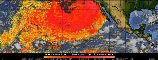
One thing's for sure, dry air is no longer a problem. Look at the CIMSS analysis for low and mid-level dry air. A big plus for strengthening if the shear stays down.
0 likes
Who is online
Users browsing this forum: No registered users and 31 guests