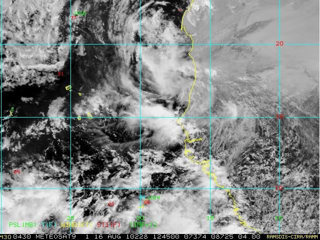
Disturbed weather in Eastern Atlantic (Is invest 95L)

This is the general tropical discussion area. Anyone can take their shot at predicting a storms path.

Moderator: S2k Moderators
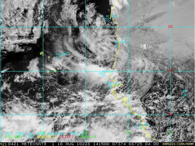
Forum rules

The posts in this forum are NOT official forecasts and should not be used as such. They are just the opinion of the poster and may or may not be backed by sound meteorological data. They are NOT endorsed by any professional institution or STORM2K. For official information, please refer to products from the National Hurricane Center and National Weather Service.

Help Support Storm2K
Message
Author
User avatar
Blown Away
S2K Supporter
S2K Supporter
Posts: 10146
Joined: Wed May 26, 2004 6:17 am

Re: Wave PGI-30L about to emerge West Africa (Models develop it)

#561 Postby Blown Away » Mon Aug 16, 2010 8:14 am

ColinDelia wrote:Image


This wave coming off the coast is the one the models develop?
0 likes   
Hurricane Eye Experience: David 79, Irene 99, Frances 04, Jeanne 04, Wilma 05... EYE COMING MY WAY IN 2024…
Hurricane Brush Experience: Andrew 92, Erin 95, Floyd 99, Matthew 16, Irma 17, Ian 22, Nicole 22…

User avatar
TheBurn
Category 2
Category 2
Posts: 540
Joined: Thu Jul 28, 2005 4:00 pm
Location: Rincon, PR

Re: Wave PGI-30L emerging West Africa (Models develop it)

#562 Postby TheBurn » Mon Aug 16, 2010 8:15 am

Image
0 likes   

User avatar
cycloneye
Admin
Admin
Posts: 145327
Age: 68
Joined: Thu Oct 10, 2002 10:54 am
Location: San Juan, Puerto Rico

Re: Wave PGI-30L emerging West Africa (Models develop it)

#563 Postby cycloneye » Mon Aug 16, 2010 8:15 am

This wave coming off the coast is the one the models develop?


This is it.
0 likes   
Visit the Caribbean-Central America Weather Thread where you can find at first post web cams,radars
and observations from Caribbean basin members Click Here

User avatar
HURAKAN
Professional-Met
Professional-Met
Posts: 46086
Age: 38
Joined: Thu May 20, 2004 4:34 pm
Location: Key West, FL
Contact:

#564 Postby HURAKAN » Mon Aug 16, 2010 8:18 am

Image

latest
0 likes   

User avatar
cycloneye
Admin
Admin
Posts: 145327
Age: 68
Joined: Thu Oct 10, 2002 10:54 am
Location: San Juan, Puerto Rico

Re: Wave PGI-30L emerging West Africa (Models develop it)

#565 Postby cycloneye » Mon Aug 16, 2010 8:22 am

From now on, lets watch how it evolves as it splashes into the water and enters a new enviroment. We have to see if it merges with the weaker wave in front, where will a true LLC forms and then we can start from there.
0 likes   
Visit the Caribbean-Central America Weather Thread where you can find at first post web cams,radars
and observations from Caribbean basin members Click Here

User avatar
StarmanHDB
Tropical Storm
Tropical Storm
Posts: 201
Age: 60
Joined: Wed Sep 02, 2009 7:59 pm
Location: West Palm Beach, Florida

Re: Wave PGI-30L emerging West Africa (Models develop it)

#566 Postby StarmanHDB » Mon Aug 16, 2010 8:39 am

cycloneye wrote:From now on, lets watch how it evolves as it splashes into the water and enters a new enviroment. We have to see if it merges with the weaker wave in front, where will a true LLC forms and then we can start from there.


Well said! After all this time, it's finally put up or shut up time for this wave and all of its model predictions!
0 likes   

User avatar
ColinDelia
S2K Supporter
S2K Supporter
Posts: 918
Joined: Mon Aug 29, 2005 5:52 am
Location: The Beach, FL

Re: Wave PGI-30L emerging West Africa (Models develop it)

#567 Postby ColinDelia » Mon Aug 16, 2010 9:02 am

From the HPC's Caribbean Forecast Discussion.

"ON THE MEDIUM TO LONG RANGE...THE CLIMATOLOGICAL MODELS ARE
CONVERGING ON A SIMILAR SOLUTION...WITH NEGATIVE MJO ANOMALIES
CONCENTRATING OVER THE FAR EASTERN TROPICAL ATLANTIC AND AFRICA.
THIS IS THE FIRST TIME IN A WHILE THAT THESE MODELS HAVE REACHED A
CONSENSUS...LETS SEE HOW LONG IT LASTS. UNDER THESE CONDITIONS THE
GFS AND UKMET CONTINUE TO SHOW POSSIBILITY OF CYCLOGENESIS...THE
GFS SOMEWHAT MORE OPTIMISTIC THAN THE UKMET. BOTH...HOWEVER...SEEM
SUGGEST THAT IS TIME WE START LOOKING EAST."
0 likes   

Frank2
Category 5
Category 5
Posts: 4061
Joined: Mon Jul 25, 2005 12:47 pm

Re: Wave PGI-30L emerging West Africa (Models develop it)

#568 Postby Frank2 » Mon Aug 16, 2010 9:03 am

Good morning everyone,

GFS shows a recurve, though its entry into the Atlantic is already north of 15N:

http://weather.unisys.com/gfsx/loop/gfsx_500p_loop.html
0 likes   

User avatar
ConvergenceZone
Category 5
Category 5
Posts: 5194
Joined: Fri Jul 29, 2005 1:40 am
Location: Northern California

Re: Wave PGI-30L emerging West Africa (Models develop it)

#569 Postby ConvergenceZone » Mon Aug 16, 2010 9:24 am

Frank2 wrote:Good morning everyone,

GFS shows a recurve, though its entry into the Atlantic is already north of 15N:

http://weather.unisys.com/gfsx/loop/gfsx_500p_loop.html


This one will probably recurve Frank2, but the one behind it probably won't....
0 likes   

User avatar
KWT
Category 5
Category 5
Posts: 31415
Joined: Tue Aug 17, 2004 11:02 am
Location: UK!!!

Re: Wave PGI-30L emerging West Africa (Models develop it)

#570 Postby KWT » Mon Aug 16, 2010 9:27 am

Frank2 wrote:Good morning everyone,

GFS shows a recurve, though its entry into the Atlantic is already north of 15N:

http://weather.unisys.com/gfsx/loop/gfsx_500p_loop.html


Oh without a doubt this recurves.

We are heading towards Dmin down there in the tropics so the convetion will likely weaken an awful lot in the next 6-9hrs as that occurs and the system gets used to its new set-up...
0 likes   
Personal Forecast Disclaimer:
The posts in this forum are NOT official forecast and should not be used as such. They are just the opinion of the poster and may or may not be backed by sound meteorological data. They are NOT endorsed by any professional institution or storm2k.org. For official information, please refer to the NHC and NWS products

User avatar
cycloneye
Admin
Admin
Posts: 145327
Age: 68
Joined: Thu Oct 10, 2002 10:54 am
Location: San Juan, Puerto Rico

Re: Wave PGI-30L emerging West Africa (Models develop it)

#571 Postby cycloneye » Mon Aug 16, 2010 9:30 am

The second system the models develop is in Niger right now but is for another topic. :)

Image
0 likes   
Visit the Caribbean-Central America Weather Thread where you can find at first post web cams,radars
and observations from Caribbean basin members Click Here

User avatar
ConvergenceZone
Category 5
Category 5
Posts: 5194
Joined: Fri Jul 29, 2005 1:40 am
Location: Northern California

#572 Postby ConvergenceZone » Mon Aug 16, 2010 9:34 am

Yea, the 2nd system is much more south, so I wouldn't think it would recurve. It might be a low rider
0 likes   

User avatar
KWT
Category 5
Category 5
Posts: 31415
Joined: Tue Aug 17, 2004 11:02 am
Location: UK!!!

#573 Postby KWT » Mon Aug 16, 2010 9:42 am

The GFS looks way too far north in setting up the 2nd system, that looks nonsense to me!

Still the first wave is still uncertain at least in terms of the evolution in the E.Atlantic, all the other models aren't nearly as agressive and are much slower in trying to develop it...
0 likes   
Personal Forecast Disclaimer:
The posts in this forum are NOT official forecast and should not be used as such. They are just the opinion of the poster and may or may not be backed by sound meteorological data. They are NOT endorsed by any professional institution or storm2k.org. For official information, please refer to the NHC and NWS products

User avatar
CourierPR
Category 5
Category 5
Posts: 1335
Age: 71
Joined: Tue Aug 31, 2004 7:53 pm
Location: Pompano Beach, Florida

Re: Wave PGI-30L emerging West Africa (Models develop it)

#574 Postby CourierPR » Mon Aug 16, 2010 9:44 am

Is this thread going to endure another day where the same few constantly post RECURVE scenarios? Now that the system has hit the water, can we start to discuss the system itself and not the projected models?! :roll:
Last edited by CourierPR on Mon Aug 16, 2010 9:46 am, edited 1 time in total.
0 likes   

User avatar
Vortex
S2K Supporter
S2K Supporter
Posts: 4644
Age: 53
Joined: Fri Aug 01, 2003 9:34 pm
Location: Hilton Head, SC

#575 Postby Vortex » Mon Aug 16, 2010 9:45 am

The second wave should emerge late Thursday/Friday
0 likes   

User avatar
cycloneye
Admin
Admin
Posts: 145327
Age: 68
Joined: Thu Oct 10, 2002 10:54 am
Location: San Juan, Puerto Rico

Re: Wave PGI-30L emerging West Africa (Models develop it)

#576 Postby cycloneye » Mon Aug 16, 2010 9:46 am

I am eagered to close the thread as soon is invested to then start from square one with the models and the system itself.
0 likes   
Visit the Caribbean-Central America Weather Thread where you can find at first post web cams,radars
and observations from Caribbean basin members Click Here

User avatar
HURAKAN
Professional-Met
Professional-Met
Posts: 46086
Age: 38
Joined: Thu May 20, 2004 4:34 pm
Location: Key West, FL
Contact:

#577 Postby HURAKAN » Mon Aug 16, 2010 9:47 am

Image

A lot of work to do
0 likes   

User avatar
CourierPR
Category 5
Category 5
Posts: 1335
Age: 71
Joined: Tue Aug 31, 2004 7:53 pm
Location: Pompano Beach, Florida

Re: Wave PGI-30L emerging West Africa (Models develop it)

#578 Postby CourierPR » Mon Aug 16, 2010 9:48 am

cycloneye wrote:I am eagered to close the thread as soon is invested to then start from square one with the models and the system itself.
AMEN! :D
0 likes   

User avatar
KWT
Category 5
Category 5
Posts: 31415
Joined: Tue Aug 17, 2004 11:02 am
Location: UK!!!

#579 Postby KWT » Mon Aug 16, 2010 9:48 am

You can see where any circulation is going to set-up but like 93L its a little too far north right now in this set-up, its probably dragging in alot of dry air.

Probably won't be an invest for a while yet cycloneye...
0 likes   
Personal Forecast Disclaimer:
The posts in this forum are NOT official forecast and should not be used as such. They are just the opinion of the poster and may or may not be backed by sound meteorological data. They are NOT endorsed by any professional institution or storm2k.org. For official information, please refer to the NHC and NWS products

User avatar
cycloneye
Admin
Admin
Posts: 145327
Age: 68
Joined: Thu Oct 10, 2002 10:54 am
Location: San Juan, Puerto Rico

Re:

#580 Postby cycloneye » Mon Aug 16, 2010 9:51 am

HURAKAN wrote:Image

A lot of work to do


I think as I look closely at the image that the main circulation is still inland over Senegal, by seeing those arking low clouds.
0 likes   
Visit the Caribbean-Central America Weather Thread where you can find at first post web cams,radars
and observations from Caribbean basin members Click Here


Return to “Talkin' Tropics”

Who is online

Users browsing this forum: duilaslol, GCANE, Ulf and 16 guests