ATL: Ex-Hurricane DANIELLE - Discussion

Moderator: S2k Moderators

Message
Author
User avatar
wxman57
Moderator-Pro Met
Moderator-Pro Met
Posts: 22978
Age: 67
Joined: Sat Jun 21, 2003 8:06 pm
Location: Houston, TX (southwest)

Re: ATL : INVEST 95L - DISCUSSION

#201 Postby wxman57 » Sat Aug 21, 2010 7:43 am

Tommedic wrote:I don't post as much as I used to. But I was wondering from some of the more experienced professionals, is there any way for NOAA to send there research aircraft over the CV area for detailed analysis to evaluate the formation of a storm and then determine better methods of getting better info in future to better prpeare for significant storm formations based on real data rather than just models. It just seems that there is a dead area of limited info to better decide when to designate resources for a system. I tend to think that we will see a consolidation of the disturbed weather and then when a real center can be determined then the models will be able to get a good handle.


That's exactly what they're doing out there this year. There's a project underway in two phases - August 15-31 and September 1-15. They are studying waves as they move off the coast of Africa to learn more about what causes them to develop. It's tied in with the CIMSS "PREDICT" website:

http://cimss.ssec.wisc.edu/tropic2/predict/
0 likes   

User avatar
wxman57
Moderator-Pro Met
Moderator-Pro Met
Posts: 22978
Age: 67
Joined: Sat Jun 21, 2003 8:06 pm
Location: Houston, TX (southwest)

Re: ATL : INVEST 95L - DISCUSSION

#202 Postby wxman57 » Sat Aug 21, 2010 7:51 am

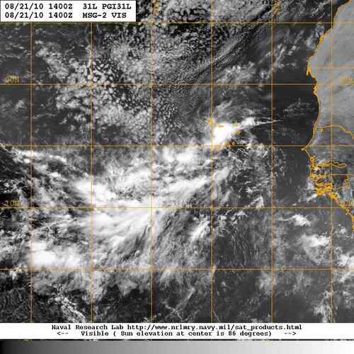
Looks like the monsoon gyre is slowly consolidating today. One thing that caught my eye is that the formerly horizontal orientation is tilting vertically. You can see an amplifying wave on the MIMIC TPW loop:

http://cimss.ssec.wisc.edu/tropic/real- ... /main.html

I see a couple areas of convergence, one near 11N/31W an the other rotating WNW and another near 13N/24W. Invest 95L remains focused on the western area. I do remain confident that this system is going to develop into a tropical cyclone, but these broad circulations take time to consolidate. Probably another 36-60 hrs - Sunday afternoon to Monday afternoon.

Oh, and I notice the ECMWF is no longer taking the system into the Bahamas. That's not to say such a track is not at least possible (my coworker thinks the ridge to its north may be stronger than forecast). But it's really hard to say what the setup will be to its north 5-7 days from now. Models often don't do well over the open oceans.

Nothing significant happening today, most likely, so I'm heading out on the bike for a 4 hour ride before the 100F temp hits this afteroon.
0 likes   

User avatar
ColinDelia
S2K Supporter
S2K Supporter
Posts: 918
Joined: Mon Aug 29, 2005 5:52 am
Location: The Beach, FL

ATL: INVEST 95L - MODELS

#203 Postby ColinDelia » Sat Aug 21, 2010 8:03 am

Current IR
Image

Current 850 mb vorticity
Image

Note the area of vorticity that is 50 units has expanded and now covers both rotations. This is the largest area covered by 50 units of vorticity since we've been tracking it. There are a few papers on vorticity based detection of tropical cyclogenesis and the idea in the papers is that you look at the vorticity summed over an area. The numbers are slightly different in each paper but this is a positive sign for development if it continues.
0 likes   

User avatar
ColinDelia
S2K Supporter
S2K Supporter
Posts: 918
Joined: Mon Aug 29, 2005 5:52 am
Location: The Beach, FL

Re: ATL: INVEST 95L - MODELS

#204 Postby ColinDelia » Sat Aug 21, 2010 8:08 am

Divergence
Image
0 likes   

User avatar
cycloneye
Admin
Admin
Posts: 145295
Age: 68
Joined: Thu Oct 10, 2002 10:54 am
Location: San Juan, Puerto Rico

Re: ATL : INVEST 95L - DISCUSSION

#205 Postby cycloneye » Sat Aug 21, 2010 8:11 am

Good analysis there 57. Lets see how it evolves.
0 likes   
Visit the Caribbean-Central America Weather Thread where you can find at first post web cams,radars
and observations from Caribbean basin members Click Here

User avatar
cycloneye
Admin
Admin
Posts: 145295
Age: 68
Joined: Thu Oct 10, 2002 10:54 am
Location: San Juan, Puerto Rico

Re: ATL : INVEST 95L - DISCUSSION

#206 Postby cycloneye » Sat Aug 21, 2010 9:02 am

Looks a little bit better.

Image
0 likes   
Visit the Caribbean-Central America Weather Thread where you can find at first post web cams,radars
and observations from Caribbean basin members Click Here

floridasun78
Category 5
Category 5
Posts: 3755
Joined: Sun May 17, 2009 10:16 pm
Location: miami fl

Re: ATL : INVEST 95L - DISCUSSION

#207 Postby floridasun78 » Sat Aug 21, 2010 9:15 am

i told you all it was too early to call this 95l a fish let see how play out
0 likes   

hurricaneCW
Category 5
Category 5
Posts: 1794
Joined: Wed Mar 03, 2010 6:20 am
Location: Toms River, NJ

Re: ATL : INVEST 95L - DISCUSSION

#208 Postby hurricaneCW » Sat Aug 21, 2010 9:22 am

This could be a large storm. It was a large circulation right now and is slowly organizing. All of those factors will determine what track it takes. The slower it moves and organizes, the further west it'll end up.
0 likes   

User avatar
AtlanticWind
S2K Supporter
S2K Supporter
Posts: 1888
Age: 66
Joined: Sun Aug 08, 2004 9:57 pm
Location: Plantation,Fla

Re: ATL : INVEST 95L - DISCUSSION

#209 Postby AtlanticWind » Sat Aug 21, 2010 9:26 am

I think we will have a TD by sometime late sunday.

http://www.ssd.noaa.gov/goes/east/catl/loop-rgb.html
0 likes   

User avatar
AtlanticWind
S2K Supporter
S2K Supporter
Posts: 1888
Age: 66
Joined: Sun Aug 08, 2004 9:57 pm
Location: Plantation,Fla

Re: ATL : INVEST 95L - DISCUSSION

#210 Postby AtlanticWind » Sat Aug 21, 2010 9:44 am

0 likes   

HUC
Category 2
Category 2
Posts: 590
Joined: Fri Oct 03, 2003 3:48 pm
Location: Basse-Terre Guadeloupe

Re: ATL : INVEST 95L - DISCUSSION

#211 Postby HUC » Sat Aug 21, 2010 9:56 am

JAMAIS LA NAISSANCE D'UN BEBE N'AURA ETE AUSSI ENTOUREE!!!! :lol:
0 likes   

User avatar
cycloneye
Admin
Admin
Posts: 145295
Age: 68
Joined: Thu Oct 10, 2002 10:54 am
Location: San Juan, Puerto Rico

Re: ATL : INVEST 95L - DISCUSSION

#212 Postby cycloneye » Sat Aug 21, 2010 10:00 am

HUC wrote:JAMAIS LA NAISSANCE D'UN BEBE N'AURA ETE AUSSI ENTOUREE!!!! :lol:


For the majority of us who dont know the French language,what does that sentence mean?
0 likes   
Visit the Caribbean-Central America Weather Thread where you can find at first post web cams,radars
and observations from Caribbean basin members Click Here

arkestra
S2K Supporter
S2K Supporter
Posts: 88
Joined: Wed Jan 03, 2007 7:24 pm
Location: The Old Continent

Re: ATL : INVEST 95L - DISCUSSION

#213 Postby arkestra » Sat Aug 21, 2010 10:09 am

cycloneye wrote:
HUC wrote:JAMAIS LA NAISSANCE D'UN BEBE N'AURA ETE AUSSI ENTOUREE!!!! :lol:


For the majority of us who dont know the French language,what does that sentence mean?


"THE BIRTH OF A BABY HAS NEVER BEEN SO MUCH SURROUNDED". Maybe not a proper English, but that's how I can translate it the best.
Last edited by arkestra on Sat Aug 21, 2010 10:12 am, edited 1 time in total.
0 likes   

Aric Dunn
Category 5
Category 5
Posts: 21238
Age: 42
Joined: Sun Sep 19, 2004 9:58 pm
Location: Ready for the Chase.
Contact:

#214 Postby Aric Dunn » Sat Aug 21, 2010 10:10 am

Its slowly getting there. It finally has become tilted SW to NE as I mentioned a couple days ago we would see before it developed. convection is becoming more concentrated and more circular. I imagine at 2pm we will see 60%
0 likes   
Note: If I make a post that is brief. Please refer back to previous posts for the analysis or reasoning. I do not re-write/qoute what my initial post said each time.
If there is nothing before... then just ask :)

Space & Atmospheric Physicist, Embry-Riddle Aeronautical University,
I believe the sky is falling...

User avatar
srainhoutx
S2K Supporter
S2K Supporter
Posts: 6919
Age: 67
Joined: Sun Jan 14, 2007 11:34 am
Location: Haywood County, NC
Contact:

Re: ATL : INVEST 95L - DISCUSSION

#215 Postby srainhoutx » Sat Aug 21, 2010 10:18 am

Still a ways to go IMO...

Image
0 likes   
Carla/Alicia/Jerry(In The Eye)/Michelle/Charley/Ivan/Dennis/Katrina/Rita/Wilma/Ike/Harvey

Member: National Weather Association
Wx Infinity Forums
http://wxinfinity.com/index.php

Facebook.com/WeatherInfinity
Twitter @WeatherInfinity

HUC
Category 2
Category 2
Posts: 590
Joined: Fri Oct 03, 2003 3:48 pm
Location: Basse-Terre Guadeloupe

Re: ATL : INVEST 95L - DISCUSSION

#216 Postby HUC » Sat Aug 21, 2010 10:20 am

It means that a lot of people since a lot of days, are around "mother nature "to assist the new-born of a baby closed to mama Africa, and me also! :D .I think that our friend gustywind could translate the sentence better that i can do.
Have a good day, cycloneye. Wait and see, all september is in front of us,and as said our great poet Aimé Césaire: "septembre accoucheuse de cyclones..." " september midwife of hurricanes"...
0 likes   

HUC
Category 2
Category 2
Posts: 590
Joined: Fri Oct 03, 2003 3:48 pm
Location: Basse-Terre Guadeloupe

Re: ATL : INVEST 95L - DISCUSSION

#217 Postby HUC » Sat Aug 21, 2010 10:25 am

Thank's Archestra, that's the right sense. Some of our friends should learn a little french,as we in the french Carribean made a lot of efforts to understand english,and spanish, and we are also speaking the creole (Gpe,Martinica, Dominica, St Lucia, Haiti...) :) :)
) Really the carribean is a great territory...
0 likes   

User avatar
AtlanticWind
S2K Supporter
S2K Supporter
Posts: 1888
Age: 66
Joined: Sun Aug 08, 2004 9:57 pm
Location: Plantation,Fla

Re: ATL : INVEST 95L - DISCUSSION

#218 Postby AtlanticWind » Sat Aug 21, 2010 10:26 am

http://www.ssd.noaa.gov/goes/east/catl/loop-rgb.html

There is a pretty clear center now at 31 west 11 north , i think we may have a depression as early as sunday morning
Last edited by AtlanticWind on Sat Aug 21, 2010 10:29 am, edited 1 time in total.
0 likes   

Hugo1989
Tropical Storm
Tropical Storm
Posts: 147
Joined: Mon Jun 14, 2010 9:09 am

Re: ATL : INVEST 95L - DISCUSSION

#219 Postby Hugo1989 » Sat Aug 21, 2010 10:29 am

Arkestra wrote:
cycloneye wrote:
HUC wrote:JAMAIS LA NAISSANCE D'UN BEBE N'AURA ETE AUSSI ENTOUREE!!!! :lol:


For the majority of us who dont know the French language,what does that sentence mean?


"THE BIRTH OF A BABY HAS NEVER BEEN SO MUCH SURROUNDED". Maybe not a proper English, but that's how I can translate it the best.


Esta pagina se esta volviendo una internacional. En fin, regresando a lo importante, cualquier sistema en el este del Atlantico a mediados de agosto y con las condiciones en el area como estan, no se le puede llamar "fish" independientemente las caracteristicas que este presente. Cualquier cosa que salga de Africa es buen candidato a desarrollo en cualquier momento.
0 likes   

Aric Dunn
Category 5
Category 5
Posts: 21238
Age: 42
Joined: Sun Sep 19, 2004 9:58 pm
Location: Ready for the Chase.
Contact:

Re: ATL : INVEST 95L - DISCUSSION

#220 Postby Aric Dunn » Sat Aug 21, 2010 10:35 am

The northern part that is thinning out should eventually weaken and allow the inflow to develop on the NE side of the clearly much more well defined CIRC at about 11N..But all in all it has improved a lot since last night and still looking about late sunday to early monday on upgrade..

Image
0 likes   
Note: If I make a post that is brief. Please refer back to previous posts for the analysis or reasoning. I do not re-write/qoute what my initial post said each time.
If there is nothing before... then just ask :)

Space & Atmospheric Physicist, Embry-Riddle Aeronautical University,
I believe the sky is falling...


Return to “2010”

Who is online

Users browsing this forum: No registered users and 2 guests