From Crown weather this morning:
[quote]Some final thoughts, the key to the forecast track of Earl is where and when exactly it will turn north and then northeast. The sharper the turn, the less impact on coastal North Carolina and coastal New England. If Earl makes a shallower turn, then the impacts to the coast will be greater. Today, I will be watching to see how close Earl gets to 30 North Latitude, 75 West Longitude. If Earl passes north of this area, then the turn is likely to be sharper and the impacts on the coast will be less. However, if Earl tracks either over or to the south of 30 North, 75 West, then it will be likely that Earl will make a shallower turn and it would in fact become more likely that the hurricane would track over the outer banks of North Carolina and then right over Cape Cod and eastern Maine.
For those of you in eastern North Carolina (especially the outer banks) and southeast Virginia today is the day to prepare for hurricane conditions. If your home is vulnerable to high winds or if you live in a storm surge area, evacuate to a designated shelter or ride out the storm in the sturdy home of family or friends outside of evacuation zones. Regarding your home or business, cover all windows and doors with shutters or plywood. Move patio furniture and other loose objects indoors. Brace all exterior doors, including garage doors. If you need to make a trip to the hardware store, the grocery store or the gas station, do so this morning. [quote]
http://www.crownweather.com/?page_id=325
ATL: Ex Tropical Storm EARL - Discussion
Moderator: S2k Moderators
-
lovestorms84
- Tropical Low

- Posts: 11
- Joined: Mon Aug 30, 2010 5:55 pm
- Location: Hampton Roads, VA

Re: ATL: Hurricane EARL - Discussion
lovestorms84 wrote:http://www.weather.com/maps/news/augustnonactive/tropicalatlanticsatellite_large_animated.html
Mmm...looks a bit less impressive....well, its at least a major hurricane.
Here's the threat level on the East Coast (Source: TWC)

Tropical Storm Advisories:

Hurricane Advisories:

0 likes
-
HugoCameandLeft
- Tropical Low
- Posts: 45
- Joined: Mon Aug 30, 2004 6:42 am
- Location: Charleston, SC
Re: ATL: Hurricane EARL - Discussion
Local mets seem to think that the only impact on Charleston will be very hot weather on Friday after it passes by... is it highly unlikely at this point that CHS will feel any affects at all, aside from surf/currents/etc? Hope so.
Last edited by HugoCameandLeft on Wed Sep 01, 2010 11:48 am, edited 1 time in total.
0 likes


-
brunota2003

- S2K Supporter

- Posts: 9476
- Age: 35
- Joined: Sat Jul 30, 2005 9:56 pm
- Location: Stanton, KY...formerly Havelock, NC
- Contact:
Re:
SootyTern wrote:From Crown weather this morning:Some final thoughts, the key to the forecast track of Earl is where and when exactly it will turn north and then northeast. The sharper the turn, the less impact on coastal North Carolina and coastal New England. If Earl makes a shallower turn, then the impacts to the coast will be greater. Today, I will be watching to see how close Earl gets to 30 North Latitude, 75 West Longitude. If Earl passes north of this area, then the turn is likely to be sharper and the impacts on the coast will be less. However, if Earl tracks either over or to the south of 30 North, 75 West, then it will be likely that Earl will make a shallower turn and it would in fact become more likely that the hurricane would track over the outer banks of North Carolina and then right over Cape Cod and eastern Maine.
For those of you in eastern North Carolina (especially the outer banks) and southeast Virginia today is the day to prepare for hurricane conditions. If your home is vulnerable to high winds or if you live in a storm surge area, evacuate to a designated shelter or ride out the storm in the sturdy home of family or friends outside of evacuation zones. Regarding your home or business, cover all windows and doors with shutters or plywood. Move patio furniture and other loose objects indoors. Brace all exterior doors, including garage doors. If you need to make a trip to the hardware store, the grocery store or the gas station, do so this morning.
http://www.crownweather.com/?page_id=325
If that is the case, it looks like Earl will cross 75W well south of 30N...unless his track changes to NNW here very soon. He is already at (just eyeballing this), 72.3W, and only 25.5N.
0 likes
-
TeamPlayersBlue

- Category 5

- Posts: 3531
- Joined: Tue Feb 02, 2010 1:44 am
- Location: Denver/Applewood, CO
Really happy that this dangerous storm is missing the coast.
Edit: or the worst of it is
Edit: or the worst of it is
Last edited by TeamPlayersBlue on Wed Sep 01, 2010 12:00 pm, edited 1 time in total.
0 likes
Personal Forecast Disclaimer:
The posts in this forum are NOT official forecast and should not be used as such. They are just the opinion of the poster and may or may not be backed by sound meteorological data. They are NOT endorsed by any professional institution or storm2k.org. For official information, please refer to the NHC and NWS products.
The posts in this forum are NOT official forecast and should not be used as such. They are just the opinion of the poster and may or may not be backed by sound meteorological data. They are NOT endorsed by any professional institution or storm2k.org. For official information, please refer to the NHC and NWS products.

-
MGC

- S2K Supporter
- Posts: 5940
- Joined: Sun Mar 23, 2003 9:05 pm
- Location: Pass Christian MS, or what is left.
Re: ATL: Hurricane EARL - Discussion
Beautiful day along the mid Atlantic...typical of the day before a big hurricane. No need for the eye to cross the beach in NC...get into the western eyewall will be enough to spread hurricane force winds along the coast. Upward along the coast expect TS force winds, rain and large waves along the coast....too early to tell how close the cyclone will come to Cape Cod and you folks up in the Canadian Maritime had better start preparing for a hurricane......MGC
0 likes
-
Category 5

- Category 5
- Posts: 10074
- Age: 36
- Joined: Sun Feb 11, 2007 10:00 pm
- Location: New Brunswick, NJ
- Contact:
Re: ATL: Hurricane EARL - Discussion
I will be hitting the Jersey Shore on Friday unless it gets close enough to kick up a storm surge. Pictures will be taken and posted.
0 likes

"GAME SET MATCH GIANTS WILL WIN THE NFC EAST and have a FIRST ROUND BYE with a win next week!!!" - StormingB81, the Giants lost, and did not win the NFC east.
-
SunnyThoughts
- Category 5
- Posts: 2263
- Joined: Wed Jul 09, 2003 12:42 pm
- Location: Pensacola, Florida

-
Category 5
- Category 5
- Posts: 10074
- Age: 36
- Joined: Sun Feb 11, 2007 10:00 pm
- Location: New Brunswick, NJ
- Contact:
Re: ATL: Hurricane EARL - Discussion
SunnyThoughts wrote:
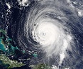
Can only imagine the waves in the Bahamas today
0 likes
"GAME SET MATCH GIANTS WILL WIN THE NFC EAST and have a FIRST ROUND BYE with a win next week!!!" - StormingB81, the Giants lost, and did not win the NFC east.
-
HurricaneBelle

- S2K Supporter
- Posts: 1209
- Joined: Sun Aug 27, 2006 6:12 pm
- Location: Clearwater, FL

-
JtSmarts

- S2K Supporter
- Posts: 1442
- Age: 40
- Joined: Thu Jul 10, 2003 1:29 pm
- Location: Columbia, South Carolina
Re: ATL: Hurricane EARL - Discussion
HurricaneBelle wrote:Looks like an Edna (1954) track in the making:
JB's been mentioning that on his twitter site. He supposedly goes into more detail on his Pro Site.
0 likes
-
RevDodd

- Tropical Storm

- Posts: 184
- Joined: Wed Aug 11, 2004 10:40 am
- Location: Fayetteville, NC
- Contact:
Re: Re:
If that is the case, it looks like Earl will cross 75W well south of 30N...unless his track changes to NNW here very soon. He is already at (just eyeballing this), 72.3W, and only 25.5N.
Agreed, Brunota: IIRC, the official track forecast slides Earl inside 30-75. If you figure he's at 72.5-25.5 now, to reach 75-30, Earl would have to climb 4.5 over 2.5 ... or north-northwest ... immediately.
0 likes

Re: ATL: Hurricane EARL - Discussion
pimentel2 wrote:lovestorms84 wrote:http://www.weather.com/maps/news/augustnonactive/tropicalatlanticsatellite_large_animated.html
Mmm...looks a bit less impressive....well, its at least a major hurricane.
Here's the threat level on the East Coast (Source: TWC)
Tropical Storm Advisories:
Hurricane Advisories:
...? It's looking better right now then it has in the past day or so
0 likes
-
hurricaneCW
- Category 5
- Posts: 1799
- Joined: Wed Mar 03, 2010 6:20 am
- Location: Toms River, NJ
Re: Re:
RevDodd wrote:
If that is the case, it looks like Earl will cross 75W well south of 30N...unless his track changes to NNW here very soon. He is already at (just eyeballing this), 72.3W, and only 25.5N.
Agreed, Brunota: IIRC, the official track forecast slides Earl inside 30-75. If you figure he's at 72.5-25.5 now, to reach 75-30, Earl would have to climb 4.5 over 2.5 ... or north-northwest ... immediately.
Well the NHC track barely takes it west of 75W. Only around 75.2. I guess they really expect it to turn more to the NNW soon.
0 likes
-
anarchiver19
- Tropical Low
- Posts: 33
- Joined: Mon Aug 30, 2010 10:45 am
- Location: Virginia Beach
Re: Re:
hurricaneCW wrote:RevDodd wrote:
If that is the case, it looks like Earl will cross 75W well south of 30N...unless his track changes to NNW here very soon. He is already at (just eyeballing this), 72.3W, and only 25.5N.
Agreed, Brunota: IIRC, the official track forecast slides Earl inside 30-75. If you figure he's at 72.5-25.5 now, to reach 75-30, Earl would have to climb 4.5 over 2.5 ... or north-northwest ... immediately.
Well the NHC track barely takes it west of 75W. Only around 75.2. I guess they really expect it to turn more to the NNW soon.
Sorry if I sound completely dense, can you explain a little more what this means?
0 likes
-
SunnyThoughts
- Category 5
- Posts: 2263
- Joined: Wed Jul 09, 2003 12:42 pm
- Location: Pensacola, Florida
Who is online
Users browsing this forum: No registered users and 56 guests