ATL: Ex-Tropical Storm HERMINE - Discussion
Moderator: S2k Moderators
-
bvigal

- S2K Supporter

- Posts: 2276
- Joined: Sun Jul 24, 2005 8:49 am
- Location: British Virgin Islands
- Contact:
Re: ATL: Tropical Storm HERMINE - Discussion
srainhoutx wrote:Some mighty cold cloud tops S of the center...
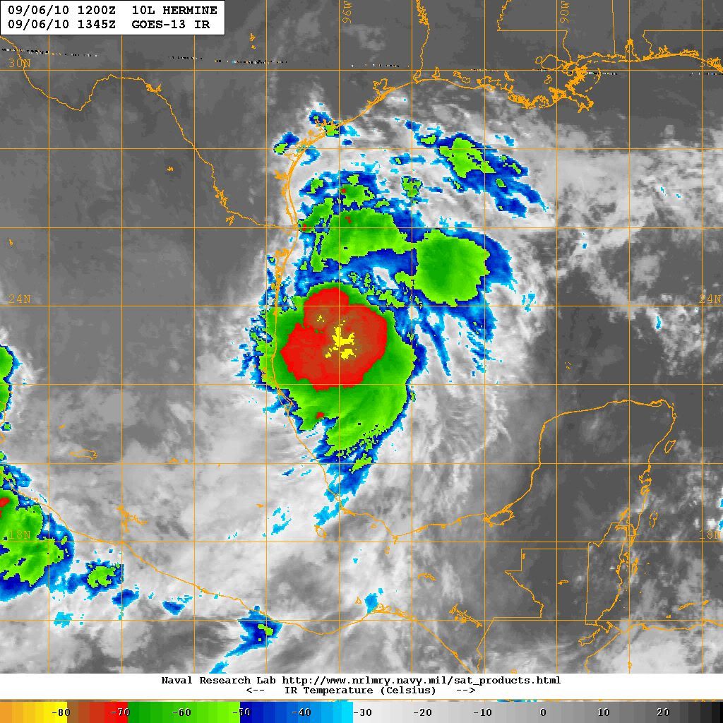
For sure! I'm very impressed with the buildup of clouds last few hours, have been watching on the SSD GOM (in order to see all of Texas coast) funk-top enhancement loop: http://www.ssd.noaa.gov/goes/east/gmex/flash-ft.html
0 likes
Re: ATL: Tropical Storm HERMINE - Discussion
Now moving NNW
PRESENT MOVEMENT TOWARD THE NORTH-NORTHWEST OR 340 DEGREES AT 11 KT
PRESENT MOVEMENT TOWARD THE NORTH-NORTHWEST OR 340 DEGREES AT 11 KT
0 likes

Slowly looks like its gaining more westerly motion over the past 12hrs or so, swang round from NNE to NNW and not that far from a NW track...N.Mexico/border landfall looking most likely now, think it'll make landfall just south of the border but obviously its going to be a somewhat close call either way!
0 likes
Personal Forecast Disclaimer:
The posts in this forum are NOT official forecast and should not be used as such. They are just the opinion of the poster and may or may not be backed by sound meteorological data. They are NOT endorsed by any professional institution or storm2k.org. For official information, please refer to the NHC and NWS products
The posts in this forum are NOT official forecast and should not be used as such. They are just the opinion of the poster and may or may not be backed by sound meteorological data. They are NOT endorsed by any professional institution or storm2k.org. For official information, please refer to the NHC and NWS products
Re: ATL: Tropical Storm HERMINE - Discussion
Probability of sustained winds of 34kt (39mph), 50kt (58mph), 64kt (74mph) by location as of 11am edt advisory:
GALVESTON 34KT 11%
GALVESTON 50KT 0%
GALVESTON 64KT 0%
PORT O CONNOR 34KT 32%
PORT O CONNOR 50KT 3%
PORT O CONNOR 64KT 0%
CORPUS CHRISTI 34KT 64%
CORPUS CHRISTI 50KT 17%
CORPUS CHRISTI 64KT 3%
BROWNSVILLE 34KT 87%
BROWNSVILLE 50KT 47%
BROWNSVILLE 64KT 8%
Even inland locations have some chance of strong winds (these are fairly low chances until you get to San Antonio and south - let's watch the trend of later updates to this):
HOUSTON 34KT 12%
HOUSTON 50KT 0%
HOUSTON 64KT 0%
AUSTIN 34KT 16%
AUSTIN 50KT 0%
AUSTIN 64KT 0%
SAN ANTONIO 34KT 30%
SAN ANTONIO 50KT 3%
SAN ANTONIO 64KT 0%
0 likes
-
cycloneye

- Admin

- Posts: 149586
- Age: 69
- Joined: Thu Oct 10, 2002 10:54 am
- Location: San Juan, Puerto Rico
Re: ATL: Tropical Storm HERMINE - Discussion
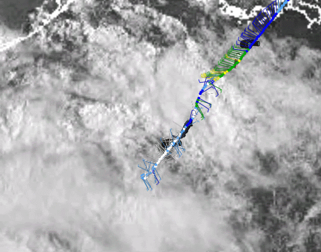
What happened to the plane that turned around?
0 likes
Visit the Caribbean-Central America Weather Thread where you can find at first post web cams,radars
and observations from Caribbean basin members Click Here
and observations from Caribbean basin members Click Here
-
PauleinHouston
- Tropical Storm

- Posts: 102
- Joined: Mon Aug 13, 2007 10:23 am
- Location: League City, TX
- Contact:
Re: ATL: Tropical Storm HERMINE - Discussion
Great question there...issue with plane possibly? Of course, if there was an issue, I would assume, being a pilot, that it would head for a closer land destination than it's origin....strange!!
0 likes
The posts in this forum are NOT official forecasts and should not be used as such. They are just the opinion of this amateur poster and may or may not be backed by sound meteorological data. They are NOT endorsed by any professional institution or storm2k.org. For official information, please refer to NWS products.
-
cycloneye
- Admin
- Posts: 149586
- Age: 69
- Joined: Thu Oct 10, 2002 10:54 am
- Location: San Juan, Puerto Rico
Re: ATL: Tropical Storm HERMINE - Discussion
PauleinHouston wrote:Great question there...issue with plane possibly? Of course, if there was an issue, I would assume, being a pilot, that it would head for a closer land destination than it's origin....strange!!
Look where it ended and turned around.
0 likes
Visit the Caribbean-Central America Weather Thread where you can find at first post web cams,radars
and observations from Caribbean basin members Click Here
and observations from Caribbean basin members Click Here
Re: ATL: Tropical Storm HERMINE - Discussion
Recon just doesn't like these BOC storms  Recall that a plane headed to Alex had to return to base because of radar problems. Probably the same case here.
0 likes
-
FrontRunner
- Tropical Depression

- Posts: 68
- Age: 42
- Joined: Wed Aug 23, 2006 9:01 pm
- Location: Westchester, NY
Re: ATL: Tropical Storm HERMINE - Discussion
Issue with the instrumentation perhaps? The wind readings looked pretty wacky (to my untrained eye) in the last couple sets of observations.
It would be a shame to miss out on getting a plane in this storm. Hopefully whatever the issue is they'll be able to resolve it and get another flight out there this evening.
It would be a shame to miss out on getting a plane in this storm. Hopefully whatever the issue is they'll be able to resolve it and get another flight out there this evening.
0 likes
-
PauleinHouston
- Tropical Storm
- Posts: 102
- Joined: Mon Aug 13, 2007 10:23 am
- Location: League City, TX
- Contact:
Re: ATL: Tropical Storm HERMINE - Discussion
Yeah, based on the reverse track coordinates so far, I'm guessing an issue with some of the data gathering systems on board. Smart thing to do would be to launch another now!
Last edited by PauleinHouston on Mon Sep 06, 2010 10:12 am, edited 1 time in total.
0 likes
The posts in this forum are NOT official forecasts and should not be used as such. They are just the opinion of this amateur poster and may or may not be backed by sound meteorological data. They are NOT endorsed by any professional institution or storm2k.org. For official information, please refer to NWS products.
-
Aric Dunn
- Category 5

- Posts: 21238
- Age: 43
- Joined: Sun Sep 19, 2004 9:58 pm
- Location: Ready for the Chase.
- Contact:
So I see the track shifted north to TX/mex border. not surprised
0 likes
Note: If I make a post that is brief. Please refer back to previous posts for the analysis or reasoning. I do not re-write/qoute what my initial post said each time.
If there is nothing before... then just ask
Space & Atmospheric Physicist, Embry-Riddle Aeronautical University,
I believe the sky is falling...
If there is nothing before... then just ask
Space & Atmospheric Physicist, Embry-Riddle Aeronautical University,
I believe the sky is falling...
-
dixiebreeze
- S2K Supporter
- Posts: 5140
- Joined: Wed Sep 03, 2003 5:07 pm
- Location: crystal river, fla.
Re:
CrazyC83 wrote:I remember last night people were laughing at me thinking this would go into rapid intensification...I was pretty much alone thinking we might see Hurricane Hermine.
I thought the same thing but decided not to post it. Also wondering if that strong front might push Hermine somewhat east.
0 likes


-
AdamFirst

- S2K Supporter
- Posts: 2490
- Age: 36
- Joined: Thu Aug 14, 2008 10:54 am
- Location: Port Saint Lucie, FL
Re: ATL: Tropical Storm HERMINE - Discussion
Unbelievable how this storm just sprang up overnight...you think Cantore is flying to brownsville as we speak?
0 likes
Dolphins Marlins Canes Golden Panthers HEAT
Andrew 1992 - Irene 1999 - Frances 2004 - Jeanne 2004 - Wilma 2005 - Fay 2008 - Isaac 2012 - Matthew 2016 - Irma 2017 - Dorian 2019 - Ian 2022 - Nicole 2022 - Milton 2024
Andrew 1992 - Irene 1999 - Frances 2004 - Jeanne 2004 - Wilma 2005 - Fay 2008 - Isaac 2012 - Matthew 2016 - Irma 2017 - Dorian 2019 - Ian 2022 - Nicole 2022 - Milton 2024
-
cycloneye
- Admin
- Posts: 149586
- Age: 69
- Joined: Thu Oct 10, 2002 10:54 am
- Location: San Juan, Puerto Rico
Re: ATL: Tropical Storm HERMINE - Discussion
Unless they scramble another plane for this afternoon, the next one is for the overnight hours.
Code: Select all
FLIGHT TWO -- TEAL 78
        A. 07/0600,1200Z
        B. AFXXX 0209A CYCLONE
        C. 07/0300Z
        D. 22.0N 97.5W
        E. 07/0500Z TO 1200Z
        F. SFC TO 15,000 FT
0 likes
Visit the Caribbean-Central America Weather Thread where you can find at first post web cams,radars
and observations from Caribbean basin members Click Here
and observations from Caribbean basin members Click Here
-
Portastorm

- Storm2k Moderator

- Posts: 9955
- Age: 63
- Joined: Fri Jul 11, 2003 9:16 am
- Location: Round Rock, TX
- Contact:
Re: ATL: Tropical Storm HERMINE - Discussion
utweather wrote:HurrMark wrote:wxman57 wrote:I think Hurricane Hermine will move ashore just north of Brownsville tomorrow morning. Fairly confident landfall won't be north of Corpus.
Well, if we are going to have a US landfall, that's the place to do it...Kenedy County...population 388.
Wow! I think most of us here were looking thousands of miles away in the Atlantic, checking out SAL and anything else, every once in while one of the models would show something in the western gulf but we'd say what is that and ignore it, but lo and behold something forms out of nowhere right under our noses, crazy
Well actually ... Hermine had model support late last week. The NAM was the only one who showed a deep tropical cyclone like we are seeing now. Most of us, including me, kinda laughed off the NAM. No one is laughing now.
0 likes
-
Stephanie

- S2K Supporter
- Posts: 23843
- Age: 63
- Joined: Thu Feb 06, 2003 9:53 am
- Location: Glassboro, NJ
Re: ATL: Tropical Storm HERMINE - Discussion
All of the action has been in the Atlantic this year except for one. I am surprised that this one sprung up a little unexpectedly. I hope you all just get some good rain from Hermine down there in Texas.
0 likes
-
Garnet1995
- Tropical Low

- Posts: 24
- Joined: Sun Aug 08, 2010 1:10 pm
Re: ATL: Tropical Storm HERMINE - Discussion
Anyone have thoughts about any preperations we should do in Houston. I am very West actually Richmond TX. We should prepare for heavy rains only is my thinking. I am sick and don't really want to think at all. Sorry I sound dumb but need to prepare and then sleep.
0 likes
-
ConvergenceZone
.gif)
- Category 5
- Posts: 5241
- Joined: Fri Jul 29, 2005 1:40 am
- Location: Northern California
Re: ATL: Tropical Storm HERMINE - Discussion
Texas really needs the rain from what I understand. Hopefully it won't come too quick. On the plus side, much of texas should see some rain from this, based upon the last precip forecast I saw.
0 likes
Who is online
Users browsing this forum: No registered users and 60 guests