ATL: IGOR - Ex Hurricane - Discussion

Moderator: S2k Moderators

Message
Author
ozonepete
Professional-Met
Professional-Met
Posts: 4743
Joined: Mon Sep 07, 2009 3:23 pm
Location: From Ozone Park, NYC / Now in Brooklyn, NY

Re: ATL: Hurricane IGOR - Discussion

#781 Postby ozonepete » Sun Sep 12, 2010 8:46 pm

Hurricanewatcher2007 wrote:
hurricaneCW wrote:The eye does appear to be contracting on satellite, but there is a nice ring of red around the eye. An EWRC will probably begin overnight and end sometime later tomorrow.


There's nothing to indicate a ERC will be starting any time soon. Hurricanes should have a intense ring of convection around the eye. In-fact a-lot of the most intense Hurricanes will have a solid intense ring of convection more then -80c around the eye. In the ssd IR loops -80c convection is represented as black. So far we have not seen that with Igor.


wxman_91 described very well the evidence that an ERC could be coming soon. BTW, Isabel, as have many other hurricanes, completed an ERC without any -80C cloudtops. And an ERC in a storm of this magnitude would be pretty common.

Also, as I said before, ISabel became a cat 5 AFTER it did an ERC. Since Igor is not even over the warmest SSTs yet, it could quite easily do an ERC in the next 12-24 hours and then go on to cat 5. Still reminds me of Isabel.
0 likes   

Florida1118

Re: ATL: Hurricane IGOR - Discussion

#782 Postby Florida1118 » Sun Sep 12, 2010 8:46 pm

Cyclenall wrote:
wxmann_91 wrote:I'll admit though, people in the northern Lesser Antilles who are watching the satellite must be sweating right now...

I think people in Bermuda are sweating bullets currently, I would be.

Yes, Bermudians must be biting their nails with the models bring Igor close to the Island
0 likes   

User avatar
wx247
S2K Supporter
S2K Supporter
Posts: 14279
Age: 41
Joined: Wed Feb 05, 2003 10:35 pm
Location: Monett, Missouri
Contact:

#783 Postby wx247 » Sun Sep 12, 2010 8:50 pm

What is the lat/long of San Juan, PR?
0 likes   
Personal Forecast Disclaimer:
The posts in this forum are NOT official forecast and should not be used as such. They are just the opinion of the poster and may or may not be backed by sound meteorological data. They are NOT endorsed by any professional institution or storm2k.org. For official information, please refer to the NHC and NWS products.

User avatar
cycloneye
Admin
Admin
Posts: 145351
Age: 68
Joined: Thu Oct 10, 2002 10:54 am
Location: San Juan, Puerto Rico

Re:

#784 Postby cycloneye » Sun Sep 12, 2010 8:52 pm

wx247 wrote:What is the lat/long of San Juan, PR?


18.3N-66.0W
0 likes   
Visit the Caribbean-Central America Weather Thread where you can find at first post web cams,radars
and observations from Caribbean basin members Click Here

User avatar
wxman57
Moderator-Pro Met
Moderator-Pro Met
Posts: 22979
Age: 67
Joined: Sat Jun 21, 2003 8:06 pm
Location: Houston, TX (southwest)

Re: ATL: Hurricane IGOR - Discussion

#785 Postby wxman57 » Sun Sep 12, 2010 8:53 pm

Take a look at a water vapor loop. It appears Igor is approaching the western edge of the ridge now. So it should begin a WNW motion by tomorrow. That should keep it well NE of the Caribbean.
0 likes   

User avatar
Fego
S2K Supporter
S2K Supporter
Posts: 767
Age: 65
Joined: Sun Apr 18, 2004 7:58 pm
Location: San Juan, Puerto Rico
Contact:

Re: ATL: Hurricane IGOR - Discussion

#786 Postby Fego » Sun Sep 12, 2010 8:57 pm

wxman57 wrote:Take a look at a water vapor loop. It appears Igor is approaching the western edge of the ridge now. So it should begin a WNW motion by tomorrow. That should keep it well NE of the Caribbean.

This water vapor loop?
http://www.ssd.noaa.gov/goes/east/carb/flash-wv.html
0 likes   
Go Giants! Go Niners! Go Warriors!

ozonepete
Professional-Met
Professional-Met
Posts: 4743
Joined: Mon Sep 07, 2009 3:23 pm
Location: From Ozone Park, NYC / Now in Brooklyn, NY

Re: ATL: Hurricane IGOR - Discussion

#787 Postby ozonepete » Sun Sep 12, 2010 8:58 pm

wxman57 wrote:Take a look at a water vapor loop. It appears Igor is approaching the western edge of the ridge now. So it should begin a WNW motion by tomorrow. That should keep it well NE of the Caribbean.


Looks to me Igor passed it already and hasn't turned.
0 likes   

User avatar
wxman57
Moderator-Pro Met
Moderator-Pro Met
Posts: 22979
Age: 67
Joined: Sat Jun 21, 2003 8:06 pm
Location: Houston, TX (southwest)

Re: ATL: Hurricane IGOR - Discussion

#788 Postby wxman57 » Sun Sep 12, 2010 9:03 pm

ozonepete wrote:
wxman57 wrote:Take a look at a water vapor loop. It appears Igor is approaching the western edge of the ridge now. So it should begin a WNW motion by tomorrow. That should keep it well NE of the Caribbean.


Looks to me Igor passed it already and hasn't turned.


Not yet, it will be at the western edge tomorrow. Should see the gradual turn starting tomorrow.
0 likes   

Steve H.
Category 5
Category 5
Posts: 2146
Joined: Sat Oct 19, 2002 9:06 am
Location: Palm Bay, Florida

Re: ATL: Hurricane IGOR - Discussion

#789 Postby Steve H. » Sun Sep 12, 2010 9:05 pm

Again, maybe my eyes are admittedly, not as good as they used to be, but it still looks like Igor is heading WSW.
0 likes   

plasticup

Re: ATL: Hurricane IGOR - Discussion

#790 Postby plasticup » Sun Sep 12, 2010 9:05 pm

Florida1118 wrote:Yes, Bermudians must be biting their nails with the models bring Igor close to the Island

They've had so many close calls this season, they won't even look at it until the Watches are up.
0 likes   

User avatar
sponger
S2K Supporter
S2K Supporter
Posts: 1620
Joined: Thu Jul 22, 2004 11:26 am
Location: St Augustine

Re: ATL: Hurricane IGOR - Discussion

#791 Postby sponger » Sun Sep 12, 2010 9:06 pm

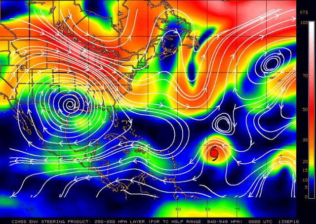
I hate to ask but can someone post the steering map?
0 likes   
The following post is NOT an official forecast and should not be used as such. It is just the opinion of the poster and may or may not be backed by sound meteorological data. It is NOT endorsed by any professional institution including storm2k.org For Official Information please refer to the NHC and NWS products.

Florida1118

Re: ATL: Hurricane IGOR - Discussion

#792 Postby Florida1118 » Sun Sep 12, 2010 9:07 pm

plasticup wrote:
Florida1118 wrote:Yes, Bermudians must be biting their nails with the models bring Igor close to the Island

They've had so many close calls this season, they won't even look at it until the Watches are up.

Well a Cat.4-5 Should be getting their attention them being in the middle of the Atlantic.
0 likes   

User avatar
Gustywind
Category 5
Category 5
Posts: 12334
Joined: Mon Sep 03, 2007 7:29 am
Location: Baie-Mahault, GUADELOUPE

#793 Postby Gustywind » Sun Sep 12, 2010 9:11 pm

Image
0 likes   

ozonepete
Professional-Met
Professional-Met
Posts: 4743
Joined: Mon Sep 07, 2009 3:23 pm
Location: From Ozone Park, NYC / Now in Brooklyn, NY

Re: ATL: Hurricane IGOR - Discussion

#794 Postby ozonepete » Sun Sep 12, 2010 9:11 pm

sponger wrote:I hate to ask but can someone post the steering map?


No problem. Here's the latest from CIMSS:

Image

Remember this is current steering. It will change over time...
0 likes   

User avatar
mf_dolphin
Category 5
Category 5
Posts: 17758
Age: 68
Joined: Tue Oct 08, 2002 2:05 pm
Location: St Petersburg, FL
Contact:

Re: ATL: Hurricane IGOR - Discussion

#795 Postby mf_dolphin » Sun Sep 12, 2010 9:16 pm

wxmann_91 wrote:
sponger wrote:I must admit it is looking more annular with every pass. Almost no spiral bands and a doughnt core.

Although a reading of 1 isn't so great. I give him a 15 at least. (Based on no scientific reasoning what so ever!

It's not annular... there have been plenty of small convective blowups on the periphery of the CDO (not characteristics of stable annular storms) and microwave images show numerous rainbands surrounding the eyewall.


mf_dolphin wrote:
hurricaneCW wrote:The eye does appear to be contracting on satellite, but there is a nice ring of red around the eye. An EWRC will probably begin overnight and end sometime later tomorrow.


Since there's absolutely no evidence I can see of a second eyewall forming I take that your statement is just a guess.

I can't judge whether he was guessing or not, but there is actually evidence for the start of an ERC tonight. First, microwave images show that outer rainbands are consolidating, which is a necessary precursor to an ERC. Second, in past intense hurricanes, I have observed ERC's to begin ~24 hours after the beginning of a RIC, often in the diurnal maximum subsequent to the one when the initial RIC occurred. Third, the eye is contracting and the cloud tops are cooling, which often signals the peak prior to the onset of an ERC.

Inductively I will argue that an ERC is likely to begin tonight, perhaps within the next 12 hr. Not guaranteed, of course - after all, Igor was a little closer to annular earlier today, so it might be a little more stable internally than most storms.


My point is that no evidence was offered other than the eye has slightly shrunk to support that an ERC would start tonight and be completed tomorrow. While I fully expect Igor to undergo an ERC at some point, right now I just don't see it starting to happen. The core looks extremely intense and very stable with no indication I've seen of a secondary eyewall even starting to form.
0 likes   

Florida1118

Re: ATL: Hurricane IGOR - Discussion

#796 Postby Florida1118 » Sun Sep 12, 2010 9:16 pm

If Im correct by Wed. the TS wind radius should be about the size of Louisiana...
0 likes   

User avatar
dixiebreeze
S2K Supporter
S2K Supporter
Posts: 5140
Joined: Wed Sep 03, 2003 5:07 pm
Location: crystal river, fla.

Re: ATL: Hurricane IGOR - Discussion

#797 Postby dixiebreeze » Sun Sep 12, 2010 9:21 pm

"My point is that no evidence was offered other than the eye has slightly shrunk to support that an ERC would start tonight and be completed tomorrow. While I fully expect Igor to undergo an ERC at some point, right now I just don't see it starting to happen. The core looks extremely intense and very stable with no indication I've seen of a secondary eyewall even starting to form."

Dolphin, the very "stability" of Igor is what makes me worry about a late turn (plus the slight SW bobbles).
0 likes   

User avatar
gatorcane
S2K Supporter
S2K Supporter
Posts: 23691
Age: 47
Joined: Sun Mar 13, 2005 3:54 pm
Location: Boca Raton, FL

#798 Postby gatorcane » Sun Sep 12, 2010 9:25 pm

Impressive hurricane I must say. Just about a zero chance of reaching the united states given the strong models consensus. It doesn't matter if it is a cat 10 it is not making it through that trough.
Last edited by gatorcane on Sun Sep 12, 2010 9:25 pm, edited 1 time in total.
0 likes   

plasticup

Re: ATL: Hurricane IGOR - Discussion

#799 Postby plasticup » Sun Sep 12, 2010 9:25 pm

wxman57 wrote:Doesn't appear annular to me. Still a good deal of banding north and south.

4-5 hours ago those bands did not appear connected to the main convective mass, but they have since joined it and appear to be true banding arms. I agree with you, and expect the annular rating to be withdrawn in the next interval.
0 likes   

hurricaneCW
Category 5
Category 5
Posts: 1794
Joined: Wed Mar 03, 2010 6:20 am
Location: Toms River, NJ

Re: ATL: Hurricane IGOR - Discussion

#800 Postby hurricaneCW » Sun Sep 12, 2010 9:26 pm

If Igor doesn't gain any latitude by 55W, then there's some cause for concern. Eye appears to be contracting even more now.
0 likes   


Return to “2010”

Who is online

Users browsing this forum: No registered users and 7 guests