Pouch PGI45L - SW of CV Islands - (Is invest 94L)

This is the general tropical discussion area. Anyone can take their shot at predicting a storms path.

Moderator: S2k Moderators

Forum rules

The posts in this forum are NOT official forecasts and should not be used as such. They are just the opinion of the poster and may or may not be backed by sound meteorological data. They are NOT endorsed by any professional institution or STORM2K. For official information, please refer to products from the National Hurricane Center and National Weather Service.

Help Support Storm2K
Message
Author
User avatar
cycloneye
Admin
Admin
Posts: 145308
Age: 68
Joined: Thu Oct 10, 2002 10:54 am
Location: San Juan, Puerto Rico

Re:

#61 Postby cycloneye » Mon Sep 13, 2010 2:37 pm

Vortex wrote:Day 9 Euro...No recurvature with this pattern...


http://raleighwx.easternuswx.com/models ... SLP216.gif


A hit to Puerto Rico?
0 likes   
Visit the Caribbean-Central America Weather Thread where you can find at first post web cams,radars
and observations from Caribbean basin members Click Here

User avatar
Vortex
S2K Supporter
S2K Supporter
Posts: 4644
Age: 53
Joined: Fri Aug 01, 2003 9:34 pm
Location: Hilton Head, SC

#62 Postby Vortex » Mon Sep 13, 2010 2:43 pm

Everything I see at this point points towards the carribean...Azores High will keep it west than as Igor kicks out to the N/NE ridging sets up nicely across the western Atlantic...This is the type of pattern that gets CV storms into the Carribean and further West...
0 likes   

User avatar
ColinDelia
S2K Supporter
S2K Supporter
Posts: 918
Joined: Mon Aug 29, 2005 5:52 am
Location: The Beach, FL

Re: GFS long range - PGI45L eventually to Caribbean&Gulf

#63 Postby ColinDelia » Mon Sep 13, 2010 2:49 pm

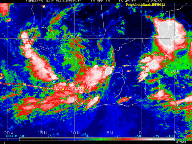
ColinDelia wrote:Right now there are two vorticity pools. One around 6N, One around 11 N. PREDICT project has the pouch come off at 7.5N
72 hours from now it has it around 8N, 21W. Euro about the same. GFS even a little south of there.


I did a historical search of TCs within 65 nm of 8N, 21W. No matches in any month, any year. Again, some evidence that if this comes off that far South it might travel west a ways without developing.
0 likes   

lonelymike
S2K Supporter
S2K Supporter
Posts: 634
Joined: Sat Jul 26, 2008 10:12 am
Location: walton county fla

Re: GFS long range - PGI45L eventually to Caribbean&Gulf

#64 Postby lonelymike » Mon Sep 13, 2010 3:25 pm

So what's the end result with the Euro, CMS and GFS Colin? Hurricane hits or just a wave into the Carib?

Need to plan on making the coffee if I'm going to stay up late watching Ivan, Rock and the rest of the late nite crew sit up arguing over the late nite model runs.
0 likes   


GO SEMINOLES

hurricaneCW
Category 5
Category 5
Posts: 1794
Joined: Wed Mar 03, 2010 6:20 am
Location: Toms River, NJ

Re: GFS long range - PGI45L eventually to Caribbean&Gulf

#65 Postby hurricaneCW » Mon Sep 13, 2010 4:31 pm

This is going to be a somewhat different pattern than it has been once Igor and Julia leave. There will be much more western Atlantic ridging although there could be more of a weakness in the central Atlantic around 45-50W. If a storm can stay rather low, than there's no reason why they can't make it into the Caribbean.
0 likes   

User avatar
Vortex
S2K Supporter
S2K Supporter
Posts: 4644
Age: 53
Joined: Fri Aug 01, 2003 9:34 pm
Location: Hilton Head, SC

#66 Postby Vortex » Mon Sep 13, 2010 4:40 pm

18Z GFS rolling...
0 likes   

User avatar
Vortex
S2K Supporter
S2K Supporter
Posts: 4644
Age: 53
Joined: Fri Aug 01, 2003 9:34 pm
Location: Hilton Head, SC

#67 Postby Vortex » Mon Sep 13, 2010 4:51 pm

H+36 moving off African coast at low latitude


http://www.nco.ncep.noaa.gov/pmb/nwprod ... n_036l.gif
0 likes   

User avatar
Vortex
S2K Supporter
S2K Supporter
Posts: 4644
Age: 53
Joined: Fri Aug 01, 2003 9:34 pm
Location: Hilton Head, SC

#68 Postby Vortex » Mon Sep 13, 2010 5:09 pm

0 likes   

User avatar
Vortex
S2K Supporter
S2K Supporter
Posts: 4644
Age: 53
Joined: Fri Aug 01, 2003 9:34 pm
Location: Hilton Head, SC

#69 Postby Vortex » Mon Sep 13, 2010 5:21 pm

H+96 continues west at low latitude.


http://www.nco.ncep.noaa.gov/pmb/nwprod ... n_096l.gif
0 likes   

User avatar
Vortex
S2K Supporter
S2K Supporter
Posts: 4644
Age: 53
Joined: Fri Aug 01, 2003 9:34 pm
Location: Hilton Head, SC

#70 Postby Vortex » Mon Sep 13, 2010 5:22 pm

0 likes   

User avatar
Vortex
S2K Supporter
S2K Supporter
Posts: 4644
Age: 53
Joined: Fri Aug 01, 2003 9:34 pm
Location: Hilton Head, SC

#71 Postby Vortex » Mon Sep 13, 2010 5:34 pm

Last edited by Vortex on Mon Sep 13, 2010 5:36 pm, edited 1 time in total.
0 likes   

User avatar
Vortex
S2K Supporter
S2K Supporter
Posts: 4644
Age: 53
Joined: Fri Aug 01, 2003 9:34 pm
Location: Hilton Head, SC

#72 Postby Vortex » Mon Sep 13, 2010 5:35 pm

0 likes   

User avatar
Vortex
S2K Supporter
S2K Supporter
Posts: 4644
Age: 53
Joined: Fri Aug 01, 2003 9:34 pm
Location: Hilton Head, SC

#73 Postby Vortex » Mon Sep 13, 2010 5:38 pm

looking like this is going to come into the islands based on the pattern..very low latitude...
0 likes   

O Town
S2K Supporter
S2K Supporter
Posts: 5205
Age: 52
Joined: Wed Sep 07, 2005 9:37 pm
Location: Orlando, Florida 28°35'35"N 81°22'55"W

#74 Postby O Town » Mon Sep 13, 2010 5:41 pm

Not nearly as impressive today. Seeing some spinning NW of where
they have PG145 marked as invest.


Image
0 likes   

#ORLANDOSTRONG

User avatar
KWT
Category 5
Category 5
Posts: 31415
Joined: Tue Aug 17, 2004 11:02 am
Location: UK!!!

#75 Postby KWT » Mon Sep 13, 2010 6:13 pm

The weaker it stays the greater the threat down the line though, its getting close to the time where the CV season starts to drain away....and the threat transfers into the Caribbean region.

I suspect we will have a player to watch maybe 5-7 days time just as the other systems in the basin either hit land or recurve away...
0 likes   
Personal Forecast Disclaimer:
The posts in this forum are NOT official forecast and should not be used as such. They are just the opinion of the poster and may or may not be backed by sound meteorological data. They are NOT endorsed by any professional institution or storm2k.org. For official information, please refer to the NHC and NWS products

hurricaneCW
Category 5
Category 5
Posts: 1794
Joined: Wed Mar 03, 2010 6:20 am
Location: Toms River, NJ

Re: GFS long range - PGI45L eventually to Caribbean&Gulf

#76 Postby hurricaneCW » Mon Sep 13, 2010 6:15 pm

The gfs indicates the next couple of Cape Verde systems will be low riders and slow developers. The subtropical ridging gets re-established across the Atlantic as well. Also, we're definitely getting closer to that time were it becomes difficult for Cape Verde systems to quickly develop far to the east. Late September and October could be the greatest period of a U.S. landfall threat this season.
0 likes   

User avatar
BigA
Professional-Met
Professional-Met
Posts: 1317
Joined: Sun Jul 24, 2005 10:56 pm

Re: GFS long range - PGI45L eventually to Caribbean&Gulf

#77 Postby BigA » Mon Sep 13, 2010 10:31 pm

18Z HWRF also appears to develop this at the end of the IGOR/Julia run
0 likes   

User avatar
ColinDelia
S2K Supporter
S2K Supporter
Posts: 918
Joined: Mon Aug 29, 2005 5:52 am
Location: The Beach, FL

#78 Postby ColinDelia » Tue Sep 14, 2010 5:25 am

0z GFS was really weird. It has the vorticity split into two separate storms at 60 hours around 20W.
No way.
0 likes   

User avatar
cycloneye
Admin
Admin
Posts: 145308
Age: 68
Joined: Thu Oct 10, 2002 10:54 am
Location: San Juan, Puerto Rico

Re: GFS long range - PGI45L eventually to Caribbean&Gulf

#79 Postby cycloneye » Tue Sep 14, 2010 5:41 am

ColinDelia, how does it look now on the vorticity front?
0 likes   
Visit the Caribbean-Central America Weather Thread where you can find at first post web cams,radars
and observations from Caribbean basin members Click Here

User avatar
KWT
Category 5
Category 5
Posts: 31415
Joined: Tue Aug 17, 2004 11:02 am
Location: UK!!!

#80 Postby KWT » Tue Sep 14, 2010 5:49 am

The 0z GFS looks more realistic for a late September La Nina track to me, which usually is prime time for Caribbean Crusiers.

The 06z GFS weakens the ridge thats been sitting over the SE states which IMO is a slightly odd move given its pretty much been in place for months and I don't see any major pattern shift either occuring...

That being said its track is more of a classic October type track...but I think 00z is closer to the mark then 06z...thankfully for Florida...though that type of track is one to keep in mind from the 06z!
0 likes   
Personal Forecast Disclaimer:
The posts in this forum are NOT official forecast and should not be used as such. They are just the opinion of the poster and may or may not be backed by sound meteorological data. They are NOT endorsed by any professional institution or storm2k.org. For official information, please refer to the NHC and NWS products


Return to “Talkin' Tropics”

Who is online

Users browsing this forum: Bobd33, gib, hurricanes1234, lilbump3000, riapal, RomP, scotto, StormWeather, USTropics and 32 guests