ATL: KARL - Ex-Hurricane - Discussion

Moderator: S2k Moderators

Message
Author
User avatar
vbhoutex
Storm2k Executive
Storm2k Executive
Posts: 29112
Age: 73
Joined: Wed Oct 09, 2002 11:31 pm
Location: Cypress, TX
Contact:

Re: ATL: INVEST 92L - Discussion

#801 Postby vbhoutex » Tue Sep 14, 2010 3:28 pm

Personal Forecast Disclaimer:
The posts in this forum are NOT official forecast and should not be used as such. They are just the opinion of the poster and may or may not be backed by sound meteorological data. They are NOT endorsed by any professional institution or storm2k.org. For official information, please refer to the NHC and NWS products.

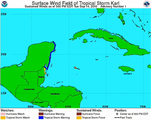
If they do go with 13 I don't think it will stay 13 for very long. Everything I am looking at says the same thing to me it seems to be saying to others "Hello, my name is Karl". Unfortunately possible Karl is in a very good location for some good intensification prior to landfall on the Yucatan so I would expect this system to keep ramping up till it hits the peninsula. Depending on how much the land interaction disturbs whatever we have out there now, I would guess it will have a good run at becoming a strong TS if not a CAT1 hurricane before it makes a 2nd landfall in Mexico, probably around Tampico or maybe a little North of there. The ridging over and expected to build in over TX appears to be the control here and it would appear that it will allow nothing to come North except moisture and some swells. Long fetch of winds from the SE might raise the tides above normal some along the TX coast also.
What I want to know is who allowed this to happen. My kids are cruising to Progresso and Cozumel right now. I think they get to Progresso this afternoon and Cozumel Thursday morning.
0 likes   
Skywarn, C.E.R.T.
Please click below to donate to STORM2K to help with the expenses of keeping the site going:
Image

cyclonic chronic

#802 Postby cyclonic chronic » Tue Sep 14, 2010 3:33 pm

http://www.ssd.noaa.gov/goes/flt/t2/rgb-l.jpg

starting to wrap up. its in the right place and time for a run at hurricane status. if it is at 50kts i could see a hurricane tommrow a.m., would only need 15-20kt.
0 likes   

Weatherfreak000

#803 Postby Weatherfreak000 » Tue Sep 14, 2010 3:34 pm

The model suite image said TC Karl...I tend to think that's solid enough but hey as before stated it doesn't really matter.
0 likes   

User avatar
SouthFloridawx
S2K Supporter
S2K Supporter
Posts: 8346
Age: 46
Joined: Tue Jul 26, 2005 1:16 am
Location: Sarasota, FL
Contact:

Re: ATL: INVEST 92L - Discussion

#804 Postby SouthFloridawx » Tue Sep 14, 2010 3:36 pm

Image
0 likes   

Weatherfreak000

#805 Postby Weatherfreak000 » Tue Sep 14, 2010 3:38 pm

The graveyard sure has been very unconducive towards development. I wonder if that ever will truly change this season. When all is said and done i'll be wondering back to classic invests like the first 92L that came so close.
0 likes   

Vortmax1
Category 1
Category 1
Posts: 360
Joined: Wed Jul 07, 2010 11:35 pm
Location: Port Salerno, FL
Contact:

#806 Postby Vortmax1 » Tue Sep 14, 2010 3:38 pm

Brownsville AFD is not banking on a strong ridge during this time period:


LONG TERM /THURSDAY THROUGH TUESDAY/...THE EXTENDED FORECAST
WILL BE HEAVILY INFLUENCED ON INVEST 92L CURRENTLY LOCATED ACROSS
THE NW CARIBBEAN SEA. NWP PROG 92L TO EMERGE INTO THE SW GULF
DURING THE DAY ON THURSDAY WHILE AT THE SAME TIME BRO CWA REMAINS
UNDER THE INFLUENCE OF A GRADUALLY WEAKENING MID LEVEL RIDGE OF
HIGH PRESSURE.
THURSDAY WILL BE HUMID AND UNSTABLE ESPECIALLY
ACROSS THE LOWER RIO GRANDE VALLEY. COMBINATION OF THESE TWO
FACTORS ALONG WITH A LIFTING MECHANISM /SEABREEZE/ HAVE LED ME TO
UP POPS TO 20 PERCENT FOR THE LOWER RGV.

CONFIDENCE IN FORECAST DECREASES BY FRIDAY AND THROUGH THE WEEKEND
DUE TO UNCERTAINTY ASSOCIATED WITH 92L TRACK AND STRENGTH. WARM SST
AND LOW SHEAR ACROSS THE SW GULF SHOULD ALLOW DEVELOPMENT /POSSIBLY
SIGNIFICANT/ OF THE SYSTEM TO OCCUR THROUGH LATE WEEK. 12Z EARLY
CYCLE TROPICAL MODEL TRACK GUIDANCE CONTINUE TO OFFER A VARIETY OF
SOLUTIONS WITH THE GFDL AND NOGAPS ADJUSTMENTS ALONG WITH THE RAW
GFS BEING THE FARTHEST SOUTH TAKING 92L W AND THEN SW TO NEAR
VERACRUZ MEXICO. THE 00Z ECMWF TRACKS THE INVEST TO JUST SOUTH OF
TAMPICO WHILE THIS MORNING/S BAMMS SUITE IS THE FARTHEST NORTH TO
NEAR AND JUST NORTH OF TAMPICO. BAMMS IS AT TIMES KNOWN TO PERFORM
DECENTLY AT THREE TO FIVE DAYS OUT SO IT IS SOMETHING TO KEEP IN
THE BACK OF THE MIND FOR THE NEXT FEW DAYS.

NO SIGNIFICANT CHANGES HAVE BEEN MADE TO THE EXTENDED FORECAST
FOR THIS TIME FRAME DUE TO THE UNCERTAINTY ASSOCIATED WITH THE
AFOREMENTIONED SYSTEM. IF THE SYSTEM STAYS FAR ENOUGH SOUTH OF CWA
AND DEVELOPS SIGNIFICANTLY THEN STRONG SUBSIDENCE WILL OCCUR
ACROSS DEEP SOUTH TEXAS KEEPING US DRY WITH HOT TEMPS IN THE MID
TO UPPER 90S. ANOTHER SCENARIO WOULD BE THE SYSTEM MOVING INTO
MEXICO SOMEWHERE BETWEEN TAMPICO AND BROWNSVILLE WHICH WOULD SEND
HIGH AMOUNTS OF DEEP TROPICAL MOISTURE AND SCATTERED
SHOWERS/STORMS ACROSS CWA ALONG WITH BREEZY CONDITIONS. I TWEAKED
TEMPERATURES SLIGHTLY WARMER ALONG THE COAST AND TWEAKED POPS
CLOSER TO AN ECMWF/GFS BLEND. AS ALLUDED TO EARLIER...FUTURE
FORECASTS WILL LIKELY CHANGE SIGNIFICANTLY ONCE THE TROPICAL
DISTURBANCE ENTERS THE SW GULF. RESIDENTS AND NWS PRODUCT USERS
ARE URGED TO REFER TO THE LATEST OUTLOOKS AND FORECASTS FROM THE
NATIONAL HURRICANE CENTER REGARDING THE PROGRESS OF THE CARIBBEAN
SYSTEM ALONG WITH ADDITIONAL TROPICAL WEATHER INFORMATION.
&&
0 likes   

User avatar
neospaceblue
Tropical Storm
Tropical Storm
Posts: 112
Age: 32
Joined: Fri Aug 10, 2007 3:17 pm
Location: Newport News, VA

Re:

#807 Postby neospaceblue » Tue Sep 14, 2010 3:41 pm

How likely is it that this will hit hurricane strength before reaching Mexico?
Last edited by neospaceblue on Tue Sep 14, 2010 3:42 pm, edited 1 time in total.
0 likes   

Vortmax1
Category 1
Category 1
Posts: 360
Joined: Wed Jul 07, 2010 11:35 pm
Location: Port Salerno, FL
Contact:

#808 Postby Vortmax1 » Tue Sep 14, 2010 3:42 pm

What I want to know is who allowed this to happen. My kids are cruising to Progresso and Cozumel right now. I think they get to Progresso this afternoon and Cozumel Thursday morning.


Oh Holy Wow vbhoutex!
I can't imagine how worried you must be right now.
0 likes   

Vortmax1
Category 1
Category 1
Posts: 360
Joined: Wed Jul 07, 2010 11:35 pm
Location: Port Salerno, FL
Contact:

#809 Postby Vortmax1 » Tue Sep 14, 2010 3:49 pm

Tropical Storm KARL Forecast/Advisory
--------------------------------------------------------------------------------
Home Fcst/Adv Archive
--------------------------------------------------------------------------------


ZCZC MIATCMAT3 ALL
TTAA00 KNHC DDHHMM
TROPICAL STORM KARL FORECAST/ADVISORY NUMBER 1
NWS TPC/NATIONAL HURRICANE CENTER MIAMI FL AL132010
2100 UTC TUE SEP 14 2010

CHANGES IN WATCHES AND WARNINGS WITH THIS ADVISORY...

THE GOVERNMENT OF MEXICO HAS ISSUED A TROPICAL STORM WARNING FOR THE
EAST COAST OF THE YUCATAN PENINSULA FROM CHETUMAL AT THE MEXICO/
BELIZE BORDER NORTHWARD TO CABO CATOCHE.

THE GOVERNMENT OF BELIZE HAS ISSUED A TROPICAL STORM WATCH FOR THE
COAST OF NORTHERN BELIZE FROM BELIZE CITY TO THE MEXICO/BELIZE
BORDER.

SUMMARY OF WATCHES AND WARNINGS IN EFFECT...

A TROPICAL STORM WARNING IS IN EFFECT FOR...
* THE EAST COAST OF THE YUCATAN PENINSULA FROM CHETUMAL AT THE
MEXICO/BELIZE BORDER NORTHWARD TO CABO CATOCHE

A TROPICAL STORM WATCH IN IN EFFECT FOR...
* THE COAST OF NORTHERN BELIZE FROM BELIZE CITY TO THE MEXICO/BELIZE
BORDER

A TROPICAL STORM WARNING MEANS THAT TROPICAL STORM CONDITIONS ARE
EXPECTED SOMEWHERE WITHIN THE WARNING AREA...IN THIS CASE WITHIN 24
HOURS.

A TROPICAL STORM WATCH MEANS THAT TROPICAL STORM CONDITIONS ARE
POSSIBLE WITHIN THE WATCH AREA...IN THIS CASE WITHIN 24 HOURS.

TROPICAL STORM CENTER LOCATED NEAR 18.3N 84.2W AT 14/2100Z
POSITION ACCURATE WITHIN 15 NM

PRESENT MOVEMENT TOWARD THE WEST-NORTHWEST OR 290 DEGREES AT 13 KT

ESTIMATED MINIMUM CENTRAL PRESSURE 1001 MB
MAX SUSTAINED WINDS 35 KT WITH GUSTS TO 45 KT.
34 KT....... 10NE 10SE 0SW 0NW.
12 FT SEAS.. 10NE 10SE 0SW 0NW.
WINDS AND SEAS VARY GREATLY IN EACH QUADRANT. RADII IN NAUTICAL
MILES ARE THE LARGEST RADII EXPECTED ANYWHERE IN THAT QUADRANT.

REPEAT...CENTER LOCATED NEAR 18.3N 84.2W AT 14/2100Z
AT 14/1800Z CENTER WAS LOCATED NEAR 18.1N 83.6W

FORECAST VALID 15/0600Z 18.9N 86.0W
MAX WIND 40 KT...GUSTS 50 KT.
34 KT... 30NE 30SE 0SW 0NW.

FORECAST VALID 15/1800Z 19.6N 88.1W...INLAND
MAX WIND 45 KT...GUSTS 55 KT.
34 KT... 50NE 50SE 30SW 30NW.

FORECAST VALID 16/0600Z 20.4N 90.3W...INLAND
MAX WIND 30 KT...GUSTS 40 KT.

FORECAST VALID 16/1800Z 21.0N 92.6W...OVER WATER
MAX WIND 35 KT...GUSTS 45 KT.
34 KT... 30NE 30SE 0SW 30NW.

FORECAST VALID 17/1800Z 21.5N 96.0W
MAX WIND 55 KT...GUSTS 65 KT.
50 KT... 30NE 20SE 20SW 30NW.
34 KT... 90NE 60SE 60SW 90NW.

EXTENDED OUTLOOK. NOTE...ERRORS FOR TRACK HAVE AVERAGED NEAR 200 NM
ON DAY 4 AND 250 NM ON DAY 5...AND FOR INTENSITY NEAR 20 KT EACH DAY

OUTLOOK VALID 18/1800Z 21.5N 99.5W...INLAND
MAX WIND 30 KT...GUSTS 40 KT.

OUTLOOK VALID 19/1800Z...DISSIPATED

REQUEST FOR 3 HOURLY SHIP REPORTS WITHIN 300 MILES OF 18.3N 84.2W

NEXT ADVISORY AT 15/0300Z

$$
FORECASTER BEVEN


NNNN
0 likes   

User avatar
JtSmarts
S2K Supporter
S2K Supporter
Posts: 1437
Age: 39
Joined: Thu Jul 10, 2003 1:29 pm
Location: Columbia, South Carolina

Re: ATL: Tropical Storm KARL - Discussion

#810 Postby JtSmarts » Tue Sep 14, 2010 3:53 pm

Image
0 likes   

superfly

Re: ATL: INVEST 92L - Discussion

#811 Postby superfly » Tue Sep 14, 2010 3:53 pm

vbhoutex wrote:What I want to know is who allowed this to happen. My kids are cruising to Progresso and Cozumel right now. I think they get to Progresso this afternoon and Cozumel Thursday morning.

They should be counting their lucky stars. Tropical storms are a blast to be in, nothing better than playing football in tropical storms.
0 likes   

Vortmax1
Category 1
Category 1
Posts: 360
Joined: Wed Jul 07, 2010 11:35 pm
Location: Port Salerno, FL
Contact:

#812 Postby Vortmax1 » Tue Sep 14, 2010 3:56 pm

Weren't a lot of us thinking this??


THE SYSTEM IS UPGRADED
STRAIGHT TO TROPICAL STORM KARL
0 likes   

User avatar
brunota2003
S2K Supporter
S2K Supporter
Posts: 9476
Age: 34
Joined: Sat Jul 30, 2005 9:56 pm
Location: Stanton, KY...formerly Havelock, NC
Contact:

#813 Postby brunota2003 » Tue Sep 14, 2010 4:07 pm

I spy with my little eye, a SMFR reading of 53 knots and no flag...though there are no other high ones around it that aren't flagged.
0 likes   

User avatar
HURAKAN
Professional-Met
Professional-Met
Posts: 46086
Age: 38
Joined: Thu May 20, 2004 4:34 pm
Location: Key West, FL
Contact:

#814 Postby HURAKAN » Tue Sep 14, 2010 4:32 pm

Image

Image

Nice pics
0 likes   

User avatar
Tampa Bay Hurricane
Category 5
Category 5
Posts: 5597
Age: 37
Joined: Fri Jul 22, 2005 7:54 pm
Location: St. Petersburg, FL

Re: ATL: KARL - Tropical Storm - Discussion

#815 Postby Tampa Bay Hurricane » Tue Sep 14, 2010 4:32 pm

Personal Forecast Disclaimer:
The posts in this forum are NOT official forecast and should not be used as such. They are just the opinion of the poster and may or may not be backed by sound meteorological data. They are NOT endorsed by any professional institution or storm2k.org. For official information, please refer to the NHC and NWS products.

With record heat content and low shear in the W. Car...I fully expect Karl to be at least a Category 1 80 mph Hurricane and possibly as high as 100 mph prior to Yucatan landfall...it can easily do that in 12-20 hours.

With Karl we have had 8 Named Storms in only 3.5 Weeks!!!!!!!!!!!!
Last edited by Tampa Bay Hurricane on Tue Sep 14, 2010 4:45 pm, edited 1 time in total.
0 likes   

User avatar
lester
S2K Supporter
S2K Supporter
Posts: 1305
Age: 36
Joined: Sat Aug 27, 2005 5:21 pm
Location: Washington, DC
Contact:

#816 Postby lester » Tue Sep 14, 2010 4:42 pm

VDM out.
0 likes   

User avatar
Iune
Category 1
Category 1
Posts: 291
Joined: Mon Aug 04, 2008 12:23 pm
Location: New York City

Re: ATL: KARL - Tropical Storm - Discussion

#817 Postby Iune » Tue Sep 14, 2010 5:06 pm

As of the operational data, TS winds extend 10 miles out from the center. This breaks TS Marco '08's record of 11.5 miles and makes Karl the smallest TC in the world.

Image
0 likes   
Floyd 1999 · Irene 2011 · Sandy 2012

User avatar
Aquawind
Category 5
Category 5
Posts: 6714
Age: 62
Joined: Mon Jun 16, 2003 10:41 pm
Location: Salisbury, NC
Contact:

Re:

#818 Postby Aquawind » Tue Sep 14, 2010 5:13 pm

Vortmax1 wrote:
What I want to know is who allowed this to happen. My kids are cruising to Progresso and Cozumel right now. I think they get to Progresso this afternoon and Cozumel Thursday morning.


Oh Holy Wow vbhoutex!
I can't imagine how worried you must be right now.


They are not going to cruise into a real threat with thousands on a boat.. they do change plans and will if they think a threat exists..
0 likes   

cyclonic chronic

#819 Postby cyclonic chronic » Tue Sep 14, 2010 5:17 pm

pressure dropping, recon at 1000.6mb D-max tonite should be interesting
0 likes   

User avatar
HURAKAN
Professional-Met
Professional-Met
Posts: 46086
Age: 38
Joined: Thu May 20, 2004 4:34 pm
Location: Key West, FL
Contact:

#820 Postby HURAKAN » Tue Sep 14, 2010 5:20 pm

Just like Alex, Karl should intensify steadily tonight.
0 likes   


Return to “2010”

Who is online

Users browsing this forum: No registered users and 2 guests