
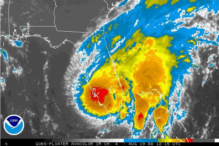
CI# /Pressure/ Vmax
5.3 / 965.5mb/ 97.2kt
Going down
ATL: KARL - Ex-Hurricane - Discussion
Moderator: S2k Moderators

-
South Texas Storms

- Professional-Met

- Posts: 4261
- Joined: Thu Jun 24, 2010 12:28 am
- Location: Houston, TX
Re: ATL: KARL - Tropical Storm - Discussion
goodness those are some cold cloud tops. should start to restrengthen rather quickly now thats its back over the warm waters of the boc.
0 likes
-
Brent
- S2K Supporter

- Posts: 38765
- Age: 37
- Joined: Sun May 16, 2004 10:30 pm
- Location: Tulsa Oklahoma
- Contact:
Re: ATL: KARL - Tropical Storm - Discussion
AL, 13, 2010091606, , BEST, 0, 197N, 912W, 45, 1000, TS, 34, NEQ, 15, 15, 60, 50, 1009, 120, 10, 0, 0, L,
Up to 50 mph
Up to 50 mph
0 likes
#neversummer


-
dwsqos2
Re: ATL: KARL - Tropical Storm - Discussion
Hour 48 of the 0Z Euro has this at 978 mb. In the deep tropics and prior to recurvature, the ECMWF's short-term pressure progs have been fairly accurate. This might be more appropriate for the model thread, but I just thought I would note it here.
0 likes

Karl already looking good, I see no reason why this can't strengthen upto say 90-95kts given the current trend, its already looking like its going to undergo some RI in the BoC...
0 likes
Personal Forecast Disclaimer:
The posts in this forum are NOT official forecast and should not be used as such. They are just the opinion of the poster and may or may not be backed by sound meteorological data. They are NOT endorsed by any professional institution or storm2k.org. For official information, please refer to the NHC and NWS products
The posts in this forum are NOT official forecast and should not be used as such. They are just the opinion of the poster and may or may not be backed by sound meteorological data. They are NOT endorsed by any professional institution or storm2k.org. For official information, please refer to the NHC and NWS products
Recon heading in there right now, would not surprise me at all to see pressures down into the 980mbs right now and wind speeds close to hurricane force, the system looks like its in the process of RI, deep convection has blown up over the center as well...
0 likes
Personal Forecast Disclaimer:
The posts in this forum are NOT official forecast and should not be used as such. They are just the opinion of the poster and may or may not be backed by sound meteorological data. They are NOT endorsed by any professional institution or storm2k.org. For official information, please refer to the NHC and NWS products
The posts in this forum are NOT official forecast and should not be used as such. They are just the opinion of the poster and may or may not be backed by sound meteorological data. They are NOT endorsed by any professional institution or storm2k.org. For official information, please refer to the NHC and NWS products

Wow...no wonder the Dvorak numbers shot upto 5.0 or so, that Microwave sure doesn't look like a system that has been overland for a while.
This one has to be a contender for RI in the next 12-24hrs...
This one has to be a contender for RI in the next 12-24hrs...
0 likes
Personal Forecast Disclaimer:
The posts in this forum are NOT official forecast and should not be used as such. They are just the opinion of the poster and may or may not be backed by sound meteorological data. They are NOT endorsed by any professional institution or storm2k.org. For official information, please refer to the NHC and NWS products
The posts in this forum are NOT official forecast and should not be used as such. They are just the opinion of the poster and may or may not be backed by sound meteorological data. They are NOT endorsed by any professional institution or storm2k.org. For official information, please refer to the NHC and NWS products
-
hurricaneCW
- Category 5

- Posts: 1799
- Joined: Wed Mar 03, 2010 6:20 am
- Location: Toms River, NJ
Re: ATL: KARL - Tropical Storm - Discussion
The following post is NOT an official forecast and should not be used as such. It is just the opinion of the poster and may or may not be backed by sound meteorological data. It is NOT endorsed by any professional institution including storm2k.org. For Official Information please refer to the NHC and NWS products.
I think Karl's RI could make it look like the eastern pacific's hurricane Darby of this year, except a little bigger. Darby rapidly intensified into a major hurricane but was incredibly tiny, could see the same thing happen with Karl.
I think Karl's RI could make it look like the eastern pacific's hurricane Darby of this year, except a little bigger. Darby rapidly intensified into a major hurricane but was incredibly tiny, could see the same thing happen with Karl.
0 likes
Either way I think conditions are good for Karl to really strengthen and its already clear this is on its way to hurricane status, its not if but just when and from the looks of things it's going to be sooner rather then later.
0 likes
Personal Forecast Disclaimer:
The posts in this forum are NOT official forecast and should not be used as such. They are just the opinion of the poster and may or may not be backed by sound meteorological data. They are NOT endorsed by any professional institution or storm2k.org. For official information, please refer to the NHC and NWS products
The posts in this forum are NOT official forecast and should not be used as such. They are just the opinion of the poster and may or may not be backed by sound meteorological data. They are NOT endorsed by any professional institution or storm2k.org. For official information, please refer to the NHC and NWS products
-
cycloneye

- Admin

- Posts: 149592
- Age: 69
- Joined: Thu Oct 10, 2002 10:54 am
- Location: San Juan, Puerto Rico
Re: ATL: KARL - Tropical Storm - Discussion
71kts at flight level and 985 mbs.
0 likes
Visit the Caribbean-Central America Weather Thread where you can find at first post web cams,radars
and observations from Caribbean basin members Click Here
and observations from Caribbean basin members Click Here
ell as expected recon has found some impressive winds, 70-71kts at FL probably does justify an upgrade....and if its not a hurricane now its going to be a matter of hours before it is!
I think the chances for this coming into landfall as a top end 2/3 is increasing rapidly this morning, some people are going to be surprised to see just how good Karl looks!
I think the chances for this coming into landfall as a top end 2/3 is increasing rapidly this morning, some people are going to be surprised to see just how good Karl looks!
0 likes
Personal Forecast Disclaimer:
The posts in this forum are NOT official forecast and should not be used as such. They are just the opinion of the poster and may or may not be backed by sound meteorological data. They are NOT endorsed by any professional institution or storm2k.org. For official information, please refer to the NHC and NWS products
The posts in this forum are NOT official forecast and should not be used as such. They are just the opinion of the poster and may or may not be backed by sound meteorological data. They are NOT endorsed by any professional institution or storm2k.org. For official information, please refer to the NHC and NWS products
-
plasticup
The Yucatan is so flat, so hot, and so wet that I wonder whether the powerful transpiration was fueling Karl in the way that evaporation powers a storm over the ocean. Obviously the water isn't as dense in vegetation as it is in the ocean, but the jungle has a much larger surface area from which it can evaporate.
For the curious, Tropical Storm Fay did something similar in 2008 over southern Florida: http://upload.wikimedia.org/wikipedia/c ... o_0045.gif
For the curious, Tropical Storm Fay did something similar in 2008 over southern Florida: http://upload.wikimedia.org/wikipedia/c ... o_0045.gif
0 likes
-
cycloneye
- Admin
- Posts: 149592
- Age: 69
- Joined: Thu Oct 10, 2002 10:54 am
- Location: San Juan, Puerto Rico
Re: ATL: KARL - Tropical Storm - Discussion
Breaking News
TROPICAL STORM KARL TROPICAL CYCLONE UPDATE
NWS TPC/NATIONAL HURRICANE CENTER MIAMI FL AL132010
700 AM CDT THU SEP 16 2010
...AIR FORCE AIRCRAFT FINDS KARL STRONGER...SPECIAL ADVISORY
FORTHCOMING...
RECENT DATA FROM AN AIR FORCE RESERVE RECONNAISSANCE AIRCRAFT
INDICATE THAT TROPICAL STORM KARL HAS MAXIMUM WINDS OF NEAR
65 MPH...100 KM/HR...AND A MINIMUM CENTRAL PRESSURE OF 986 MB...
29.12 IN.
A SPECIAL ADVISORY WILL BE ISSUED SHORTLY IN LIEU OF THE 700 AM
CDT...1200 UTC INTERMEDIATE PUBLIC ADVISORY.
SUMMARY OF 700 AM CDT...1200 UTC...INFORMATION
--------------------------------------------------
LOCATION...19.6N 92.1W
ABOUT 105 MI...170 KM W OF CAMPECHE MEXICO
MAXIMUM SUSTAINED WINDS...65 MPH...100 KM/HR
PRESENT MOVEMENT...W OR 285 DEGREES AT 9 MPH...15 KM/HR
MINIMUM CENTRAL PRESSURE...986 MB...29.26 INCHES
$$
FORECASTER STEWART/BEVEN
0 likes
Visit the Caribbean-Central America Weather Thread where you can find at first post web cams,radars
and observations from Caribbean basin members Click Here
and observations from Caribbean basin members Click Here
I'm a bit surprised they didn't go a little higher actually but they clearly believed the winds hadn't quite caught up with the wind speeds just yet...
I'm willing to bet the next forecast cycle from the NHC have Karl making landfall as a category-2 now...
I'm willing to bet the next forecast cycle from the NHC have Karl making landfall as a category-2 now...
0 likes
Personal Forecast Disclaimer:
The posts in this forum are NOT official forecast and should not be used as such. They are just the opinion of the poster and may or may not be backed by sound meteorological data. They are NOT endorsed by any professional institution or storm2k.org. For official information, please refer to the NHC and NWS products
The posts in this forum are NOT official forecast and should not be used as such. They are just the opinion of the poster and may or may not be backed by sound meteorological data. They are NOT endorsed by any professional institution or storm2k.org. For official information, please refer to the NHC and NWS products

Who is online
Users browsing this forum: No registered users and 30 guests