
10/1745 UTC 13.4N 80.8W T2.0/2.0 98L -- Atlantic
30 knots
ATL: Remnants of PAULA - Discussion
Moderator: S2k Moderators
-
cycloneye

- Admin

- Posts: 149586
- Age: 69
- Joined: Thu Oct 10, 2002 10:54 am
- Location: San Juan, Puerto Rico
Re: ATL : INVEST 98L - Discussion
Latest TAFB 72 hour forecast.

0 likes
Visit the Caribbean-Central America Weather Thread where you can find at first post web cams,radars
and observations from Caribbean basin members Click Here
and observations from Caribbean basin members Click Here

Re: ATL : INVEST 98L - Discussion
The way I look at it, if Best Track is correct, than we have a NNW moving system under moderate easterly shear, soon to be decimated by westerly shear. If I'm correct, than we might soon have a briefly named Tropical Storm - Paula , which though barely at the surface is moving more to the WNW and potentially short lived due to land interaction near the Nicarauga/Honduras border, and eventually with Belize.
0 likes
Andy D
(For official information, please refer to the NHC and NWS products.)
(For official information, please refer to the NHC and NWS products.)
-
Weatherfreak000
Re: ATL : INVEST 98L - Discussion
No fat lady is singing here...this thing would pretty much need to barrel into Central America not to develop at this point. The NHC is gonna have to answer up to a ton of extra TD time when they do post-analysis. I mean geez there are surface orbs everywhere.....dvorak has a 2.0.....
I mean no disrespect but this is yet again another example of the inconsistency the NHC displays regarding classification every single year and I think they owe the scientific community as well as us weather enthusiasts a reasonable explanation. I personally don't believe it's responsible to EVER have to add tons of storm time, they simply neglect to account for and un-named systems that seem to be forming just about every year nowadays.
To anyone that disagrees I completely respect your opinions. I am sure you can tell I clearly think this is a TD and I believe the only 60% percentage worth using here is well, looks like a 60% chance we wake up tomorrow and there is the P storm. I only ask one thing to anyone that disagrees, if we can want to take records like ACE seriously, does that not mean it should be 100% imperative on a scientific basis to be as close to 100% consistent with storm classification as humanly possible?
Personal Forecast Disclaimer:
The posts in this forum are NOT official forecast and should not be used as such. They are just the opinion of the poster and may or may not be backed by sound meteorological data. They are NOT endorsed by any professional institution or storm2k.org. For official information, please refer to the NHC and NWS products.
0 likes
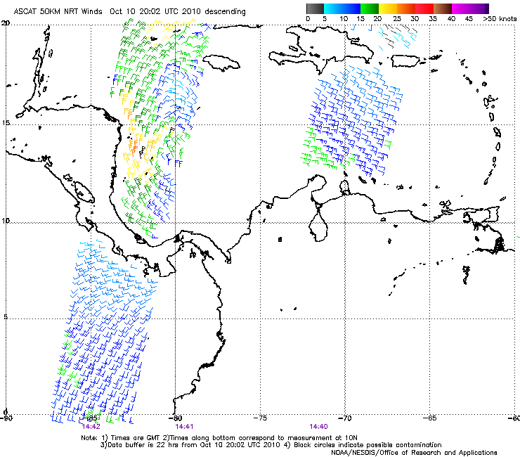
I agree that given this ASCAT

that this may already be a TD, although it looks somewhat enlongated and the lack of convection right at the center hurts it. However, your ACE argument doesn't make sense. TDs do not contribute at all to ACE, as it is only calculated for systems with at least 35kt sustained winds. Furthermore, low-grade TSs do not accumulate much ACE. For instance, a whole day of a 40kt TS garners only 0.48 of ACE, which is insignificant when looking back at a whole season.
that this may already be a TD, although it looks somewhat enlongated and the lack of convection right at the center hurts it. However, your ACE argument doesn't make sense. TDs do not contribute at all to ACE, as it is only calculated for systems with at least 35kt sustained winds. Furthermore, low-grade TSs do not accumulate much ACE. For instance, a whole day of a 40kt TS garners only 0.48 of ACE, which is insignificant when looking back at a whole season.
0 likes
Re: ATL : INVEST 98L - Discussion
"...I mean geez there are surface orbs everywhere.....dvorak has a 2.0....."
'Freak, in a way I kinda agree with you, but also NHC. I believe a new center is or has formed more towards the west and more co-located under the convection. If so, than I would probably argue calling the system a depression. However, if NHC continues to follow and plot the swirl located at the Dvorak ( Best Track ) coordinates, than their argument would understandably be that the system continues to lack a centralized COC with any convective banding, while all the deep convection remains displaced to the west. Furthermore, until such a time that any new center can be determined to have relocated, surface convergence would appear to be further compromised to the north, due to a persistent vorticity which though limited, is robbing 98L of ideal inflow. This other feature is interesting, yet already far enough to the north ( 18/19N ) that it appears to be getting fanned by the brisk WSW'erly shear present there.
'Freak, in a way I kinda agree with you, but also NHC. I believe a new center is or has formed more towards the west and more co-located under the convection. If so, than I would probably argue calling the system a depression. However, if NHC continues to follow and plot the swirl located at the Dvorak ( Best Track ) coordinates, than their argument would understandably be that the system continues to lack a centralized COC with any convective banding, while all the deep convection remains displaced to the west. Furthermore, until such a time that any new center can be determined to have relocated, surface convergence would appear to be further compromised to the north, due to a persistent vorticity which though limited, is robbing 98L of ideal inflow. This other feature is interesting, yet already far enough to the north ( 18/19N ) that it appears to be getting fanned by the brisk WSW'erly shear present there.
0 likes
Andy D
(For official information, please refer to the NHC and NWS products.)
(For official information, please refer to the NHC and NWS products.)
-
Florida1118
Re: ATL : INVEST 98L - Discussion
They may upgrade it soon, just have it at 60% BECAUSE of the lack of model support. They should be upgrading soon...I hope.
0 likes
-
SouthDadeFish

- Professional-Met

- Posts: 2836
- Joined: Thu Sep 23, 2010 2:54 pm
- Location: Miami, FL
- Contact:
-
x-y-no

- Category 5

- Posts: 8359
- Age: 65
- Joined: Wed Aug 11, 2004 12:14 pm
- Location: Fort Lauderdale, FL
Re: ATL : INVEST 98L - Discussion
OK ... can someone explain what the heck is going on with these wind-barbs?

Are they plotted backwards by accident?
Are they plotted backwards by accident?
0 likes
-
Blown Away

- S2K Supporter

- Posts: 10253
- Joined: Wed May 26, 2004 6:17 am
Re: ATL : INVEST 98L - Discussion
TAFB has been consistent bringing 98L into the NW Caribbean after skimming the Honduras coast. The slow movement looks NW or NNW, so the TAFB solution seems reasonable. A few models show 98L moving WNW now towards CA and bury 98L over land, doesn't seem likely right now and that means I have to discount the TCVN consensus, which I don't like to do.  JMHO
JMHO
0 likes
Hurricane Eye Experience: David 79, Irene 99, Frances 04, Jeanne 04, Wilma 05… Hurricane Brush Experience: Andrew 92, Erin 95, Floyd 99, Matthew 16, Irma 17, Ian 22, Nicole 22…

-
x-y-no
- Category 5
- Posts: 8359
- Age: 65
- Joined: Wed Aug 11, 2004 12:14 pm
- Location: Fort Lauderdale, FL
Re:
supercane wrote:x-y-no, those are the winds that ASCAT reported, and if true, are not entirely consistent with a well-organized circulation. From OSI's site,
...
Again, no one denies the presence of a low, but the question remains as to how well organized it is.
Hmmm ... makes no sense that there would be an area of anti-cyclonic veering in the midst of a low ... awfully suspicious looking to me.
0 likes
-
Dean4Storms
- S2K Supporter
- Posts: 6358
- Age: 63
- Joined: Sun Aug 31, 2003 1:01 pm
- Location: Miramar Bch. FL

The circulation appears to be is opening up and modest SE shear is blowing the tops off to the NW. The models indicating little development once again appear to have the right idea...We may get a storm out of the western carribean late in the month but I'm not expecting much the next 7-10 days....
0 likes
NWS Miami:
.EXTENDED FORECAST...
A COLD FRONT OVER THE CENTRAL UNITED STATES WILL MOVE SOUTHEAST
AND THROUGH SOUTH FLORIDA LATE THIS WEEK. THIS WILL PUSH THE TROUGH
OF LOW PRESSURE BACK SOUTH AND THE MOISTURE ASSOCIATED WITH IT.
THIS WILL ALLOW FOR DRY WEATHER TO RETURN TO THE CWA LATE THIS
WEEK INTO NEXT WEEKEND.
0 likes
-
jconsor
- Professional-Met
- Posts: 581
- Joined: Mon Jun 30, 2008 9:31 pm
- Location: Jerusalem, Israel
- Contact:
Re: ATL : INVEST 98L - Discussion
Yes, the wind barbs on the east side of the system are clearly backwards. Compare the NNW barbs on the east side of the system with the barbs adjacent to them and you can see that.
x-y-no wrote:OK ... can someone explain what the heck is going on with these wind-barbs?
Are they plotted backwards by accident?
0 likes
-
jconsor
- Professional-Met
- Posts: 581
- Joined: Mon Jun 30, 2008 9:31 pm
- Location: Jerusalem, Israel
- Contact:
Re:
Take a close look at the visible loop here (http://weather.msfc.nasa.gov/GOES/goeseastconus.html) and you will see that the low-level level circulation is reforming further NW, about 50 miles SE of the Nicaragua/Honduras coastal border. If anything, this circulation is tightening with improved banding in the past few hours. This reforming northward was indicated by all global models.
Vortex wrote:The circulation appears to be is opening up and modest SE shear is blowing the tops off to the NW. The models indicating little development once again appear to have the right idea...We may get a storm out of the western carribean late in the month but I'm not expecting much the next 7-10 days....
Last edited by jconsor on Sun Oct 10, 2010 3:24 pm, edited 1 time in total.
0 likes
Re: ATL : INVEST 98L - Discussion
If this mess can somehow stay clear of land interaction, than would assume should have a short lived opportunity to earn a name sometime tomorrow.
0 likes
Andy D
(For official information, please refer to the NHC and NWS products.)
(For official information, please refer to the NHC and NWS products.)
-
srainhoutx

- S2K Supporter
- Posts: 6919
- Age: 68
- Joined: Sun Jan 14, 2007 11:34 am
- Location: Haywood County, NC
- Contact:
Re: ATL : INVEST 98L - Discussion
To add to jconsor post, the latest ASCAT pass does give pause to the possiblity that the center is reforming further N...
Edit to add visible imagery and you can see that changes are occurring...
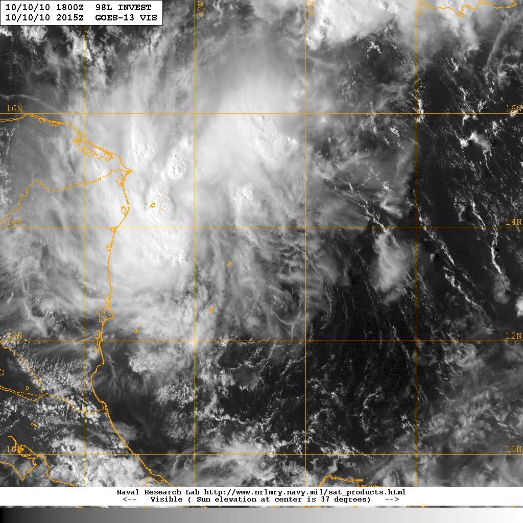
Edit to add visible imagery and you can see that changes are occurring...
0 likes
Carla/Alicia/Jerry(In The Eye)/Michelle/Charley/Ivan/Dennis/Katrina/Rita/Wilma/Ike/Harvey
Member: National Weather Association
Wx Infinity Forums
http://wxinfinity.com/index.php
Facebook.com/WeatherInfinity
Twitter @WeatherInfinity
Member: National Weather Association
Wx Infinity Forums
http://wxinfinity.com/index.php
Facebook.com/WeatherInfinity
Twitter @WeatherInfinity
Who is online
Users browsing this forum: No registered users and 62 guests