

Looks a little sheared to me actually looking at the Vis.imagery, its CLEAR as day this is at least a depression, you don't need recon to see this is a closed low, just looking at the Vis imagery and how strong the eastern side is is pretty much a giveaway, I bet its not even marginal.
ps, that ob overland also makes it perfectly obvious there is a decent LLC in place.
ATL: Remnants of PAULA - Discussion
Moderator: S2k Moderators
0 likes
Personal Forecast Disclaimer:
The posts in this forum are NOT official forecast and should not be used as such. They are just the opinion of the poster and may or may not be backed by sound meteorological data. They are NOT endorsed by any professional institution or storm2k.org. For official information, please refer to the NHC and NWS products
The posts in this forum are NOT official forecast and should not be used as such. They are just the opinion of the poster and may or may not be backed by sound meteorological data. They are NOT endorsed by any professional institution or storm2k.org. For official information, please refer to the NHC and NWS products
-
Evil Jeremy

- S2K Supporter

- Posts: 5463
- Age: 32
- Joined: Mon Apr 10, 2006 2:10 pm
- Location: Los Angeles, CA
Really though, the Special TWO I think means that once they have recon support, they will issue a Special Advisory. It wouldn't surprise me if they are already drafting the advisory, and just waiting for recon's information for..... whatever reason.
0 likes
Frances 04 / Jeanne 04 / Katrina 05 / Wilma 05 / Fay 08 / Debby 12 / Andrea 13 / Colin 16 / Hermine 16 / Matthew 16 / Irma 17
I'm not sure what information the NHC are waiting for from recon, I highly doubt recon will be able to sample the southern side anyway given the position of the system so the only thing they are going to learn is whether this is has TD/TS winds or not I'd have thought?
0 likes
Personal Forecast Disclaimer:
The posts in this forum are NOT official forecast and should not be used as such. They are just the opinion of the poster and may or may not be backed by sound meteorological data. They are NOT endorsed by any professional institution or storm2k.org. For official information, please refer to the NHC and NWS products
The posts in this forum are NOT official forecast and should not be used as such. They are just the opinion of the poster and may or may not be backed by sound meteorological data. They are NOT endorsed by any professional institution or storm2k.org. For official information, please refer to the NHC and NWS products
-
CrazyC83
- Professional-Met

- Posts: 34315
- Joined: Tue Mar 07, 2006 11:57 pm
- Location: Deep South, for the first time!
Re:
KWT wrote:I'm not sure what information the NHC are waiting for from recon, I highly doubt recon will be able to sample the southern side anyway given the position of the system so the only thing they are going to learn is whether this is has TD/TS winds or not I'd have thought?
If that is the case, they should just initialize as TD18 right now then upgrade to Paula if needed at the 2 pm intermediate.
0 likes
-
SouthDadeFish

- Professional-Met
- Posts: 2836
- Joined: Thu Sep 23, 2010 2:54 pm
- Location: Miami, FL
- Contact:
Re: Re:
CrazyC83 wrote:KWT wrote:I'm not sure what information the NHC are waiting for from recon, I highly doubt recon will be able to sample the southern side anyway given the position of the system so the only thing they are going to learn is whether this is has TD/TS winds or not I'd have thought?
If that is the case, they should just initialize as TD18 right now then upgrade to Paula if needed at the 2 pm intermediate.
Many of us think they should do that
0 likes

-
SouthDadeFish
- Professional-Met
- Posts: 2836
- Joined: Thu Sep 23, 2010 2:54 pm
- Location: Miami, FL
- Contact:
Re:
HURAKAN wrote:A very "Special" day:
Special Tropical Weather Discussion
Special Tropical Weather Outlook
maybe later today,
Special Advisory
Haha, let's just hope this storm doesn't turn out to be "special." I'm beginning to think the trough that's sticking out the NE of the circulation is helping 98L more than hindering it now. It seems to aid in moistening up the bone dry path ahead of it.
0 likes

Re: ATL : INVEST 98L - Discussion - 11:30 AM Special TWO=80%
Hope you guys don't mind if I join the discussion here. I found this thread via googling Invest 98.
I am actually traveling to the yucatan peninsula (a few miles south of Playa Del Carmen) for vacation this week. We are scheduled to arrive Thursday around noon. Since I am not well versed in this forecasting stuff, anyone have any thoughts on when this thing will be hitting that area?
If this is not pertinent to this board, I understand. Feel free to delete this thread.
Didnt mean to

Thanks! Josh
I am actually traveling to the yucatan peninsula (a few miles south of Playa Del Carmen) for vacation this week. We are scheduled to arrive Thursday around noon. Since I am not well versed in this forecasting stuff, anyone have any thoughts on when this thing will be hitting that area?
If this is not pertinent to this board, I understand. Feel free to delete this thread.
Didnt mean to
Thanks! Josh
0 likes

Re: ATL : INVEST 98L - Discussion - 11:30 AM Special TWO=80%
We still need to watch the closest buoy which is not all that far away.
Surface pressures are still steady,
Surface pressures are still steady,
0 likes
-
Blown Away

- S2K Supporter
- Posts: 10253
- Joined: Wed May 26, 2004 6:17 am
Re: ATL : INVEST 98L - Discussion - 11:30 AM Special TWO=80%
If/when 98L gets upgraded will the the 120 hour position be at hurricane status? I say yes!
0 likes
Hurricane Eye Experience: David 79, Irene 99, Frances 04, Jeanne 04, Wilma 05… Hurricane Brush Experience: Andrew 92, Erin 95, Floyd 99, Matthew 16, Irma 17, Ian 22, Nicole 22…
Re: ATL : INVEST 98L - Discussion - 11:30 AM Special TWO=80%
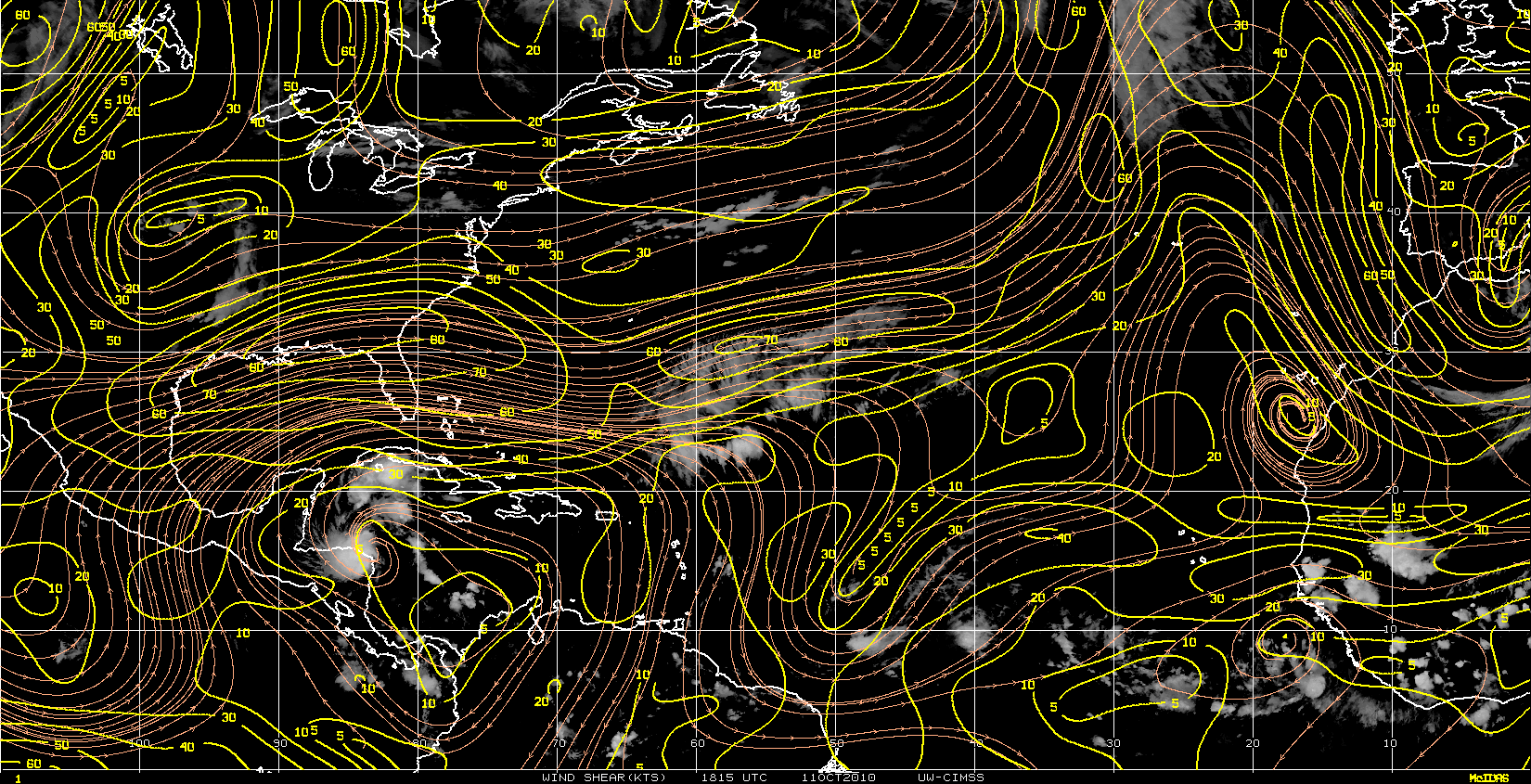
Based on only visible imagery, and looking at the low-level cloud structure, I would put the center just over water.
MW
MW
0 likes
Updating on the twitter now: http://www.twitter.com/@watkinstrack
-
SouthDadeFish
- Professional-Met
- Posts: 2836
- Joined: Thu Sep 23, 2010 2:54 pm
- Location: Miami, FL
- Contact:
jmsewe0,
I would definitely keep a close eye on this disturbance. It appears likely that the NHC will begin to issue advisories this afternoon, and once they do, we should get a better picture of what's going to happen. If I were you I would look for the TS wind probability outlook at your location once advisories begin.
I would definitely keep a close eye on this disturbance. It appears likely that the NHC will begin to issue advisories this afternoon, and once they do, we should get a better picture of what's going to happen. If I were you I would look for the TS wind probability outlook at your location once advisories begin.
0 likes

-
jconsor
- Professional-Met
- Posts: 581
- Joined: Mon Jun 30, 2008 9:31 pm
- Location: Jerusalem, Israel
- Contact:
Re:
Given that 98L continues to move NW and the ridge to its east isn't strong enough to bend it back more to the WNW/W in the next 2 days, I can't see NHC dropping probabilities due to the current proximity to land.
btangy wrote:I think this will be designated a TD or TS in reanalysis extending back since Saturday. I'm still not sure why NHC is going against all the evidence... T numbers, microwave imagery, visible imagery, and ASCAT. Models aren't bullish on development, but are they really initializing the system well? I'm not so sure. The convection isn't right over the center, but that should not be a requirement for a tropical cyclone. If that were the case, we'd have to downgrade every sheared hurricane once it becomes asymmetric. Recon will be in there later, but with the system so close to land, they might not be able to get a VDM out. I can see the NHC going either way this afternoon: dropping probabilities significantly due to proximity to land or upgrading the system to a TD or TS.
0 likes

-
cycloneye

- Admin

- Posts: 149596
- Age: 69
- Joined: Thu Oct 10, 2002 10:54 am
- Location: San Juan, Puerto Rico
Re:
HURAKAN wrote:Puerto Lempira, Honduras:
Noon (16) Oct 11 75 (24) 75 (24) 29.74 (1007) SSW 16 heavy rain
That means low is over water just off the coast.
0 likes
Visit the Caribbean-Central America Weather Thread where you can find at first post web cams,radars
and observations from Caribbean basin members Click Here
and observations from Caribbean basin members Click Here
Re: ATL : INVEST 98L - Discussion
Wow, core has just snapped nicely in place and not very wide.
Heavy convection firing right over the LCC.
Once this gets out into more open water, could ramp up quickly espcially with the anti-cyclone overhead.


Heavy convection firing right over the LCC.
Once this gets out into more open water, could ramp up quickly espcially with the anti-cyclone overhead.
0 likes
-
SouthDadeFish
- Professional-Met
- Posts: 2836
- Joined: Thu Sep 23, 2010 2:54 pm
- Location: Miami, FL
- Contact:
Who is online
Users browsing this forum: No registered users and 36 guests