Texas Winter 2010-2011

Winter Weather Discussion

Moderator: S2k Moderators

Forum rules

The posts in this forum are NOT official forecast and should not be used as such. They are just the opinion of the poster and may or may not be backed by sound meteorological data. They are NOT endorsed by any professional institution or STORM2K.

Help Support Storm2K
Message
Author
User avatar
Ntxw
Storm2k Moderator
Storm2k Moderator
Posts: 22786
Joined: Wed Oct 21, 2009 6:34 pm
Location: DFW, Texas

Re: Texas Winter 2010-2011

#841 Postby Ntxw » Thu Jan 06, 2011 2:00 am

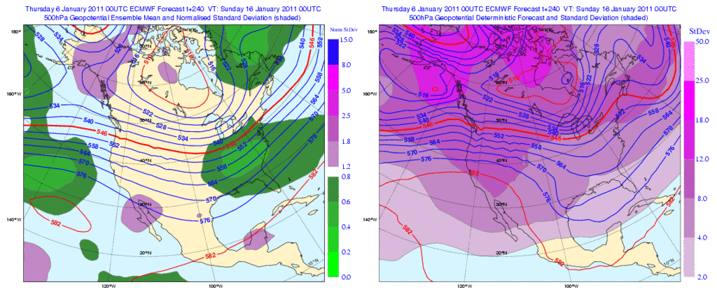
Ok to sum up tonight's 0z, we know about as much as we did last night (basically nothing). Had one good thing which is the ECMWF which has a stronger system across Texas (cutoff). GFS eh so so about it. Then the Euro keeps the cold around basically all week before lifting it out. Afterwards Canada has become Antarctica and who knows what will happen from there.

Image

Nice lil storm we got!
0 likes   
The above post and any post by Ntxw is NOT an official forecast and should not be used as such. It is just the opinion of the poster and may or may not be backed by sound meteorological data. It is NOT endorsed by any professional institution including Storm2k. For official information, please refer to NWS products.

  Help support Storm2K!
Help Support Storm2K

User avatar
iorange55
Category 5
Category 5
Posts: 2388
Joined: Thu Nov 13, 2008 9:47 pm
Location: Big D

Re: Texas Winter 2010-2011

#842 Postby iorange55 » Thu Jan 06, 2011 2:31 am

Well at least today was productive....
0 likes   

User avatar
Portastorm
Storm2k Moderator
Storm2k Moderator
Posts: 9914
Age: 63
Joined: Fri Jul 11, 2003 9:16 am
Location: Round Rock, TX
Contact:

Re: Texas Winter 2010-2011

#843 Postby Portastorm » Thu Jan 06, 2011 6:24 am

I'm sure the "night owls" are in bed early this Thursday but has anyone seen the 6z GFS yet?

At Day 10, single digit temps here in AUS. Lucy's trying to look her best! :lol:
0 likes   

User avatar
Portastorm
Storm2k Moderator
Storm2k Moderator
Posts: 9914
Age: 63
Joined: Fri Jul 11, 2003 9:16 am
Location: Round Rock, TX
Contact:

Re: Texas Winter 2010-2011

#844 Postby Portastorm » Thu Jan 06, 2011 6:34 am

Unfortunately I don't have a lot of time this morning but did come across an excellent morning AFD out of NWSFO San Angelo. Nice, comprehensive discussion. Here is a snippet:

THE SURFACE PRESSURES ACROSS NORTHWEST CANADA HAVE ONLY RISEN A FEW
MB SINCE THIS TIME YESTERDAY BUT THE BLOCKING RIDGE THAT IS EXPECTED
TO PRODUCE THE CROSS POLAR FLOW AND TAP INTO THE FRIGID SIBERIAN AIR
WILL CONTINUE TO BUILD ACROSS AK THROUGH THE WEEKEND. THIS SHOULD
RESULT IN A RAPID INTENSIFICATION OF THE ARCTIC HIGH BY SATURDAY.
THERE IS A DECENT AMOUNT OF SNOW COVER IN PLACE ACROSS ALL OF CANADA
AS WELL AS MUCH OF THE CENTRAL/NORTHERN PLAINS. THIS SHOULD PREVENT
THE AIRMASS FROM MODIFYING TOO QUICKLY AS IT HEADS SOUTH.

THE ACTUAL ARCTIC FRONT IS EXPECTED TO ARRIVE IN WEST CENTRAL TX
DURING THE DAY ON MONDAY. THIS IS JUST SLIGHTLY SLOWER THAN
PREVIOUSLY FORECAST BUT IS REALLY JUST SEMANTIC SINCE WE WILL HAVE
ALREADY EXPERIENCED THE INITIAL FROPA /ON SUNDAY/ AND WILL ALREADY
BE BELOW RATHER COOL. HOWEVER...AS THIS FRONT ARRIVES TEMPS WILL
DROP ANOTHER 15-20 DEGREES. THE GFS IS FASTER THAN THE 00Z RUN
YESTERDAY AND IS FAIRLY SIMILAR TO THE ECMWF. THE GEM STANDS OUT AT
AS THE FASTEST WITH THE COLD AIR PAST INTERSTATE 10 BY 12Z. I AM
SLIGHTLY FASTER THAN THE GFS BUT NOT AS FAST THE GEM. TEMPS SHOULD
TOP OUT NEAR 40 IN THE NORTH TO THE LOWER 50S ALONG I-10 BUT WILL
QUICKLY FALL ONCE THIS FRONT ARRIVES. I CONTEMPLATED PUTTING THE
LIGHT SNOW BACK IN THE FORECAST FOR THE BIG COUNTRY BUT OPTED NOT TO
FOR NOW SINCE I THINK THAT IT WILL MAINLY BE IN THE FORM OF FLURRIES
WITH NO ACCUMULATIONS EXPECTED. OTHERWISE...COLD AND BLUSTERY
CONDITIONS ARE EXPECTED MONDAY AND MONDAY NIGHT.

THE GFS IS MORE PROGRESSIVE WITH THE MID WEEK WAVE AND ERODES THE
COLD AIR MORE QUICKLY THAN I WOULD LIKE. FOLLOWING THE ECMWF PATTERN
MORE CLOSELY...THE NEAR 1050 MB SURFACE HIGH SHOULD BUILD DOWN THE
PLAINS HUGGING THE FRONT RANGE AS A BARRIER JET DEVELOPS IN THE LEE
OF THE ROCKIES. THE SURFACE-H7 FLOW REMAINS PREDOMINANTLY FROM THE
NORTH THROUGH EARLY WEDNESDAY WHICH WOULD KEEP THE COLD AIR FLOWING
SOUTH. THIS REINFORCEMENT OF THE COLD AIRMASS WILL PREVENT LEE
CYCLOGENESIS FROM SCOURING IT OUT TOO QUICKLY. HIGHS ARE EXPECTED TO
BE MAINLY IN THE 30S TUESDAY/WEDNESDAY ALTHOUGH WE COULD START TO
SEE SOME MODIFICATION INTO THE 40S BY WEDNESDAY. A MODEST WARM UP IS
EXPECTED TOWARD THE END OF THE WEEK BUT WE CONTINUE TO SEE A
EAST/WEST ORIENTED TROF EXTENDING ACROSS THE NORTHERN LATITUDES FROM
THE HUDSON BAY VORTEX WITH ADDITIONAL ARCTIC AIR BOTTLED UP OVER
NORTHWEST CANADA READY TO HEAD SOUTH. THIS POINTS TO ANOTHER BLAST
EITHER NEXT WEEKEND OR EARLY THE FOLLOWING WEEK.
0 likes   

orangeblood
S2K Supporter
S2K Supporter
Posts: 3714
Joined: Tue Dec 15, 2009 6:14 pm
Location: Fort Worth, TX

Re: Texas Winter 2010-2011

#845 Postby orangeblood » Thu Jan 06, 2011 7:03 am

Regarding the potential for a secondary arctic front next weekend: After looking at last nights model runs, the polar vortex is going to have to move towards south central/southeast Canada and have more of a north/south orientation for us to feel the brunt of that secondary surge next weekend. As of right now, it appears to be too far west/north and prevents that airmass from coming directly down the leeside of the Rockies. Just something to look for on future model runs.
0 likes   

User avatar
opticsguy
S2K Supporter
S2K Supporter
Posts: 231
Joined: Wed Jan 05, 2011 9:27 pm
Location: McKinney, TX

Re: Texas Winter 2010-2011

#846 Postby opticsguy » Thu Jan 06, 2011 8:22 am

Siberia -70 topic: I believe when it's that cold there is one heck of a temperature inversion (adiabatic lapse rate would imply -80/-90 500mb temperatures). Therefore, all smoke and car exhaust stays a few hundred feet from the ground.
0 likes   

User avatar
txagwxman
Professional-Met
Professional-Met
Posts: 960
Joined: Thu Dec 24, 2009 3:26 pm
Location: Tomball, TX

Re: Texas Winter 2010-2011

#847 Postby txagwxman » Thu Jan 06, 2011 8:41 am

Better hope the 6z GFS isn't right---Armageddon.
Image
0 likes   
“If you thought that science was certain - well, that is just an error on your part.”

User avatar
Kelarie
Category 5
Category 5
Posts: 1074
Age: 54
Joined: Mon Dec 20, 2004 1:18 pm
Location: Hobbs, NM

Re: Texas Winter 2010-2011

#848 Postby Kelarie » Thu Jan 06, 2011 8:55 am

Wow, that shows some crazy numbers. If that actually happens, I wont be leaving the house. :eek:
0 likes   

User avatar
srainhoutx
S2K Supporter
S2K Supporter
Posts: 6919
Age: 67
Joined: Sun Jan 14, 2007 11:34 am
Location: Haywood County, NC
Contact:

Re: Texas Winter 2010-2011

#849 Postby srainhoutx » Thu Jan 06, 2011 8:58 am

txagwxman wrote:Better hope the 6z GFS isn't right---Armageddon.

Image


Oh boy...

Image

Image
0 likes   
Carla/Alicia/Jerry(In The Eye)/Michelle/Charley/Ivan/Dennis/Katrina/Rita/Wilma/Ike/Harvey

Member: National Weather Association
Wx Infinity Forums
http://wxinfinity.com/index.php

Facebook.com/WeatherInfinity
Twitter @WeatherInfinity

User avatar
southerngale
Retired Staff
Retired Staff
Posts: 27418
Joined: Thu Oct 10, 2002 1:27 am
Location: Southeast Texas (Beaumont area)

Re: Texas Winter 2010-2011

#850 Postby southerngale » Thu Jan 06, 2011 9:09 am

Portastorm wrote:Unfortunately I don't have a lot of time this morning but did come across an excellent morning AFD out of NWSFO San Angelo. Nice, comprehensive discussion. Here is a snippet:


That discussion is from our very own wall_cloud. I've been learning more from reading him than from my local guys, who haven't posted much about this yet. He really explains things well.
0 likes   
Please support Storm2k by making a donation today. It is greatly appreciated! Click here: Image

Image my Cowboys Image my RocketsImage my Astros

HockeyTx82
S2K Supporter
S2K Supporter
Posts: 2540
Joined: Tue Oct 27, 2009 11:17 am
Location: Ponder, TX

Re: Texas Winter 2010-2011

#851 Postby HockeyTx82 » Thu Jan 06, 2011 9:23 am

srainhoutx, I think I can read the top graph your quoted, but the bottom four what do you see and for when? I still don't understand how to read those graphics. Also to anyone is next week just looking cold but nothing to impressive. The local mets on the TV this morning are talking like it will get "colder" then warm up. I am a bit lost right now. Are we still waiting on a few things to play out?
Last edited by HockeyTx82 on Thu Jan 06, 2011 9:27 am, edited 1 time in total.
0 likes   
Don't hold me accountable for anything I post on this forum. Leave the real forecasting up to the professionals.

Location: Ponder, TX (all observation posts are this location unless otherwise noted)

djmikey
Tropical Storm
Tropical Storm
Posts: 153
Joined: Tue Jul 20, 2010 6:04 pm
Location: Beaumont, TX

Re: Texas Winter 2010-2011

#852 Postby djmikey » Thu Jan 06, 2011 9:27 am

txagwxman wrote:Better hope the 6z GFS isn't right---Armageddon.

Image

Can someone explain what the 6z GFS is showing? I am unable to pull anything up here at work. Thanks
0 likes   

User avatar
srainhoutx
S2K Supporter
S2K Supporter
Posts: 6919
Age: 67
Joined: Sun Jan 14, 2007 11:34 am
Location: Haywood County, NC
Contact:

Re: Texas Winter 2010-2011

#853 Postby srainhoutx » Thu Jan 06, 2011 9:39 am

HockeyTx82 wrote:srainhoutx, I think I can read the top graph your quoted, but the bottom four what do you see and for when? I still don't understand how to read those graphics. Also to anyone is next week just looking cold but nothing to impressive. The local mets on the TV this morning are talking like it will get "colder" then warm up. I am a bit lost right now. Are we still waiting on a few things to play out?


As we have discussed, there may well be a stepping down process (reinforcing shots, if you will) of colder air spilling S from the building cold across Canada next week. The 00Z GFS ensembles suggest that infact a large surge of bitter cold will start spilling S later next week. As was hinted via San Angelo NWS forecaster Johnson, we need to keep an eye on such a scenario. There are strong telecommunication features as Portastorm mentioned yesterday that a rather potent dump of that building cold air will spill very far S into TX/MX and across much of the Lower 48 in the 14th -16th time frame +/- a day or so. Something to watch as we move into the weekend and next week.
0 likes   
Carla/Alicia/Jerry(In The Eye)/Michelle/Charley/Ivan/Dennis/Katrina/Rita/Wilma/Ike/Harvey

Member: National Weather Association
Wx Infinity Forums
http://wxinfinity.com/index.php

Facebook.com/WeatherInfinity
Twitter @WeatherInfinity

User avatar
southerngale
Retired Staff
Retired Staff
Posts: 27418
Joined: Thu Oct 10, 2002 1:27 am
Location: Southeast Texas (Beaumont area)

#854 Postby southerngale » Thu Jan 06, 2011 9:45 am

A lot of guests are viewing this thread. Don't be shy, guys. Join & say hello. :)
0 likes   
Please support Storm2k by making a donation today. It is greatly appreciated! Click here: Image

Image my Cowboys Image my RocketsImage my Astros

Brandon8181
S2K Supporter
S2K Supporter
Posts: 424
Age: 41
Joined: Tue Jan 04, 2011 4:52 pm
Location: Tyler, TX
Contact:

Re: Texas Winter 2010-2011

#855 Postby Brandon8181 » Thu Jan 06, 2011 9:49 am

srainhoutx wrote:
HockeyTx82 wrote:srainhoutx, I think I can read the top graph your quoted, but the bottom four what do you see and for when? I still don't understand how to read those graphics. Also to anyone is next week just looking cold but nothing to impressive. The local mets on the TV this morning are talking like it will get "colder" then warm up. I am a bit lost right now. Are we still waiting on a few things to play out?


As we have discussed, there may well be a stepping down process (reinforcing shots, if you will) of colder air spilling S from the building cold across Canada next week. The 00Z GFS ensembles suggest that infact a large surge of bitter cold will start spilling S later next week. As was hinted via San Angelo NWS forecaster Johnson, we need to keep an eye on such a scenario. There are strong telecommunication features as Portastorm mentioned yesterday that a rather potent dump of that building cold air will spill very far S into TX/MX and across much of the Lower 48 in the 14th -16th time frame +/- a day or so. Something to watch as we move into the weekend and next week.


This is exactly what I was suggesting last night. Again, I feel this week is only the start of things to come. We will see.

Happy Thursday :)
0 likes   
I am not a meteorologist. Any post from me should be taken as hobby or fun educational information, but not an accurate source for weather information. Please, refer to your local weather station or National Weather Service for the most up to date information. :flag:

utweather
Category 1
Category 1
Posts: 252
Joined: Tue Jan 26, 2010 10:51 pm
Location: SE Austin, TX

Re: Texas Winter 2010-2011

#856 Postby utweather » Thu Jan 06, 2011 10:01 am

srainhoutx wrote:
HockeyTx82 wrote:srainhoutx, I think I can read the top graph your quoted, but the bottom four what do you see and for when? I still don't understand how to read those graphics. Also to anyone is next week just looking cold but nothing to impressive. The local mets on the TV this morning are talking like it will get "colder" then warm up. I am a bit lost right now. Are we still waiting on a few things to play out?


As we have discussed, there may well be a stepping down process (reinforcing shots, if you will) of colder air spilling S from the building cold across Canada next week. The 00Z GFS ensembles suggest that infact a large surge of bitter cold will start spilling S later next week. As was hinted via San Angelo NWS forecaster Johnson, we need to keep an eye on such a scenario. There are strong telecommunication features as Portastorm mentioned yesterday that a rather potent dump of that building cold air will spill very far S into TX/MX and across much of the Lower 48 in the 14th -16th time frame +/- a day or so. Something to watch as we move into the weekend and next week.


Sounds like the real deal. The fact that this is January is what is most concerning. If the models were showing this in February I would say likely glancing blow or maybe worse case 48hr snap then rapid recovery to normal, but this is starting to look very interesting:-)
0 likes   

User avatar
srainhoutx
S2K Supporter
S2K Supporter
Posts: 6919
Age: 67
Joined: Sun Jan 14, 2007 11:34 am
Location: Haywood County, NC
Contact:

Re: Texas Winter 2010-2011

#857 Postby srainhoutx » Thu Jan 06, 2011 10:03 am

The 12Z NAM is painting a mighty wet Saturday/Sunday across the Lone Star State. That model also suggests possible wintry weather in parts of N TX as the Upper Low and surface low in the Gulf begin to shift E.
0 likes   
Carla/Alicia/Jerry(In The Eye)/Michelle/Charley/Ivan/Dennis/Katrina/Rita/Wilma/Ike/Harvey

Member: National Weather Association
Wx Infinity Forums
http://wxinfinity.com/index.php

Facebook.com/WeatherInfinity
Twitter @WeatherInfinity

Brandon8181
S2K Supporter
S2K Supporter
Posts: 424
Age: 41
Joined: Tue Jan 04, 2011 4:52 pm
Location: Tyler, TX
Contact:

Re: Texas Winter 2010-2011

#858 Postby Brandon8181 » Thu Jan 06, 2011 10:11 am

utweather wrote:
srainhoutx wrote:
HockeyTx82 wrote:srainhoutx, I think I can read the top graph your quoted, but the bottom four what do you see and for when? I still don't understand how to read those graphics. Also to anyone is next week just looking cold but nothing to impressive. The local mets on the TV this morning are talking like it will get "colder" then warm up. I am a bit lost right now. Are we still waiting on a few things to play out?


As we have discussed, there may well be a stepping down process (reinforcing shots, if you will) of colder air spilling S from the building cold across Canada next week. The 00Z GFS ensembles suggest that infact a large surge of bitter cold will start spilling S later next week. As was hinted via San Angelo NWS forecaster Johnson, we need to keep an eye on such a scenario. There are strong telecommunication features as Portastorm mentioned yesterday that a rather potent dump of that building cold air will spill very far S into TX/MX and across much of the Lower 48 in the 14th -16th time frame +/- a day or so. Something to watch as we move into the weekend and next week.


Sounds like the real deal. The fact that this is January is what is most concerning. If the models were showing this in February I would say likely glancing blow or maybe worse case 48hr snap then rapid recovery to normal, but this is starting to look very interesting:-)


GFS has consistantly been suggesting this over the last 2 days, but now its really bringing it down...
0 likes   
I am not a meteorologist. Any post from me should be taken as hobby or fun educational information, but not an accurate source for weather information. Please, refer to your local weather station or National Weather Service for the most up to date information. :flag:

WacoWx
Category 2
Category 2
Posts: 664
Joined: Mon Dec 28, 2009 4:14 pm
Location: NOT Waco, TX ----> Dallas, TX

Re: Texas Winter 2010-2011

#859 Postby WacoWx » Thu Jan 06, 2011 10:23 am

Just for those who havent seen it out of the Fort Worth office:
Image
An upper level disturbance will move across north Texas Saturdayevening and Sunday and bring a good chance of rain. Meanwhile a coldfront will move in from the northeast Saturday night andtemperatures will cool into 30s and 40s behind it. Rainfall acrossNorth Texas will range from 1/4 inch in the north to 3/4 inch in thesouth. Higher chances of heavy rain and thunderstorms will be foundalong the Gulf Coast. It may be cold enough for some snow acrossOklahoma and Arkansas late Sunday. An arctic front will bring evencolder air to the region for Tuesday and Wednesday with highs inNorth Texas only in the 30s. Lows will be in the upper teens to mid20s.
0 likes   

User avatar
Longhornmaniac8
Category 1
Category 1
Posts: 254
Joined: Thu Nov 18, 2010 2:30 am
Location: Austin, TX

#860 Postby Longhornmaniac8 » Thu Jan 06, 2011 11:14 am

Hi Guys,

I have a question regarding one of the NWS forecasts from up above:

To what does the "Surface-H7" flow refer, and how does it affect the chances of a reinforcing blast of cold air?

Thanks!

Cheers,
Cameron
0 likes   


Return to “Winter Weather”

Who is online

Users browsing this forum: No registered users and 4 guests