

Nice lil storm we got!
Moderator: S2k Moderators
 The posts in this forum are NOT official forecast and should not be used as such. They are just the opinion of the poster and may or may not be backed by sound meteorological data. They are NOT endorsed by any professional institution or STORM2K.


txagwxman wrote:Better hope the 6z GFS isn't right---Armageddon.


Portastorm wrote:Unfortunately I don't have a lot of time this morning but did come across an excellent morning AFD out of NWSFO San Angelo. Nice, comprehensive discussion. Here is a snippet:

 my Cowboys my Rockets my Astros
txagwxman wrote:Better hope the 6z GFS isn't right---Armageddon.
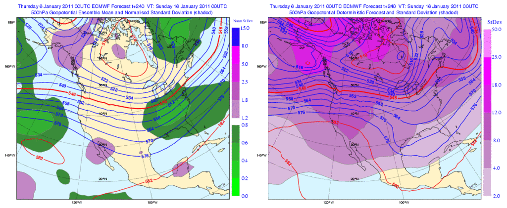
HockeyTx82 wrote:srainhoutx, I think I can read the top graph your quoted, but the bottom four what do you see and for when? I still don't understand how to read those graphics. Also to anyone is next week just looking cold but nothing to impressive. The local mets on the TV this morning are talking like it will get "colder" then warm up. I am a bit lost right now. Are we still waiting on a few things to play out?
srainhoutx wrote:HockeyTx82 wrote:srainhoutx, I think I can read the top graph your quoted, but the bottom four what do you see and for when? I still don't understand how to read those graphics. Also to anyone is next week just looking cold but nothing to impressive. The local mets on the TV this morning are talking like it will get "colder" then warm up. I am a bit lost right now. Are we still waiting on a few things to play out?
As we have discussed, there may well be a stepping down process (reinforcing shots, if you will) of colder air spilling S from the building cold across Canada next week. The 00Z GFS ensembles suggest that infact a large surge of bitter cold will start spilling S later next week. As was hinted via San Angelo NWS forecaster Johnson, we need to keep an eye on such a scenario. There are strong telecommunication features as Portastorm mentioned yesterday that a rather potent dump of that building cold air will spill very far S into TX/MX and across much of the Lower 48 in the 14th -16th time frame +/- a day or so. Something to watch as we move into the weekend and next week.
utweather wrote:srainhoutx wrote:HockeyTx82 wrote:srainhoutx, I think I can read the top graph your quoted, but the bottom four what do you see and for when? I still don't understand how to read those graphics. Also to anyone is next week just looking cold but nothing to impressive. The local mets on the TV this morning are talking like it will get "colder" then warm up. I am a bit lost right now. Are we still waiting on a few things to play out?
As we have discussed, there may well be a stepping down process (reinforcing shots, if you will) of colder air spilling S from the building cold across Canada next week. The 00Z GFS ensembles suggest that infact a large surge of bitter cold will start spilling S later next week. As was hinted via San Angelo NWS forecaster Johnson, we need to keep an eye on such a scenario. There are strong telecommunication features as Portastorm mentioned yesterday that a rather potent dump of that building cold air will spill very far S into TX/MX and across much of the Lower 48 in the 14th -16th time frame +/- a day or so. Something to watch as we move into the weekend and next week.
Sounds like the real deal. The fact that this is January is what is most concerning. If the models were showing this in February I would say likely glancing blow or maybe worse case 48hr snap then rapid recovery to normal, but this is starting to look very interesting:-)


Users browsing this forum: Google Adsense [Bot] and 99 guests


