Deep South Winterwx Discussion 2015-2016

Winter Weather Discussion

Moderator: S2k Moderators

Forum rules

The posts in this forum are NOT official forecast and should not be used as such. They are just the opinion of the poster and may or may not be backed by sound meteorological data. They are NOT endorsed by any professional institution or STORM2K.

Help Support Storm2K
Message
Author
Metalicwx220

Re: Deep South Winterwx thread: January trouble

#3061 Postby Metalicwx220 » Mon Jan 24, 2011 8:39 pm

MississippiWx wrote::uarrow: :uarrow: 
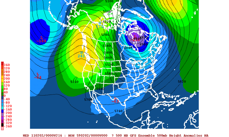
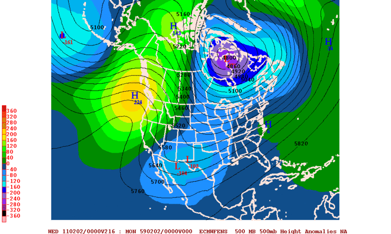
Getting a little too excited about something at 260 hours away. :wink:

The GFS had been showing a major snowstorm for the South for the last five days or so and you see how it doesn't show it anymore. I'm not going to put much stock into anything the models show outside of 5 days, especially when there is no consensus.

I know that.LOL its been showing that everyday though. Has 1-2 inches of snow in florida.
0 likes   

Brent
S2K Supporter
S2K Supporter
Posts: 38107
Age: 37
Joined: Sun May 16, 2004 10:30 pm
Location: Tulsa Oklahoma
Contact:

Re: Deep South Winterwx thread: January trouble

#3062 Postby Brent » Mon Jan 24, 2011 8:41 pm

Image

HAZARDOUS WEATHER OUTLOOK
NATIONAL WEATHER SERVICE BIRMINGHAM AL
606 PM CST MON JAN 24 2011

ALZ011>015-017>050-251930-
MARION-LAMAR-FAYETTE-WINSTON-WALKER-BLOUNT-ETOWAH-CALHOUN-
CHEROKEE-CLEBURNE-PICKENS-TUSCALOOSA-JEFFERSON-SHELBY-ST. CLAIR-
TALLADEGA-CLAY-RANDOLPH-SUMTER-GREENE-HALE-PERRY-BIBB-CHILTON-
COOSA-TALLAPOOSA-CHAMBERS-MARENGO-DALLAS-AUTAUGA-LOWNDES-ELMORE-
MONTGOMERY-MACON-BULLOCK-LEE-RUSSELL-PIKE-BARBOUR-
606 PM CST MON JAN 24 2011

THIS HAZARDOUS WEATHER OUTLOOK IS FOR THE COUNTIES SERVED BY THE
NATIONAL WEATHER SERVICE OFFICE IN BIRMINGHAM.

.DAY ONE...TONIGHT.

NO HAZARDOUS WEATHER IS EXPECTED AT THIS TIME.

.DAYS TWO THROUGH SEVEN...TUESDAY THROUGH SUNDAY.

THERE IS A CHANCE OF SNOW ACROSS NORTH CENTRAL ALABAMA LATE TUESDAY
NIGHT THROUGH EARLY WEDNESDAY MORNING. THE BEST CHANCE OF
SIGNIFICANT ACCUMULATIONS WILL BE NEAR AND NORTH OF A LINE FROM
WINFIELD...TO PIEDMONT...AND IN HIGHER ELEVATIONS EAST OF I-65.

LESSER TOTALS WILL BE POSSIBLE AS FAR SOUTH AS A LINE FROM
REFORM...TO PINSON...TO ROANOKE.

THIS REMAINS A COMPLEX WEATHER SCENARIO WITH REGARDS TO THE TRACK
AND STRENGTH OF THE STORM SYSTEM...AND SLIGHT CHANGES WILL
ULTIMATELY AFFECT PRECIPITATION TYPE AND AMOUNTS. STAY TUNED FOR
FORECAST UPDATES.

.SPOTTER INFORMATION STATEMENT...

ACTIVATION OF STORM SPOTTERS AND EMERGENCY MANAGEMENT IS NOT
EXPECTED AT THIS TIME.

$$
0 likes   
#neversummer

Ynotndalton
Tropical Low
Tropical Low
Posts: 43
Joined: Thu Jan 06, 2011 8:13 pm

Re: Deep South Winterwx thread: January trouble

#3063 Postby Ynotndalton » Mon Jan 24, 2011 8:54 pm

The thing is not to get excited about a GIANT snowstorm forecasted 300 hours away.... But get excited instead of a gulf low and cold air setup .. The general overall picture.. which gives a chance for an event to eventually verify. Doesn't mean it will be a great snowstorm all the way to florida.. ignore the details that far out.. instead look at the big picture.. Southern stream energy .. cold air to the north of it.. It's a setup for a chance for an event.. not a set in stone forecast.
0 likes   

bella_may
Category 4
Category 4
Posts: 908
Joined: Wed Dec 22, 2010 2:13 pm
Location: SE Mississippi coast

Re: Deep South Winterwx thread: January trouble

#3064 Postby bella_may » Mon Jan 24, 2011 9:17 pm

So is it pretty much a sure thing it will snow in south mississippi the first week of feb.? Or is it still kinda iffy?
0 likes   

User avatar
Tstormwatcher
S2K Supporter
S2K Supporter
Posts: 3086
Joined: Thu Oct 20, 2005 7:31 pm
Location: New Bern, NC

#3065 Postby Tstormwatcher » Mon Jan 24, 2011 9:24 pm

It's iffy at best.
0 likes   

Dean4Storms
S2K Supporter
S2K Supporter
Posts: 6358
Age: 62
Joined: Sun Aug 31, 2003 1:01 pm
Location: Miramar Bch. FL

#3066 Postby Dean4Storms » Mon Jan 24, 2011 9:40 pm

I wouldn't put much stock in any of it just yet.
0 likes   

Kennethb
Category 2
Category 2
Posts: 506
Joined: Thu Aug 14, 2003 7:15 am
Location: Baton Rouge

Re: Deep South Winterwx thread: January trouble

#3067 Postby Kennethb » Mon Jan 24, 2011 9:53 pm

It could snow in the deep south (I-10 corridor) the first week of February as much as it may not snow here for another 10 years or more.
0 likes   

Jag95
Category 1
Category 1
Posts: 438
Joined: Sat Aug 15, 2009 8:43 pm
Location: Mobile, AL

Re: Deep South Winterwx thread: January trouble

#3068 Postby Jag95 » Mon Jan 24, 2011 9:55 pm

ECMWF shows a polar vortex working it's way SSE in Canada through 7 days with a 1044mb high off to the west. Looks locked and loaded on the 1/31.
Image
0 likes   

Metalicwx220

#3069 Postby Metalicwx220 » Mon Jan 24, 2011 10:09 pm

Image
I just love how IT Disappears like that. :roll: :roll: :roll: :roll: :roll: :roll: :roll: :roll: :roll:
0 likes   

User avatar
vbhoutex
Storm2k Executive
Storm2k Executive
Posts: 29113
Age: 73
Joined: Wed Oct 09, 2002 11:31 pm
Location: Cypress, TX
Contact:

Re: Deep South Winterwx thread: January trouble

#3070 Postby vbhoutex » Mon Jan 24, 2011 10:11 pm

Kennethb wrote:It could snow in the deep south (I-10 corridor) the first week of February as much as it may not snow here for another 10 years or more.

Truer words were never spoken!!
0 likes   
Skywarn, C.E.R.T.
Please click below to donate to STORM2K to help with the expenses of keeping the site going:
Image

User avatar
Ivanhater
Storm2k Moderator
Storm2k Moderator
Posts: 11162
Age: 38
Joined: Fri Jul 01, 2005 8:25 am
Location: Pensacola

Re: Deep South Winterwx thread: January trouble

#3071 Postby Ivanhater » Mon Jan 24, 2011 10:16 pm

Metalicwx, have you been paying attention to what we have been saying? You can't look at the snowfall maps to determine if there will be a storm or not. It is much more complex. I refer back to wxman57's post from this morning.

Edited by wxman57:

The first image below is the GFS ensemble forecast of 500mb (mid level) height anomalies valid Tuesday evening, February 1st. The map shows building high pressure over the Gulf of Alaska and Pacific Northwest and a deepening low over the eastern Hudson Bay region extending all the way southwest to west of Texas.

The suggestion here is that the building ridge will drive very cold air southward out of Canada but that the trof axis will remain west of the cold air next Tue-Wed. This is a setup for snow across the Deep South.

Image

The European version of the same map has an even deeper area of low pressure west of the cold air across the southwestern U.S. next Tuesday evening. The European model is more bullish on southern stream energy with the cold air in place, meaning a greater chance for Deep South snow next week.
Image
0 likes   
Michael

Ynotndalton
Tropical Low
Tropical Low
Posts: 43
Joined: Thu Jan 06, 2011 8:13 pm

Re: Deep South Winterwx thread: January trouble

#3072 Postby Ynotndalton » Mon Jan 24, 2011 10:18 pm

I think its going to be interesting from a meteorology standpoint to watch this highly dynamic cold core upper low in action tomm evening -> Wed morning creating it's own atmosphere to work with.
0 likes   

Ynotndalton
Tropical Low
Tropical Low
Posts: 43
Joined: Thu Jan 06, 2011 8:13 pm

Re: Deep South Winterwx thread: January trouble

#3073 Postby Ynotndalton » Mon Jan 24, 2011 10:21 pm

Radars will be reflecting as if rain in many places across alabama and tenn tomm where it will actually be snowing heavily for a while.
0 likes   

Metalicwx220

Re: Deep South Winterwx thread: January trouble

#3074 Postby Metalicwx220 » Mon Jan 24, 2011 10:29 pm

Ivanhater wrote:Metalicwx, have you been paying attention to what we have been saying? You can't look at the snowfall maps to determine if there will be a storm or not. It is much more complex. I refer back to wxman57's post from this morning.

Edited by wxman57:

The first image below is the GFS ensemble forecast of 500mb (mid level) height anomalies valid Tuesday evening, February 1st. The map shows building high pressure over the Gulf of Alaska and Pacific Northwest and a deepening low over the eastern Hudson Bay region extending all the way southwest to west of Texas.

The suggestion here is that the building ridge will drive very cold air southward out of Canada but that the trof axis will remain west of the cold air next Tue-Wed. This is a setup for snow across the Deep South.

Image

The European version of the same map has an even deeper area of low pressure west of the cold air across the southwestern U.S. next Tuesday evening. The European model is more bullish on southern stream energy with the cold air in place, meaning a greater chance for Deep South snow next week.
Image

I pay attention I just don't look at it that way. I like to see it even though analyzing it is much better as you all are doing.
0 likes   

Metalicwx220

Re: Deep South Winterwx thread: January trouble

#3075 Postby Metalicwx220 » Mon Jan 24, 2011 10:39 pm

Ynotndalton wrote:I think its going to be interesting from a meteorology standpoint to watch this highly dynamic cold core upper low in action tomm evening -> Wed morning creating it's own atmosphere to work with.

YEAH....... lets see is their an 8 inch blizzard like in the carolinas that couldn't be predicted 6 hours out. It never ceases to amaze me from these situations.
0 likes   

Brent
S2K Supporter
S2K Supporter
Posts: 38107
Age: 37
Joined: Sun May 16, 2004 10:30 pm
Location: Tulsa Oklahoma
Contact:

Re: Deep South Winterwx thread: January trouble

#3076 Postby Brent » Tue Jan 25, 2011 2:55 am

The smell of FAIL is in the air... the 0z models don't have a single snowflake below Huntsville.

Image
0 likes   
#neversummer

Ynotndalton
Tropical Low
Tropical Low
Posts: 43
Joined: Thu Jan 06, 2011 8:13 pm

Re: Deep South Winterwx thread: January trouble

#3077 Postby Ynotndalton » Tue Jan 25, 2011 7:16 am

Ya i've noticed brent the best forcing with the UL seems to have migrated north the last few runs now moving from north MS through north al into east tenn.. probably missing me in N ga as well.. which explains NWS peachtree's reluctance to bite.
0 likes   

Ynotndalton
Tropical Low
Tropical Low
Posts: 43
Joined: Thu Jan 06, 2011 8:13 pm

Re: Deep South Winterwx thread: January trouble

#3078 Postby Ynotndalton » Tue Jan 25, 2011 7:20 am

BTW.. finally the local news out of Chattanooga .. channel 9 finally mentioned something about watching the potential for a big snowstorm the first week of Feb.
0 likes   

User avatar
Ivanhater
Storm2k Moderator
Storm2k Moderator
Posts: 11162
Age: 38
Joined: Fri Jul 01, 2005 8:25 am
Location: Pensacola

Re: Deep South Winterwx thread: January trouble

#3079 Postby Ivanhater » Tue Jan 25, 2011 8:27 am

Oh look, our 1st week of February storm is still there on the 00z GFS :wink:

Again, we will focus on the details as we get closer to the event. We have the cold and we have the storm, couldn't ask for more at this point

Image

Image
0 likes   
Michael

Ynotndalton
Tropical Low
Tropical Low
Posts: 43
Joined: Thu Jan 06, 2011 8:13 pm

Re: Deep South Winterwx thread: January trouble

#3080 Postby Ynotndalton » Tue Jan 25, 2011 9:05 am

I agree brent.. i'm excited about the setup.. someone will get a snowstorm.. somewhere out of this..
0 likes   


Return to “Winter Weather”

Who is online

Users browsing this forum: No registered users and 33 guests