Texas Winter 2010-2011

Winter Weather Discussion

Moderator: S2k Moderators

Forum rules

The posts in this forum are NOT official forecast and should not be used as such. They are just the opinion of the poster and may or may not be backed by sound meteorological data. They are NOT endorsed by any professional institution or STORM2K.

Help Support Storm2K
Message
Author
Metalicwx220

Re: Texas Winter 2010-2011

#3381 Postby Metalicwx220 » Wed Jan 26, 2011 5:52 pm

Ntxw wrote:
iorange55 wrote:18z GFS looks like the same GFS so far. It's frustrating to watch it cause it just looks so meh compared to the other models. I want that cold air to push down with a vengeance.


Upside is it does show a lot of moisture.


Full fledged blizzard in the panhandle, I'd take some of that! Vortmax is definitely south. I like the shortwave look. And it's not being disturbed by any other feature, in the process of cutting off.

Image
Thats not that far. :roll: :roll: :roll:
0 likes   

Brandon8181
S2K Supporter
S2K Supporter
Posts: 424
Age: 41
Joined: Tue Jan 04, 2011 4:52 pm
Location: Tyler, TX
Contact:

Re: Re:

#3382 Postby Brandon8181 » Wed Jan 26, 2011 5:54 pm

Tireman4 wrote:
WacoWx wrote:
Ntxw wrote:18z GFS looks decent, especially for 150+ hours out. Trending colder. Unfortunately this run leaves WacoWx right on the cusp again! Looks like the system will have an impressive trowel much like the other strong storms. Vertical motion.


I'm moving to DFW in 2 weeks to avoid this problem down the road. Your avatar will no longer haunt me. But until then..... :cry:


Gotta do what you gotta do. If it never snowed here, I would consider moving to the north pole if I had to...


Gosh that is drastic. Just for snow...LOL......Goodness...
0 likes   
I am not a meteorologist. Any post from me should be taken as hobby or fun educational information, but not an accurate source for weather information. Please, refer to your local weather station or National Weather Service for the most up to date information. :flag:

User avatar
Tireman4
S2K Supporter
S2K Supporter
Posts: 5853
Age: 59
Joined: Fri Jun 30, 2006 1:08 pm
Location: Humble, Texas
Contact:

Re: Texas Winter 2010-2011

#3383 Postby Tireman4 » Wed Jan 26, 2011 5:56 pm

Metalicwx220 wrote:
Ntxw wrote:
iorange55 wrote:18z GFS looks like the same GFS so far. It's frustrating to watch it cause it just looks so meh compared to the other models. I want that cold air to push down with a vengeance.


Upside is it does show a lot of moisture.


Full fledged blizzard in the panhandle, I'd take some of that! Vortmax is definitely south. I like the shortwave look. And it's not being disturbed by any other feature, in the process of cutting off.

Thats not that far. :roll: :roll: :roll:


Did not that map say a few days ago that the southern part of Texas would have, in some parts, six inches of snow?
Last edited by srainhoutx on Wed Jan 26, 2011 8:01 pm, edited 1 time in total.
Reason: Delete Image
0 likes   

BigB0882
S2K Supporter
S2K Supporter
Posts: 2284
Joined: Thu Jul 03, 2003 12:08 am
Location: Baton Rouge, LA
Contact:

#3384 Postby BigB0882 » Wed Jan 26, 2011 5:58 pm

OK for the win on that map! Hope it has time to change and we can get some along the Gulf Coast.
0 likes   

User avatar
jasons2k
Storm2k Executive
Storm2k Executive
Posts: 8245
Age: 51
Joined: Wed Jul 06, 2005 12:32 pm
Location: The Woodlands, TX

Re: Re:

#3385 Postby jasons2k » Wed Jan 26, 2011 5:59 pm

WacoWx wrote:
Ntxw wrote:18z GFS looks decent, especially for 150+ hours out. Trending colder. Unfortunately this run leaves WacoWx right on the cusp again! Looks like the system will have an impressive trowel much like the other strong storms. Vertical motion.


I'm moving to DFW in 2 weeks to avoid this problem down the road. Your avatar will no longer haunt me. But until then..... :cry:


It's never good enough, trust me. I lived many years in the DFW area....all I did was envy Lubbock, Wichita Falls, and OKC. I did something about it and went to school at Tech. And I spent those 4 winters wishing I was in Amarillo or Dalhart.........
0 likes   

downsouthman1
Category 2
Category 2
Posts: 663
Age: 45
Joined: Fri Jan 07, 2011 8:14 pm
Location: Rowlett, TX

Re: Texas Winter 2010-2011

#3386 Postby downsouthman1 » Wed Jan 26, 2011 6:00 pm

Upside is it does show a lot of moisture.[/quote]

Full fledged blizzard in the panhandle, I'd take some of that! Vortmax is definitely south. I like the shortwave look. And it's not being disturbed by any other feature, in the process of cutting off.[/quote]
Thats not that far. :roll: :roll: :roll:[/quote]

It'd be very difficult for me to see a foot of snowpack on the ground in OK & Texas panhandle and hardly a flake accumulating south of the Red River?
Last edited by srainhoutx on Wed Jan 26, 2011 8:01 pm, edited 3 times in total.
Reason: Delete Image
0 likes   
Not a professional MET! My posts are merely speculation.

User avatar
Ntxw
Storm2k Moderator
Storm2k Moderator
Posts: 22793
Joined: Wed Oct 21, 2009 6:34 pm
Location: DFW, Texas

Re: Texas Winter 2010-2011

#3387 Postby Ntxw » Wed Jan 26, 2011 6:02 pm

Yeah I think we should hold off on these snow maps. We have no idea where the convergence zone will set up as we haven't figured out which model is best to use for temps. It could be in Kansas, it could be in Mexico...

*Or everyone in between via Canadian/JMA*
0 likes   
The above post and any post by Ntxw is NOT an official forecast and should not be used as such. It is just the opinion of the poster and may or may not be backed by sound meteorological data. It is NOT endorsed by any professional institution including Storm2k. For official information, please refer to NWS products.

  Help support Storm2K!
Help Support Storm2K

Metalicwx220

Re: Texas Winter 2010-2011

#3388 Postby Metalicwx220 » Wed Jan 26, 2011 6:11 pm

Metalicwx220 wrote:
Ntxw wrote:
iorange55 wrote:18z GFS looks like the same GFS so far. It's frustrating to watch it cause it just looks so meh compared to the other models. I want that cold air to push down with a vengeance.


Full fledged blizzard in the panhandle, I'd take some of that! Vortmax is definitely south. I like the shortwave look. And it's not being disturbed by any other feature, in the process of cutting off.


Thats not that far. :roll: :roll: :roll:


Did not that map say a few days ago that the southern part of Texas would have, in some parts, six inches of snow?

Yeah at 264 hours.
Last edited by srainhoutx on Wed Jan 26, 2011 8:00 pm, edited 1 time in total.
Reason: Delete Image
0 likes   

User avatar
TwisterFanatic
Category 5
Category 5
Posts: 1041
Joined: Mon Jun 28, 2010 12:43 pm
Location: Sallisaw, Oklahoma

#3389 Postby TwisterFanatic » Wed Jan 26, 2011 6:36 pm

I'll take the 18z GFS for 300, Alex. :D
0 likes   
Personal Forecast Disclaimer:
The posts in this forum are NOT official forecast and should not be used as such. They are just the opinion of the poster and may or may not be backed by sound meteorological data. They are NOT endorsed by any professional institution or storm2k.org. For official information, please refer to the NHC and NWS products.

User avatar
DentonGal
Tropical Storm
Tropical Storm
Posts: 189
Joined: Sun Dec 27, 2009 6:25 am
Location: Denton, TX

#3390 Postby DentonGal » Wed Jan 26, 2011 7:22 pm

All local DFW mets talking about cold and moisture coming through Tuesday next week.
0 likes   
Mom to 8 really is enough!

User avatar
Ntxw
Storm2k Moderator
Storm2k Moderator
Posts: 22793
Joined: Wed Oct 21, 2009 6:34 pm
Location: DFW, Texas

Re:

#3391 Postby Ntxw » Wed Jan 26, 2011 7:35 pm

DentonGal wrote:All local DFW mets talking about cold and moisture coming through Tuesday next week.


I saw that! They seem to be going liberal with it.
0 likes   
The above post and any post by Ntxw is NOT an official forecast and should not be used as such. It is just the opinion of the poster and may or may not be backed by sound meteorological data. It is NOT endorsed by any professional institution including Storm2k. For official information, please refer to NWS products.


  Help support Storm2K!

Help Support Storm2K


downsouthman1
Category 2
Category 2
Posts: 663
Age: 45
Joined: Fri Jan 07, 2011 8:14 pm
Location: Rowlett, TX

Re:

#3392 Postby downsouthman1 » Wed Jan 26, 2011 7:36 pm

DentonGal wrote:All local DFW mets talking about cold and moisture coming through Tuesday next week.


If this pattern persists, Texas will get national attention, especially in DFW due to the Super Bowl. The Weather Channel, CNN, CBS, NBC, FOX, & ABC will have people in DFW talking about the weather & Super Bowl. Don't get it twisted. The game will be played, unless roads are closed & I doubt that's what we're talking about here. Time will tell.
0 likes   
Not a professional MET! My posts are merely speculation.

User avatar
Tireman4
S2K Supporter
S2K Supporter
Posts: 5853
Age: 59
Joined: Fri Jun 30, 2006 1:08 pm
Location: Humble, Texas
Contact:

#3393 Postby Tireman4 » Wed Jan 26, 2011 7:37 pm

Flip, flop, flip, flop....tumbling exercises for all...:)
0 likes   

Peanut432
Tropical Storm
Tropical Storm
Posts: 119
Joined: Mon Jan 25, 2010 10:21 pm
Location: Hollis Ok

#3394 Postby Peanut432 » Wed Jan 26, 2011 7:55 pm

How reliable is the 18z GFS really though? Has the GFS been a decent medium range model?
0 likes   

BigB0882
S2K Supporter
S2K Supporter
Posts: 2284
Joined: Thu Jul 03, 2003 12:08 am
Location: Baton Rouge, LA
Contact:

#3395 Postby BigB0882 » Wed Jan 26, 2011 8:00 pm

I am not 100% but the medium range seems to be when the GFS has a lot of issues and the 18z is less reliable than the 00z and 12z. Someone more informed can correct me. However, it doesn't mean the GFS isn't on to something but I have no doubt it will change somewhat, or a lot...
0 likes   

User avatar
srainhoutx
S2K Supporter
S2K Supporter
Posts: 6919
Age: 67
Joined: Sun Jan 14, 2007 11:34 am
Location: Haywood County, NC
Contact:

Re: Texas Winter 2010-2011

#3396 Postby srainhoutx » Wed Jan 26, 2011 8:03 pm

Hey folks. No need to repost images multiple times. We saw it the first time. It keeps the thread 'cleaner', so to speak. :wink:
0 likes   
Carla/Alicia/Jerry(In The Eye)/Michelle/Charley/Ivan/Dennis/Katrina/Rita/Wilma/Ike/Harvey

Member: National Weather Association
Wx Infinity Forums
http://wxinfinity.com/index.php

Facebook.com/WeatherInfinity
Twitter @WeatherInfinity

Turtle
Category 1
Category 1
Posts: 285
Joined: Wed Jan 20, 2010 9:02 pm
Location: East Texas

Re: Texas Winter 2010-2011

#3397 Postby Turtle » Wed Jan 26, 2011 8:36 pm

From Shreveport NWS AFD Discussion:

. BY SATURDAY
NIGHT...SCATTERED SHOWERS SHOULD MOVE INTO THE REGION FROM THE
SOUTHWEST. THE SYSTEM WILL MOVE QUICKLY ACROSS THE SOUTHERN STATES
ON SUNDAY...ONLY IT WILL BE BE FOLLOWED BY ANOTHER EARLY NEXT
WEEK. THIS SYSTEM LOOKS MUCH COLDER AND SHOULD BRING BACK BELOW
NORMAL TEMPERATURES. CANNOT TOTALLY RULE OUT SOME WINTER PRECIPITATION
IN THE FORM OF FREEZING RAIN...TUESDAY INTO WEDNESDAY... BUT FOR
NOW KEEPING TEMPERATURES JUST ABOVE FREEZING IN THE PRECIP AREAS.
0 likes   

User avatar
txagwxman
Professional-Met
Professional-Met
Posts: 960
Joined: Thu Dec 24, 2009 3:26 pm
Location: Tomball, TX

Re:

#3398 Postby txagwxman » Wed Jan 26, 2011 9:19 pm

Rgv20 wrote:Midland afternoon discussion

BY LATE SUNDAY NIGHT....THERE IS DECENT AGREEMENT THAT A DIGGING
NPAC LOW WILL DIVE SOUTH NEAR NV. AFTER WHICH...THE NWP MODELS
DIFFER ON WHERE IT WILL END UP IN THE EXTENDED FORECAST. THE GFS
DEVELOPS A BRIEF CUTOFF LOW WITH IT AND SLOWLY PROGRESSES IT
EASTWARD OVER NM TUESDAY. THE ECMWF QUICKLY MOVES IT THROUGH
MONDAY NIGHT...AS A WESTERN CANADIAN SHORTWAVE TROUGH DIVES SOUTH
INTO THE NORTHERN ROCKIES. REGARDLESS...ALL OF THE SOLUTIONS SHOW
AN ARCTIC AIR-MASS SLIDING INTO THE NORTHERN PLAINS SOMETIME EARLY
NEXT WEEK AND A COLD FRONT PASSING THROUGH WEST TEXAS AS EARLY AS
MONDAY NIGHT (GFS). THE ECMWF WAS PREVIOUSLY THE COLDEST
SOLUTION...WITH RIDICULOUS 850MB TEMPS NEAR -15C OVER MAF TUESDAY.
THE GFS NOW APPEARS TO BE THE MOST AGGRESSIVE/COLDEST SOLUTION AND
IS ALSO WET WITH THE SLOWER PROGRESSION OF THE UPPER FEATURE. WE
HAVE INCLUDED SCHC POPS IN THE EXTENDED SINCE THE GFS HAS BEEN
VERY CONSISTENT WITH THIS SOLUTION...AND...WE HAVE LOWER MAX TEMPS
FOR TUESDAY AS WELL CONSIDERING THE PREVIOUS COMBINED WITH ISENTROPIC
ASCENT/UPSLOPE REGIME CURRENTLY PROGGED. THE EXTENDED WILL BE
MONITORED CLOSELY FOR THE POSSIBILITY OF HAZARDOUS WINTER WEATHER
IMPACTING THE NORTHERN ZONES IN THE FORM OF FREEZING RAIN OR SNOW
EARLY NEXT WEEK.

I love how NWS uses ISENTROPIC ASCENT/UPSLOPE...which means warm advection aloft.
0 likes   
“If you thought that science was certain - well, that is just an error on your part.”

User avatar
txagwxman
Professional-Met
Professional-Met
Posts: 960
Joined: Thu Dec 24, 2009 3:26 pm
Location: Tomball, TX

Re:

#3399 Postby txagwxman » Wed Jan 26, 2011 9:20 pm

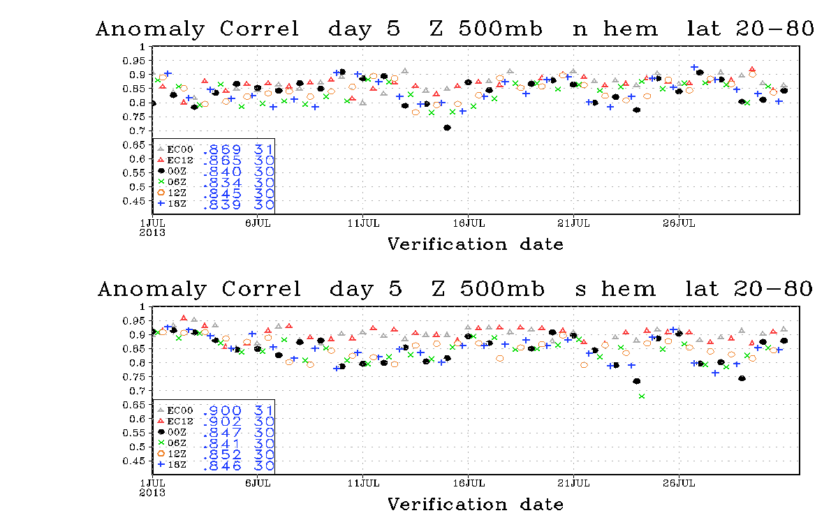
BigB0882 wrote:I am not 100% but the medium range seems to be when the GFS has a lot of issues and the 18z is less reliable than the 00z and 12z. Someone more informed can correct me. However, it doesn't mean the GFS isn't on to something but I have no doubt it will change somewhat, or a lot...

Image
18z, 6z are barely worse than the 00z/12z GFS.
0 likes   
“If you thought that science was certain - well, that is just an error on your part.”

BigB0882
S2K Supporter
S2K Supporter
Posts: 2284
Joined: Thu Jul 03, 2003 12:08 am
Location: Baton Rouge, LA
Contact:

#3400 Postby BigB0882 » Wed Jan 26, 2011 9:28 pm

Well I just said less reliable, I wasn't trying to insinuate that the 18z is horrible and not comparable to the other runs. Thank you for those graphs!
0 likes   


Return to “Winter Weather”

Who is online

Users browsing this forum: No registered users and 21 guests